Bridge Statistics for Sheldon, Texas (TX)
Condition, Traffic, Stress, Structural Evaluation, Project Costs
- National Bridge Inventory (NBI) Statistics
- 22Number of bridges
- 509ft / 155mTotal length
- 216,323Total average daily traffic
- 15,033Total average daily truck traffic
- National Bridge Inventory (NBI) Registered Bridges for Sheldon
- No street view available for this location
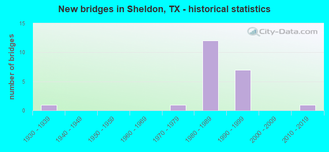
- New bridges - historical statistics
- 11930-1939
- 11970-1979
- 121980-1989
- 71990-1999
- 12010-2019


- Bridge Condition - Deck
- 33.3%Good
- 66.7%Satisfactory

- Bridge Condition - Superstructure
- 40.0%Very good
- 53.3%Good
- 6.7%Satisfactory

- Bridge Condition - Substructure
- 6.7%Very good
- 40.0%Good
- 40.0%Satisfactory
- 13.3%Fair

- Bridge Condition - Channel
- 50.0%Good
- 50.0%Satisfactory

- Bridge Condition - Culverts
- 20.0%Good
- 80.0%Satisfactory
Find on map >> Show street view
Structure Number: 121020002801005, Location: 0.35 MI SW OF SHELDON RD (Lat: 29.865894, Lng: -95.133317), Route carried "on" structure: Business State highway 90, Year Built: 1930, Year Reconstructed: 1960, Status: Open, Structure Length: 0.64m (2.10ft), Average Daily Traffic: 4,220 (year 2013), Truck Traffic: 8%, Average Future Daily Traffic: 5,900 (year 2033), Features Intersected: DRAINAGE DITCH
Minimum Vertical Clearance: 30+ m (98+ ft), Kilometerpoint: 54.298, Lanes on structure: 4, Owner: State Highway Agency, Approaching Roadway Width: 17.7m (58.1ft), Material/Design: Concrete, Design/Construction: Culvert, Number Of Spans In Main Unit: 2, Length of Maximum Span: 3.0m (9.8ft)
Condition: Channel: Good, Culverts: Satisfactory, Operating Rating: 32.7 metric tons, Method Used To Determine Operating Rating: Field evaluation and documented engineering judgment, Inventory Rating: 24.5 metric tons, Method Used To Determine Inventory Rating: Field evaluation and documented engineering judgment, Structural Evaluation: Equal to present minimum criteria, Waterway Adequacy: Equal to present minimum criteria, Approach Roadway Alignment: Equal to present desirable criteria, Designated Inspection Frequency: Every 24 months, Inspection Date: September 2020
Find on map >> Show street view
Structure Number: 121020002802171, Location: 1.00 MI E OF BW 8 (Lat: 29.839836, Lng: -95.160833), Route carried "on" structure: ServiceUS 90, Year Built: 1989, Status: Open, Structure Length: 5.03m (16.50ft), Average Daily Traffic: 9,210 (year 2013), Average Future Daily Traffic: 12,890 (year 2033), Design Load: HS 20, Features Intersected: CARPENTERS BAYOU
Minimum Vertical Clearance: 30+ m (98+ ft), Kilometerpoint: 16.319, Lanes on structure: 2, Owner: State Highway Agency, Approaching Roadway Width: 12.2m (40.0ft), Skew: 1 degrees, Material/Design: Prestressed concrete, Design/Construction: Stringer/Multi-beam, Number Of Spans In Main Unit: 3, Length of Maximum Span: 16.8m (55.1ft), Curb-To-Curb Width: 12.0m (39.4ft), Out-to-Out Width: 12.8m (42.0ft)
Condition: Deck: Satisfactory, Superstructure: Good, Substructure: Good, Channel: Satisfactory, Operating Rating: 54.4 metric tons, Method Used To Determine Operating Rating: Assigned rating based on Load Factor Design (LFD) reported in metric tons, Inventory Rating: 32.7 metric tons, Method Used To Determine Inventory Rating: Assigned rating based on Load Factor Design (LFD) reported in metric tons, Structural Evaluation: Better than present minimum criteria, Deck Geometry: Better than present minimum criteria, Waterway Adequacy: Better than present minimum criteria, Approach Roadway Alignment: Equal to present desirable criteria, Designated Inspection Frequency: Every 24 months, Inspection Date: August 2020, Deck Structure Type: Concrete Cast-file-Place
Find on map >> Show street view
Structure Number: 121020002802175, Location: 1.30 MI SW OF SHELDON RD (Lat: 29.843972, Lng: -95.149547), Route carried "on" structure: US 90, Year Built: 1987, Status: Open, Structure Length: 0.64m (2.10ft), Average Daily Traffic: 46,513 (year 2020), Truck Traffic: 8%, Average Future Daily Traffic: 34,110 (year 2033), Design Load: HS 20, Features Intersected: DRAIN
Minimum Vertical Clearance: 30+ m (98+ ft), Kilometerpoint: 17.679, Lanes on structure: 8, Owner: State Highway Agency, Approaching Roadway Width: 37.2m (122.0ft), Material/Design: Concrete, Design/Construction: Culvert, Number Of Spans In Main Unit: 3, Length of Maximum Span: 2.1m (6.9ft)
Condition: Channel: Good, Culverts: Good, Operating Rating: 39.9 metric tons, Method Used To Determine Operating Rating: Load Factor (LF), Inventory Rating: 23.6 metric tons, Method Used To Determine Inventory Rating: Load Factor (LF), Structural Evaluation: Somewhat better than minimum adequacy, Waterway Adequacy: Equal to present minimum criteria, Approach Roadway Alignment: Equal to present desirable criteria, Designated Inspection Frequency: Every 48 months, Inspection Date: September 2020
Find on map >> Show street view
Structure Number: 121020002802177, Location: 0.30 MI SW OF SHELDON RD (Lat: 29.851597, Lng: -95.131794), Route carried "on" structure: ServiceUS 90, Year Built: 1987, Status: Open, Structure Length: 0.91m (2.99ft), Average Daily Traffic: 1,080 (year 2010), Truck Traffic: 3%, Average Future Daily Traffic: 6,020 (year 2030), Design Load: HS 20, Features Intersected: NORTH DITCH #1
Minimum Vertical Clearance: 30+ m (98+ ft), Kilometerpoint: 19.401, Lanes on structure: 2, Owner: State Highway Agency, Approaching Roadway Width: 12.2m (40.0ft), Skew: 4 degrees, Material/Design: Concrete, Design/Construction: Culvert, Number Of Spans In Main Unit: 2, Length of Maximum Span: 3.0m (9.8ft)
Condition: Channel: Satisfactory, Culverts: Satisfactory, Operating Rating: 39.9 metric tons, Method Used To Determine Operating Rating: Load Factor (LF), Inventory Rating: 23.6 metric tons, Method Used To Determine Inventory Rating: Load Factor (LF), Structural Evaluation: Equal to present minimum criteria, Waterway Adequacy: Equal to present minimum criteria, Approach Roadway Alignment: Equal to present desirable criteria, Designated Inspection Frequency: Every 48 months, Inspection Date: September 2020
Find on map >> Show street view
Structure Number: 121020002802178, Location: 3.2 MI NE OF BW 8 (Lat: 29.852889, Lng: -95.127886), Route carried "on" structure: US 90, Year Built: 1987, Status: Open, Structure Length: 8.23m (27.00ft), Average Daily Traffic: 12,180 (year 2013), Truck Traffic: 8%, Average Future Daily Traffic: 17,050 (year 2033), Design Load: HS 20, Features Intersected: SHELDON RD
Minimum Vertical Clearance: 30+ m (98+ ft), Kilometerpoint: 19.835, Lanes on structure: 2, Lanes under structure: 6, Owner: State Highway Agency, Approaching Roadway Width: 12.2m (40.0ft), Skew: 2 degrees, Material/Design: Prestressed concrete, Design/Construction: Stringer/Multi-beam, Number Of Spans In Main Unit: 1, Number Of Approach Spans: 2, Length of Maximum Span: 36.6m (120.1ft), Curb-To-Curb Width: 11.3m (37.1ft), Out-to-Out Width: 12.2m (40.0ft)
Condition: Deck: Good, Superstructure: Good, Substructure: Satisfactory, Operating Rating: 54.4 metric tons, Method Used To Determine Operating Rating: Assigned rating based on Load Factor Design (LFD) reported in metric tons, Inventory Rating: 32.7 metric tons, Method Used To Determine Inventory Rating: Assigned rating based on Load Factor Design (LFD) reported in metric tons, Structural Evaluation: Equal to present minimum criteria, Deck Geometry: Somewhat better than minimum adequacy, Underclear: Equal to present minimum criteria, Approach Roadway Alignment: Equal to present desirable criteria, Designated Inspection Frequency: Every 24 months, Inspection Date: August 2020, Deck Structure Type: Concrete Cast-file-Place
Find on map >> Show street view
Structure Number: 121020002802179, Location: 3.2 MI NE OF BW 8 (Lat: 29.852717, Lng: -95.127803), Route carried "on" structure: US 90, Year Built: 1987, Status: Open, Structure Length: 8.23m (27.00ft), Average Daily Traffic: 12,180 (year 2013), Truck Traffic: 8%, Average Future Daily Traffic: 17,050 (year 2033), Design Load: HS 20, Features Intersected: SHELDON RD
Minimum Vertical Clearance: 30+ m (98+ ft), Kilometerpoint: 19.819, Lanes on structure: 2, Lanes under structure: 6, Owner: State Highway Agency, Approaching Roadway Width: 11.6m (38.1ft), Skew: 2 degrees, Material/Design: Prestressed concrete, Design/Construction: Stringer/Multi-beam, Number Of Spans In Main Unit: 1, Number Of Approach Spans: 2, Length of Maximum Span: 36.6m (120.1ft), Curb-To-Curb Width: 11.3m (37.1ft), Out-to-Out Width: 12.2m (40.0ft)
Condition: Deck: Satisfactory, Superstructure: Good, Substructure: Satisfactory, Operating Rating: 54.4 metric tons, Method Used To Determine Operating Rating: Assigned rating based on Load Factor Design (LFD) reported in metric tons, Inventory Rating: 32.7 metric tons, Method Used To Determine Inventory Rating: Assigned rating based on Load Factor Design (LFD) reported in metric tons, Structural Evaluation: Equal to present minimum criteria, Deck Geometry: Somewhat better than minimum adequacy, Underclear: Equal to present minimum criteria, Approach Roadway Alignment: Equal to present desirable criteria, Designated Inspection Frequency: Every 24 months, Inspection Date: August 2020, Deck Structure Type: Concrete Cast-file-Place
Find on map >> Show street view
Structure Number: 12102000280218, Location: 0.01 MI W OF SHELDON RD (Lat: 29.852558, Lng: -95.130189), Route carried "on" structure: ServiceUS 90, Year Built: 1987, Status: Open, Structure Length: 0.94m (3.08ft), Average Daily Traffic: 240 (year 2010), Truck Traffic: 3%, Average Future Daily Traffic: 140 (year 2030), Design Load: HS 20, Features Intersected: DRAINAGE DITCH
Minimum Vertical Clearance: 30+ m (98+ ft), Kilometerpoint: 19.908, Lanes on structure: 2, Owner: State Highway Agency, Approaching Roadway Width: 12.2m (40.0ft), Material/Design: Concrete, Design/Construction: Culvert, Number Of Spans In Main Unit: 3, Length of Maximum Span: 3.0m (9.8ft)
Condition: Channel: Good, Culverts: Satisfactory, Operating Rating: 39.9 metric tons, Method Used To Determine Operating Rating: Load Factor (LF), Inventory Rating: 23.6 metric tons, Method Used To Determine Inventory Rating: Load Factor (LF), Structural Evaluation: Equal to present minimum criteria, Waterway Adequacy: Equal to present minimum criteria, Approach Roadway Alignment: Equal to present desirable criteria, Designated Inspection Frequency: Every 48 months, Inspection Date: September 2020
Find on map >> Show street view
Structure Number: 121020002802181, Location: 0.35 MI NE OF SHELDON RD (Lat: 29.854964, Lng: -95.122514), Route carried "on" structure: US 90, Year Built: 1987, Status: Open, Structure Length: 4.27m (14.01ft), Average Daily Traffic: 15,260 (year 2013), Truck Traffic: 8%, Average Future Daily Traffic: 21,370 (year 2033), Design Load: HS 20, Features Intersected: HCFC CHANNEL
Minimum Vertical Clearance: 30+ m (98+ ft), Kilometerpoint: 20.431, Lanes on structure: 2, Owner: State Highway Agency, Approaching Roadway Width: 11.6m (38.1ft), Material/Design: Prestressed concrete, Design/Construction: Stringer/Multi-beam, Number Of Spans In Main Unit: 1, Number Of Approach Spans: 2, Length of Maximum Span: 18.3m (60.0ft), Curb-To-Curb Width: 11.3m (37.1ft), Out-to-Out Width: 12.2m (40.0ft)
Condition: Deck: Satisfactory, Superstructure: Very good, Substructure: Good, Channel: Satisfactory, Operating Rating: 54.4 metric tons, Method Used To Determine Operating Rating: Assigned rating based on Load Factor Design (LFD) reported in metric tons, Inventory Rating: 32.7 metric tons, Method Used To Determine Inventory Rating: Assigned rating based on Load Factor Design (LFD) reported in metric tons, Structural Evaluation: Better than present minimum criteria, Deck Geometry: Somewhat better than minimum adequacy, Waterway Adequacy: Equal to present minimum criteria, Approach Roadway Alignment: Equal to present desirable criteria, Designated Inspection Frequency: Every 24 months, Inspection Date: October 2020, Deck Structure Type: Concrete Cast-file-Place
Find on map >> Show street view
Structure Number: 121020002802182, Location: 0.35 MI NE OF SHELDON RD (Lat: 29.854586, Lng: -95.122414), Route carried "on" structure: US 90, Year Built: 1987, Status: Open, Structure Length: 4.27m (14.01ft), Average Daily Traffic: 15,260 (year 2013), Truck Traffic: 8%, Average Future Daily Traffic: 21,370 (year 2033), Design Load: HS 20, Features Intersected: HCFCD CHANNEL
Minimum Vertical Clearance: 30+ m (98+ ft), Kilometerpoint: 20.431, Lanes on structure: 3, Owner: State Highway Agency, Approaching Roadway Width: 12.2m (40.0ft), Material/Design: Prestressed concrete, Design/Construction: Stringer/Multi-beam, Number Of Spans In Main Unit: 1, Number Of Approach Spans: 2, Length of Maximum Span: 18.3m (60.0ft), Curb-To-Curb Width: 15.4m (50.5ft), Out-to-Out Width: 16.3m (53.5ft)
Condition: Deck: Satisfactory, Superstructure: Very good, Substructure: Good, Channel: Good, Operating Rating: 54.4 metric tons, Method Used To Determine Operating Rating: Assigned rating based on Load Factor Design (LFD) reported in metric tons, Inventory Rating: 32.7 metric tons, Method Used To Determine Inventory Rating: Assigned rating based on Load Factor Design (LFD) reported in metric tons, Structural Evaluation: Better than present minimum criteria, Deck Geometry: Somewhat better than minimum adequacy, Waterway Adequacy: Equal to present minimum criteria, Approach Roadway Alignment: Equal to present desirable criteria, Designated Inspection Frequency: Every 24 months, Inspection Date: October 2020, Deck Structure Type: Concrete Cast-file-Place
Find on map >> Show street view
Structure Number: 121020002802183, Location: 4.20 MI NE OF BW 8 (Lat: 29.858669, Lng: -95.112739), Route carried "on" structure: US 90, Year Built: 1988, Status: Open, Structure Length: 39.93m (131.00ft), Average Daily Traffic: 15,260 (year 2013), Truck Traffic: 8%, Average Future Daily Traffic: 21,370 (year 2033), Design Load: HS 20, Features Intersected: UP RR & VAN RD
Minimum Vertical Clearance: 30+ m (98+ ft), Kilometerpoint: 21.288, Lanes on structure: 2, Lanes under structure: 2, Owner: State Highway Agency, Approaching Roadway Width: 11.6m (38.1ft), Skew: 9 degrees, Material/Design: Prestressed concrete, Design/Construction: Stringer/Multi-beam, Number Of Spans In Main Unit: 18, Length of Maximum Span: 27.4m (89.9ft), Curb-To-Curb Width: 11.3m (37.1ft), Out-to-Out Width: 12.2m (40.0ft)
Condition: Deck: Good, Superstructure: Very good, Substructure: Fair, Operating Rating: 54.4 metric tons, Method Used To Determine Operating Rating: Assigned rating based on Load Factor Design (LFD) reported in metric tons, Inventory Rating: 32.7 metric tons, Method Used To Determine Inventory Rating: Assigned rating based on Load Factor Design (LFD) reported in metric tons, Structural Evaluation: Somewhat better than minimum adequacy, Deck Geometry: Somewhat better than minimum adequacy, Underclear: Superior to present desirable criteria, Approach Roadway Alignment: Equal to present desirable criteria, Designated Inspection Frequency: Every 24 months, Inspection Date: October 2020, Deck Structure Type: Concrete Precast Panels
Find on map >> Show street view
Structure Number: 121020002802184, Location: 4.20 MI NE OF BW 8 (Lat: 29.858503, Lng: -95.112639), Route carried "on" structure: US 90, Year Built: 1988, Status: Open, Structure Length: 39.93m (131.00ft), Average Daily Traffic: 15,260 (year 2013), Truck Traffic: 8%, Average Future Daily Traffic: 21,370 (year 2033), Design Load: HS 20, Features Intersected: UP RR & VAN RD
Minimum Vertical Clearance: 30+ m (98+ ft), Kilometerpoint: 21.288, Lanes on structure: 2, Lanes under structure: 2, Owner: State Highway Agency, Approaching Roadway Width: 11.6m (38.1ft), Skew: 9 degrees, Material/Design: Prestressed concrete, Design/Construction: Stringer/Multi-beam, Number Of Spans In Main Unit: 18, Length of Maximum Span: 27.4m (89.9ft), Curb-To-Curb Width: 11.3m (37.1ft), Out-to-Out Width: 12.2m (40.0ft)
Condition: Deck: Good, Superstructure: Very good, Substructure: Fair, Operating Rating: 54.4 metric tons, Method Used To Determine Operating Rating: Assigned rating based on Load Factor Design (LFD) reported in metric tons, Inventory Rating: 32.7 metric tons, Method Used To Determine Inventory Rating: Assigned rating based on Load Factor Design (LFD) reported in metric tons, Structural Evaluation: Somewhat better than minimum adequacy, Deck Geometry: Somewhat better than minimum adequacy, Underclear: Superior to present desirable criteria, Approach Roadway Alignment: Equal to present desirable criteria, Designated Inspection Frequency: Every 24 months, Inspection Date: October 2020, Deck Structure Type: Concrete Precast Panels
Find on map >> Show street view
Structure Number: 121020002802203, Location: 1.30 MI NE OF BW 8 (Lat: 29.841031, Lng: -95.156131), Route carried "on" structure: US 90, Year Built: 1990, Status: Open, Structure Length: 7.62m (25.00ft), Average Daily Traffic: 12,180 (year 2013), Truck Traffic: 8%, Average Future Daily Traffic: 17,050 (year 2033), Design Load: HS 20, Features Intersected: MILLER ROAD #3
Minimum Vertical Clearance: 30+ m (98+ ft), Kilometerpoint: 16.737, Lanes on structure: 3, Lanes under structure: 4, Owner: State Highway Agency, Approaching Roadway Width: 15.2m (49.9ft), Material/Design: Prestressed concrete, Design/Construction: Stringer/Multi-beam, Number Of Spans In Main Unit: 1, Number Of Approach Spans: 2, Length of Maximum Span: 33.5m (109.9ft), Curb-To-Curb Width: 15.2m (49.9ft), Out-to-Out Width: 16.1m (52.8ft)
Condition: Deck: Satisfactory, Superstructure: Good, Substructure: Good, Operating Rating: 54.4 metric tons, Method Used To Determine Operating Rating: Assigned rating based on Load Factor Design (LFD) reported in metric tons, Inventory Rating: 32.7 metric tons, Method Used To Determine Inventory Rating: Assigned rating based on Load Factor Design (LFD) reported in metric tons, Structural Evaluation: Better than present minimum criteria, Deck Geometry: Meets minimum limits, Underclear: Superior to present desirable criteria, Approach Roadway Alignment: Equal to present desirable criteria, Designated Inspection Frequency: Every 24 months, Inspection Date: August 2020, Deck Structure Type: Concrete Precast Panels
Find on map >> Show street view
Structure Number: 121020002802204, Location: 1.30 MI NE OF BW 8 (Lat: 29.841200, Lng: -95.156222), Route carried "on" structure: US 90, Year Built: 1990, Status: Open, Structure Length: 7.62m (25.00ft), Average Daily Traffic: 12,180 (year 2013), Truck Traffic: 8%, Average Future Daily Traffic: 17,050 (year 2033), Design Load: HS 20, Features Intersected: MILLER ROAD #3
Minimum Vertical Clearance: 30+ m (98+ ft), Kilometerpoint: 16.737, Lanes on structure: 3, Lanes under structure: 4, Owner: State Highway Agency, Approaching Roadway Width: 15.2m (49.9ft), Material/Design: Prestressed concrete, Design/Construction: Stringer/Multi-beam, Number Of Spans In Main Unit: 1, Number Of Approach Spans: 2, Length of Maximum Span: 33.5m (109.9ft), Curb-To-Curb Width: 15.2m (49.9ft), Out-to-Out Width: 16.1m (52.8ft)
Condition: Deck: Satisfactory, Superstructure: Good, Substructure: Good, Operating Rating: 54.4 metric tons, Method Used To Determine Operating Rating: Assigned rating based on Load Factor Design (LFD) reported in metric tons, Inventory Rating: 32.7 metric tons, Method Used To Determine Inventory Rating: Assigned rating based on Load Factor Design (LFD) reported in metric tons, Structural Evaluation: Better than present minimum criteria, Deck Geometry: Meets minimum limits, Underclear: Superior to present desirable criteria, Approach Roadway Alignment: Equal to present desirable criteria, Designated Inspection Frequency: Every 24 months, Inspection Date: August 2020, Deck Structure Type: Concrete Precast Panels
Find on map >> Show street view
Structure Number: 121020002802205, Location: 2.20 MI NE OF BW 8 (Lat: 29.846528, Lng: -95.143392), Route carried "on" structure: US 90, Year Built: 1990, Status: Open, Structure Length: 7.92m (25.98ft), Average Daily Traffic: 12,180 (year 2013), Truck Traffic: 8%, Average Future Daily Traffic: 17,050 (year 2033), Design Load: HS 20, Features Intersected: MILLER ROAD #2
Minimum Vertical Clearance: 30+ m (98+ ft), Kilometerpoint: 18.186, Lanes on structure: 3, Lanes under structure: 4, Owner: State Highway Agency, Approaching Roadway Width: 15.2m (49.9ft), Skew: 2 degrees, Material/Design: Prestressed concrete, Design/Construction: Stringer/Multi-beam, Number Of Spans In Main Unit: 1, Number Of Approach Spans: 2, Length of Maximum Span: 36.6m (120.1ft), Curb-To-Curb Width: 15.2m (49.9ft), Out-to-Out Width: 16.1m (52.8ft)
Condition: Deck: Satisfactory, Superstructure: Good, Substructure: Satisfactory, Operating Rating: 54.4 metric tons, Method Used To Determine Operating Rating: Assigned rating based on Load Factor Design (LFD) reported in metric tons, Inventory Rating: 32.7 metric tons, Method Used To Determine Inventory Rating: Assigned rating based on Load Factor Design (LFD) reported in metric tons, Structural Evaluation: Equal to present minimum criteria, Deck Geometry: Meets minimum limits, Underclear: Superior to present desirable criteria, Approach Roadway Alignment: Equal to present desirable criteria, Designated Inspection Frequency: Every 24 months, Inspection Date: August 2020, Deck Structure Type: Concrete Precast Panels
Find on map >> Show street view
Structure Number: 121020002802206, Location: 2.20 MI NE OF BW 8 (Lat: 29.846686, Lng: -95.143483), Route carried "on" structure: US 90, Year Built: 1990, Status: Open, Structure Length: 7.92m (25.98ft), Average Daily Traffic: 12,180 (year 2013), Truck Traffic: 8%, Average Future Daily Traffic: 17,050 (year 2033), Design Load: HS 20, Features Intersected: MILLER ROAD #2
Minimum Vertical Clearance: 30+ m (98+ ft), Kilometerpoint: 18.186, Lanes on structure: 3, Lanes under structure: 4, Owner: State Highway Agency, Approaching Roadway Width: 15.2m (49.9ft), Skew: 2 degrees, Material/Design: Prestressed concrete, Design/Construction: Stringer/Multi-beam, Number Of Spans In Main Unit: 1, Number Of Approach Spans: 2, Length of Maximum Span: 36.6m (120.1ft), Curb-To-Curb Width: 15.2m (49.9ft), Out-to-Out Width: 16.1m (52.8ft)
Condition: Deck: Satisfactory, Superstructure: Good, Substructure: Satisfactory, Operating Rating: 54.4 metric tons, Method Used To Determine Operating Rating: Assigned rating based on Load Factor Design (LFD) reported in metric tons, Inventory Rating: 32.7 metric tons, Method Used To Determine Inventory Rating: Assigned rating based on Load Factor Design (LFD) reported in metric tons, Structural Evaluation: Equal to present minimum criteria, Deck Geometry: Meets minimum limits, Underclear: Superior to present desirable criteria, Approach Roadway Alignment: Equal to present desirable criteria, Designated Inspection Frequency: Every 24 months, Inspection Date: August 2020, Deck Structure Type: Concrete Precast Panels
Find on map >> Show street view
Structure Number: 121020002802207, Location: 0.10 MI N OF US 90 (Lat: 29.853422, Lng: -95.128250), Route carried "on" structure: ServiceUS 90, Year Built: 1990, Status: Open, Structure Length: 3.35m (10.99ft), Average Daily Traffic: 1,080 (year 2010), Truck Traffic: 3%, Average Future Daily Traffic: 6,020 (year 2030), Design Load: HS 20, Features Intersected: NORTH DITCH # 1, Facility Carried by Structure: SHELDON RD
Minimum Vertical Clearance: 30+ m (98+ ft), Kilometerpoint: 19.557, Lanes on structure: 4, Owner: State Highway Agency, Approaching Roadway Width: 28.0m (91.9ft), Material/Design: Prestressed concrete, Number Of Spans In Main Unit: 3, Length of Maximum Span: 11.3m (37.1ft), Curb-To-Curb Width: 28.0m (91.9ft), Out-to-Out Width: 28.9m (94.8ft)
Condition: Deck: Good, Superstructure: Very good, Substructure: Satisfactory, Channel: Satisfactory, Operating Rating: 54.4 metric tons, Method Used To Determine Operating Rating: Assigned rating based on Load Factor Design (LFD) reported in metric tons, Inventory Rating: 32.7 metric tons, Method Used To Determine Inventory Rating: Assigned rating based on Load Factor Design (LFD) reported in metric tons, Structural Evaluation: Equal to present minimum criteria, Deck Geometry: Superior to present desirable criteria, Waterway Adequacy: Equal to present minimum criteria, Approach Roadway Alignment: Equal to present desirable criteria, Designated Inspection Frequency: Every 24 months, Inspection Date: August 2020, Deck Structure Type: Concrete Cast-file-Place
Find on map >> Show street view
Structure Number: 121020AA4522001, Location: .2 MI W OF SHELDON RD (Lat: 29.861739, Lng: -95.131258), Route carried "on" structure: County highway , Year Built: 1991, Status: Open, Structure Length: 1.83m (6.00ft), Average Daily Traffic: 770 (year 2013), Average Future Daily Traffic: 685 (year 2030), Features Intersected: HCFCD DITCH, Facility Carried by Structure: HALL SHEPPARD
Minimum Vertical Clearance: 30+ m (98+ ft), Kilometerpoint: 0.241, Lanes on structure: 2, Owner: County Highway Agency, Approaching Roadway Width: 7.3m (24.0ft), Skew: 2 degrees, Material/Design: Prestressed concrete, Design/Construction: Box Beam or Girders - Multiple, Number Of Spans In Main Unit: 1, Length of Maximum Span: 18.3m (60.0ft), Curb or Sidewalk Widths: Left: 1.3m (4.3ft), Right: 1.3m (4.3ft), Curb-To-Curb Width: 7.3m (24.0ft), Out-to-Out Width: 10.4m (34.1ft)
Condition: Deck: Satisfactory, Superstructure: Very good, Substructure: Very good, Channel: Good, Operating Rating: 32.7 metric tons, Method Used To Determine Operating Rating: Field evaluation and documented engineering judgment, Inventory Rating: 24.5 metric tons, Method Used To Determine Inventory Rating: Field evaluation and documented engineering judgment, Structural Evaluation: Equal to present minimum criteria, Deck Geometry: Meets minimum limits, Waterway Adequacy: Better than present minimum criteria, Approach Roadway Alignment: Equal to present desirable criteria, Designated Inspection Frequency: Every 24 months, Inspection Date: September 2021, Deck Structure Type: Concrete Cast-file-Place
Find on map >> Show street view
Structure Number: 121020AA4531001, Location: .1 MI W OF SHELDON RD (Lat: 29.857469, Lng: -95.129417), Route carried "on" structure: County highway , Year Built: 1970, Status: Open, Structure Length: 1.55m (5.09ft), Average Daily Traffic: 890 (year 2013), Average Future Daily Traffic: 745 (year 2030), Features Intersected: HCFCD DITCH, Facility Carried by Structure: BLAIRWOOD DR
Minimum Vertical Clearance: 30+ m (98+ ft), Kilometerpoint: 0.161, Lanes on structure: 2, Owner: County Highway Agency, Approaching Roadway Width: 8.2m (26.9ft), Material/Design: Concrete, Design/Construction: Slab, Number Of Spans In Main Unit: 3, Length of Maximum Span: 5.2m (17.1ft), Curb or Sidewalk Widths: Left: 0.9m (3.0ft), Right: 0.9m (3.0ft), Curb-To-Curb Width: 8.3m (27.2ft), Out-to-Out Width: 10.1m (33.1ft)
Condition: Deck: Satisfactory, Superstructure: Satisfactory, Substructure: Satisfactory, Channel: Satisfactory, Operating Rating: 32.7 metric tons, Method Used To Determine Operating Rating: Field evaluation and documented engineering judgment, Inventory Rating: 24.5 metric tons, Method Used To Determine Inventory Rating: Field evaluation and documented engineering judgment, Structural Evaluation: Equal to present minimum criteria, Deck Geometry: Somewhat better than minimum adequacy, Waterway Adequacy: Equal to present minimum criteria, Approach Roadway Alignment: Equal to present desirable criteria, Designated Inspection Frequency: Every 24 months, Inspection Date: September 2021, Deck Structure Type: Concrete Cast-file-Place
Find on map >> Show street view
Structure Number: 121020AA4536001, Location: 0.10 MI N OF US 90 (Lat: 29.854594, Lng: -95.128017), Route carried "on" structure: County highway , Year Built: 1990, Status: Open, Structure Length: 3.44m (11.29ft), Average Daily Traffic: 17,100 (year 2013), Average Future Daily Traffic: 22,000 (year 2030), Features Intersected: HCFCD DITCH, Facility Carried by Structure: SHELDON RD
Minimum Vertical Clearance: 30+ m (98+ ft), Kilometerpoint: 3.219, Lanes on structure: 5, Owner: County Highway Agency, Approaching Roadway Width: 18.9m (62.0ft), Material/Design: Prestressed concrete, Design/Construction: Box Beam or Girders - Multiple, Number Of Spans In Main Unit: 3, Length of Maximum Span: 11.3m (37.1ft), Curb-To-Curb Width: 28.0m (91.9ft), Out-to-Out Width: 29.0m (95.1ft)
Condition: Deck: Good, Superstructure: Good, Substructure: Good, Channel: Satisfactory, Operating Rating: 32.7 metric tons, Method Used To Determine Operating Rating: Field evaluation and documented engineering judgment, Inventory Rating: 24.5 metric tons, Method Used To Determine Inventory Rating: Field evaluation and documented engineering judgment, Structural Evaluation: Equal to present minimum criteria, Deck Geometry: Superior to present desirable criteria, Waterway Adequacy: Equal to present minimum criteria, Approach Roadway Alignment: Equal to present desirable criteria, Length Of Structure Improvement: 3.44m (11.29ft), Designated Inspection Frequency: Every 24 months, Inspection Date: September 2021, Deck Structure Type: Concrete Cast-file-Place
Find on map >> Show street view
Structure Number: 121020AA4536002, Location: 0.1 MI N OF US 90 (Lat: 29.854600, Lng: -95.128267), Route carried "on" structure: County highway , Year Built: 2010, Status: Open, Structure Length: 0.94m (3.08ft), Average Daily Traffic: 100 (year 2012), Truck Traffic: 80%, Average Future Daily Traffic: 200 (year 2034), Features Intersected: HCFCD DITCH, Facility Carried by Structure: SHELDON ACCESS RD
Minimum Vertical Clearance: 30+ m (98+ ft), Kilometerpoint: 0.161, Lanes on structure: 2, Owner: County Highway Agency, Approaching Roadway Width: 12.2m (40.0ft), Material/Design: Concrete, Design/Construction: Culvert, Number Of Spans In Main Unit: 3, Length of Maximum Span: 3.0m (9.8ft)
Condition: Channel: Good, Culverts: Satisfactory, Operating Rating: 32.7 metric tons, Method Used To Determine Operating Rating: Field evaluation and documented engineering judgment, Inventory Rating: 24.5 metric tons, Method Used To Determine Inventory Rating: Field evaluation and documented engineering judgment, Structural Evaluation: Equal to present minimum criteria, Waterway Adequacy: Better than present minimum criteria, Approach Roadway Alignment: Equal to present desirable criteria, Designated Inspection Frequency: Every 24 months, Inspection Date: November 2021
Structure Number: 121020002802183, Location: 4.20 MI NE OF BW 8, Route carried "under" structure: City street , Year Built: 1988, Structure Length: 0. m, Average Daily Traffic: 500 (year 2008), Truck Traffic: 10%, Features Intersected: UP RR & VAN RD, Facility Carried by Structure: US 90 WB
Minimum Vertical Clearance: 6.50m (21.33ft), Kilometerpoint: 21.288, Material/Design: Prestressed concrete, Design/Construction: Stringer/Multi-beam, Length of Maximum Span: 27.4m (89.9ft)
Minimum Vertical Clearance: 6.50m (21.33ft), Kilometerpoint: 21.288, Material/Design: Prestressed concrete, Design/Construction: Stringer/Multi-beam, Length of Maximum Span: 27.4m (89.9ft)
Structure Number: 121020002802184, Location: 4.20 MI NE OF BW 8, Route carried "under" structure: City street , Year Built: 1988, Structure Length: 0. m, Average Daily Traffic: 500 (year 2008), Truck Traffic: 10%, Features Intersected: UP RR & VAN RD, Facility Carried by Structure: US 90 EB
Minimum Vertical Clearance: 6.68m (21.92ft), Kilometerpoint: 21.288, Material/Design: Prestressed concrete, Design/Construction: Stringer/Multi-beam, Length of Maximum Span: 27.4m (89.9ft)
Minimum Vertical Clearance: 6.68m (21.92ft), Kilometerpoint: 21.288, Material/Design: Prestressed concrete, Design/Construction: Stringer/Multi-beam, Length of Maximum Span: 27.4m (89.9ft)