Bridge Statistics for Shartlesville, Pennsylvania (PA)
Condition, Traffic, Stress, Structural Evaluation, Project Costs
- National Bridge Inventory (NBI) Statistics
- 21Number of bridges
- 69ft / 21.0mTotal length
- 223,618Total average daily traffic
- 78,694Total average daily truck traffic
- National Bridge Inventory (NBI) Registered Bridges for Shartlesville
- No street view available for this location
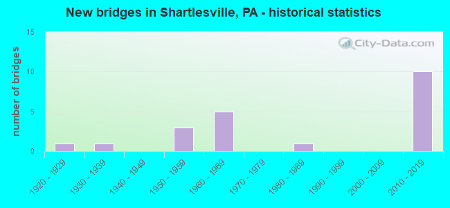
- New bridges - historical statistics
- 11920-1929
- 11930-1939
- 31950-1959
- 51960-1969
- 11980-1989
- 102010-2019

- Reconstructed bridges - Historical Statistics
- 11920-1929
- 01930-1939
- 01940-1949
- 01950-1959
- 01960-1969
- 11970-1979


- Bridge Condition - Deck
- 25.0%Excellent
- 12.5%Very good
- 12.5%Good
- 25.0%Satisfactory
- 12.5%Fair
- 12.5%Poor

- Bridge Condition - Superstructure
- 25.0%Excellent
- 25.0%Very good
- 25.0%Satisfactory
- 12.5%Fair
- 12.5%Poor

- Bridge Condition - Substructure
- 25.0%Excellent
- 12.5%Very good
- 12.5%Good
- 25.0%Satisfactory
- 25.0%Fair

- Bridge Condition - Channel
- 14.3%Very good
- 28.6%Satisfactory
- 42.9%Fair
- 14.3%Poor

- Bridge Condition - Culverts
- 33.3%Very good
- 66.7%Satisfactory
Find on map >> Show street view
Structure Number: 4646, Location: 1 MI.W.OF SHARTLESVILLE (Lat: 40.512203, Lng: -76.126647), Route carried "on" structure: Interstate 78, Year Built: 1954, Year Reconstructed: 1977, Status: Open, Structure Length: 0.73m (2.40ft), Average Daily Traffic: 36,296 (year 2022), Truck Traffic: 35%, Average Future Daily Traffic: 44,209 (year 2032), Design Load: HS 20+Mod, Features Intersected: NORTHKILL CREEK
Minimum Vertical Clearance: 30+ m (98+ ft), Kilometerpoint: 21.976, Lanes on structure: 4, Base Highway Network: Yes, Owner: State Highway Agency, Approaching Roadway Width: 28.0m (91.9ft), Skew: 30 degrees, Material/Design: Concrete, Design/Construction: Culvert, Number Of Spans In Main Unit: 1, Length of Maximum Span: 7.3m (24.0ft)
Condition: Channel: Fair, Culverts: Satisfactory, Operating Rating: 45.4 metric tons, Method Used To Determine Operating Rating: Load Factor (LF), Inventory Rating: 27.2 metric tons, Method Used To Determine Inventory Rating: Load Factor (LF), Structural Evaluation: Equal to present minimum criteria, Waterway Adequacy: Superior to present desirable criteria, Approach Roadway Alignment: Equal to present desirable criteria, Length Of Structure Improvement: 1.40m (4.59ft), Designated Inspection Frequency: Every 24 months, Inspection Date: April 2021
Find on map >> Show street view
Structure Number: 465, Location: 2 MI.E.OF SHARTLESVILLE (Lat: 40.527094, Lng: -76.078042), Route carried "on" structure: State highway , Year Built: 1961, Status: Open, Structure Length: 4.79m (15.72ft), Average Daily Traffic: 160 (year 2021), Truck Traffic: 7%, Average Future Daily Traffic: 181 (year 2032), Design Load: HS 20, Features Intersected: SR 78 (LR141), Facility Carried by Structure: SR4047(MILL RD.)
Minimum Vertical Clearance: 30+ m (98+ ft), Kilometerpoint: 0.000, Lanes on structure: 2, Lanes under structure: 8, Owner: State Highway Agency, Approaching Roadway Width: 5.5m (18.0ft), Material/Design: Prestressed concrete, Design/Construction: Box Beam or Girders - Multiple, Number Of Spans In Main Unit: 1, Number Of Approach Spans: 2, Length of Maximum Span: 27.4m (89.9ft), Curb-To-Curb Width: 8.5m (27.9ft), Out-to-Out Width: 10.2m (33.5ft)
Condition: Deck: Satisfactory, Superstructure: Satisfactory, Substructure: Fair, Operating Rating: 76.2 metric tons, Method Used To Determine Operating Rating: Load Factor (LF), Inventory Rating: 45.4 metric tons, Method Used To Determine Inventory Rating: Load Factor (LF), Structural Evaluation: Somewhat better than minimum adequacy, Deck Geometry: Equal to present minimum criteria, Underclear: Equal to present minimum criteria, Approach Roadway Alignment: Better than present minimum criteria, Length Of Structure Improvement: 5.70m (18.70ft), Designated Inspection Frequency: Every 24 months, Inspection Date: July 2021, Deck Structure Type: Concrete Cast-file-Place, Wearing Surface/Protective System: Wearing Surface: Monolithic Concrete
Find on map >> Show street view
Structure Number: 4653, Location: 3 MI.E.OF SHARTLESVILLE (Lat: 40.535800, Lng: -76.054575), Route carried "on" structure: Interstate 78, Year Built: 1956, Status: Open, Structure Length: 0.64m (2.10ft), Average Daily Traffic: 35,468 (year 2021), Truck Traffic: 38%, Average Future Daily Traffic: 44,209 (year 2032), Design Load: HS 20+Mod, Features Intersected: TRIB.MILL CREEK
Minimum Vertical Clearance: 30+ m (98+ ft), Kilometerpoint: 28.436, Lanes on structure: 4, Base Highway Network: Yes, Owner: State Highway Agency, Approaching Roadway Width: 27.4m (89.9ft), Skew: 33 degrees, Material/Design: Concrete, Design/Construction: Culvert, Number Of Spans In Main Unit: 1, Length of Maximum Span: 6.4m (21.0ft)
Condition: Channel: Fair, Culverts: Satisfactory, Operating Rating: 89.8 metric tons, Method Used To Determine Operating Rating: Field evaluation and documented engineering judgment, Inventory Rating: 89.8 metric tons, Method Used To Determine Inventory Rating: Field evaluation and documented engineering judgment, Structural Evaluation: Equal to present minimum criteria, Waterway Adequacy: Superior to present desirable criteria, Approach Roadway Alignment: Equal to present desirable criteria, Length Of Structure Improvement: 1.20m (3.94ft), Designated Inspection Frequency: Every 24 months, Inspection Date: April 2021
Find on map >> Show street view
Structure Number: 5238, Location: SHARTLESVILLE ROAD (Lat: 40.482133, Lng: -76.111172), Route carried "on" structure: State highway , Year Built: 1966, Status: Open, Structure Length: 1.52m (4.99ft), Average Daily Traffic: 1,961 (year 2020), Truck Traffic: 5%, Average Future Daily Traffic: 1,667 (year 2032), Design Load: HS 20, Features Intersected: NORTHKILL CREEK, Facility Carried by Structure: SR 4011(LR 06017)
Minimum Vertical Clearance: 30+ m (98+ ft), Kilometerpoint: 5.198, Lanes on structure: 2, Owner: State Highway Agency, Approaching Roadway Width: 8.2m (26.9ft), Skew: 2 degrees, Material/Design: Prestressed concrete, Design/Construction: Box Beam or Girders - Single/Spread, Number Of Spans In Main Unit: 1, Length of Maximum Span: 14.6m (47.9ft), Curb-To-Curb Width: 9.8m (32.2ft), Out-to-Out Width: 11.4m (37.4ft)
Condition: Deck: Satisfactory, Superstructure: Very good, Substructure: Satisfactory, Channel: Fair, Inventory Rating: 49.0 metric tons, Method Used To Determine Inventory Rating: Load Factor (LF), Structural Evaluation: Equal to present minimum criteria, Deck Geometry: Somewhat better than minimum adequacy, Waterway Adequacy: Superior to present desirable criteria, Approach Roadway Alignment: Equal to present desirable criteria, Length Of Structure Improvement: 2.20m (7.22ft), Designated Inspection Frequency: Every 48 months, Inspection Date: August 2019, Deck Structure Type: Concrete Cast-file-Place, Wearing Surface/Protective System: Wearing Surface: Monolithic Concrete
Find on map >> Show street view
Structure Number: 47409, Location: Northkill & S. Northkill (Lat: 40.509261, Lng: -76.124889), Route carried "on" structure: State highway , Year Built: 1922, Year Reconstructed: 1933, Status: Open, Structure Length: 0.88m (2.89ft), Average Daily Traffic: 909 (year 2022), Truck Traffic: 11%, Average Future Daily Traffic: 1,424 (year 2039), Design Load: H 20, Features Intersected: Trib to Northkill Ck, Facility Carried by Structure: OLD ROUTE 22
Minimum Vertical Clearance: 30+ m (98+ ft), Kilometerpoint: 5.461, Lanes on structure: 2, Owner: State Highway Agency, Approaching Roadway Width: 7.0m (23.0ft), Skew: 1 degrees, Material/Design: Concrete, Design/Construction: Tee Beam, Number Of Spans In Main Unit: 1, Length of Maximum Span: 7.9m (25.9ft), Curb or Sidewalk Widths: Left: 0.2m (0.7ft), Right: 0.2m (0.7ft), Curb-To-Curb Width: 9.7m (31.8ft), Out-to-Out Width: 11.9m (39.0ft)
Condition: Deck: Fair, Superstructure: Fair, Substructure: Fair, Channel: Poor, Operating Rating: 47.2 metric tons, Method Used To Determine Operating Rating: Allowable Stress (AS), Inventory Rating: 27.2 metric tons, Method Used To Determine Inventory Rating: Allowable Stress (AS), Structural Evaluation: Somewhat better than minimum adequacy, Deck Geometry: Equal to present minimum criteria, Waterway Adequacy: Equal to present minimum criteria, Approach Roadway Alignment: Equal to present desirable criteria, Designated Inspection Frequency: Every 24 months, Inspection Date: July 2020, Deck Structure Type: Concrete Cast-file-Place, Wearing Surface/Protective System: Wearing Surface: Bituminous
Find on map >> Show street view
Structure Number: 47958, Location: EAST OF SHARTLESVILLE (Lat: 40.507192, Lng: -76.064678), Route carried "on" structure: City street , Year Built: 1989, Status: Open, Structure Length: 0.85m (2.79ft), Average Daily Traffic: 75 (year 2013), Average Future Daily Traffic: 100 (year 2023), Design Load: HS 25 or greater, Features Intersected: LESHER RUN, Facility Carried by Structure: SKYLINE DRIVE
Minimum Vertical Clearance: 30+ m (98+ ft), Kilometerpoint: 0.000, Lanes on structure: 2, Owner: Town or Township Highway Agency, Approaching Roadway Width: 5.5m (18.0ft), Skew: 4 degrees, Material/Design: Prestressed concrete, Design/Construction: Box Beam or Girders - Multiple, Number Of Spans In Main Unit: 1, Length of Maximum Span: 8.2m (26.9ft), Curb or Sidewalk Widths: Left: 0.2m (0.7ft), Right: 0.2m (0.7ft), Curb-To-Curb Width: 8.8m (28.9ft), Out-to-Out Width: 9.8m (32.2ft)
Condition: Deck: Poor, Superstructure: Poor, Substructure: Satisfactory, Channel: Satisfactory, Operating Rating: 68.9 metric tons, Method Used To Determine Operating Rating: Load Factor (LF), Inventory Rating: 40.8 metric tons, Method Used To Determine Inventory Rating: Load Factor (LF), Structural Evaluation: Meets minimum limits, Deck Geometry: Better than present minimum criteria, Waterway Adequacy: Better than present minimum criteria, Approach Roadway Alignment: Equal to present desirable criteria, Designated Inspection Frequency: Every 24 months, Inspection Date: November 2021, Deck Structure Type: Other, Wearing Surface/Protective System: Wearing Surface: Bituminous, Membrane: Preformed Fabric
Find on map >> Show street view
Structure Number: 47959, Location: EAST OF SHARTLESVILLE (Lat: 40.524878, Lng: -76.062900), Route carried "on" structure: City street , Year Built: 1939, Status: Open, Structure Length: 0.98m (3.22ft), Average Daily Traffic: 50 (year 2013), Truck Traffic: 1%, Average Future Daily Traffic: 75 (year 2023), Design Load: H 20, Features Intersected: MILL CREEK, Facility Carried by Structure: MILL HILL ROAD
Minimum Vertical Clearance: 30+ m (98+ ft), Kilometerpoint: 0.000, Lanes on structure: 2, Owner: Town or Township Highway Agency, Approaching Roadway Width: 6.7m (22.0ft), Material/Design: Concrete, Design/Construction: Tee Beam, Number Of Spans In Main Unit: 1, Length of Maximum Span: 9.4m (30.8ft), Curb-To-Curb Width: 7.3m (24.0ft), Out-to-Out Width: 8.4m (27.6ft)
Condition: Deck: Good, Superstructure: Satisfactory, Substructure: Good, Channel: Satisfactory, Operating Rating: 79.8 metric tons, Method Used To Determine Operating Rating: Field evaluation and documented engineering judgment, Inventory Rating: 47.2 metric tons, Method Used To Determine Inventory Rating: Field evaluation and documented engineering judgment, Structural Evaluation: Equal to present minimum criteria, Deck Geometry: Equal to present minimum criteria, Waterway Adequacy: Superior to present desirable criteria, Approach Roadway Alignment: Equal to present desirable criteria, Designated Inspection Frequency: Every 24 months, Inspection Date: November 2021, Deck Structure Type: Concrete Cast-file-Place, Wearing Surface/Protective System: Wearing Surface: Bituminous
Find on map >> Show street view
Structure Number: 53511, Location: Power Drive over I-78 (Lat: 40.506667, Lng: -76.153333), Route carried "on" structure: State highway , Year Built: 2016, Status: Open, Structure Length: 3.26m (10.70ft), Average Daily Traffic: 199 (year 2021), Truck Traffic: 2%, Average Future Daily Traffic: 323 (year 2031), Design Load: HL 93, Features Intersected: I-78, Facility Carried by Structure: SR 4043
Minimum Vertical Clearance: 30+ m (98+ ft), Kilometerpoint: 0.000, Lanes on structure: 2, Lanes under structure: 4, Owner: State Highway Agency, Approaching Roadway Width: 5.5m (18.0ft), Material/Design: Prestressed concrete, Design/Construction: Stringer/Multi-beam, Number Of Spans In Main Unit: 1, Length of Maximum Span: 31.4m (103.0ft), Curb or Sidewalk Widths: Left: 0.2m (0.7ft), Right: 0.2m (0.7ft), Curb-To-Curb Width: 8.5m (27.9ft), Out-to-Out Width: 9.7m (31.8ft)
Condition: Deck: Very good, Superstructure: Very good, Substructure: Very good, Operating Rating: 48.6 metric tons, Method Used To Determine Operating Rating: Assigned ratings based on Load and Resistance Factor Design (LRFD) reported by rating factor (RF) using HL93 loadings, Inventory Rating: 36.3 metric tons, Method Used To Determine Inventory Rating: Assigned ratings based on Load and Resistance Factor Design (LRFD) reported by rating factor (RF) using HL93 loadings, Structural Evaluation: Equal to present desirable criteria, Deck Geometry: Equal to present minimum criteria, Underclear: Equal to present minimum criteria, Approach Roadway Alignment: Equal to present desirable criteria, Designated Inspection Frequency: Every 48 months, Inspection Date: October 2018, Deck Structure Type: Concrete Cast-file-Place, Wearing Surface/Protective System: Wearing Surface: Latex Concrete, Deck Protection: Epoxy Coated Reinforcing
Find on map >> Show street view
Structure Number: 53717, Location: Shartlesville Exit (Lat: 40.515703, Lng: -76.110894), Route carried "on" structure: State highway , Year Built: 2017, Status: Open, Structure Length: 3.41m (11.19ft), Average Daily Traffic: 3,710 (year 2022), Truck Traffic: 7%, Average Future Daily Traffic: 5,523 (year 2032), Design Load: HL 93, Features Intersected: I-78 (LR 141), Facility Carried by Structure: SR 4011 (LR 06017)
Minimum Vertical Clearance: 30+ m (98+ ft), Kilometerpoint: 8.935, Lanes on structure: 2, Lanes under structure: 4, Owner: State Highway Agency, Approaching Roadway Width: 10.1m (33.1ft), Skew: 1 degrees, Material/Design: Prestressed concrete, Design/Construction: Stringer/Multi-beam, Number Of Spans In Main Unit: 1, Length of Maximum Span: 33.5m (109.9ft), Curb or Sidewalk Widths: Left: 0.2m (0.7ft), Right: 0.2m (0.7ft), Curb-To-Curb Width: 16.5m (54.1ft), Out-to-Out Width: 17.6m (57.7ft)
Condition: Deck: Excellent, Superstructure: Excellent, Substructure: Excellent, Operating Rating: 52.5 metric tons, Method Used To Determine Operating Rating: Assigned ratings based on Load and Resistance Factor Design (LRFD) reported by rating factor (RF) using HL93 loadings, Inventory Rating: 38.9 metric tons, Method Used To Determine Inventory Rating: Assigned ratings based on Load and Resistance Factor Design (LRFD) reported by rating factor (RF) using HL93 loadings, Structural Evaluation: Superior to present desirable criteria, Deck Geometry: Superior to present desirable criteria, Underclear: Equal to present minimum criteria, Approach Roadway Alignment: Equal to present desirable criteria, Designated Inspection Frequency: Every 48 months, Inspection Date: December 2019, Deck Structure Type: Concrete Cast-file-Place, Wearing Surface/Protective System: Wearing Surface: Latex Concrete, Deck Protection: Epoxy Coated Reinforcing
Find on map >> Show street view
Structure Number: 53719, Location: Northkill Rd over I-78 (Lat: 40.511958, Lng: -76.127764), Route carried "on" structure: State highway , Year Built: 2017, Status: Open, Structure Length: 3.26m (10.70ft), Average Daily Traffic: 475 (year 2021), Truck Traffic: 17%, Average Future Daily Traffic: 226 (year 2032), Design Load: HL 93, Features Intersected: I-78 (LR 141), Facility Carried by Structure: SR4045 (Northkill)
Minimum Vertical Clearance: 30+ m (98+ ft), Kilometerpoint: 0.000, Lanes on structure: 2, Lanes under structure: 4, Owner: State Highway Agency, Approaching Roadway Width: 8.5m (27.9ft), Material/Design: Prestressed concrete, Design/Construction: Stringer/Multi-beam, Number Of Spans In Main Unit: 1, Length of Maximum Span: 31.7m (104.0ft), Curb or Sidewalk Widths: Left: 0.2m (0.7ft), Right: 0.2m (0.7ft), Curb-To-Curb Width: 8.5m (27.9ft), Out-to-Out Width: 9.6m (31.5ft)
Condition: Deck: Excellent, Superstructure: Excellent, Substructure: Excellent, Operating Rating: 47.0 metric tons, Method Used To Determine Operating Rating: Assigned ratings based on Load and Resistance Factor Design (LRFD) reported by rating factor (RF) using HL93 loadings, Inventory Rating: 35.3 metric tons, Method Used To Determine Inventory Rating: Assigned ratings based on Load and Resistance Factor Design (LRFD) reported by rating factor (RF) using HL93 loadings, Structural Evaluation: Superior to present desirable criteria, Deck Geometry: Somewhat better than minimum adequacy, Underclear: Equal to present minimum criteria, Approach Roadway Alignment: Equal to present desirable criteria, Designated Inspection Frequency: Every 48 months, Inspection Date: December 2019, Deck Structure Type: Concrete Cast-file-Place, Wearing Surface/Protective System: Wearing Surface: Latex Concrete, Deck Protection: Epoxy Coated Reinforcing
Find on map >> Show street view
Structure Number: 5589, Location: 3 M. SW OF BERNE (Lat: 40.495661, Lng: -76.051056), Route carried "on" structure: State highway , Year Built: 2018, Status: Open, Structure Length: 0.67m (2.20ft), Average Daily Traffic: 387 (year 2020), Truck Traffic: 11%, Average Future Daily Traffic: 329 (year 2039), Design Load: HL 93, Features Intersected: LESHER RUN, Facility Carried by Structure: SR 4015 (LR 06193)
Minimum Vertical Clearance: 30+ m (98+ ft), Kilometerpoint: 2.506, Lanes on structure: 2, Owner: State Highway Agency, Approaching Roadway Width: 4.9m (16.1ft), Skew: 3 degrees, Material/Design: Concrete, Design/Construction: Culvert, Number Of Spans In Main Unit: 1, Length of Maximum Span: 6.7m (22.0ft)
Condition: Channel: Very good, Culverts: Very good, Operating Rating: 59.6 metric tons, Method Used To Determine Operating Rating: Assigned ratings based on Load and Resistance Factor Design (LRFD) reported by rating factor (RF) using HL93 loadings, Inventory Rating: 37.6 metric tons, Method Used To Determine Inventory Rating: Assigned ratings based on Load and Resistance Factor Design (LRFD) reported by rating factor (RF) using HL93 loadings, Structural Evaluation: Equal to present desirable criteria, Waterway Adequacy: Equal to present minimum criteria, Approach Roadway Alignment: Equal to present desirable criteria, Designated Inspection Frequency: Every 48 months, Inspection Date: September 2020
Find on map >> Show street view
Structure Number: 4648, Location: I-78 OVER SCHOOL HOUSE RD (Lat: 40.520425, Lng: -76.095669), Route carried "under" structure: City street T566, Year Built: 1955, Structure Length: 0. m, Average Daily Traffic: 200 (year 1992), Truck Traffic: 1%, Features Intersected: T-566(SCHOOL HOUSE ROAD), Facility Carried by Structure: SR 78 (LR 141)
Minimum Vertical Clearance: 4.16m (13.65ft), Kilometerpoint: 0.000, Lanes on structure: 4, Lanes under structure: 2, Material/Design: Concrete, Design/Construction: Tee Beam, Length of Maximum Span: 8.2m (26.9ft)
Find on map >> Show street view
Structure Number: 465, Location: 2 MI.E.OF SHARTLESVILLE (Lat: 40.527094, Lng: -76.078042), Route carried "under" structure: Interstate 78, Year Built: 1961, Structure Length: 0. m, Average Daily Traffic: 17,129 (year 2021), Truck Traffic: 40%, Features Intersected: SR 78 (LR141), Facility Carried by Structure: SR4047(MILL RD.)
Minimum Vertical Clearance: 5.06m (16.60ft), Kilometerpoint: 26.012, Lanes on structure: 2, Lanes under structure: 4, Material/Design: Prestressed concrete, Design/Construction: Box Beam or Girders - Multiple, Length of Maximum Span: 27.4m (89.9ft)
Find on map >> Show street view
Structure Number: 465, Location: 2 MI.E.OF SHARTLESVILLE (Lat: 40.527094, Lng: -76.078042), Route carried "under" structure: Interstate 78, Year Built: 1961, Structure Length: 0. m, Average Daily Traffic: 18,339 (year 2021), Truck Traffic: 35%, Features Intersected: SR 78 (LR141), Facility Carried by Structure: SR4047(MILL RD.)
Minimum Vertical Clearance: 5.09m (16.70ft), Kilometerpoint: 26.002, Lanes on structure: 2, Lanes under structure: 4, Material/Design: Prestressed concrete, Design/Construction: Box Beam or Girders - Multiple, Length of Maximum Span: 27.4m (89.9ft)
Find on map >> Show street view
Structure Number: 4652, Location: I-78 OVER TILDEN RD. (Lat: 40.535706, Lng: -76.054822), Route carried "under" structure: City street T740, Year Built: 1962, Structure Length: 0. m, Average Daily Traffic: 200 (year 1992), Truck Traffic: 1%, Features Intersected: TWP.RD 740 (TILDEN RD.), Facility Carried by Structure: SR 78 (LR 141)
Minimum Vertical Clearance: 4.42m (14.50ft), Kilometerpoint: 0.000, Lanes on structure: 4, Lanes under structure: 2, Material/Design: Prestressed concrete, Design/Construction: Box Beam or Girders - Multiple, Length of Maximum Span: 11.0m (36.1ft)
Find on map >> Show street view
Structure Number: 53511, Location: Power Drive over I-78 (Lat: 40.506667, Lng: -76.153333), Route carried "under" structure: Interstate 78, Year Built: 2016, Structure Length: 0. m, Average Daily Traffic: 18,761 (year 2022), Truck Traffic: 34%, Features Intersected: I-78, Facility Carried by Structure: SR 4043
Minimum Vertical Clearance: 5.09m (16.70ft), Kilometerpoint: 18.752, Lanes on structure: 2, Lanes under structure: 2, Material/Design: Prestressed concrete, Design/Construction: Stringer/Multi-beam, Length of Maximum Span: 31.4m (103.0ft)
Find on map >> Show street view
Structure Number: 53511, Location: Power Drive over I-78 (Lat: 40.506667, Lng: -76.153333), Route carried "under" structure: Interstate 78, Year Built: 2016, Structure Length: 0. m, Average Daily Traffic: 17,535 (year 2022), Truck Traffic: 36%, Features Intersected: I-78, Facility Carried by Structure: SR 4043
Minimum Vertical Clearance: 5.15m (16.90ft), Kilometerpoint: 18.750, Lanes on structure: 2, Lanes under structure: 2, Material/Design: Prestressed concrete, Design/Construction: Stringer/Multi-beam, Length of Maximum Span: 31.4m (103.0ft)
Find on map >> Show street view
Structure Number: 53717, Location: Shartlesville Exit (Lat: 40.515703, Lng: -76.110894), Route carried "under" structure: Interstate 78, Year Built: 2017, Structure Length: 0. m, Average Daily Traffic: 17,129 (year 2021), Truck Traffic: 40%, Features Intersected: I-78 (LR 141), Facility Carried by Structure: SR 4011 (LR 06017)
Minimum Vertical Clearance: 5.06m (16.60ft), Kilometerpoint: 22.783, Lanes on structure: 2, Lanes under structure: 2, Material/Design: Prestressed concrete, Design/Construction: Stringer/Multi-beam, Length of Maximum Span: 33.5m (109.9ft)
Find on map >> Show street view
Structure Number: 53717, Location: Shartlesville Exit (Lat: 40.515703, Lng: -76.110894), Route carried "under" structure: Interstate 78, Year Built: 2017, Structure Length: 0. m, Average Daily Traffic: 18,339 (year 2021), Truck Traffic: 35%, Features Intersected: I-78 (LR 141), Facility Carried by Structure: SR 4011 (LR 06017)
Minimum Vertical Clearance: 5.15m (16.90ft), Kilometerpoint: 22.779, Lanes on structure: 2, Lanes under structure: 2, Material/Design: Prestressed concrete, Design/Construction: Stringer/Multi-beam, Length of Maximum Span: 33.5m (109.9ft)
Find on map >> Show street view
Structure Number: 53719, Location: Northkill Rd over I-78 (Lat: 40.511958, Lng: -76.127764), Route carried "under" structure: Interstate 78, Year Built: 2017, Structure Length: 0. m, Average Daily Traffic: 17,535 (year 2022), Truck Traffic: 36%, Features Intersected: I-78 (LR 141), Facility Carried by Structure: SR4045 (Northkill)
Minimum Vertical Clearance: 5.18m (16.99ft), Kilometerpoint: 21.976, Lanes on structure: 2, Lanes under structure: 2, Material/Design: Prestressed concrete, Design/Construction: Stringer/Multi-beam, Length of Maximum Span: 31.7m (104.0ft)
Find on map >> Show street view
Structure Number: 53719, Location: Northkill Rd over I-78 (Lat: 40.511958, Lng: -76.127764), Route carried "under" structure: Interstate 78, Year Built: 2017, Structure Length: 0. m, Average Daily Traffic: 18,761 (year 2022), Truck Traffic: 34%, Features Intersected: I-78 (LR 141), Facility Carried by Structure: SR4045 (Northkill)
Minimum Vertical Clearance: 5.09m (16.70ft), Kilometerpoint: 21.977, Lanes on structure: 2, Lanes under structure: 2, Material/Design: Prestressed concrete, Design/Construction: Stringer/Multi-beam, Length of Maximum Span: 31.7m (104.0ft)