Bridge Statistics for Sharpsburg, Pennsylvania (PA)
Condition, Traffic, Stress, Structural Evaluation, Project Costs
- National Bridge Inventory (NBI) Statistics
- 18Number of bridges
- 266ft / 81.1mTotal length
- $3,201,000Total costs
- 239,476Total average daily traffic
- 19,729Total average daily truck traffic
- National Bridge Inventory (NBI) Registered Bridges for Sharpsburg
- No street view available for this location
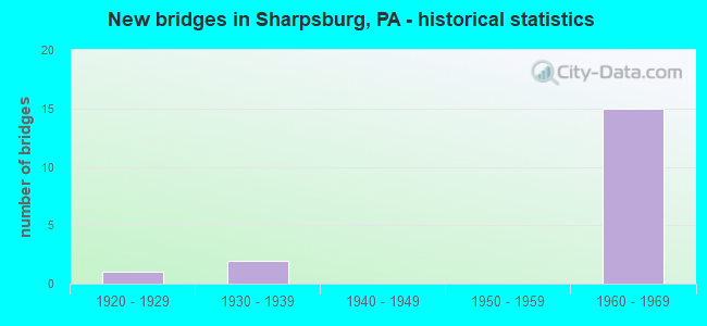
- New bridges - historical statistics
- 11920-1929
- 21930-1939
- 151960-1969

- Reconstructed bridges - Historical Statistics
- 21970-1979
- 21980-1989
- 21990-1999
- 22000-2009


- Bridge Condition - Deck
- 12.5%Very good
- 75.0%Good
- 12.5%Poor

- Bridge Condition - Superstructure
- 12.5%Very good
- 50.0%Good
- 25.0%Satisfactory
- 12.5%Poor

- Bridge Condition - Substructure
- 50.0%Good
- 25.0%Satisfactory
- 25.0%Fair

- Bridge Condition - Channel
- 33.3%Satisfactory
- 66.7%Fair
Find on map >> Show street view
Structure Number: 61, Location: 1 MI. S. OF BIGLERVILLE (Lat: 39.910356, Lng: -77.248392), Route carried "on" structure: State highway 34, Year Built: 1920, Year Reconstructed: 1981, Status: Open, Structure Length: 2.80m (9.19ft), Average Daily Traffic: 4,233 (year 2021), Truck Traffic: 7%, Average Future Daily Traffic: 8,396 (year 2032), Features Intersected: CONEWAGO CREEK
Minimum Vertical Clearance: 30+ m (98+ ft), Kilometerpoint: 8.330, Lanes on structure: 2, Base Highway Network: Yes, Owner: State Highway Agency, Approaching Roadway Width: 8.8m (28.9ft), Skew: 4 degrees, Material/Design: Concrete, Design/Construction: Tee Beam, Number Of Spans In Main Unit: 2, Length of Maximum Span: 12.5m (41.0ft), Curb or Sidewalk Widths: Left: 0.2m (0.7ft), Right: 0.2m (0.7ft), Curb-To-Curb Width: 10.5m (34.4ft), Out-to-Out Width: 11.6m (38.1ft)
Condition: Deck: Poor, Superstructure: Poor, Substructure: Fair, Channel: Satisfactory, Operating Rating: 49.0 metric tons, Method Used To Determine Operating Rating: Field evaluation and documented engineering judgment, Inventory Rating: 32.7 metric tons, Method Used To Determine Inventory Rating: Field evaluation and documented engineering judgment, Structural Evaluation: Meets minimum limits, Deck Geometry: Somewhat better than minimum adequacy, Waterway Adequacy: Equal to present minimum criteria, Approach Roadway Alignment: Equal to present desirable criteria, Length Of Structure Improvement: 3.60m (11.81ft), Designated Inspection Frequency: Every 24 months, Inspection Date: May 2021, Bridge Improvement Cost: $31,000, Roadway Improvement Cost: $92,000, Total Project Cost: $420,000, Deck Structure Type: Concrete Cast-file-Place, Wearing Surface/Protective System: Wearing Surface: Bituminous
Find on map >> Show street view
Structure Number: 603, Location: 1.0 MI W OF HIGHLAND PK (Lat: 40.497231, Lng: -79.935350), Route carried "on" structure: State highway 28, Year Built: 1963, Year Reconstructed: 2000, Status: Open, Structure Length: 4.75m (15.58ft), Average Daily Traffic: 30,704 (year 2022), Truck Traffic: 7%, Average Future Daily Traffic: 27,086 (year 2032), Design Load: HS 20, Features Intersected: RAVINE ST, Facility Carried by Structure: ALLEGHENY VAL EXPY
Minimum Vertical Clearance: 30+ m (98+ ft), Kilometerpoint: 7.725, Lanes on structure: 3, Lanes under structure: 2, Base Highway Network: Yes, Owner: State Highway Agency, Approaching Roadway Width: 15.2m (49.9ft), Material/Design: Steel continuous, Design/Construction: Stringer/Multi-beam, Number Of Spans In Main Unit: 3, Length of Maximum Span: 18.9m (62.0ft), Curb or Sidewalk Widths: Left: 0.2m (0.7ft), Right: 0.2m (0.7ft), Curb-To-Curb Width: 15.2m (49.9ft), Out-to-Out Width: 16.1m (52.8ft)
Condition: Deck: Good, Superstructure: Good, Substructure: Satisfactory, Inventory Rating: 62.6 metric tons, Method Used To Determine Inventory Rating: Load Factor (LF), Structural Evaluation: Equal to present minimum criteria, Deck Geometry: Meets minimum limits, Underclear: Meets minimum limits, Approach Roadway Alignment: Equal to present desirable criteria, Length Of Structure Improvement: 4.80m (15.75ft), Designated Inspection Frequency: Every 24 months, Inspection Date: June 2021, Deck Structure Type: Concrete Cast-file-Place, Wearing Surface/Protective System: Wearing Surface: Monolithic Concrete, Deck Protection: Epoxy Coated Reinforcing
Find on map >> Show street view
Structure Number: 605, Location: 3/4 MI.WEST OF HIGH.PARK (Lat: 40.497356, Lng: -79.925083), Route carried "on" structure: State highway 28, Year Built: 1963, Year Reconstructed: 1977, Status: Open, Structure Length: 15.91m (52.20ft), Average Daily Traffic: 30,912 (year 2022), Truck Traffic: 15%, Average Future Daily Traffic: 25,741 (year 2032), Design Load: HS 20, Features Intersected: KITTANNING PIKE,CREEK
Minimum Vertical Clearance: 30+ m (98+ ft), Kilometerpoint: 8.719, Lanes on structure: 2, Lanes under structure: 2, Base Highway Network: Yes, Owner: State Highway Agency, Approaching Roadway Width: 11.0m (36.1ft), Skew: 12 degrees, Material/Design: Steel, Design/Construction: Stringer/Multi-beam, Number Of Spans In Main Unit: 4, Number Of Approach Spans: 2, Length of Maximum Span: 29.3m (96.1ft), Curb or Sidewalk Widths: Left: 0.2m (0.7ft), Right: 0.2m (0.7ft), Curb-To-Curb Width: 11.0m (36.1ft), Out-to-Out Width: 12.2m (40.0ft)
Condition: Deck: Good, Superstructure: Good, Substructure: Good, Channel: Fair, Operating Rating: 82.6 metric tons, Method Used To Determine Operating Rating: Load Factor (LF), Inventory Rating: 49.9 metric tons, Method Used To Determine Inventory Rating: Load Factor (LF), Structural Evaluation: Better than present minimum criteria, Deck Geometry: Somewhat better than minimum adequacy, Underclear: Equal to present desirable criteria, Waterway Adequacy: Superior to present desirable criteria, Approach Roadway Alignment: Equal to present desirable criteria, Length Of Structure Improvement: 15.90m (52.17ft), Designated Inspection Frequency: Every 24 months, Inspection Date: June 2021, Bridge Improvement Cost: $72,000, Roadway Improvement Cost: $211,000, Total Project Cost: $969,000, Deck Structure Type: Concrete Cast-file-Place, Wearing Surface/Protective System: Wearing Surface: Latex Concrete, Deck Protection: Epoxy Coated Reinforcing
Find on map >> Show street view
Structure Number: 607, Location: RT 28 SB OVER KITTANNING (Lat: 40.497547, Lng: -79.925297), Route carried "on" structure: State highway 28, Year Built: 1963, Year Reconstructed: 2001, Status: Open, Structure Length: 17.37m (56.99ft), Average Daily Traffic: 30,704 (year 2022), Truck Traffic: 7%, Average Future Daily Traffic: 27,086 (year 2032), Design Load: HS 20, Features Intersected: KITTANNING PIKE,SEITZ RU
Minimum Vertical Clearance: 30+ m (98+ ft), Kilometerpoint: 8.732, Lanes on structure: 2, Lanes under structure: 2, Base Highway Network: Yes, Owner: State Highway Agency, Approaching Roadway Width: 11.0m (36.1ft), Skew: 12 degrees, Material/Design: Prestressed concrete, Design/Construction: Stringer/Multi-beam, Number Of Spans In Main Unit: 6, Length of Maximum Span: 29.9m (98.1ft), Curb or Sidewalk Widths: Left: 0.2m (0.7ft), Right: 0.2m (0.7ft), Curb-To-Curb Width: 11.1m (36.4ft), Out-to-Out Width: 11.9m (39.0ft)
Condition: Deck: Good, Superstructure: Good, Substructure: Good, Channel: Fair, Inventory Rating: 18.1 metric tons, Method Used To Determine Inventory Rating: Load Factor (LF), Structural Evaluation: Meets minimum limits, Deck Geometry: Somewhat better than minimum adequacy, Underclear: Meets minimum limits, Waterway Adequacy: Superior to present desirable criteria, Approach Roadway Alignment: Equal to present desirable criteria, Length Of Structure Improvement: 17.40m (57.09ft), Designated Inspection Frequency: Every 24 months, Inspection Date: June 2021, Bridge Improvement Cost: $65,000, Roadway Improvement Cost: $192,000, Total Project Cost: $879,000, Deck Structure Type: Concrete Cast-file-Place, Wearing Surface/Protective System: Wearing Surface: Epoxy Overlay, Deck Protection: Epoxy Coated Reinforcing
Find on map >> Show street view
Structure Number: 61, Location: N.B. @ SCOUT RESERVATION (Lat: 40.495825, Lng: -79.911711), Route carried "on" structure: State highway 28, Year Built: 1963, Year Reconstructed: 2009, Status: Open, Structure Length: 2.87m (9.42ft), Average Daily Traffic: 30,912 (year 2022), Truck Traffic: 15%, Average Future Daily Traffic: 25,741 (year 2032), Design Load: HL 93, Features Intersected: SCOUT RESERVATION ROAD
Minimum Vertical Clearance: 30+ m (98+ ft), Kilometerpoint: 9.540, Lanes on structure: 2, Lanes under structure: 2, Base Highway Network: Yes, Owner: State Highway Agency, Approaching Roadway Width: 15.2m (49.9ft), Material/Design: Steel, Design/Construction: Stringer/Multi-beam, Number Of Spans In Main Unit: 1, Length of Maximum Span: 27.4m (89.9ft), Curb-To-Curb Width: 15.2m (49.9ft), Out-to-Out Width: 16.5m (54.1ft)
Condition: Deck: Very good, Superstructure: Good, Substructure: Good, Operating Rating: 91.6 metric tons, Method Used To Determine Operating Rating: Load and Resistance Factor (LRFR), Inventory Rating: 70.8 metric tons, Method Used To Determine Inventory Rating: Load and Resistance Factor (LRFR), Structural Evaluation: Better than present minimum criteria, Deck Geometry: Superior to present desirable criteria, Underclear: Meets minimum limits, Approach Roadway Alignment: Better than present minimum criteria, Length Of Structure Improvement: 2.90m (9.51ft), Designated Inspection Frequency: Every 48 months, Inspection Date: April 2018, Bridge Improvement Cost: $28,000, Roadway Improvement Cost: $81,000, Total Project Cost: $372,000, Deck Structure Type: Concrete Cast-file-Place, Wearing Surface/Protective System: Wearing Surface: Monolithic Concrete, Deck Protection: Epoxy Coated Reinforcing
Find on map >> Show street view
Structure Number: 612, Location: SHARPSBURG O/SCOUT RES.RD (Lat: 40.496233, Lng: -79.912817), Route carried "on" structure: State highway 28, Year Built: 1963, Year Reconstructed: 2001, Status: Open, Structure Length: 4.82m (15.81ft), Average Daily Traffic: 30,704 (year 2022), Truck Traffic: 7%, Average Future Daily Traffic: 27,086 (year 2032), Design Load: HS 20, Features Intersected: SCOUT RESERVATION ROAD
Minimum Vertical Clearance: 30+ m (98+ ft), Kilometerpoint: 9.476, Lanes on structure: 2, Lanes under structure: 2, Base Highway Network: Yes, Owner: State Highway Agency, Approaching Roadway Width: 11.3m (37.1ft), Material/Design: Prestressed concrete continuous, Design/Construction: Box Beam or Girders - Single/Spread, Number Of Spans In Main Unit: 3, Length of Maximum Span: 15.5m (50.9ft), Curb or Sidewalk Widths: Left: 0.2m (0.7ft), Right: 0.2m (0.7ft), Curb-To-Curb Width: 11.1m (36.4ft), Out-to-Out Width: 11.9m (39.0ft)
Condition: Deck: Good, Superstructure: Very good, Substructure: Good, Operating Rating: 65.3 metric tons, Method Used To Determine Operating Rating: Load and Resistance Factor (LRFR), Inventory Rating: 49.9 metric tons, Method Used To Determine Inventory Rating: Load and Resistance Factor (LRFR), Structural Evaluation: Better than present minimum criteria, Deck Geometry: Somewhat better than minimum adequacy, Underclear: Meets minimum limits, Approach Roadway Alignment: Equal to present desirable criteria, Length Of Structure Improvement: 4.90m (16.08ft), Designated Inspection Frequency: Every 48 months, Inspection Date: April 2018, Deck Structure Type: Concrete Cast-file-Place, Wearing Surface/Protective System: Wearing Surface: Monolithic Concrete, Deck Protection: Epoxy Coated Reinforcing
Find on map >> Show street view
Structure Number: 2848, Location: 28 N.B. RP. TO HIGH.PK.BR (Lat: 40.495061, Lng: -79.909431), Route carried "on" structure: Ramp State highway , Year Built: 1960, Year Reconstructed: 1994, Status: Open, Structure Length: 25.05m (82.19ft), Average Daily Traffic: 8,519 (year 2022), Truck Traffic: 5%, Average Future Daily Traffic: 13,642 (year 2032), Design Load: HS 20, Features Intersected: RAMP C SB, Facility Carried by Structure: RAMP A
Minimum Vertical Clearance: 5.28m (17.32ft), Kilometerpoint: 0.000, Lanes on structure: 1, Lanes under structure: 1, Base Highway Network: Yes, Owner: State Highway Agency, Approaching Roadway Width: 6.4m (21.0ft), Skew: 9 degrees, Material/Design: Steel, Design/Construction: Stringer/Multi-beam, Number Of Spans In Main Unit: 12, Length of Maximum Span: 23.5m (77.1ft), Curb or Sidewalk Widths: Left: 0.2m (0.7ft), Right: 0.2m (0.7ft), Curb-To-Curb Width: 6.4m (21.0ft), Out-to-Out Width: 10.5m (34.4ft)
Condition: Deck: Good, Superstructure: Satisfactory, Substructure: Fair, Operating Rating: 54.4 metric tons, Method Used To Determine Operating Rating: Load Factor (LF), Inventory Rating: 32.7 metric tons, Method Used To Determine Inventory Rating: Load Factor (LF), Structural Evaluation: Somewhat better than minimum adequacy, Deck Geometry: Somewhat better than minimum adequacy, Underclear: Somewhat better than minimum adequacy, Approach Roadway Alignment: Equal to present minimum criteria, Length Of Structure Improvement: 25.10m (82.35ft), Designated Inspection Frequency: Every 24 months, Critical Feature Inspection Frequency: Every 24 months, Inspection Date: June 2020, Critical Feature Inspection Date: June 2020, Bridge Improvement Cost: $42,000, Roadway Improvement Cost: $122,000, Total Project Cost: $561,000, Deck Structure Type: Concrete Cast-file-Place, Wearing Surface/Protective System: Wearing Surface: Monolithic Concrete, Deck Protection: Epoxy Coated Reinforcing
Find on map >> Show street view
Structure Number: 2849, Location: RP.FROM HIGH.PRK.TO 28 SB (Lat: 40.495764, Lng: -79.910383), Route carried "on" structure: Ramp State highway , Year Built: 1960, Year Reconstructed: 1994, Status: Open, Structure Length: 7.56m (24.80ft), Average Daily Traffic: 9,238 (year 2022), Truck Traffic: 4%, Average Future Daily Traffic: 13,460 (year 2032), Design Load: HS 20, Features Intersected: TRAFFIC ROUTE 28 N.B., Facility Carried by Structure: RAMP C RD
Minimum Vertical Clearance: 30+ m (98+ ft), Kilometerpoint: 0.000, Lanes on structure: 1, Lanes under structure: 1, Base Highway Network: Yes, Owner: State Highway Agency, Approaching Roadway Width: 6.7m (22.0ft), Skew: 9 degrees, Material/Design: Steel, Design/Construction: Stringer/Multi-beam, Number Of Spans In Main Unit: 3, Length of Maximum Span: 27.1m (88.9ft), Curb or Sidewalk Widths: Left: 0.2m (0.7ft), Right: 0.2m (0.7ft), Curb-To-Curb Width: 6.9m (22.6ft), Out-to-Out Width: 8.0m (26.2ft)
Condition: Deck: Good, Superstructure: Satisfactory, Substructure: Satisfactory, Operating Rating: 81.6 metric tons, Method Used To Determine Operating Rating: Load Factor (LF), Inventory Rating: 49.0 metric tons, Method Used To Determine Inventory Rating: Load Factor (LF), Structural Evaluation: Equal to present minimum criteria, Deck Geometry: Equal to present minimum criteria, Underclear: High priority of corrective action, Approach Roadway Alignment: Equal to present minimum criteria, Length Of Structure Improvement: 7.40m (24.28ft), Designated Inspection Frequency: Every 24 months, Critical Feature Inspection Frequency: Every 24 months, Inspection Date: April 2020, Critical Feature Inspection Date: April 2020, Deck Structure Type: Concrete Cast-file-Place, Wearing Surface/Protective System: Wearing Surface: Monolithic Concrete, Deck Protection: Epoxy Coated Reinforcing
Find on map >> Show street view
Structure Number: 6, Location: SHARPSBURG,NB O/RAVINE ST (Lat: 40.497014, Lng: -79.935542), Route carried "under" structure: State highway , Year Built: 1963, Structure Length: 0. m, Average Daily Traffic: 719 (year 2020), Truck Traffic: 6%, Features Intersected: SR 1007-RAVINE ST., Facility Carried by Structure: SR 0028 SH
Minimum Vertical Clearance: 6.93m (22.74ft), Kilometerpoint: 0.000, Lanes on structure: 2, Lanes under structure: 2, Material/Design: Steel continuous, Design/Construction: Stringer/Multi-beam, Length of Maximum Span: 13.1m (43.0ft)
Find on map >> Show street view
Structure Number: 603, Location: 1.0 MI W OF HIGHLAND PK (Lat: 40.497231, Lng: -79.935350), Route carried "under" structure: State highway , Year Built: 1963, Structure Length: 0. m, Average Daily Traffic: 719 (year 2020), Truck Traffic: 6%, Features Intersected: RAVINE ST, Facility Carried by Structure: ALLEGHENY VAL EXPY
Minimum Vertical Clearance: 10.67m (35.01ft), Kilometerpoint: 0.000, Lanes on structure: 3, Lanes under structure: 2, Material/Design: Steel continuous, Design/Construction: Stringer/Multi-beam, Length of Maximum Span: 18.9m (62.0ft)
Find on map >> Show street view
Structure Number: 605, Location: 3/4 MI.WEST OF HIGH.PARK (Lat: 40.497356, Lng: -79.925083), Route carried "under" structure: State highway , Year Built: 1963, Structure Length: 0. m, Average Daily Traffic: 4,772 (year 2022), Truck Traffic: 5%, Features Intersected: KITTANNING PIKE,CREEK, Facility Carried by Structure: SR 28 NB
Minimum Vertical Clearance: 10.67m (35.01ft), Kilometerpoint: 0.692, Lanes on structure: 2, Lanes under structure: 2, Material/Design: Steel, Design/Construction: Stringer/Multi-beam, Length of Maximum Span: 29.3m (96.1ft)
Find on map >> Show street view
Structure Number: 607, Location: RT 28 SB OVER KITTANNING (Lat: 40.497547, Lng: -79.925297), Route carried "under" structure: State highway , Year Built: 1963, Structure Length: 0. m, Average Daily Traffic: 4,772 (year 2022), Truck Traffic: 5%, Features Intersected: KITTANNING PIKE,SEITZ RU, Facility Carried by Structure: SR 28 SB
Minimum Vertical Clearance: 15.24m (50.00ft), Kilometerpoint: 0.692, Lanes on structure: 2, Lanes under structure: 2, Material/Design: Prestressed concrete, Design/Construction: Stringer/Multi-beam, Length of Maximum Span: 29.9m (98.1ft)
Find on map >> Show street view
Structure Number: 61, Location: N.B. @ SCOUT RESERVATION (Lat: 40.495825, Lng: -79.911711), Route carried "under" structure: City street , Year Built: 1963, Structure Length: 0. m, Average Daily Traffic: 100 (year 1996), Truck Traffic: 5%, Features Intersected: SCOUT RESERVATION ROAD, Facility Carried by Structure: SR 0028 SH
Minimum Vertical Clearance: 5.08m (16.67ft), Kilometerpoint: 0.000, Lanes on structure: 2, Lanes under structure: 2, Material/Design: Steel, Design/Construction: Stringer/Multi-beam, Length of Maximum Span: 27.4m (89.9ft)
Find on map >> Show street view
Structure Number: 612, Location: SHARPSBURG O/SCOUT RES.RD (Lat: 40.496233, Lng: -79.912817), Route carried "under" structure: City street , Year Built: 1963, Structure Length: 0. m, Average Daily Traffic: 70 (year 2005), Truck Traffic: 1%, Features Intersected: SCOUT RESERVATION ROAD, Facility Carried by Structure: 00 0028 S.B.
Minimum Vertical Clearance: 12.19m (39.99ft), Kilometerpoint: 0.000, Lanes on structure: 2, Lanes under structure: 2, Material/Design: Prestressed concrete continuous, Design/Construction: Box Beam or Girders - Single/Spread, Length of Maximum Span: 15.5m (50.9ft)
Find on map >> Show street view
Structure Number: 1384, Location: Highland Park Bridge (Lat: 40.492742, Lng: -79.910131), Route carried "under" structure: State highway , Year Built: 1938, Structure Length: 0. m, Average Daily Traffic: 6,043 (year 2021), Truck Traffic: 1%, Features Intersected: FREEPORT RD, Facility Carried by Structure: HIGHLAND PARK BRG
Minimum Vertical Clearance: 4.52m (14.83ft), Kilometerpoint: 3.607, Lanes on structure: 4, Lanes under structure: 4, Material/Design: Steel, Design/Construction: Stringer/Multi-beam, Length of Maximum Span: 20.4m (66.9ft)
Find on map >> Show street view
Structure Number: 1384, Location: Highland Park Bridge (Lat: 40.492742, Lng: -79.910131), Route carried "under" structure: State highway , Year Built: 1938, Structure Length: 0. m, Average Daily Traffic: 6,043 (year 2022), Truck Traffic: 1%, Features Intersected: FREEPORT RD, Facility Carried by Structure: HIGHLAND PARK BRG
Minimum Vertical Clearance: 4.52m (14.83ft), Kilometerpoint: 3.607, Lanes on structure: 4, Lanes under structure: 4, Material/Design: Steel, Design/Construction: Stringer/Multi-beam, Length of Maximum Span: 20.4m (66.9ft)
Find on map >> Show street view
Structure Number: 2848, Location: 28 N.B. RP. TO HIGH.PK.BR (Lat: 40.495061, Lng: -79.909431), Route carried "under" structure: Ramp State highway , Year Built: 1960, Structure Length: 0. m, Average Daily Traffic: 9,238 (year 2022), Truck Traffic: 4%, Features Intersected: RAMP C SB, Facility Carried by Structure: RAMP A
Minimum Vertical Clearance: 4.85m (15.91ft), Kilometerpoint: 0.000, Lanes on structure: 1, Lanes under structure: 1, Material/Design: Steel, Design/Construction: Stringer/Multi-beam, Length of Maximum Span: 23.5m (77.1ft)
Find on map >> Show street view
Structure Number: 2849, Location: RP.FROM HIGH.PRK.TO 28 SB (Lat: 40.495764, Lng: -79.910383), Route carried "under" structure: State highway 28, Year Built: 1960, Structure Length: 0. m, Average Daily Traffic: 31,074 (year 2022), Truck Traffic: 6%, Features Intersected: TRAFFIC ROUTE 28 N.B., Facility Carried by Structure: RAMP C RD
Minimum Vertical Clearance: 4.65m (15.26ft), Kilometerpoint: 9.540, Lanes on structure: 1, Lanes under structure: 1, Material/Design: Steel, Design/Construction: Stringer/Multi-beam, Length of Maximum Span: 27.1m (88.9ft)