Bridge Statistics for Sharpsburg, Maryland (MD)
Condition, Traffic, Stress, Structural Evaluation, Project Costs
- National Bridge Inventory (NBI) Statistics
- 14Number of bridges
- 102ft / 30.7mTotal length
- $1,197,000Total costs
- 12,693Total average daily traffic
- 744Total average daily truck traffic
- 17,346Total future (year 2026) average daily traffic
- National Bridge Inventory (NBI) Registered Bridges for Sharpsburg
- No street view available for this location
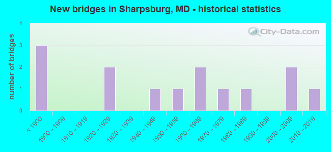
- New bridges - historical statistics
- 3Before 1900
- 21920-1929
- 11940-1949
- 11950-1959
- 21960-1969
- 11970-1979
- 11980-1989
- 22000-2009
- 12010-2019

- Reconstructed bridges - Historical Statistics
- 11960-1969
- 11970-1979
- 11980-1989
- 21990-1999
- 02000-2009
- 42010-2019


- Bridge Condition - Deck
- 37.5%Good
- 50.0%Satisfactory
- 12.5%Fair

- Bridge Condition - Superstructure
- 8.3%Very good
- 50.0%Good
- 25.0%Satisfactory
- 8.3%Fair
- 8.3%Poor

- Bridge Condition - Substructure
- 8.3%Very good
- 41.7%Good
- 33.3%Satisfactory
- 16.7%Fair

- Bridge Condition - Channel
- 23.1%Very good
- 30.8%Good
- 30.8%Satisfactory
- 15.4%Fair
Find on map >> Show street view
Structure Number: 10000021000301, Location: 1.2 MILES EAST OF MD 65 (Lat: 39.465083, Lng: -77.725822), Route carried "on" structure: State highway 34, Year Built: 1958, Year Reconstructed: 1980, Status: Open, Structure Length: 7.47m (24.51ft), Average Daily Traffic: 4,951 (year 2009), Truck Traffic: 8%, Average Future Daily Traffic: 5,570 (year 2026), Design Load: HS 20, Features Intersected: ANTIETAM CREEK
Minimum Vertical Clearance: 30+ m (98+ ft), Kilometerpoint: 7.675, Lanes on structure: 2, Base Highway Network: Yes, Owner: State Highway Agency, Approaching Roadway Width: 13.4m (44.0ft), Material/Design: Steel continuous, Design/Construction: Stringer/Multi-beam, Number Of Spans In Main Unit: 4, Length of Maximum Span: 18.3m (60.0ft), Curb-To-Curb Width: 11.0m (36.1ft), Out-to-Out Width: 11.9m (39.0ft)
Condition: Deck: Satisfactory, Superstructure: Good, Substructure: Satisfactory, Channel: Satisfactory, Operating Rating: 38.5 metric tons, Method Used To Determine Operating Rating: Load Factor (LF), Inventory Rating: 23.1 metric tons, Method Used To Determine Inventory Rating: Load Factor (LF), Structural Evaluation: Equal to present minimum criteria, Deck Geometry: Somewhat better than minimum adequacy, Waterway Adequacy: Superior to present desirable criteria, Approach Roadway Alignment: Equal to present desirable criteria, Designated Inspection Frequency: Every 24 months, Inspection Date: September 2020, Deck Structure Type: Concrete Cast-file-Place, Wearing Surface/Protective System: Wearing Surface: Monolithic Concrete
Find on map >> Show street view
Structure Number: 200000W-565201, Location: 0.1 MI NW OF MD RTE 34 (Lat: 39.482511, Lng: -77.706714), Route carried "on" structure: County highway 565, Year Built: 1858, Year Reconstructed: 2003, Status: Open, Structure Length: 2.07m (6.79ft), Average Daily Traffic: 1,173 (year 2015), Truck Traffic: 5%, Average Future Daily Traffic: 1,617 (year 2037), Features Intersected: LITTLE ANTIETAM CREEK, Facility Carried by Structure: KEEDYSVILLE ROAD
Minimum Vertical Clearance: 30+ m (98+ ft), Kilometerpoint: 5.213, Lanes on structure: 1, Owner: County Highway Agency, Approaching Roadway Width: 4.9m (16.1ft), Material/Design: Masonry, Design/Construction: Arch - Deck, Number Of Spans In Main Unit: 2, Length of Maximum Span: 9.4m (30.8ft), Curb-To-Curb Width: 3.7m (12.1ft), Out-to-Out Width: 4.8m (15.7ft)
Condition: Deck: Satisfactory, Superstructure: Satisfactory, Substructure: Satisfactory, Channel: Fair, Structural Evaluation: Equal to present minimum criteria, Deck Geometry: High priority of replacement, Waterway Adequacy: Equal to present desirable criteria, Approach Roadway Alignment: High priority of corrective action, Length Of Structure Improvement: 2.07m (6.79ft), Designated Inspection Frequency: Every 24 months, Inspection Date: November 2021, Bridge Improvement Cost: $14,000, Roadway Improvement Cost: $11,000, Total Project Cost: $25,000, Wearing Surface/Protective System: Wearing Surface: Bituminous
Find on map >> Show street view
Structure Number: 200000W-566101, Location: 0.68 MI S OF BAKERSVILLE (Lat: 39.514219, Lng: -77.777536), Route carried "on" structure: County highway 575, Year Built: 1920, Year Reconstructed: 2015, Status: Open, Structure Length: 0.82m (2.69ft), Average Daily Traffic: 347 (year 2017), Truck Traffic: 5%, Average Future Daily Traffic: 478 (year 2037), Features Intersected: MARSH RUN, Facility Carried by Structure: SPRECHER ROAD
Minimum Vertical Clearance: 30+ m (98+ ft), Kilometerpoint: 1.142, Lanes on structure: 1, Owner: County Highway Agency, Approaching Roadway Width: 4.6m (15.1ft), Material/Design: Prestressed concrete, Design/Construction: Slab, Number Of Spans In Main Unit: 1, Length of Maximum Span: 7.9m (25.9ft), Curb-To-Curb Width: 4.6m (15.1ft), Out-to-Out Width: 5.2m (17.1ft)
Condition: Deck: Good, Superstructure: Good, Substructure: Good, Channel: Good, Operating Rating: 67.4 metric tons, Method Used To Determine Operating Rating: Load and Resistance Factor Rating (LRFR) rating reported by rating factor(RF) method using HL-93 loadings, Inventory Rating: 51.8 metric tons, Method Used To Determine Inventory Rating: Load and Resistance Factor Rating (LRFR) rating reported by rating factor(RF) method using HL-93 loadings, Structural Evaluation: Better than present minimum criteria, Deck Geometry: High priority of replacement, Waterway Adequacy: Equal to present minimum criteria, Approach Roadway Alignment: High priority of corrective action, Designated Inspection Frequency: Every 24 months, Inspection Date: November 2021, Deck Structure Type: Concrete Cast-file-Place, Wearing Surface/Protective System: Wearing Surface: Integral Concrete
Find on map >> Show street view
Structure Number: 200000W-566201, Location: 0.07 MI S OF BAKERSVILLE (Lat: 39.520497, Lng: -77.771200), Route carried "on" structure: County highway 575, Year Built: 1986, Year Reconstructed: 2015, Status: Open, Structure Length: 0.82m (2.69ft), Average Daily Traffic: 345 (year 2017), Truck Traffic: 5%, Average Future Daily Traffic: 475 (year 2037), Features Intersected: MARSH RUN, Facility Carried by Structure: SPRECHER ROAD
Minimum Vertical Clearance: 30+ m (98+ ft), Kilometerpoint: 0.113, Lanes on structure: 1, Owner: County Highway Agency, Approaching Roadway Width: 4.6m (15.1ft), Material/Design: Prestressed concrete, Design/Construction: Slab, Number Of Spans In Main Unit: 1, Length of Maximum Span: 7.9m (25.9ft), Curb-To-Curb Width: 4.6m (15.1ft), Out-to-Out Width: 5.2m (17.1ft)
Condition: Deck: Good, Superstructure: Good, Substructure: Good, Channel: Very good, Operating Rating: 67.4 metric tons, Method Used To Determine Operating Rating: Load and Resistance Factor Rating (LRFR) rating reported by rating factor(RF) method using HL-93 loadings, Inventory Rating: 51.8 metric tons, Method Used To Determine Inventory Rating: Load and Resistance Factor Rating (LRFR) rating reported by rating factor(RF) method using HL-93 loadings, Structural Evaluation: Better than present minimum criteria, Deck Geometry: High priority of replacement, Waterway Adequacy: Better than present minimum criteria, Approach Roadway Alignment: High priority of corrective action, Designated Inspection Frequency: Every 24 months, Inspection Date: November 2021, Deck Structure Type: Concrete Cast-file-Place, Wearing Surface/Protective System: Wearing Surface: Integral Concrete
Find on map >> Show street view
Structure Number: 200000W-573101, Location: ANTIETAM MD (Lat: 39.417225, Lng: -77.742108), Route carried "on" structure: County highway 580, Year Built: 1832, Year Reconstructed: 2010, Status: Open, Structure Length: 4.60m (15.09ft), Average Daily Traffic: 665 (year 2019), Truck Traffic: 5%, Average Future Daily Traffic: 1,090 (year 2039), Features Intersected: ANTIETAM CREEK, Facility Carried by Structure: HARPERS FERRY ROAD
Minimum Vertical Clearance: 30+ m (98+ ft), Kilometerpoint: 12.132, Lanes on structure: 1, Owner: County Highway Agency, Approaching Roadway Width: 7.9m (25.9ft), Material/Design: Masonry, Design/Construction: Arch - Deck, Number Of Spans In Main Unit: 4, Length of Maximum Span: 11.0m (36.1ft), Curb-To-Curb Width: 4.5m (14.8ft), Out-to-Out Width: 5.8m (19.0ft)
Condition: Superstructure: Good, Substructure: Good, Channel: Fair, Inventory Rating: 77.1 metric tons, Method Used To Determine Inventory Rating: Load Factor (LF), Structural Evaluation: Better than present minimum criteria, Deck Geometry: High priority of replacement, Waterway Adequacy: Equal to present minimum criteria, Approach Roadway Alignment: High priority of corrective action, Length Of Structure Improvement: 4.60m (15.09ft), Designated Inspection Frequency: Every 24 months, Underwater Inspection Frequency: Every 48 months, Inspection Date: November 2021, Underwater Inspection Date: November 2019, Bridge Improvement Cost: $9,000, Roadway Improvement Cost: $1,000, Total Project Cost: $10,000 ( Estimate for 2017), Wearing Surface/Protective System: Wearing Surface: Bituminous
Find on map >> Show street view
Structure Number: 200000W-580101, Location: 1.0 MI W OF US RTE 340 (Lat: 39.324053, Lng: -77.721847), Route carried "on" structure: County highway 626, Year Built: 1925, Year Reconstructed: 1990, Status: Open, Structure Length: 1.56m (5.12ft), Average Daily Traffic: 1,727 (year 2018), Truck Traffic: 5%, Average Future Daily Traffic: 2,975 (year 2038), Features Intersected: CSXT RAILROAD, Facility Carried by Structure: SANDY HOOK ROAD
Minimum Vertical Clearance: 30+ m (98+ ft), Kilometerpoint: 4.023, Lanes on structure: 2, Owner: County Highway Agency, Approaching Roadway Width: 5.2m (17.1ft), Skew: 2 degrees, Material/Design: Steel, Design/Construction: Stringer/Multi-beam, Number Of Spans In Main Unit: 1, Length of Maximum Span: 15.5m (50.9ft), Curb-To-Curb Width: 6.9m (22.6ft), Out-to-Out Width: 7.2m (23.6ft)
Condition: Deck: Good, Superstructure: Satisfactory, Substructure: Fair, Inventory Rating: 65.3 metric tons, Method Used To Determine Inventory Rating: Load Factor (LF), Structural Evaluation: Somewhat better than minimum adequacy, Deck Geometry: High priority of corrective action, Underclear: High priority of corrective action, Approach Roadway Alignment: High priority of corrective action, Designated Inspection Frequency: Every 24 months, Inspection Date: April 2020, Deck Structure Type: Concrete Cast-file-Place, Wearing Surface/Protective System: Wearing Surface: Monolithic Concrete
Find on map >> Show street view
Structure Number: 200000W-585103, Location: 0.83 MI SW OF MD RTE 34 (Lat: 39.433694, Lng: -77.706361), Route carried "on" structure: County highway 585, Year Built: 1978, Status: Open, Structure Length: 0.77m (2.53ft), Average Daily Traffic: 310 (year 2017), Truck Traffic: 5%, Average Future Daily Traffic: 534 (year 2037), Design Load: H 20, Features Intersected: SHARMANS BRANCH, Facility Carried by Structure: BURNSIDE BRIDGE RD
Minimum Vertical Clearance: 30+ m (98+ ft), Kilometerpoint: 5.213, Lanes on structure: 2, Owner: County Highway Agency, Approaching Roadway Width: 7.3m (24.0ft), Skew: 2 degrees, Material/Design: Steel, Design/Construction: Culvert, Length of Maximum Span: 7.0m (23.0ft)
Condition: Channel: Satisfactory, Culverts: Satisfactory, Operating Rating: 69.4 metric tons, Method Used To Determine Operating Rating: Load Factor (LF), Inventory Rating: 58.0 metric tons, Method Used To Determine Inventory Rating: Load Factor (LF), Structural Evaluation: Equal to present minimum criteria, Waterway Adequacy: Equal to present desirable criteria, Approach Roadway Alignment: Equal to present minimum criteria, Designated Inspection Frequency: Every 24 months, Inspection Date: November 2021
Find on map >> Show street view
Structure Number: 200000W-585201, Location: 0.83 MI SW OF MD RTE 34 (Lat: 39.454008, Lng: -77.733103), Route carried "on" structure: County highway 585, Year Built: 1965, Status: Open, Structure Length: 5.35m (17.55ft), Average Daily Traffic: 447 (year 2019), Truck Traffic: 5%, Average Future Daily Traffic: 667 (year 2039), Design Load: HS 20, Features Intersected: ANTIETAM CREEK, Facility Carried by Structure: BURNSIDE BRIDGE RO
Minimum Vertical Clearance: 30+ m (98+ ft), Kilometerpoint: 1.432, Lanes on structure: 2, Owner: County Highway Agency, Approaching Roadway Width: 9.1m (29.9ft), Skew: 2 degrees, Material/Design: Prestressed concrete continuous, Design/Construction: Stringer/Multi-beam, Number Of Spans In Main Unit: 3, Length of Maximum Span: 17.7m (58.1ft), Curb or Sidewalk Widths: Left: 0.3m (1.0ft), Right: 0.9m (3.0ft), Curb-To-Curb Width: 7.4m (24.3ft), Out-to-Out Width: 9.2m (30.2ft)
Condition: Deck: Satisfactory, Superstructure: Satisfactory, Substructure: Satisfactory, Channel: Satisfactory, Operating Rating: 45.4 metric tons, Method Used To Determine Operating Rating: Load Factor (LF), Inventory Rating: 27.2 metric tons, Method Used To Determine Inventory Rating: Load Factor (LF), Structural Evaluation: Equal to present minimum criteria, Deck Geometry: Meets minimum limits, Waterway Adequacy: Equal to present desirable criteria, Approach Roadway Alignment: Equal to present desirable criteria, Designated Inspection Frequency: Every 12 months, Underwater Inspection Frequency: Every 48 months, Inspection Date: December 2021, Underwater Inspection Date: November 2019, Deck Structure Type: Concrete Cast-file-Place, Wearing Surface/Protective System: Wearing Surface: Bituminous
Find on map >> Show street view
Structure Number: 200000W-619101, Location: 0.3 MI W OF MD RTE 67 (Lat: 39.370536, Lng: -77.675883), Route carried "on" structure: County highway 619, Year Built: 1940, Year Reconstructed: 1960, Status: Posted for load, Structure Length: 0.73m (2.40ft), Average Daily Traffic: 570 (year 2016), Truck Traffic: 5%, Average Future Daily Traffic: 970 (year 2036), Design Load: HS 20, Features Intersected: ISRAEL CREEK, Facility Carried by Structure: YARROWSBURG ROAD
Minimum Vertical Clearance: 30+ m (98+ ft), Kilometerpoint: 0.000, Lanes on structure: 2, Owner: County Highway Agency, Approaching Roadway Width: 6.7m (22.0ft), Material/Design: Steel, Design/Construction: Stringer/Multi-beam, Number Of Spans In Main Unit: 1, Length of Maximum Span: 6.7m (22.0ft), Curb-To-Curb Width: 8.2m (26.9ft), Out-to-Out Width: 9.1m (29.9ft)
Condition: Deck: Fair, Superstructure: Poor, Substructure: Fair, Channel: Satisfactory, Operating Rating: 23.1 metric tons, Method Used To Determine Operating Rating: Load Factor (LF), Inventory Rating: 13.6 metric tons, Method Used To Determine Inventory Rating: Load Factor (LF), Structural Evaluation: Meets minimum limits, Deck Geometry: Somewhat better than minimum adequacy, Waterway Adequacy: Better than present minimum criteria, Approach Roadway Alignment: Equal to present minimum criteria, Bridge Posting: Required (Relationship of Operating Rating to Maximum Legal Load: > 39.9% below), Length Of Structure Improvement: 7.32m (24.02ft), Designated Inspection Frequency: Every 12 months, Inspection Date: November 2021, Bridge Improvement Cost: $280,000, Roadway Improvement Cost: $28,000, Total Project Cost: $308,000 ( Estimate for 2014), Deck Structure Type: Concrete Cast-file-Place, Wearing Surface/Protective System: Wearing Surface: Bituminous
Find on map >> Show street view
Structure Number: 200000W-623101, Location: 0.25 MI W OF MD RTE 67 (Lat: 39.352433, Lng: -77.685258), Route carried "on" structure: County highway 623, Year Built: 2019, Status: Open, Structure Length: 0.83m (2.72ft), Average Daily Traffic: 590 (year 2018), Truck Traffic: 1%, Average Future Daily Traffic: 813 (year 2040), Design Load: HS 20, Features Intersected: ISRAEL CREEK, Facility Carried by Structure: GARRETTS MILL ROAD
Minimum Vertical Clearance: 30+ m (98+ ft), Kilometerpoint: 0.000, Lanes on structure: 2, Owner: County Highway Agency, Approaching Roadway Width: 7.0m (23.0ft), Material/Design: Concrete, Design/Construction: Arch - Deck, Number Of Spans In Main Unit: 1, Length of Maximum Span: 7.9m (25.9ft), Curb-To-Curb Width: 7.4m (24.3ft), Out-to-Out Width: 8.6m (28.2ft)
Condition: Superstructure: Very good, Substructure: Very good, Channel: Good, Operating Rating: 50.5 metric tons, Method Used To Determine Operating Rating: Load and Resistance Factor Rating (LRFR) rating reported by rating factor(RF) method using HL-93 loadings, Inventory Rating: 36.3 metric tons, Method Used To Determine Inventory Rating: Load and Resistance Factor Rating (LRFR) rating reported by rating factor(RF) method using HL-93 loadings, Structural Evaluation: Equal to present desirable criteria, Deck Geometry: Meets minimum limits, Waterway Adequacy: Equal to present desirable criteria, Approach Roadway Alignment: Equal to present minimum criteria, Designated Inspection Frequency: Every 24 months, Inspection Date: November 2021
Find on map >> Show street view
Structure Number: 200000W-637101, Location: 0.1 MI E OF MD RTE 34 (Lat: 39.817639, Lng: -78.170478), Route carried "on" structure: County highway 637, Year Built: 1832, Year Reconstructed: 2015, Status: Open, Structure Length: 1.66m (5.45ft), Average Daily Traffic: 362 (year 2019), Truck Traffic: 5%, Average Future Daily Traffic: 555 (year 2039), Features Intersected: LITTLE ANTIETAM CREEK, Facility Carried by Structure: COFFMAN FARMS RD
Minimum Vertical Clearance: 30+ m (98+ ft), Kilometerpoint: 0.064, Lanes on structure: 1, Owner: County Highway Agency, Approaching Roadway Width: 8.5m (27.9ft), Material/Design: Masonry, Design/Construction: Arch - Deck, Number Of Spans In Main Unit: 2, Length of Maximum Span: 6.7m (22.0ft), Curb-To-Curb Width: 5.1m (16.7ft), Out-to-Out Width: 6.0m (19.7ft)
Condition: Superstructure: Good, Substructure: Good, Channel: Good, Structural Evaluation: Better than present minimum criteria, Deck Geometry: High priority of replacement, Waterway Adequacy: Superior to present desirable criteria, Approach Roadway Alignment: Equal to present minimum criteria, Length Of Structure Improvement: 2.01m (6.59ft), Designated Inspection Frequency: Every 24 months, Underwater Inspection Frequency: Every 48 months, Inspection Date: October 2021, Underwater Inspection Date: October 2019, Bridge Improvement Cost: $654,000, Roadway Improvement Cost: $65,000, Total Project Cost: $719,000, Wearing Surface/Protective System: Wearing Surface: Bituminous
Find on map >> Show street view
Structure Number: 200000W-660102, Location: 0.01 MI NORTH OF RT 63 (Lat: 39.538467, Lng: -77.771158), Route carried "on" structure: County highway , Year Built: 2005, Status: Open, Structure Length: 1.16m (3.81ft), Average Daily Traffic: 84 (year 2015), Truck Traffic: 1%, Average Future Daily Traffic: 115 (year 2037), Design Load: HS 25 or greater, Features Intersected: TRIBUTARY OF MARSH RUN, Facility Carried by Structure: PROPHET ACRES ROAD
Minimum Vertical Clearance: 30+ m (98+ ft), Kilometerpoint: 0.000, Lanes on structure: 2, Owner: County Highway Agency, Approaching Roadway Width: 5.5m (18.0ft), Material/Design: Concrete, Design/Construction: Culvert, Length of Maximum Span: 2.4m (7.9ft), Curb-To-Curb Width: 9.1m (29.9ft), Out-to-Out Width: 9.4m (30.8ft)
Condition: Channel: Very good, Culverts: Satisfactory, Operating Rating: 90.2 metric tons, Method Used To Determine Operating Rating: Load Factor (LF), Inventory Rating: 54.0 metric tons, Method Used To Determine Inventory Rating: Load Factor (LF), Structural Evaluation: Equal to present minimum criteria, Deck Geometry: Better than present minimum criteria, Waterway Adequacy: Better than present minimum criteria, Approach Roadway Alignment: Equal to present desirable criteria, Designated Inspection Frequency: Every 24 months, Inspection Date: November 2021
Find on map >> Show street view
Structure Number: 200000W-800102, Location: 0.6 MI S OF BURNSIDE DR (Lat: 39.428811, Lng: -77.723642), Route carried "on" structure: County highway 587, Year Built: 2009, Status: Open, Structure Length: 1.56m (5.12ft), Average Daily Traffic: 910 (year 2018), Truck Traffic: 5%, Average Future Daily Traffic: 1,254 (year 2038), Design Load: HS 25 or greater, Features Intersected: SHARMANS BRANCH, Facility Carried by Structure: MILLS ROAD
Minimum Vertical Clearance: 30+ m (98+ ft), Kilometerpoint: 0.000, Lanes on structure: 2, Owner: County Highway Agency, Approaching Roadway Width: 9.8m (32.2ft), Skew: 4 degrees, Material/Design: Concrete, Design/Construction: Arch - Deck, Length of Maximum Span: 4.9m (16.1ft), Curb-To-Curb Width: 9.8m (32.2ft), Out-to-Out Width: 9.8m (32.2ft)
Condition: Superstructure: Good, Substructure: Good, Channel: Good, Operating Rating: 80.3 metric tons, Method Used To Determine Operating Rating: Load Factor (LF), Inventory Rating: 48.1 metric tons, Method Used To Determine Inventory Rating: Load Factor (LF), Structural Evaluation: Better than present minimum criteria, Deck Geometry: Equal to present minimum criteria, Waterway Adequacy: Equal to present desirable criteria, Approach Roadway Alignment: Equal to present desirable criteria, Designated Inspection Frequency: Every 24 months, Inspection Date: Febuary 2020
Find on map >> Show street view
Structure Number: 3100006P, Location: 2.0 miles west of Sharpsb (Lat: 39.465278, Lng: -77.777333), Route carried "on" structure: Spur Federal lands road 214, Year Built: 1969, Year Reconstructed: 1977, Status: Posted for load, Structure Length: 1.28m (4.20ft), Average Daily Traffic: 212 (year 2007), Truck Traffic: 2%, Average Future Daily Traffic: 233 (year 2027), Features Intersected: C&O CANAL, Facility Carried by Structure: SNYDERS LANDING AC
Minimum Vertical Clearance: 30+ m (98+ ft), Kilometerpoint: 123.759, Lanes on structure: 1, Owner: National Park Service, Approaching Roadway Width: 3.4m (11.2ft), Material/Design: Steel, Design/Construction: Stringer/Multi-beam, Number Of Spans In Main Unit: 1, Length of Maximum Span: 12.5m (41.0ft), Curb-To-Curb Width: 3.0m (9.8ft), Out-to-Out Width: 3.7m (12.1ft)
Condition: Deck: Satisfactory, Superstructure: Fair, Substructure: Satisfactory, Channel: Very good, Operating Rating: 35.3 metric tons, Method Used To Determine Operating Rating: Load Factor (LF), Inventory Rating: 21.1 metric tons, Method Used To Determine Inventory Rating: Load Factor (LF), Structural Evaluation: Somewhat better than minimum adequacy, Deck Geometry: High priority of replacement, Waterway Adequacy: Equal to present desirable criteria, Approach Roadway Alignment: Equal to present desirable criteria, Designated Inspection Frequency: Every 24 months, Inspection Date: October 2021, Bridge Improvement Cost: $90,000, Roadway Improvement Cost: $9,000, Total Project Cost: $135,000 ( Estimate for 2017), Deck Structure Type: Wood or Timber