Bridge Statistics for Sharon, Vermont (VT)
Condition, Traffic, Stress, Structural Evaluation, Project Costs
- National Bridge Inventory (NBI) Statistics
- 21Number of bridges
- 397ft / 121mTotal length
- $39,807,000Total costs
- 182,410Total average daily traffic
- 22,633Total average daily truck traffic
- National Bridge Inventory (NBI) Registered Bridges for Sharon
- No street view available for this location
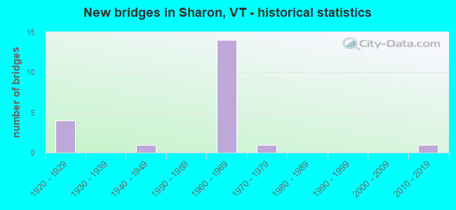
- New bridges - historical statistics
- 41920-1929
- 11940-1949
- 141960-1969
- 11970-1979
- 12010-2019

- Reconstructed bridges - Historical Statistics
- 11980-1989
- 01990-1999
- 12000-2009


- Bridge Condition - Deck
- 20.0%Very good
- 40.0%Good
- 33.3%Satisfactory
- 6.7%Fair

- Bridge Condition - Superstructure
- 20.0%Very good
- 20.0%Good
- 46.7%Satisfactory
- 13.3%Fair

- Bridge Condition - Substructure
- 20.0%Very good
- 6.7%Good
- 53.3%Satisfactory
- 20.0%Fair

- Bridge Condition - Channel
- 77.8%Very good
- 11.1%Good
- 11.1%Satisfactory
Find on map >> Show street view
Structure Number: 101417001314171, Location: 0.2 MI JCT TH 4 + TH 35 (Lat: 43.778944, Lng: -72.486597), Route carried "on" structure: Other road C2004, Year Built: 1929, Status: Open, Structure Length: 1.04m (3.41ft), Average Daily Traffic: 125 (year 2019), Truck Traffic: 3%, Average Future Daily Traffic: 132 (year 2029), Features Intersected: BROAD BROOK
Minimum Vertical Clearance: 30+ m (98+ ft), Kilometerpoint: 0.000, Lanes on structure: 2, Owner: Town or Township Highway Agency, Approaching Roadway Width: 5.5m (18.0ft), Skew: 1 degrees, Material/Design: Concrete, Design/Construction: Tee Beam, Number Of Spans In Main Unit: 1, Length of Maximum Span: 9.8m (32.2ft), Curb or Sidewalk Widths: Left: 0.2m (0.7ft), Right: 0.2m (0.7ft), Curb-To-Curb Width: 6.4m (21.0ft), Out-to-Out Width: 7.1m (23.3ft)
Condition: Deck: Good, Superstructure: Very good, Substructure: Good, Channel: Satisfactory, Operating Rating: 50.8 metric tons, Method Used To Determine Operating Rating: Allowable Stress (AS), Inventory Rating: 30.8 metric tons, Method Used To Determine Inventory Rating: Allowable Stress (AS), Structural Evaluation: Better than present minimum criteria, Deck Geometry: Meets minimum limits, Waterway Adequacy: Equal to present minimum criteria, Approach Roadway Alignment: Equal to present desirable criteria, Designated Inspection Frequency: Every 24 months, Inspection Date: August 2020, Deck Structure Type: Concrete Cast-file-Place
Find on map >> Show street view
Structure Number: 101417001414171, Location: 0.5 MI JCT TH 4 + TH 34 (Lat: 43.778586, Lng: -72.501142), Route carried "on" structure: Other road C2004, Year Built: 2014, Status: Open, Structure Length: 1.92m (6.30ft), Average Daily Traffic: 125 (year 2019), Truck Traffic: 3%, Average Future Daily Traffic: 132 (year 2029), Design Load: HL 93, Features Intersected: BROAD BROOK
Minimum Vertical Clearance: 30+ m (98+ ft), Kilometerpoint: 0.000, Lanes on structure: 2, Owner: Town or Township Highway Agency, Approaching Roadway Width: 7.3m (24.0ft), Skew: 4 degrees, Material/Design: Prestressed concrete, Design/Construction: Box Beam or Girders - Multiple, Number Of Spans In Main Unit: 1, Length of Maximum Span: 18.3m (60.0ft), Curb-To-Curb Width: 6.9m (22.6ft), Out-to-Out Width: 7.3m (24.0ft)
Condition: Deck: Very good, Superstructure: Very good, Substructure: Very good, Channel: Very good, Operating Rating: 47.2 metric tons, Method Used To Determine Operating Rating: Load and Resistance Factor (LRFR), Inventory Rating: 36.3 metric tons, Method Used To Determine Inventory Rating: Load and Resistance Factor (LRFR), Structural Evaluation: Equal to present desirable criteria, Deck Geometry: Meets minimum limits, Waterway Adequacy: Equal to present minimum criteria, Approach Roadway Alignment: Equal to present minimum criteria, Designated Inspection Frequency: Every 24 months, Inspection Date: August 2020, Deck Structure Type: Concrete Cast-file-Place, Wearing Surface/Protective System: Deck Protection: Epoxy Coated Reinforcing
Find on map >> Show street view
Structure Number: 101417002714171, Location: 0.1 MI JCT TH 44 + TH 11 (Lat: 43.754772, Lng: -72.394517), Route carried "on" structure: Other road C3044, Year Built: 1974, Status: Open, Structure Length: 0.94m (3.08ft), Average Daily Traffic: 10 (year 2019), Truck Traffic: 2%, Average Future Daily Traffic: 11 (year 2029), Design Load: H 20, Features Intersected: MITCHELL BROOK
Minimum Vertical Clearance: 30+ m (98+ ft), Kilometerpoint: 0.000, Lanes on structure: 1, Owner: Town or Township Highway Agency, Approaching Roadway Width: 3.7m (12.1ft), Material/Design: Steel, Design/Construction: Stringer/Multi-beam, Number Of Spans In Main Unit: 1, Length of Maximum Span: 8.8m (28.9ft), Curb or Sidewalk Widths: Left: 0.3m (1.0ft), Right: 0.3m (1.0ft), Curb-To-Curb Width: 3.6m (11.8ft), Out-to-Out Width: 4.3m (14.1ft)
Condition: Deck: Very good, Superstructure: Good, Substructure: Very good, Channel: Good, Operating Rating: 89.8 metric tons, Method Used To Determine Operating Rating: Allowable Stress (AS), Inventory Rating: 89.8 metric tons, Method Used To Determine Inventory Rating: Allowable Stress (AS), Structural Evaluation: Better than present minimum criteria, Deck Geometry: High priority of corrective action, Waterway Adequacy: Better than present minimum criteria, Approach Roadway Alignment: Equal to present desirable criteria, Length Of Structure Improvement: 0.94m (3.08ft), Designated Inspection Frequency: Every 24 months, Inspection Date: August 2020, Bridge Improvement Cost: $152,000, Roadway Improvement Cost: $50,000, Total Project Cost: $202,000 ( Estimate for 2020), Deck Structure Type: Concrete Cast-file-Place, Wearing Surface/Protective System: Wearing Surface: Gravel
Find on map >> Show street view
Structure Number: 200089001414172, Location: 1.1 MI S EXIT 2 (Lat: 43.772931, Lng: -72.445014), Route carried "on" structure: Interstate 89, Year Built: 1968, Status: Open, Structure Length: 0.64m (2.10ft), Average Daily Traffic: 18,800 (year 2018), Truck Traffic: 13%, Average Future Daily Traffic: 19,740 (year 2028), Design Load: HS 20, Features Intersected: I 89 OVER TH NO 11
Minimum Vertical Clearance: 30+ m (98+ ft), Kilometerpoint: 19.855, Lanes on structure: 4, Lanes under structure: 2, Base Highway Network: Yes, Owner: State Highway Agency, Approaching Roadway Width: 23.2m (76.1ft), Skew: 14 degrees, Material/Design: Concrete, Design/Construction: Frame, Number Of Spans In Main Unit: 1, Length of Maximum Span: 6.4m (21.0ft), Curb-To-Curb Width: 11.6m (38.1ft), Out-to-Out Width: 11.6m (38.1ft)
Condition: Deck: Satisfactory, Superstructure: Satisfactory, Substructure: Satisfactory, Operating Rating: 54.4 metric tons, Method Used To Determine Operating Rating: Field evaluation and documented engineering judgment, Inventory Rating: 32.7 metric tons, Method Used To Determine Inventory Rating: Field evaluation and documented engineering judgment, Structural Evaluation: Equal to present minimum criteria, Deck Geometry: High priority of replacement, Underclear: High priority of corrective action, Approach Roadway Alignment: Equal to present desirable criteria, Length Of Structure Improvement: 0.64m (2.10ft), Designated Inspection Frequency: Every 24 months, Inspection Date: May 2020, Bridge Improvement Cost: $279,000, Roadway Improvement Cost: $50,000, Total Project Cost: $329,000 ( Estimate for 2020)
Find on map >> Show street view
Structure Number: 200089001914172, Location: 1.6 MI N EXIT 2 (Lat: 43.782856, Lng: -72.483081), Route carried "on" structure: Interstate 89, Year Built: 1968, Status: Open, Structure Length: 0.64m (2.10ft), Average Daily Traffic: 15,800 (year 2018), Truck Traffic: 13%, Average Future Daily Traffic: 16,590 (year 2028), Design Load: HS 20, Features Intersected: I 89 OVER TH NO 4
Minimum Vertical Clearance: 30+ m (98+ ft), Kilometerpoint: 24.167, Lanes on structure: 4, Lanes under structure: 2, Base Highway Network: Yes, Owner: State Highway Agency, Approaching Roadway Width: 23.2m (76.1ft), Skew: 12 degrees, Material/Design: Concrete, Design/Construction: Frame, Number Of Spans In Main Unit: 1, Length of Maximum Span: 6.4m (21.0ft), Curb-To-Curb Width: 11.6m (38.1ft), Out-to-Out Width: 11.6m (38.1ft)
Condition: Deck: Satisfactory, Superstructure: Satisfactory, Substructure: Satisfactory, Operating Rating: 54.4 metric tons, Method Used To Determine Operating Rating: Field evaluation and documented engineering judgment, Inventory Rating: 32.7 metric tons, Method Used To Determine Inventory Rating: Field evaluation and documented engineering judgment, Structural Evaluation: Equal to present minimum criteria, Deck Geometry: High priority of replacement, Underclear: High priority of corrective action, Approach Roadway Alignment: Equal to present desirable criteria, Length Of Structure Improvement: 0.64m (2.10ft), Designated Inspection Frequency: Every 24 months, Inspection Date: May 2020, Bridge Improvement Cost: $279,000, Roadway Improvement Cost: $50,000, Total Project Cost: $329,000 ( Estimate for 2020)
Find on map >> Show street view
Structure Number: 200089015N14172, Location: I 89 EXIT 2 (Lat: 43.786367, Lng: -72.452261), Route carried "on" structure: Interstate 89, Year Built: 1968, Status: Open, Structure Length: 5.24m (17.19ft), Average Daily Traffic: 18,800 (year 2018), Truck Traffic: 13%, Average Future Daily Traffic: 19,740 (year 2028), Design Load: HS 20, Features Intersected: I 89 OVER VT 132
Minimum Vertical Clearance: 30+ m (98+ ft), Kilometerpoint: 21.593, Lanes on structure: 2, Lanes under structure: 2, Base Highway Network: Yes, Owner: State Highway Agency, Approaching Roadway Width: 11.6m (38.1ft), Skew: 13 degrees, Material/Design: Steel, Design/Construction: Stringer/Multi-beam, Number Of Spans In Main Unit: 3, Length of Maximum Span: 25.0m (82.0ft), Curb or Sidewalk Widths: Left: 0.6m (2.0ft), Right: 0.8m (2.6ft), Curb-To-Curb Width: 11.6m (38.1ft), Out-to-Out Width: 12.9m (42.3ft)
Condition: Deck: Good, Superstructure: Satisfactory, Substructure: Fair, Operating Rating: 61.7 metric tons, Method Used To Determine Operating Rating: Load Factor (LF), Inventory Rating: 36.3 metric tons, Method Used To Determine Inventory Rating: Load Factor (LF), Structural Evaluation: Somewhat better than minimum adequacy, Deck Geometry: Equal to present minimum criteria, Underclear: Superior to present desirable criteria, Approach Roadway Alignment: Equal to present desirable criteria, Designated Inspection Frequency: Every 24 months, Inspection Date: May 2020, Deck Structure Type: Concrete Cast-file-Place, Wearing Surface/Protective System: Wearing Surface: Bituminous, Membrane: Preformed Fabric
Find on map >> Show street view
Structure Number: 200089015S14172, Location: I 89 EXIT 2 (Lat: 43.786181, Lng: -72.452572), Route carried "on" structure: Interstate 89, Year Built: 1968, Status: Open, Structure Length: 5.24m (17.19ft), Average Daily Traffic: 18,800 (year 2018), Truck Traffic: 13%, Average Future Daily Traffic: 19,740 (year 2028), Design Load: HS 20, Features Intersected: I 89 OVER VT 132
Minimum Vertical Clearance: 30+ m (98+ ft), Kilometerpoint: 21.593, Lanes on structure: 2, Lanes under structure: 2, Base Highway Network: Yes, Owner: State Highway Agency, Approaching Roadway Width: 11.6m (38.1ft), Skew: 14 degrees, Material/Design: Steel, Design/Construction: Stringer/Multi-beam, Number Of Spans In Main Unit: 3, Length of Maximum Span: 25.0m (82.0ft), Curb or Sidewalk Widths: Left: 0.6m (2.0ft), Right: 0.8m (2.6ft), Curb-To-Curb Width: 11.6m (38.1ft), Out-to-Out Width: 13.0m (42.7ft)
Condition: Deck: Good, Superstructure: Satisfactory, Substructure: Fair, Operating Rating: 61.7 metric tons, Method Used To Determine Operating Rating: Load Factor (LF), Inventory Rating: 36.3 metric tons, Method Used To Determine Inventory Rating: Load Factor (LF), Structural Evaluation: Somewhat better than minimum adequacy, Deck Geometry: Equal to present minimum criteria, Underclear: Somewhat better than minimum adequacy, Approach Roadway Alignment: Equal to present desirable criteria, Designated Inspection Frequency: Every 24 months, Inspection Date: May 2020, Deck Structure Type: Concrete Cast-file-Place, Wearing Surface/Protective System: Wearing Surface: Bituminous, Membrane: Preformed Fabric
Find on map >> Show street view
Structure Number: 200089016N14172, Location: 0.5 MI N EXIT 2 (Lat: 43.784733, Lng: -72.461814), Route carried "on" structure: Interstate 89, Year Built: 1968, Status: Open, Structure Length: 10.85m (35.60ft), Average Daily Traffic: 15,800 (year 2018), Truck Traffic: 13%, Average Future Daily Traffic: 16,590 (year 2028), Design Load: HS 20, Features Intersected: I 89 OVER TH17&FAY BK
Minimum Vertical Clearance: 30+ m (98+ ft), Kilometerpoint: 22.381, Lanes on structure: 2, Lanes under structure: 2, Base Highway Network: Yes, Owner: State Highway Agency, Approaching Roadway Width: 11.6m (38.1ft), Skew: 12 degrees, Material/Design: Steel continuous, Design/Construction: Stringer/Multi-beam, Number Of Spans In Main Unit: 4, Length of Maximum Span: 30.5m (100.1ft), Curb or Sidewalk Widths: Left: 0.2m (0.7ft), Right: 0.2m (0.7ft), Curb-To-Curb Width: 9.1m (29.9ft), Out-to-Out Width: 10.7m (35.1ft)
Condition: Deck: Satisfactory, Superstructure: Satisfactory, Substructure: Fair, Channel: Very good, Operating Rating: 76.2 metric tons, Method Used To Determine Operating Rating: Load Factor (LF), Inventory Rating: 45.4 metric tons, Method Used To Determine Inventory Rating: Load Factor (LF), Structural Evaluation: Somewhat better than minimum adequacy, Deck Geometry: Meets minimum limits, Underclear: Superior to present desirable criteria, Waterway Adequacy: Equal to present desirable criteria, Approach Roadway Alignment: Equal to present desirable criteria, Length Of Structure Improvement: 10.85m (35.60ft), Designated Inspection Frequency: Every 24 months, Inspection Date: May 2020, Bridge Improvement Cost: $4,386,000, Roadway Improvement Cost: $50,000, Total Project Cost: $4,436,000 ( Estimate for 2020), Deck Structure Type: Concrete Cast-file-Place, Wearing Surface/Protective System: Wearing Surface: Bituminous
Find on map >> Show street view
Structure Number: 200089016S14172, Location: 0.5 MI N EXIT 2 (Lat: 43.784567, Lng: -72.461583), Route carried "on" structure: Interstate 89, Year Built: 1968, Status: Open, Structure Length: 12.41m (40.72ft), Average Daily Traffic: 15,800 (year 2018), Truck Traffic: 13%, Average Future Daily Traffic: 16,590 (year 2028), Design Load: HS 20, Features Intersected: I 89 OVER TH17&FAY BK
Minimum Vertical Clearance: 30+ m (98+ ft), Kilometerpoint: 22.381, Lanes on structure: 2, Lanes under structure: 2, Base Highway Network: Yes, Owner: State Highway Agency, Approaching Roadway Width: 11.6m (38.1ft), Skew: 12 degrees, Material/Design: Steel continuous, Design/Construction: Stringer/Multi-beam, Number Of Spans In Main Unit: 4, Length of Maximum Span: 33.5m (109.9ft), Curb or Sidewalk Widths: Left: 0.2m (0.7ft), Right: 0.2m (0.7ft), Curb-To-Curb Width: 9.1m (29.9ft), Out-to-Out Width: 10.7m (35.1ft)
Condition: Deck: Fair, Superstructure: Satisfactory, Substructure: Satisfactory, Channel: Very good, Operating Rating: 80.7 metric tons, Method Used To Determine Operating Rating: Load Factor (LF), Inventory Rating: 48.1 metric tons, Method Used To Determine Inventory Rating: Load Factor (LF), Structural Evaluation: Equal to present minimum criteria, Deck Geometry: Meets minimum limits, Underclear: Superior to present desirable criteria, Waterway Adequacy: Equal to present desirable criteria, Approach Roadway Alignment: Equal to present desirable criteria, Length Of Structure Improvement: 12.41m (40.72ft), Designated Inspection Frequency: Every 24 months, Inspection Date: May 2020, Bridge Improvement Cost: $5,014,000, Roadway Improvement Cost: $50,000, Total Project Cost: $5,064,000 ( Estimate for 2020), Deck Structure Type: Concrete Cast-file-Place, Wearing Surface/Protective System: Wearing Surface: Bituminous
Find on map >> Show street view
Structure Number: 200089017N14172, Location: 1.1 MI N EXIT 2 (Lat: 43.782439, Lng: -72.472333), Route carried "on" structure: Interstate 89, Year Built: 1968, Status: Open, Structure Length: 25.42m (83.40ft), Average Daily Traffic: 15,800 (year 2018), Truck Traffic: 13%, Average Future Daily Traffic: 16,590 (year 2028), Design Load: HS 20, Features Intersected: I 89 OVER VT14&WHT RV
Minimum Vertical Clearance: 30+ m (98+ ft), Kilometerpoint: 23.266, Lanes on structure: 2, Lanes under structure: 2, Base Highway Network: Yes, Owner: State Highway Agency, Approaching Roadway Width: 11.6m (38.1ft), Skew: 13 degrees, Material/Design: Steel continuous, Design/Construction: Stringer/Multi-beam, Number Of Spans In Main Unit: 4, Length of Maximum Span: 72.8m (238.8ft), Curb or Sidewalk Widths: Left: 0.2m (0.7ft), Right: 0.2m (0.7ft), Curb-To-Curb Width: 9.1m (29.9ft), Out-to-Out Width: 10.8m (35.4ft)
Condition: Deck: Satisfactory, Superstructure: Fair, Substructure: Satisfactory, Channel: Very good, Operating Rating: 89.8 metric tons, Method Used To Determine Operating Rating: Load Factor (LF), Inventory Rating: 62.6 metric tons, Method Used To Determine Inventory Rating: Load Factor (LF), Structural Evaluation: Somewhat better than minimum adequacy, Deck Geometry: Meets minimum limits, Underclear: Equal to present minimum criteria, Waterway Adequacy: Equal to present desirable criteria, Approach Roadway Alignment: Equal to present desirable criteria, Length Of Structure Improvement: 25.42m (83.40ft), Designated Inspection Frequency: Every 24 months, Inspection Date: May 2020, Bridge Improvement Cost: $10,362,000, Roadway Improvement Cost: $50,000, Total Project Cost: $10,412,000 ( Estimate for 2020), Deck Structure Type: Concrete Cast-file-Place, Wearing Surface/Protective System: Wearing Surface: Bituminous
Find on map >> Show street view
Structure Number: 200089017S14172, Location: 1.1 MI N EXIT 2 (Lat: 43.782250, Lng: -72.472169), Route carried "on" structure: Interstate 89, Year Built: 1968, Status: Open, Structure Length: 25.42m (83.40ft), Average Daily Traffic: 15,800 (year 2018), Truck Traffic: 13%, Average Future Daily Traffic: 16,590 (year 2028), Design Load: HS 20, Features Intersected: I 89 OVER VT14&WHT RV
Minimum Vertical Clearance: 30+ m (98+ ft), Kilometerpoint: 23.266, Lanes on structure: 2, Lanes under structure: 2, Base Highway Network: Yes, Owner: State Highway Agency, Approaching Roadway Width: 11.6m (38.1ft), Skew: 13 degrees, Material/Design: Steel continuous, Design/Construction: Stringer/Multi-beam, Number Of Spans In Main Unit: 4, Length of Maximum Span: 72.8m (238.8ft), Curb or Sidewalk Widths: Left: 0.2m (0.7ft), Right: 0.2m (0.7ft), Curb-To-Curb Width: 9.1m (29.9ft), Out-to-Out Width: 10.8m (35.4ft)
Condition: Deck: Satisfactory, Superstructure: Fair, Substructure: Satisfactory, Channel: Very good, Operating Rating: 89.8 metric tons, Method Used To Determine Operating Rating: Load Factor (LF), Inventory Rating: 62.6 metric tons, Method Used To Determine Inventory Rating: Load Factor (LF), Structural Evaluation: Somewhat better than minimum adequacy, Deck Geometry: Meets minimum limits, Underclear: Equal to present minimum criteria, Waterway Adequacy: Equal to present desirable criteria, Approach Roadway Alignment: Equal to present desirable criteria, Length Of Structure Improvement: 25.42m (83.40ft), Designated Inspection Frequency: Every 24 months, Inspection Date: May 2020, Bridge Improvement Cost: $10,362,000, Roadway Improvement Cost: $50,000, Total Project Cost: $10,412,000 ( Estimate for 2020), Deck Structure Type: Concrete Cast-file-Place, Wearing Surface/Protective System: Wearing Surface: Bituminous
Find on map >> Show street view
Structure Number: 200089018N14172, Location: 1.3 MI N EXIT 2 (Lat: 43.781928, Lng: -72.476458), Route carried "on" structure: Interstate 89, Year Built: 1968, Status: Open, Structure Length: 7.19m (23.59ft), Average Daily Traffic: 15,800 (year 2018), Truck Traffic: 13%, Average Future Daily Traffic: 16,590 (year 2028), Design Load: HS 20, Features Intersected: I 89 OVER TH 3 & NECR
Minimum Vertical Clearance: 30+ m (98+ ft), Kilometerpoint: 23.588, Lanes on structure: 2, Lanes under structure: 2, Base Highway Network: Yes, Owner: State Highway Agency, Approaching Roadway Width: 11.6m (38.1ft), Skew: 14 degrees, Material/Design: Steel, Design/Construction: Stringer/Multi-beam, Number Of Spans In Main Unit: 4, Length of Maximum Span: 20.1m (65.9ft), Curb or Sidewalk Widths: Left: 0.2m (0.7ft), Right: 0.2m (0.7ft), Curb-To-Curb Width: 9.1m (29.9ft), Out-to-Out Width: 10.9m (35.8ft)
Condition: Deck: Good, Superstructure: Good, Substructure: Satisfactory, Operating Rating: 85.3 metric tons, Method Used To Determine Operating Rating: Load Factor (LF), Inventory Rating: 50.8 metric tons, Method Used To Determine Inventory Rating: Load Factor (LF), Structural Evaluation: Equal to present minimum criteria, Deck Geometry: Meets minimum limits, Underclear: Superior to present desirable criteria, Approach Roadway Alignment: Equal to present desirable criteria, Length Of Structure Improvement: 7.19m (23.59ft), Designated Inspection Frequency: Every 24 months, Inspection Date: May 2020, Bridge Improvement Cost: $2,941,000, Roadway Improvement Cost: $50,000, Total Project Cost: $2,991,000 ( Estimate for 2020), Deck Structure Type: Concrete Cast-file-Place, Wearing Surface/Protective System: Wearing Surface: Bituminous, Membrane: Other
Find on map >> Show street view
Structure Number: 200089018S14172, Location: 1.3 MI N EXIT 2 (Lat: 43.781714, Lng: -72.476306), Route carried "on" structure: Interstate 89, Year Built: 1968, Status: Open, Structure Length: 7.65m (25.10ft), Average Daily Traffic: 15,800 (year 2018), Truck Traffic: 13%, Average Future Daily Traffic: 16,590 (year 2028), Design Load: HS 20, Features Intersected: I 89 OVER TH3 & NECR
Minimum Vertical Clearance: 30+ m (98+ ft), Kilometerpoint: 23.588, Lanes on structure: 2, Lanes under structure: 2, Base Highway Network: Yes, Owner: State Highway Agency, Approaching Roadway Width: 11.6m (38.1ft), Skew: 14 degrees, Material/Design: Steel, Design/Construction: Stringer/Multi-beam, Number Of Spans In Main Unit: 4, Length of Maximum Span: 21.6m (70.9ft), Curb or Sidewalk Widths: Left: 0.2m (0.7ft), Right: 0.2m (0.7ft), Curb-To-Curb Width: 9.1m (29.9ft), Out-to-Out Width: 10.9m (35.8ft)
Condition: Deck: Good, Superstructure: Good, Substructure: Satisfactory, Operating Rating: 70.8 metric tons, Method Used To Determine Operating Rating: Load Factor (LF), Inventory Rating: 41.7 metric tons, Method Used To Determine Inventory Rating: Load Factor (LF), Structural Evaluation: Equal to present minimum criteria, Deck Geometry: Meets minimum limits, Underclear: Somewhat better than minimum adequacy, Approach Roadway Alignment: Equal to present desirable criteria, Length Of Structure Improvement: 7.65m (25.10ft), Designated Inspection Frequency: Every 24 months, Inspection Date: May 2020, Bridge Improvement Cost: $3,127,000, Roadway Improvement Cost: $50,000, Total Project Cost: $3,178,000 ( Estimate for 2020), Deck Structure Type: Concrete Cast-file-Place, Wearing Surface/Protective System: Wearing Surface: Bituminous, Membrane: Other
Find on map >> Show street view
Structure Number: 200177000809112, Location: 5.8 MI W JCT. US 5 (Lat: 43.822261, Lng: -72.285175), Route carried "on" structure: County highway 1, Year Built: 1946, Year Reconstructed: 2012, Status: Open, Structure Length: 6.86m (22.51ft), Average Daily Traffic: 890 (year 2017), Truck Traffic: 7%, Average Future Daily Traffic: 935 (year 2027), Design Load: HL 93, Features Intersected: W BR. OMPOMPANOOSUC RIV.
Minimum Vertical Clearance: 30+ m (98+ ft), Kilometerpoint: 0.000, Lanes on structure: 2, Owner: Town or Township Highway Agency, Approaching Roadway Width: 7.9m (25.9ft), Skew: 4 degrees, Material/Design: Steel continuous, Design/Construction: Stringer/Multi-beam, Number Of Spans In Main Unit: 3, Length of Maximum Span: 22.9m (75.1ft), Curb or Sidewalk Widths: Left: 0.1m (0.3ft), Right: 0.1m (0.3ft), Curb-To-Curb Width: 7.7m (25.3ft), Out-to-Out Width: 8.4m (27.6ft)
Condition: Deck: Very good, Superstructure: Very good, Substructure: Very good, Channel: Very good, Operating Rating: 42.6 metric tons, Method Used To Determine Operating Rating: Load and Resistance Factor (LRFR), Inventory Rating: 32.7 metric tons, Method Used To Determine Inventory Rating: Load and Resistance Factor (LRFR), Structural Evaluation: Equal to present desirable criteria, Deck Geometry: Meets minimum limits, Waterway Adequacy: Equal to present desirable criteria, Approach Roadway Alignment: Equal to present desirable criteria, Designated Inspection Frequency: Every 24 months, Inspection Date: June 2020, Deck Structure Type: Concrete Cast-file-Place, Wearing Surface/Protective System: Deck Protection: Epoxy Coated Reinforcing
Find on map >> Show street view
Structure Number: 200177001514172, Location: 0.1 MI S JCT. VT.14 (Lat: 43.782222, Lng: -72.459697), Route carried "on" structure: County highway 3, Year Built: 1928, Year Reconstructed: 1994, Status: Posted for load, Structure Length: 9.88m (32.41ft), Average Daily Traffic: 1,600 (year 2017), Truck Traffic: 6%, Average Future Daily Traffic: 1,680 (year 2027), Design Load: H 15, Features Intersected: WHITE RIVER
Minimum Vertical Clearance: 4.44m (14.57ft), Kilometerpoint: 0.000, Lanes on structure: 2, Owner: Town or Township Highway Agency, Approaching Roadway Width: 7.0m (23.0ft), Material/Design: Steel, Design/Construction: Truss - Thru, Number Of Spans In Main Unit: 1, Number Of Approach Spans: 2, Length of Maximum Span: 67.1m (220.1ft), Curb or Sidewalk Widths: Left: 0.2m (0.7ft), Right: 0.2m (0.7ft), Curb-To-Curb Width: 5.9m (19.4ft), Out-to-Out Width: 6.5m (21.3ft)
Condition: Deck: Good, Superstructure: Satisfactory, Substructure: Satisfactory, Channel: Very good, Operating Rating: 29.9 metric tons, Method Used To Determine Operating Rating: Allowable Stress (AS), Inventory Rating: 14.5 metric tons, Method Used To Determine Inventory Rating: Allowable Stress (AS), Structural Evaluation: Meets minimum limits, Deck Geometry: High priority of replacement, Waterway Adequacy: Equal to present desirable criteria, Approach Roadway Alignment: Meets minimum limits, Length Of Structure Improvement: 9.88m (32.41ft), Designated Inspection Frequency: Every 24 months, Critical Feature Inspection Frequency: Every 24 months, Inspection Date: June 2020, Critical Feature Inspection Date: June 2020, Bridge Improvement Cost: $2,404,000, Roadway Improvement Cost: $50,000, Total Project Cost: $2,454,000 ( Estimate for 2020), Deck Structure Type: Concrete Cast-file-Place, Wearing Surface/Protective System: Wearing Surface: Bituminous, Membrane: Preformed Fabric, Deck Protection: Epoxy Coated Reinforcing
Find on map >> Show street view
Structure Number: 200089015N14172, Location: I 89 EXIT 2 (Lat: 43.786367, Lng: -72.452261), Route carried "under" structure: State highway 132, Year Built: 1968, Structure Length: 0. m, Average Daily Traffic: 2,350 (year 1998), Truck Traffic: 6%, Features Intersected: I 89 OVER VT 132, Facility Carried by Structure: I 00089 ML
Minimum Vertical Clearance: 5.25m (17.22ft), Kilometerpoint: 0.000, Lanes on structure: 2, Material/Design: Steel, Design/Construction: Stringer/Multi-beam, Length of Maximum Span: 25.0m (82.0ft)
Find on map >> Show street view
Structure Number: 200089015S14172, Location: I 89 EXIT 2 (Lat: 43.786181, Lng: -72.452572), Route carried "under" structure: State highway 132, Year Built: 1968, Structure Length: 0. m, Average Daily Traffic: 2,350 (year 1998), Truck Traffic: 6%, Features Intersected: I 89 OVER VT 132, Facility Carried by Structure: I 00089 ML
Minimum Vertical Clearance: 4.59m (15.06ft), Kilometerpoint: 0.000, Lanes on structure: 2, Material/Design: Steel, Design/Construction: Stringer/Multi-beam, Length of Maximum Span: 25.0m (82.0ft)
Find on map >> Show street view
Structure Number: 200089017N14172, Location: 1.1 MI N EXIT 2 (Lat: 43.782439, Lng: -72.472333), Route carried "under" structure: State highway 14, Year Built: 1968, Structure Length: 0. m, Average Daily Traffic: 3,000 (year 1998), Truck Traffic: 6%, Features Intersected: I 89 OVER VT 14, Facility Carried by Structure: I 00089 ML
Minimum Vertical Clearance: 25.29m (82.97ft), Kilometerpoint: 0.000, Lanes on structure: 4, Material/Design: Steel continuous, Design/Construction: Stringer/Multi-beam, Length of Maximum Span: 72.8m (238.8ft)
Find on map >> Show street view
Structure Number: 200089017S14172, Location: 1.1 MI N EXIT 2 (Lat: 43.782250, Lng: -72.472169), Route carried "under" structure: State highway 14, Year Built: 1968, Structure Length: 0. m, Average Daily Traffic: 3,000 (year 1998), Truck Traffic: 6%, Features Intersected: I 89 OVER VT 14, Facility Carried by Structure: I 00089 ML
Minimum Vertical Clearance: 25.29m (82.97ft), Kilometerpoint: 0.000, Lanes on structure: 4, Material/Design: Steel continuous, Design/Construction: Stringer/Multi-beam, Length of Maximum Span: 72.8m (238.8ft)
Find on map >> Show street view
Structure Number: 200147001314172, Location: 2.0 MI S JCT. VT.132 (Lat: 43.759078, Lng: -72.450539), Route carried "under" structure: State highway 14, Year Built: 1928, Structure Length: 0. m, Average Daily Traffic: 1,500 (year 1998), Truck Traffic: 6%, Features Intersected: N.E.C.R.R. OVER VT 14, Facility Carried by Structure: RAILROAD
Kilometerpoint: 0.000, Material/Design: Steel, Design/Construction: Girder and Floorbeam System, Length of Maximum Span: 13.4m (44.0ft)
Find on map >> Show street view
Structure Number: 200177003014172, Location: 0.6 MI S JCT. VT.14 (Lat: 43.778200, Lng: -72.468383), Route carried "under" structure: County highway 5, Year Built: 1922, Structure Length: 0. m, Average Daily Traffic: 460 (year 1995), Truck Traffic: 6%, Features Intersected: N.E.C.R.R. OVER TH NO 5, Facility Carried by Structure: RAILROAD
Kilometerpoint: 0.000, Material/Design: Steel, Design/Construction: Stringer/Multi-beam, Length of Maximum Span: 8.5m (27.9ft)