Bridge Statistics for Shannondale, West Virginia (WV)
Condition, Traffic, Stress, Structural Evaluation, Project Costs
- National Bridge Inventory (NBI) Statistics
- 10Number of bridges
- 200ft / 61.0mTotal length
- $155,000Total costs
- 42,105Total average daily traffic
- 2,001Total average daily truck traffic
- National Bridge Inventory (NBI) Registered Bridges for Shannondale
- No street view available for this location
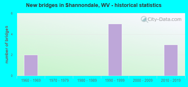
- New bridges - historical statistics
- 21960-1969
- 51990-1999
- 32010-2019

- Reconstructed bridges - Historical Statistics
- 11990-1999
- 22000-2009
- 12010-2019


- Bridge Condition - Deck
- 14.3%Very good
- 28.6%Good
- 57.1%Satisfactory

- Bridge Condition - Superstructure
- 12.5%Very good
- 37.5%Good
- 50.0%Satisfactory

- Bridge Condition - Substructure
- 25.0%Good
- 62.5%Satisfactory
- 12.5%Fair

- Bridge Condition - Channel
- 14.3%Excellent
- 57.1%Good
- 14.3%Satisfactory
- 14.3%Fair
Find on map >> Show street view
Structure Number: 19A021, Location: 0.54 MI N OF CR 9/5 SLS (Lat: 39.212031, Lng: -77.815681), Route carried "on" structure: County highway 914, Year Built: 1966, Year Reconstructed: 1990, Status: Open, Structure Length: 1.11m (3.64ft), Average Daily Traffic: 90 (year 2020), Average Future Daily Traffic: 160 (year 2040), Design Load: HS 20, Features Intersected: SHANNONDALE LK. SPILLWAY, Facility Carried by Structure: CR 9/14 SLS
Minimum Vertical Clearance: 30+ m (98+ ft), Kilometerpoint: 2.816, Lanes on structure: 1, Owner: State Highway Agency, Approaching Roadway Width: 6.1m (20.0ft), Material/Design: Wood or Timber, Design/Construction: Slab, Number Of Spans In Main Unit: 1, Number Of Approach Spans: 2, Length of Maximum Span: 3.5m (11.5ft), Curb-To-Curb Width: 4.8m (15.7ft), Out-to-Out Width: 5.5m (18.0ft)
Condition: Deck: Satisfactory, Superstructure: Satisfactory, Substructure: Satisfactory, Channel: Good, Operating Rating: 45.4 metric tons, Method Used To Determine Operating Rating: Field evaluation and documented engineering judgment, Inventory Rating: 32.7 metric tons, Method Used To Determine Inventory Rating: Field evaluation and documented engineering judgment, Structural Evaluation: Equal to present minimum criteria, Deck Geometry: Equal to present desirable criteria, Waterway Adequacy: Better than present minimum criteria, Approach Roadway Alignment: Better than present minimum criteria, Length Of Structure Improvement: 1.01m (3.31ft), Designated Inspection Frequency: Every 24 months, Inspection Date: December 2021, Bridge Improvement Cost: $65,000, Roadway Improvement Cost: $10,000, Total Project Cost: $75,000, Deck Structure Type: Wood or Timber, Wearing Surface/Protective System: Wearing Surface: Bituminous
Find on map >> Show street view
Structure Number: 19A035, Location: 0.40 MI S OF CR 25/4 SLS (Lat: 39.216061, Lng: -77.856539), Route carried "on" structure: County highway 2500, Year Built: 1997, Status: Open, Structure Length: 2.65m (8.69ft), Average Daily Traffic: 800 (year 2018), Truck Traffic: 6%, Average Future Daily Traffic: 968 (year 2038), Design Load: HS 25 or greater, Features Intersected: BULLSKIN RUN, Facility Carried by Structure: CR 25 SLS
Minimum Vertical Clearance: 30+ m (98+ ft), Kilometerpoint: 6.276, Lanes on structure: 2, Owner: State Highway Agency, Approaching Roadway Width: 6.1m (20.0ft), Skew: 4 degrees, Material/Design: Prestressed concrete, Design/Construction: Box Beam or Girders - Multiple, Number Of Spans In Main Unit: 2, Length of Maximum Span: 12.0m (39.4ft), Curb-To-Curb Width: 8.0m (26.2ft), Out-to-Out Width: 8.3m (27.2ft)
Condition: Deck: Satisfactory, Superstructure: Satisfactory, Substructure: Satisfactory, Channel: Satisfactory, Operating Rating: 69.8 metric tons, Method Used To Determine Operating Rating: Load Factor (LF), Inventory Rating: 41.7 metric tons, Method Used To Determine Inventory Rating: Load Factor (LF), Structural Evaluation: Equal to present minimum criteria, Deck Geometry: Somewhat better than minimum adequacy, Waterway Adequacy: Equal to present minimum criteria, Approach Roadway Alignment: Meets minimum limits, Designated Inspection Frequency: Every 48 months, Inspection Date: March 2020, Deck Structure Type: Other, Wearing Surface/Protective System: Wearing Surface: Bituminous, Deck Protection: Epoxy Coated Reinforcing
Find on map >> Show street view
Structure Number: 19A036, Location: 0.13 MI S OF CR 9/4 SLS (Lat: 39.219619, Lng: -77.815939), Route carried "on" structure: County highway 905, Year Built: 1998, Status: Open, Structure Length: 1.75m (5.74ft), Average Daily Traffic: 5,700 (year 2018), Truck Traffic: 6%, Average Future Daily Traffic: 7,581 (year 2038), Design Load: HS 25 or greater, Features Intersected: FURNACE RUN, Facility Carried by Structure: CO 9/5 SLS
Minimum Vertical Clearance: 30+ m (98+ ft), Kilometerpoint: 10.847, Lanes on structure: 2, Owner: State Highway Agency, Approaching Roadway Width: 9.8m (32.2ft), Skew: 4 degrees, Material/Design: Prestressed concrete, Design/Construction: Box Beam or Girders - Multiple, Number Of Spans In Main Unit: 1, Length of Maximum Span: 15.9m (52.2ft), Curb-To-Curb Width: 8.0m (26.2ft), Out-to-Out Width: 8.3m (27.2ft)
Condition: Deck: Satisfactory, Superstructure: Satisfactory, Substructure: Satisfactory, Channel: Fair, Operating Rating: 63.5 metric tons, Method Used To Determine Operating Rating: Load Factor (LF), Inventory Rating: 38.1 metric tons, Method Used To Determine Inventory Rating: Load Factor (LF), Structural Evaluation: Equal to present minimum criteria, Deck Geometry: High priority of replacement, Waterway Adequacy: Equal to present minimum criteria, Approach Roadway Alignment: Better than present minimum criteria, Designated Inspection Frequency: Every 24 months, Inspection Date: April 2020, Deck Structure Type: Other, Wearing Surface/Protective System: Wearing Surface: Bituminous, Deck Protection: Epoxy Coated Reinforcing
Find on map >> Show street view
Structure Number: 19A056, Location: 0.04 MI W OF CR 25/11 SLS (Lat: 39.211661, Lng: -77.834850), Route carried "on" structure: County highway 2514, Year Built: 1990, Year Reconstructed: 2011, Status: Open, Structure Length: 1.64m (5.38ft), Average Daily Traffic: 400 (year 2019), Truck Traffic: 6%, Average Future Daily Traffic: 484 (year 2039), Design Load: HS 25 or greater, Features Intersected: BULLSKIN RUN, Facility Carried by Structure: CR 25/14 SLS
Minimum Vertical Clearance: 30+ m (98+ ft), Kilometerpoint: 2.414, Lanes on structure: 2, Owner: State Highway Agency, Approaching Roadway Width: 4.6m (15.1ft), Skew: 1 degrees, Material/Design: Prestressed concrete, Design/Construction: Box Beam or Girders - Multiple, Number Of Spans In Main Unit: 1, Length of Maximum Span: 15.2m (49.9ft), Curb-To-Curb Width: 6.4m (21.0ft), Out-to-Out Width: 6.4m (21.0ft)
Condition: Deck: Good, Superstructure: Good, Substructure: Good, Channel: Good, Operating Rating: 80.7 metric tons, Method Used To Determine Operating Rating: Load Factor (LF), Inventory Rating: 48.1 metric tons, Method Used To Determine Inventory Rating: Load Factor (LF), Structural Evaluation: Better than present minimum criteria, Deck Geometry: Meets minimum limits, Waterway Adequacy: Better than present minimum criteria, Approach Roadway Alignment: Equal to present minimum criteria, Designated Inspection Frequency: Every 48 months, Inspection Date: April 2021, Deck Structure Type: Other, Wearing Surface/Protective System: Deck Protection: Epoxy Coated Reinforcing
Find on map >> Show street view
Structure Number: 19A057, Location: 0.04 MI NORTH OF CR 25/11 (Lat: 39.214800, Lng: -77.842269), Route carried "on" structure: County highway 2505, Year Built: 1993, Year Reconstructed: 2011, Status: Open, Structure Length: 1.03m (3.38ft), Average Daily Traffic: 150 (year 2020), Truck Traffic: 6%, Average Future Daily Traffic: 182 (year 2040), Design Load: HS 25 or greater, Features Intersected: BULLSKIN RUN, Facility Carried by Structure: CR 25/5 SLS
Minimum Vertical Clearance: 30+ m (98+ ft), Kilometerpoint: 2.800, Lanes on structure: 2, Owner: State Highway Agency, Approaching Roadway Width: 6.1m (20.0ft), Material/Design: Prestressed concrete, Design/Construction: Box Beam or Girders - Multiple, Number Of Spans In Main Unit: 1, Length of Maximum Span: 9.1m (29.9ft), Curb-To-Curb Width: 7.3m (24.0ft), Out-to-Out Width: 7.4m (24.3ft)
Condition: Deck: Good, Superstructure: Good, Substructure: Satisfactory, Channel: Good, Operating Rating: 73.5 metric tons, Method Used To Determine Operating Rating: Load Factor (LF), Inventory Rating: 44.4 metric tons, Method Used To Determine Inventory Rating: Load Factor (LF), Structural Evaluation: Equal to present minimum criteria, Deck Geometry: Somewhat better than minimum adequacy, Waterway Adequacy: Equal to present minimum criteria, Approach Roadway Alignment: Somewhat better than minimum adequacy, Designated Inspection Frequency: Every 48 months, Inspection Date: June 2021, Deck Structure Type: Other, Wearing Surface/Protective System: Wearing Surface: Bituminous, Deck Protection: Epoxy Coated Reinforcing
Find on map >> Show street view
Structure Number: 19A059, Location: Over the Shenandoah River (Lat: 39.270911, Lng: -77.781850), Route carried "on" structure: State highway 9, Year Built: 2012, Status: Open, Structure Length: 50.42m (165.42ft), Average Daily Traffic: 17,702 (year 2018), Truck Traffic: 5%, Average Future Daily Traffic: 23,190 (year 2038), Design Load: HL 93, Features Intersected: Shen.Rvr;Race;AccsRd
Minimum Vertical Clearance: 30+ m (98+ ft), Kilometerpoint: 21.758, Lanes on structure: 4, Base Highway Network: Yes, Owner: State Highway Agency, Approaching Roadway Width: 11.6m (38.1ft), Material/Design: Steel continuous, Design/Construction: Frame, Number Of Spans In Main Unit: 5, Number Of Approach Spans: 2, Length of Maximum Span: 182.9m (600.1ft), Curb-To-Curb Width: 12.1m (39.7ft), Out-to-Out Width: 25.7m (84.3ft)
Condition: Deck: Satisfactory, Superstructure: Good, Substructure: Good, Channel: Excellent, Operating Rating: 42.6 metric tons, Method Used To Determine Operating Rating: Assigned ratings based on Load and Resistance Factor Design (LRFD) reported in metric tons, Inventory Rating: 32.7 metric tons, Method Used To Determine Inventory Rating: Assigned ratings based on Load and Resistance Factor Design (LRFD) reported in metric tons, Structural Evaluation: Better than present minimum criteria, Deck Geometry: High priority of replacement, Waterway Adequacy: Equal to present desirable criteria, Approach Roadway Alignment: Equal to present desirable criteria, Length Of Structure Improvement: 50.42m (165.42ft), Designated Inspection Frequency: Every 24 months, Inspection Date: September 2020, Bridge Improvement Cost: $80,000, Total Project Cost: $80,000 ( Estimate for 2014), Deck Structure Type: Concrete Cast-file-Place
Find on map >> Show street view
Structure Number: 19A062, Location: 1.12 miles west of CR 32 (Lat: 39.271261, Lng: -77.779261), Route carried "on" structure: State highway 900, Year Built: 2011, Status: Open, Structure Length: 0.73m (2.40ft), Average Daily Traffic: 16,800 (year 2019), Truck Traffic: 4%, Average Future Daily Traffic: 23,016 (year 2039), Design Load: HL 93, Features Intersected: Private Land access Road, Facility Carried by Structure: WV 09 (T)
Minimum Vertical Clearance: 30+ m (98+ ft), Kilometerpoint: 22.273, Lanes on structure: 4, Lanes under structure: 2, Base Highway Network: Yes, Owner: State Highway Agency, Approaching Roadway Width: 12.2m (40.0ft), Skew: 30 degrees, Material/Design: Concrete, Design/Construction: Arch - Deck, Number Of Spans In Main Unit: 1, Length of Maximum Span: 7.3m (24.0ft), Curb-To-Curb Width: 12.2m (40.0ft), Out-to-Out Width: 31.7m (104.0ft)
Condition: Superstructure: Satisfactory, Substructure: Satisfactory, Operating Rating: 88.9 metric tons, Method Used To Determine Operating Rating: Field evaluation and documented engineering judgment, Inventory Rating: 40.8 metric tons, Method Used To Determine Inventory Rating: Field evaluation and documented engineering judgment, Structural Evaluation: Equal to present minimum criteria, Deck Geometry: High priority of replacement, Approach Roadway Alignment: Better than present minimum criteria, Designated Inspection Frequency: Every 24 months, Inspection Date: March 2021
Find on map >> Show street view
Structure Number: 19A066, Location: 0.05 mile north CR 25/7 (Lat: 39.184239, Lng: -77.875411), Route carried "on" structure: County highway 25, Year Built: 1968, Year Reconstructed: 2016, Status: Open, Structure Length: 1.66m (5.45ft), Average Daily Traffic: 350 (year 2018), Truck Traffic: 6%, Average Future Daily Traffic: 466 (year 2038), Design Load: HL 93, Features Intersected: Long Marsh Run
Minimum Vertical Clearance: 30+ m (98+ ft), Kilometerpoint: 2.269, Lanes on structure: 2, Owner: State Highway Agency, Approaching Roadway Width: 6.7m (22.0ft), Skew: 1 degrees, Material/Design: Prestressed concrete, Design/Construction: Box Beam or Girders - Multiple, Number Of Spans In Main Unit: 1, Length of Maximum Span: 15.6m (51.2ft), Curb-To-Curb Width: 7.3m (24.0ft), Out-to-Out Width: 7.3m (24.0ft)
Condition: Deck: Very good, Superstructure: Very good, Substructure: Fair, Channel: Good, Operating Rating: 56.2 metric tons, Method Used To Determine Operating Rating: Load and Resistance Factor (LRFR), Inventory Rating: 43.5 metric tons, Method Used To Determine Inventory Rating: Load and Resistance Factor (LRFR), Structural Evaluation: Somewhat better than minimum adequacy, Deck Geometry: Somewhat better than minimum adequacy, Waterway Adequacy: Equal to present desirable criteria, Approach Roadway Alignment: Equal to present desirable criteria, Designated Inspection Frequency: Every 24 months, Inspection Date: June 2020, Wearing Surface/Protective System: Wearing Surface: Bituminous, Deck Protection: Epoxy Coated Reinforcing
Find on map >> Show street view
Structure Number: 19A004, Location: 0.01 MI W OFCR 9/8 SLS (Lat: 39.254314, Lng: -77.814606), Route carried "under" structure: County highway 908, Year Built: 1990, Structure Length: 0. m, Average Daily Traffic: 103 (year 0015), Features Intersected: Shenandoah River & CR9/8, Facility Carried by Structure: WV 115 (F)
Minimum Vertical Clearance: 10.67m (35.01ft), Kilometerpoint: 0.274, Lanes on structure: 2, Lanes under structure: 2, Length of Maximum Span: 76.2m (250.0ft)
Find on map >> Show street view
Structure Number: 19A062, Location: 1.12 miles west of CR 32 (Lat: 39.271261, Lng: -77.792611), Route carried "under" structure: Other road , Year Built: 2011, Structure Length: 0. m, Average Daily Traffic: 10 (year 2021), Features Intersected: Private Land access Road, Facility Carried by Structure: WV 09 (T)
Minimum Vertical Clearance: 4.27m (14.01ft), Kilometerpoint: 0.209, Lanes on structure: 4, Lanes under structure: 2, Length of Maximum Span: 7.3m (24.0ft)