Bridge Statistics for Shanksville, Pennsylvania (PA)
Condition, Traffic, Stress, Structural Evaluation, Project Costs
- National Bridge Inventory (NBI) Statistics
- 25Number of bridges
- 200ft / 60.6mTotal length
- $10,887,000Total costs
- 317,774Total average daily traffic
- 106,826Total average daily truck traffic
- National Bridge Inventory (NBI) Registered Bridges for Shanksville
- No street view available for this location
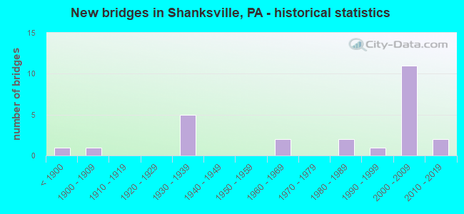
- New bridges - historical statistics
- 1Before 1900
- 11900-1909
- 51930-1939
- 21960-1969
- 21980-1989
- 11990-1999
- 112000-2009
- 22010-2019

- Reconstructed bridges - Historical Statistics
- 11980-1989
- 51990-1999
- 12000-2009


- Bridge Condition - Deck
- 6.3%Excellent
- 12.5%Very good
- 50.0%Good
- 18.8%Satisfactory
- 6.3%Fair
- 6.3%Poor

- Bridge Condition - Superstructure
- 25.0%Very good
- 37.5%Good
- 12.5%Satisfactory
- 18.8%Fair
- 6.3%Poor

- Bridge Condition - Substructure
- 18.8%Very good
- 37.5%Good
- 31.3%Satisfactory
- 6.3%Fair
- 6.3%Poor

- Bridge Condition - Channel
- 13.3%Very good
- 6.7%Good
- 26.7%Satisfactory
- 40.0%Fair
- 13.3%Poor

- Bridge Condition - Culverts
- 25.0%Good
- 25.0%Satisfactory
- 50.0%Fair
Find on map >> Show street view
Structure Number: 3151, Location: RAYBURN TWP-N KITTANNING (Lat: 40.827239, Lng: -79.493431), Route carried "on" structure: State highway , Year Built: 1962, Status: Open, Structure Length: 3.41m (11.19ft), Average Daily Traffic: 888 (year 2020), Truck Traffic: 5%, Average Future Daily Traffic: 916 (year 2032), Design Load: HS 20, Features Intersected: COWANSHANNOCK CREEK, Facility Carried by Structure: SR1036
Minimum Vertical Clearance: 30+ m (98+ ft), Kilometerpoint: 2.343, Lanes on structure: 2, Owner: State Highway Agency, Approaching Roadway Width: 6.7m (22.0ft), Skew: 2 degrees, Material/Design: Prestressed concrete, Design/Construction: Box Beam or Girders - Single/Spread, Number Of Spans In Main Unit: 2, Length of Maximum Span: 16.5m (54.1ft), Curb or Sidewalk Widths: Left: 0.5m (1.6ft), Right: 0.5m (1.6ft), Curb-To-Curb Width: 9.1m (29.9ft), Out-to-Out Width: 10.9m (35.8ft)
Condition: Deck: Poor, Superstructure: Fair, Substructure: Poor, Channel: Poor, Operating Rating: 91.6 metric tons, Method Used To Determine Operating Rating: Load Factor (LF), Inventory Rating: 46.3 metric tons, Method Used To Determine Inventory Rating: Load Factor (LF), Structural Evaluation: Meets minimum limits, Deck Geometry: Equal to present minimum criteria, Waterway Adequacy: Better than present minimum criteria, Approach Roadway Alignment: Better than present minimum criteria, Length Of Structure Improvement: 4.90m (16.08ft), Designated Inspection Frequency: Every 24 months, Inspection Date: April 2020, Bridge Improvement Cost: $36,000, Roadway Improvement Cost: $107,000, Total Project Cost: $489,000, Deck Structure Type: Concrete Cast-file-Place, Wearing Surface/Protective System: Wearing Surface: Bituminous
Find on map >> Show street view
Structure Number: 8458, Location: 0.4 MILE NORTH OF TR 869 (Lat: 40.349325, Lng: -78.776372), Route carried "on" structure: US 219, Year Built: 1968, Year Reconstructed: 2009, Status: Open, Structure Length: 15.06m (49.41ft), Average Daily Traffic: 15,540 (year 2022), Truck Traffic: 8%, Average Future Daily Traffic: 19,975 (year 2032), Design Load: HS 20, Features Intersected: S FORK L CONE RIVER & RR
Minimum Vertical Clearance: 30+ m (98+ ft), Kilometerpoint: 15.075, Lanes on structure: 2, Base Highway Network: Yes, Owner: State Highway Agency, Approaching Roadway Width: 9.8m (32.2ft), Skew: 32 degrees, Material/Design: Steel continuous, Design/Construction: Stringer/Multi-beam, Number Of Spans In Main Unit: 4, Length of Maximum Span: 41.8m (137.1ft), Curb or Sidewalk Widths: Left: 0.2m (0.7ft), Right: 0.2m (0.7ft), Curb-To-Curb Width: 9.6m (31.5ft), Out-to-Out Width: 21.2m (69.6ft)
Condition: Deck: Good, Superstructure: Good, Substructure: Satisfactory, Channel: Very good, Operating Rating: 52.6 metric tons, Method Used To Determine Operating Rating: Load Factor (LF), Inventory Rating: 31.8 metric tons, Method Used To Determine Inventory Rating: Load Factor (LF), Structural Evaluation: Equal to present minimum criteria, Deck Geometry: Meets minimum limits, Underclear: High priority of corrective action, Waterway Adequacy: Superior to present desirable criteria, Approach Roadway Alignment: Equal to present desirable criteria, Length Of Structure Improvement: 15.90m (52.17ft), Designated Inspection Frequency: Every 24 months, Inspection Date: September 2021, Deck Structure Type: Concrete Cast-file-Place, Wearing Surface/Protective System: Wearing Surface: Latex Concrete
Find on map >> Show street view
Structure Number: 3151, Location: SHANKSVILLE BORO (Lat: 40.016639, Lng: -78.908314), Route carried "on" structure: State highway , Year Built: 1989, Status: Open, Structure Length: 2.99m (9.81ft), Average Daily Traffic: 2,494 (year 2020), Truck Traffic: 2%, Average Future Daily Traffic: 2,780 (year 2032), Design Load: HS 25 or greater, Features Intersected: STONY CREEK, Facility Carried by Structure: SR 1001
Minimum Vertical Clearance: 30+ m (98+ ft), Kilometerpoint: 10.383, Lanes on structure: 2, Owner: State Highway Agency, Approaching Roadway Width: 8.5m (27.9ft), Material/Design: Prestressed concrete, Design/Construction: Box Beam or Girders - Multiple, Number Of Spans In Main Unit: 2, Length of Maximum Span: 14.3m (46.9ft), Curb or Sidewalk Widths: Left: 0.2m (0.7ft), Right: 1.9m (6.2ft), Curb-To-Curb Width: 8.5m (27.9ft), Out-to-Out Width: 11.1m (36.4ft)
Condition: Deck: Satisfactory, Superstructure: Good, Substructure: Fair, Channel: Poor, Operating Rating: 93.4 metric tons, Method Used To Determine Operating Rating: Load Factor (LF), Inventory Rating: 41.7 metric tons, Method Used To Determine Inventory Rating: Load Factor (LF), Structural Evaluation: Somewhat better than minimum adequacy, Deck Geometry: Meets minimum limits, Waterway Adequacy: Equal to present desirable criteria, Approach Roadway Alignment: Better than present minimum criteria, Length Of Structure Improvement: 3.70m (12.14ft), Designated Inspection Frequency: Every 24 months, Inspection Date: Febuary 2021, Deck Structure Type: Concrete Cast-file-Place, Wearing Surface/Protective System: Wearing Surface: Monolithic Concrete, Deck Protection: Epoxy Coated Reinforcing
Find on map >> Show street view
Structure Number: 31655, Location: 3 MI.W.OF ROXBURY (Lat: 39.976633, Lng: -78.930383), Route carried "on" structure: State highway , Year Built: 1996, Status: Open, Structure Length: 1.25m (4.10ft), Average Daily Traffic: 441 (year 2022), Truck Traffic: 4%, Average Future Daily Traffic: 180 (year 2032), Design Load: HS 25 or greater, Features Intersected: GLADES CREEK, Facility Carried by Structure: SR 2033
Minimum Vertical Clearance: 30+ m (98+ ft), Kilometerpoint: 7.199, Lanes on structure: 2, Owner: State Highway Agency, Approaching Roadway Width: 10.1m (33.1ft), Material/Design: Concrete, Design/Construction: Culvert, Number Of Spans In Main Unit: 2, Length of Maximum Span: 6.1m (20.0ft), Curb-To-Curb Width: 10.1m (33.1ft), Out-to-Out Width: 11.1m (36.4ft)
Condition: Channel: Satisfactory, Culverts: Good, Operating Rating: 84.4 metric tons, Method Used To Determine Operating Rating: Load Factor (LF), Inventory Rating: 50.8 metric tons, Method Used To Determine Inventory Rating: Load Factor (LF), Structural Evaluation: Better than present minimum criteria, Deck Geometry: Equal to present minimum criteria, Waterway Adequacy: Better than present minimum criteria, Approach Roadway Alignment: Equal to present desirable criteria, Length Of Structure Improvement: 1.90m (6.23ft), Designated Inspection Frequency: Every 48 months, Inspection Date: Febuary 2019, Wearing Surface/Protective System: Wearing Surface: Bituminous, Membrane: Preformed Fabric, Deck Protection: Epoxy Coated Reinforcing
Find on map >> Show street view
Structure Number: 31814, Location: NEAR BROTHERTON (Lat: 39.983333, Lng: -78.951667), Route carried "on" structure: Interstate 76, Year Built: 2004, Status: Open, Structure Length: 0.79m (2.59ft), Average Daily Traffic: 29,452 (year 1999), Truck Traffic: 36%, Average Future Daily Traffic: 34,324 (year 2030), Design Load: HL 93, Features Intersected: GLADES CREEK
Minimum Vertical Clearance: 30+ m (98+ ft), Kilometerpoint: 0.000, Lanes on structure: 2, Base Highway Network: Yes, Toll: On toll road, Owner: State Toll Authority, Approaching Roadway Width: 13.7m (44.9ft), Skew: 30 degrees, Material/Design: Prestressed concrete, Design/Construction: Box Beam or Girders - Single/Spread, Number Of Spans In Main Unit: 1, Length of Maximum Span: 7.3m (24.0ft), Curb or Sidewalk Widths: Left: 0.2m (0.7ft), Right: 0.2m (0.7ft), Curb-To-Curb Width: 13.7m (44.9ft), Out-to-Out Width: 30.3m (99.4ft)
Condition: Deck: Very good, Superstructure: Good, Substructure: Good, Channel: Satisfactory, Operating Rating: 81.6 metric tons, Method Used To Determine Operating Rating: Load and Resistance Factor (LRFR), Inventory Rating: 49.0 metric tons, Method Used To Determine Inventory Rating: Load and Resistance Factor (LRFR), Structural Evaluation: Better than present minimum criteria, Deck Geometry: Superior to present desirable criteria, Waterway Adequacy: Superior to present desirable criteria, Approach Roadway Alignment: Equal to present desirable criteria, Length Of Structure Improvement: 1.40m (4.59ft), Designated Inspection Frequency: Every 48 months, Inspection Date: April 2019, Bridge Improvement Cost: $28,000, Roadway Improvement Cost: $83,000, Total Project Cost: $381,000, Deck Structure Type: Concrete Cast-file-Place, Wearing Surface/Protective System: Wearing Surface: Monolithic Concrete, Deck Protection: Epoxy Coated Reinforcing
Find on map >> Show street view
Structure Number: 31817, Location: WEST OF ALLEGHENY TUNNEL (Lat: 39.973333, Lng: -78.925000), Route carried "on" structure: Interstate 76, Year Built: 2004, Status: Open, Structure Length: 1.55m (5.09ft), Average Daily Traffic: 29,452 (year 1999), Truck Traffic: 36%, Average Future Daily Traffic: 34,324 (year 2030), Design Load: HL 93, Features Intersected: SR 2033(LR 55046)
Minimum Vertical Clearance: 30+ m (98+ ft), Kilometerpoint: 0.000, Lanes on structure: 2, Lanes under structure: 2, Base Highway Network: Yes, Toll: On toll road, Owner: State Toll Authority, Approaching Roadway Width: 13.7m (44.9ft), Skew: 30 degrees, Material/Design: Prestressed concrete, Design/Construction: Box Beam or Girders - Single/Spread, Number Of Spans In Main Unit: 1, Length of Maximum Span: 14.9m (48.9ft), Curb or Sidewalk Widths: Left: 0.2m (0.7ft), Right: 0.2m (0.7ft), Curb-To-Curb Width: 13.4m (44.0ft), Out-to-Out Width: 30.3m (99.4ft)
Condition: Deck: Good, Superstructure: Good, Substructure: Satisfactory, Operating Rating: 49.9 metric tons, Method Used To Determine Operating Rating: Load Factor (LF), Inventory Rating: 29.9 metric tons, Method Used To Determine Inventory Rating: Load Factor (LF), Structural Evaluation: Equal to present minimum criteria, Deck Geometry: Superior to present desirable criteria, Underclear: Meets minimum limits, Approach Roadway Alignment: Equal to present desirable criteria, Length Of Structure Improvement: 2.10m (6.89ft), Designated Inspection Frequency: Every 24 months, Inspection Date: April 2021, Bridge Improvement Cost: $101,000, Roadway Improvement Cost: $298,000, Total Project Cost: $1,367,000, Wearing Surface/Protective System: Wearing Surface: Monolithic Concrete, Deck Protection: Epoxy Coated Reinforcing
Find on map >> Show street view
Structure Number: 31818, Location: EAST OF BROTHERTON (Lat: 39.975939, Lng: -78.921428), Route carried "on" structure: Interstate 76, Year Built: 1939, Year Reconstructed: 2004, Status: Open, Structure Length: 1.04m (3.41ft), Average Daily Traffic: 29,452 (year 1999), Truck Traffic: 36%, Average Future Daily Traffic: 34,324 (year 2030), Design Load: HS 20+Mod, Features Intersected: SANDY HOLLOW CREEK
Minimum Vertical Clearance: 30+ m (98+ ft), Kilometerpoint: 0.000, Lanes on structure: 4, Base Highway Network: Yes, Toll: On toll road, Owner: State Toll Authority, Approaching Roadway Width: 29.3m (96.1ft), Skew: 33 degrees, Material/Design: Concrete, Design/Construction: Culvert, Number Of Spans In Main Unit: 2, Length of Maximum Span: 10.4m (34.1ft)
Condition: Channel: Fair, Culverts: Fair, Operating Rating: 89.8 metric tons, Method Used To Determine Operating Rating: Field evaluation and documented engineering judgment, Inventory Rating: 89.8 metric tons, Method Used To Determine Inventory Rating: Field evaluation and documented engineering judgment, Structural Evaluation: Somewhat better than minimum adequacy, Waterway Adequacy: Superior to present desirable criteria, Approach Roadway Alignment: Equal to present desirable criteria, Length Of Structure Improvement: 1.90m (6.23ft), Designated Inspection Frequency: Every 24 months, Inspection Date: April 2021, Bridge Improvement Cost: $31,000, Roadway Improvement Cost: $92,000, Total Project Cost: $420,000
Find on map >> Show street view
Structure Number: 31819, Location: NEAR BROTHERTON (Lat: 39.971667, Lng: -78.908333), Route carried "on" structure: Interstate 76, Year Built: 2004, Status: Open, Structure Length: 2.90m (9.51ft), Average Daily Traffic: 29,452 (year 1999), Truck Traffic: 36%, Average Future Daily Traffic: 42,630 (year 2030), Design Load: HL 93, Features Intersected: STONYCREEK RIVER
Minimum Vertical Clearance: 30+ m (98+ ft), Kilometerpoint: 0.000, Lanes on structure: 2, Base Highway Network: Yes, Toll: On toll road, Owner: State Toll Authority, Approaching Roadway Width: 14.6m (47.9ft), Skew: 30 degrees, Material/Design: Steel continuous, Design/Construction: Stringer/Multi-beam, Number Of Spans In Main Unit: 2, Length of Maximum Span: 14.3m (46.9ft), Curb-To-Curb Width: 14.6m (47.9ft), Out-to-Out Width: 30.3m (99.4ft)
Condition: Deck: Satisfactory, Superstructure: Good, Substructure: Good, Channel: Fair, Inventory Rating: 71.7 metric tons, Method Used To Determine Inventory Rating: Load Factor (LF), Structural Evaluation: Better than present minimum criteria, Deck Geometry: Superior to present desirable criteria, Waterway Adequacy: Superior to present desirable criteria, Approach Roadway Alignment: Equal to present desirable criteria, Length Of Structure Improvement: 3.90m (12.80ft), Designated Inspection Frequency: Every 24 months, Underwater Inspection Frequency: Every 48 months, Inspection Date: April 2021, Underwater Inspection Date: June 2019, Bridge Improvement Cost: $246,000, Roadway Improvement Cost: $725,000, Total Project Cost: $3,324,000, Deck Structure Type: Concrete Cast-file-Place, Wearing Surface/Protective System: Wearing Surface: Monolithic Concrete, Deck Protection: Epoxy Coated Reinforcing
Find on map >> Show street view
Structure Number: 31821, Location: WEST OF ALLEGHENY TUNNEL (Lat: 39.970000, Lng: -78.900000), Route carried "on" structure: Interstate 76, Year Built: 1939, Year Reconstructed: 2004, Status: Open, Structure Length: 0.73m (2.40ft), Average Daily Traffic: 29,452 (year 1999), Truck Traffic: 36%, Average Future Daily Traffic: 34,324 (year 2030), Design Load: HS 20, Features Intersected: TRIB. TO STONEY CREEK
Minimum Vertical Clearance: 30+ m (98+ ft), Kilometerpoint: 0.000, Lanes on structure: 4, Base Highway Network: Yes, Toll: On toll road, Owner: State Toll Authority, Approaching Roadway Width: 29.3m (96.1ft), Skew: 30 degrees, Material/Design: Concrete, Design/Construction: Culvert, Number Of Spans In Main Unit: 1, Length of Maximum Span: 7.3m (24.0ft)
Condition: Channel: Satisfactory, Culverts: Fair, Operating Rating: 89.8 metric tons, Method Used To Determine Operating Rating: Field evaluation and documented engineering judgment, Inventory Rating: 32.7 metric tons, Method Used To Determine Inventory Rating: Field evaluation and documented engineering judgment, Structural Evaluation: Somewhat better than minimum adequacy, Waterway Adequacy: Superior to present desirable criteria, Approach Roadway Alignment: Equal to present desirable criteria, Length Of Structure Improvement: 1.40m (4.59ft), Designated Inspection Frequency: Every 24 months, Inspection Date: April 2021, Bridge Improvement Cost: $28,000, Roadway Improvement Cost: $83,000, Total Project Cost: $381,000
Find on map >> Show street view
Structure Number: 31823, Location: WEST OF ALLEGHENY TUNNEL (Lat: 39.970000, Lng: -78.890000), Route carried "on" structure: Interstate 76, Year Built: 1939, Year Reconstructed: 2004, Status: Open, Structure Length: 0.98m (3.22ft), Average Daily Traffic: 29,452 (year 1999), Truck Traffic: 36%, Average Future Daily Traffic: 34,324 (year 2030), Design Load: HS 20, Features Intersected: TRIB. TO STONY CREEK
Minimum Vertical Clearance: 30+ m (98+ ft), Kilometerpoint: 0.000, Lanes on structure: 4, Base Highway Network: Yes, Toll: On toll road, Owner: State Toll Authority, Approaching Roadway Width: 29.3m (96.1ft), Skew: 30 degrees, Material/Design: Concrete, Design/Construction: Culvert, Number Of Spans In Main Unit: 1, Length of Maximum Span: 6.7m (22.0ft)
Condition: Channel: Fair, Culverts: Satisfactory, Operating Rating: 89.8 metric tons, Method Used To Determine Operating Rating: Load Factor (LF), Inventory Rating: 89.8 metric tons, Method Used To Determine Inventory Rating: Load Factor (LF), Structural Evaluation: Equal to present minimum criteria, Waterway Adequacy: Superior to present desirable criteria, Approach Roadway Alignment: Equal to present desirable criteria, Length Of Structure Improvement: 1.60m (5.25ft), Designated Inspection Frequency: Every 48 months, Inspection Date: April 2019, Bridge Improvement Cost: $80,000, Roadway Improvement Cost: $237,000, Total Project Cost: $1,085,000
Find on map >> Show street view
Structure Number: 31824, Location: WEST OF ALLEGHENY TUNNEL (Lat: 39.968333, Lng: -78.871667), Route carried "on" structure: Other road 76, Year Built: 1939, Year Reconstructed: 2003, Status: Open, Structure Length: 2.16m (7.09ft), Average Daily Traffic: 29,452 (year 1999), Truck Traffic: 36%, Average Future Daily Traffic: 34,323 (year 2030), Design Load: HS 25 or greater, Features Intersected: SR 0160 (LR 55045)
Minimum Vertical Clearance: 30+ m (98+ ft), Kilometerpoint: 0.000, Lanes on structure: 4, Lanes under structure: 2, Base Highway Network: Yes, Toll: On toll road, Owner: State Toll Authority, Approaching Roadway Width: 14.6m (47.9ft), Skew: 32 degrees, Material/Design: Steel, Design/Construction: Stringer/Multi-beam, Number Of Spans In Main Unit: 1, Length of Maximum Span: 21.0m (68.9ft), Curb-To-Curb Width: 14.6m (47.9ft), Out-to-Out Width: 30.3m (99.4ft)
Condition: Deck: Good, Superstructure: Good, Substructure: Satisfactory, Operating Rating: 90.7 metric tons, Method Used To Determine Operating Rating: Load Factor (LF), Inventory Rating: 54.4 metric tons, Method Used To Determine Inventory Rating: Load Factor (LF), Structural Evaluation: Equal to present minimum criteria, Deck Geometry: High priority of replacement, Underclear: Meets minimum limits, Approach Roadway Alignment: Equal to present desirable criteria, Length Of Structure Improvement: 2.80m (9.19ft), Designated Inspection Frequency: Every 48 months, Inspection Date: April 2019, Bridge Improvement Cost: $174,000, Roadway Improvement Cost: $513,000, Total Project Cost: $2,351,000, Deck Structure Type: Concrete Cast-file-Place, Wearing Surface/Protective System: Wearing Surface: Monolithic Concrete, Deck Protection: Epoxy Coated Reinforcing
Find on map >> Show street view
Structure Number: 31899, Location: 3 MI.S.OF SHANKSVILLE (Lat: 39.984975, Lng: -78.914042), Route carried "on" structure: City street , Year Built: 1900, Year Reconstructed: 1991, Status: Posted for load, Structure Length: 2.53m (8.30ft), Average Daily Traffic: 50 (year 2021), Average Future Daily Traffic: 63 (year 2041), Design Load: H 10, Features Intersected: STONYCREEK RIVER, Facility Carried by Structure: T-515, YONAI ROAD
Minimum Vertical Clearance: 30+ m (98+ ft), Kilometerpoint: 0.000, Lanes on structure: 1, Owner: County Highway Agency, Approaching Roadway Width: 4.6m (15.1ft), Material/Design: Steel, Design/Construction: Truss - Thru, Number Of Spans In Main Unit: 1, Length of Maximum Span: 25.0m (82.0ft), Curb or Sidewalk Widths: Left: 0.2m (0.7ft), Right: 0.2m (0.7ft), Curb-To-Curb Width: 3.9m (12.8ft), Out-to-Out Width: 4.3m (14.1ft)
Condition: Deck: Fair, Superstructure: Poor, Substructure: Satisfactory, Channel: Fair, Operating Rating: 12.7 metric tons, Method Used To Determine Operating Rating: Allowable Stress (AS), Inventory Rating: 7.3 metric tons, Method Used To Determine Inventory Rating: Allowable Stress (AS), Structural Evaluation: High priority of replacement, Deck Geometry: Meets minimum limits, Waterway Adequacy: Equal to present desirable criteria, Approach Roadway Alignment: Equal to present minimum criteria, Bridge Posting: Required (Relationship of Operating Rating to Maximum Legal Load: > 39.9% below), Length Of Structure Improvement: 3.20m (10.50ft), Designated Inspection Frequency: Every 24 months, Critical Feature Inspection Frequency: Every 12 months, Other Special Inspection Frequency: Every 12 months, Inspection Date: October 2020, Critical Feature Inspection Date: October 2021, Other Special Inspection Date: October 2021, Bridge Improvement Cost: $81,000, Roadway Improvement Cost: $264,000, Total Project Cost: $1,089,000, Deck Structure Type: Wood or Timber, Wearing Surface/Protective System: Wearing Surface: Wood or Timber
Find on map >> Show street view
Structure Number: 319, Location: 1 MI.S.OF SHANKSVILLE (Lat: 40.003539, Lng: -78.900661), Route carried "on" structure: City street , Year Built: 1989, Status: Open, Structure Length: 1.07m (3.51ft), Average Daily Traffic: 50 (year 2020), Average Future Daily Traffic: 70 (year 2040), Design Load: HS 25 or greater, Features Intersected: STONYCREEK RIVER, Facility Carried by Structure: T539,BALTZER BR RD
Minimum Vertical Clearance: 30+ m (98+ ft), Kilometerpoint: 0.000, Lanes on structure: 2, Owner: Town or Township Highway Agency, Approaching Roadway Width: 7.3m (24.0ft), Skew: 1 degrees, Material/Design: Prestressed concrete, Design/Construction: Box Beam or Girders - Multiple, Number Of Spans In Main Unit: 1, Length of Maximum Span: 10.4m (34.1ft), Curb or Sidewalk Widths: Left: 0.2m (0.7ft), Right: 0.2m (0.7ft), Curb-To-Curb Width: 7.5m (24.6ft), Out-to-Out Width: 8.6m (28.2ft)
Condition: Deck: Satisfactory, Superstructure: Fair, Substructure: Satisfactory, Channel: Fair, Operating Rating: 58.1 metric tons, Method Used To Determine Operating Rating: Load Factor (LF), Inventory Rating: 34.5 metric tons, Method Used To Determine Inventory Rating: Load Factor (LF), Structural Evaluation: Somewhat better than minimum adequacy, Deck Geometry: Equal to present minimum criteria, Waterway Adequacy: Equal to present desirable criteria, Approach Roadway Alignment: Equal to present desirable criteria, Length Of Structure Improvement: 1.80m (5.91ft), Designated Inspection Frequency: Every 24 months, Inspection Date: December 2020, Deck Structure Type: Other, Wearing Surface/Protective System: Wearing Surface: Bituminous
Find on map >> Show street view
Structure Number: 31901, Location: 1.5 MI.NW.OF SHANKSVILLE (Lat: 40.026186, Lng: -78.920847), Route carried "on" structure: City street , Year Built: 1881, Year Reconstructed: 1998, Status: Posted for load, Structure Length: 2.93m (9.61ft), Average Daily Traffic: 50 (year 2021), Average Future Daily Traffic: 70 (year 2041), Design Load: HL 93, Features Intersected: STONYCREEK RIVER, Facility Carried by Structure: T-565, COV.BR.RD.
Minimum Vertical Clearance: 2.97m (9.74ft), Kilometerpoint: 0.000, Lanes on structure: 1, Owner: County Highway Agency, Approaching Roadway Width: 3.7m (12.1ft), Material/Design: Steel, Design/Construction: Stringer/Multi-beam, Number Of Spans In Main Unit: 2, Length of Maximum Span: 12.2m (40.0ft), Curb-To-Curb Width: 3.4m (11.2ft), Out-to-Out Width: 3.4m (11.2ft)
Condition: Deck: Good, Superstructure: Fair, Substructure: Good, Channel: Fair, Operating Rating: 66.2 metric tons, Method Used To Determine Operating Rating: Load Factor (LF), Inventory Rating: 39.9 metric tons, Method Used To Determine Inventory Rating: Load Factor (LF), Structural Evaluation: Somewhat better than minimum adequacy, Deck Geometry: High priority of corrective action, Waterway Adequacy: Equal to present desirable criteria, Approach Roadway Alignment: Meets minimum limits, Length Of Structure Improvement: 3.60m (11.81ft), Designated Inspection Frequency: Every 24 months, Other Special Inspection Frequency: Every 12 months, Inspection Date: July 2020, Other Special Inspection Date: July 2021, Deck Structure Type: Wood or Timber, Wearing Surface/Protective System: Wearing Surface: Wood or Timber
Find on map >> Show street view
Structure Number: 41216, Location: 1 MI.NORTH OF BROTHERTON (Lat: 39.985086, Lng: -78.957642), Route carried "on" structure: State highway , Year Built: 2000, Status: Open, Structure Length: 6.19m (20.31ft), Average Daily Traffic: 892 (year 2020), Truck Traffic: 49%, Average Future Daily Traffic: 957 (year 2032), Design Load: HL 93, Features Intersected: PA TURNPIKE(I-76);B-482, Facility Carried by Structure: SR 1003 (LR55123)
Minimum Vertical Clearance: 30+ m (98+ ft), Kilometerpoint: 6.849, Lanes on structure: 2, Lanes under structure: 5, Owner: State Highway Agency, Approaching Roadway Width: 11.0m (36.1ft), Skew: 2 degrees, Material/Design: Steel, Design/Construction: Stringer/Multi-beam, Number Of Spans In Main Unit: 1, Length of Maximum Span: 60.0m (196.9ft), Curb or Sidewalk Widths: Left: 0.2m (0.7ft), Right: 0.2m (0.7ft), Curb-To-Curb Width: 10.8m (35.4ft), Out-to-Out Width: 11.7m (38.4ft)
Condition: Deck: Good, Superstructure: Satisfactory, Substructure: Good, Operating Rating: 89.8 metric tons, Method Used To Determine Operating Rating: Load Factor (LF), Inventory Rating: 57.2 metric tons, Method Used To Determine Inventory Rating: Load Factor (LF), Structural Evaluation: Equal to present minimum criteria, Deck Geometry: Equal to present minimum criteria, Underclear: High priority of corrective action, Approach Roadway Alignment: Better than present minimum criteria, Length Of Structure Improvement: 7.10m (23.29ft), Designated Inspection Frequency: Every 48 months, Inspection Date: April 2020, Deck Structure Type: Concrete Cast-file-Place, Wearing Surface/Protective System: Wearing Surface: Monolithic Concrete, Deck Protection: Galvanized Reinforcing
Find on map >> Show street view
Structure Number: 41343, Location: 1.8 MI. N.W. OF ROXBURY (Lat: 39.973233, Lng: -78.903994), Route carried "on" structure: State highway , Year Built: 2001, Status: Open, Structure Length: 3.72m (12.20ft), Average Daily Traffic: 221 (year 2020), Truck Traffic: 2%, Average Future Daily Traffic: 283 (year 2032), Design Load: HL 93, Features Intersected: PA TURNPIKE(I-76),B-428, Facility Carried by Structure: SR 1007(LR 55053)
Minimum Vertical Clearance: 30+ m (98+ ft), Kilometerpoint: 1.968, Lanes on structure: 2, Lanes under structure: 4, Owner: State Highway Agency, Approaching Roadway Width: 8.8m (28.9ft), Skew: 2 degrees, Material/Design: Prestressed concrete, Design/Construction: Stringer/Multi-beam, Number Of Spans In Main Unit: 1, Length of Maximum Span: 35.1m (115.2ft), Curb or Sidewalk Widths: Left: 0.2m (0.7ft), Right: 0.2m (0.7ft), Curb-To-Curb Width: 9.0m (29.5ft), Out-to-Out Width: 10.0m (32.8ft)
Condition: Deck: Good, Superstructure: Very good, Substructure: Good, Operating Rating: 77.1 metric tons, Method Used To Determine Operating Rating: Load and Resistance Factor (LRFR), Inventory Rating: 45.4 metric tons, Method Used To Determine Inventory Rating: Load and Resistance Factor (LRFR), Structural Evaluation: Better than present minimum criteria, Deck Geometry: Equal to present minimum criteria, Underclear: Meets minimum limits, Approach Roadway Alignment: Better than present minimum criteria, Length Of Structure Improvement: 4.70m (15.42ft), Designated Inspection Frequency: Every 48 months, Inspection Date: April 2020, Deck Structure Type: Concrete Cast-file-Place, Wearing Surface/Protective System: Wearing Surface: Monolithic Concrete, Deck Protection: Galvanized Reinforcing
Find on map >> Show street view
Structure Number: 41386, Location: NEAR BROTHERTON (Lat: 39.978947, Lng: -78.939547), Route carried "on" structure: State highway , Year Built: 2001, Status: Open, Structure Length: 5.55m (18.21ft), Average Daily Traffic: 314 (year 2021), Truck Traffic: 10%, Average Future Daily Traffic: 381 (year 2032), Design Load: HL 93, Features Intersected: PTC, B-426, MP 118.21, Facility Carried by Structure: SR 1005 (LR 548)
Minimum Vertical Clearance: 30+ m (98+ ft), Kilometerpoint: 1.656, Lanes on structure: 2, Lanes under structure: 4, Owner: State Highway Agency, Approaching Roadway Width: 11.9m (39.0ft), Skew: 2 degrees, Material/Design: Steel, Design/Construction: Stringer/Multi-beam, Number Of Spans In Main Unit: 1, Length of Maximum Span: 53.6m (175.9ft), Curb or Sidewalk Widths: Left: 0.2m (0.7ft), Right: 0.2m (0.7ft), Curb-To-Curb Width: 11.4m (37.4ft), Out-to-Out Width: 12.3m (40.4ft)
Condition: Deck: Good, Superstructure: Satisfactory, Substructure: Good, Operating Rating: 73.5 metric tons, Method Used To Determine Operating Rating: Load and Resistance Factor (LRFR), Inventory Rating: 56.2 metric tons, Method Used To Determine Inventory Rating: Load and Resistance Factor (LRFR), Structural Evaluation: Equal to present minimum criteria, Deck Geometry: Superior to present desirable criteria, Underclear: Equal to present desirable criteria, Approach Roadway Alignment: Better than present minimum criteria, Length Of Structure Improvement: 6.50m (21.33ft), Designated Inspection Frequency: Every 48 months, Inspection Date: April 2020, Deck Structure Type: Concrete Cast-file-Place, Wearing Surface/Protective System: Wearing Surface: Monolithic Concrete, Deck Protection: Galvanized Reinforcing
Find on map >> Show street view
Structure Number: 45246, Location: 1 MI. W. OF SHANKSVILLE (Lat: 40.015919, Lng: -78.923258), Route carried "on" structure: State highway , Year Built: 2008, Status: Open, Structure Length: 1.34m (4.40ft), Average Daily Traffic: 1,731 (year 2022), Truck Traffic: 8%, Average Future Daily Traffic: 2,622 (year 2032), Design Load: HL 93, Features Intersected: SCHROCK RUN, Facility Carried by Structure: SR 1001
Minimum Vertical Clearance: 30+ m (98+ ft), Kilometerpoint: 8.896, Lanes on structure: 2, Owner: State Highway Agency, Approaching Roadway Width: 12.2m (40.0ft), Material/Design: Prestressed concrete, Design/Construction: Box Beam or Girders - Single/Spread, Number Of Spans In Main Unit: 1, Length of Maximum Span: 12.2m (40.0ft), Curb or Sidewalk Widths: Left: 0.1m (0.3ft), Right: 0.1m (0.3ft), Curb-To-Curb Width: 12.2m (40.0ft), Out-to-Out Width: 13.2m (43.3ft)
Condition: Deck: Good, Superstructure: Very good, Substructure: Very good, Channel: Good, Operating Rating: 53.5 metric tons, Method Used To Determine Operating Rating: Load and Resistance Factor (LRFR), Inventory Rating: 40.8 metric tons, Method Used To Determine Inventory Rating: Load and Resistance Factor (LRFR), Structural Evaluation: Equal to present desirable criteria, Deck Geometry: Better than present minimum criteria, Waterway Adequacy: Better than present minimum criteria, Approach Roadway Alignment: Equal to present desirable criteria, Designated Inspection Frequency: Every 48 months, Inspection Date: January 2019, Deck Structure Type: Concrete Cast-file-Place, Wearing Surface/Protective System: Wearing Surface: Monolithic Concrete, Deck Protection: Epoxy Coated Reinforcing
Find on map >> Show street view
Structure Number: 53984, Location: SHANKSVILLE BORO (Lat: 40.015350, Lng: -78.901594), Route carried "on" structure: State highway , Year Built: 2018, Status: Open, Structure Length: 2.50m (8.20ft), Average Daily Traffic: 865 (year 2020), Truck Traffic: 4%, Average Future Daily Traffic: 1,138 (year 2032), Design Load: HL 93, Features Intersected: RHOADS CREEK, Facility Carried by Structure: MAIN ST (SR 1004)
Minimum Vertical Clearance: 30+ m (98+ ft), Kilometerpoint: 0.000, Lanes on structure: 2, Owner: State Highway Agency, Maintenance Responsibility: Private, Approaching Roadway Width: 9.1m (29.9ft), Material/Design: Prestressed concrete, Design/Construction: Box Beam or Girders - Multiple, Number Of Spans In Main Unit: 1, Length of Maximum Span: 23.8m (78.1ft), Curb or Sidewalk Widths: Left: 1.7m (5.6ft), Right: 0.0m, Curb-To-Curb Width: 10.0m (32.8ft), Out-to-Out Width: 12.3m (40.4ft)
Condition: Deck: Very good, Superstructure: Very good, Substructure: Very good, Channel: Satisfactory, Operating Rating: 59.0 metric tons, Method Used To Determine Operating Rating: Assigned ratings based on Load and Resistance Factor Design (LRFD) reported by rating factor (RF) using HL93 loadings, Inventory Rating: 41.5 metric tons, Method Used To Determine Inventory Rating: Assigned ratings based on Load and Resistance Factor Design (LRFD) reported by rating factor (RF) using HL93 loadings, Structural Evaluation: Equal to present desirable criteria, Deck Geometry: Equal to present minimum criteria, Waterway Adequacy: Superior to present desirable criteria, Approach Roadway Alignment: Equal to present desirable criteria, Designated Inspection Frequency: Every 24 months, Inspection Date: July 2020, Deck Structure Type: Concrete Cast-file-Place, Wearing Surface/Protective System: Wearing Surface: Integral Concrete, Deck Protection: Epoxy Coated Reinforcing
Find on map >> Show street view
Structure Number: 53985, Location: 0.99 MILE NW of PA 160 (Lat: 39.970683, Lng: -78.903100), Route carried "on" structure: State highway , Year Built: 2017, Status: Open, Structure Length: 1.89m (6.20ft), Average Daily Traffic: 221 (year 2020), Truck Traffic: 2%, Average Future Daily Traffic: 283 (year 2039), Design Load: HL 93, Features Intersected: UNT TO STONYCREEK RIVER, Facility Carried by Structure: Shanksville Rd
Minimum Vertical Clearance: 30+ m (98+ ft), Kilometerpoint: 1.608, Lanes on structure: 2, Owner: State Highway Agency, Maintenance Responsibility: Private, Approaching Roadway Width: 6.1m (20.0ft), Skew: 3 degrees, Material/Design: Prestressed concrete, Design/Construction: Box Beam or Girders - Single/Spread, Number Of Spans In Main Unit: 1, Length of Maximum Span: 17.4m (57.1ft), Curb-To-Curb Width: 9.4m (30.8ft), Out-to-Out Width: 10.0m (32.8ft)
Condition: Deck: Excellent, Superstructure: Very good, Substructure: Very good, Channel: Very good, Operating Rating: 63.2 metric tons, Method Used To Determine Operating Rating: Assigned ratings based on Load and Resistance Factor Design (LRFD) reported by rating factor (RF) using HL93 loadings, Inventory Rating: 48.6 metric tons, Method Used To Determine Inventory Rating: Assigned ratings based on Load and Resistance Factor Design (LRFD) reported by rating factor (RF) using HL93 loadings, Structural Evaluation: Equal to present desirable criteria, Deck Geometry: Equal to present minimum criteria, Waterway Adequacy: Superior to present desirable criteria, Approach Roadway Alignment: Equal to present desirable criteria, Designated Inspection Frequency: Every 24 months, Inspection Date: July 2021, Deck Structure Type: Concrete Cast-file-Place, Wearing Surface/Protective System: Wearing Surface: Integral Concrete, Deck Protection: Epoxy Coated Reinforcing
Find on map >> Show street view
Structure Number: 31817, Location: WEST OF ALLEGHENY TUNNEL (Lat: 39.973333, Lng: -78.925000), Route carried "under" structure: State highway , Year Built: 2004, Structure Length: 0. m, Average Daily Traffic: 441 (year 2022), Truck Traffic: 4%, Features Intersected: SR 2033(LR 55046), Facility Carried by Structure: PA TPK (I-76)
Minimum Vertical Clearance: 4.68m (15.35ft), Kilometerpoint: 8.192, Lanes on structure: 2, Lanes under structure: 2, Material/Design: Prestressed concrete, Design/Construction: Box Beam or Girders - Single/Spread, Length of Maximum Span: 14.9m (48.9ft)
Find on map >> Show street view
Structure Number: 31824, Location: WEST OF ALLEGHENY TUNNEL (Lat: 39.968333, Lng: -78.871667), Route carried "under" structure: State highway 160, Year Built: 1939, Structure Length: 0. m, Average Daily Traffic: 1,371 (year 2020), Truck Traffic: 12%, Features Intersected: SR 0160 (LR 55045), Facility Carried by Structure: PA TPK (I-76)
Minimum Vertical Clearance: 4.44m (14.57ft), Kilometerpoint: 38.513, Lanes on structure: 4, Lanes under structure: 2, Material/Design: Steel, Design/Construction: Stringer/Multi-beam, Length of Maximum Span: 21.0m (68.9ft)
Find on map >> Show street view
Structure Number: 41216, Location: 1 MI.NORTH OF BROTHERTON (Lat: 39.985086, Lng: -78.957642), Route carried "under" structure: Interstate 76, Year Built: 2000, Structure Length: 0. m, Average Daily Traffic: 27,137 (year 1997), Truck Traffic: 34%, Features Intersected: PA TURNPIKE(I-76);B-482, Facility Carried by Structure: SR 1003 (LR55123)
Minimum Vertical Clearance: 6.22m (20.41ft), Kilometerpoint: 0.000, Lanes on structure: 2, Lanes under structure: 5, Material/Design: Steel, Design/Construction: Stringer/Multi-beam, Length of Maximum Span: 60.0m (196.9ft)
Find on map >> Show street view
Structure Number: 41343, Location: 1.8 MI. N.W. OF ROXBURY (Lat: 39.973233, Lng: -78.903994), Route carried "under" structure: Interstate 76, Year Built: 2001, Structure Length: 0. m, Average Daily Traffic: 29,452 (year 1999), Truck Traffic: 36%, Features Intersected: PA TURNPIKE(I-76),B-428, Facility Carried by Structure: SR 1007(LR 55053)
Minimum Vertical Clearance: 5.14m (16.86ft), Kilometerpoint: 0.000, Lanes on structure: 2, Lanes under structure: 4, Material/Design: Prestressed concrete, Design/Construction: Stringer/Multi-beam, Length of Maximum Span: 35.1m (115.2ft)
Find on map >> Show street view
Structure Number: 41386, Location: NEAR BROTHERTON (Lat: 39.978947, Lng: -78.939547), Route carried "under" structure: Interstate 76, Year Built: 2001, Structure Length: 0. m, Average Daily Traffic: 29,452 (year 1999), Truck Traffic: 36%, Features Intersected: PTC, B-426, MP 118.21, Facility Carried by Structure: SR 1005 (LR 548)
Minimum Vertical Clearance: 5.18m (16.99ft), Kilometerpoint: 0.000, Lanes on structure: 2, Lanes under structure: 4, Material/Design: Steel, Design/Construction: Stringer/Multi-beam, Length of Maximum Span: 53.6m (175.9ft)