Bridge Statistics for Seven Valleys, Pennsylvania (PA)
Condition, Traffic, Stress, Structural Evaluation, Project Costs
- National Bridge Inventory (NBI) Statistics
- 11Number of bridges
- 138ft / 42.2mTotal length
- $1,295,000Total costs
- 16,205Total average daily traffic
- 1,863Total average daily truck traffic
- 22,202Total future (year 2021) average daily traffic
- National Bridge Inventory (NBI) Registered Bridges for Seven Valleys
- No street view available for this location
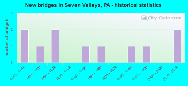
- New bridges - historical statistics
- 21910-1919
- 11920-1929
- 21930-1939
- 11950-1959
- 11960-1969
- 11980-1989
- 11990-1999
- 22010-2019

- Reconstructed bridges - Historical Statistics
- 11960-1969
- 11970-1979
- 01980-1989
- 11990-1999


- Bridge Condition - Deck
- 11.1%Very good
- 33.3%Good
- 33.3%Satisfactory
- 22.2%Fair

- Bridge Condition - Superstructure
- 18.2%Very good
- 9.1%Good
- 45.5%Satisfactory
- 18.2%Fair
- 9.1%Poor

- Bridge Condition - Substructure
- 18.2%Very good
- 18.2%Good
- 36.4%Satisfactory
- 18.2%Fair
- 9.1%Poor

- Bridge Condition - Channel
- 9.1%Good
- 63.6%Satisfactory
- 27.3%Fair
Find on map >> Show street view
Structure Number: 5571, Location: 0.5MI.S.OF EAST FREEDOM (Lat: 40.343517, Lng: -78.432469), Route carried "on" structure: Interstate 99, Year Built: 1986, Year Reconstructed: 2004, Status: Open, Structure Length: 23.20m (76.12ft), Average Daily Traffic: 5,576 (year 2021), Truck Traffic: 20%, Average Future Daily Traffic: 7,270 (year 2032), Design Load: HS 25 or greater, Features Intersected: SR 3013,C-101,RR,JUN.RIV
Minimum Vertical Clearance: 30+ m (98+ ft), Kilometerpoint: 9.804, Lanes on structure: 2, Lanes under structure: 4, Base Highway Network: Yes, Owner: State Highway Agency, Approaching Roadway Width: 11.6m (38.1ft), Skew: 14 degrees, Material/Design: Steel continuous, Design/Construction: Stringer/Multi-beam, Number Of Spans In Main Unit: 5, Length of Maximum Span: 51.8m (169.9ft), Curb or Sidewalk Widths: Left: 0.2m (0.7ft), Right: 0.2m (0.7ft), Curb-To-Curb Width: 12.2m (40.0ft), Out-to-Out Width: 13.2m (43.3ft)
Condition: Deck: Good, Superstructure: Good, Substructure: Satisfactory, Channel: Good, Operating Rating: 68.0 metric tons, Method Used To Determine Operating Rating: Load Factor (LF), Inventory Rating: 40.8 metric tons, Method Used To Determine Inventory Rating: Load Factor (LF), Structural Evaluation: Equal to present minimum criteria, Deck Geometry: Better than present minimum criteria, Underclear: Meets minimum limits, Waterway Adequacy: Superior to present desirable criteria, Approach Roadway Alignment: Equal to present desirable criteria, Length Of Structure Improvement: 23.70m (77.76ft), Designated Inspection Frequency: Every 24 months, Inspection Date: October 2020, Deck Structure Type: Concrete Cast-file-Place, Wearing Surface/Protective System: Wearing Surface: Monolithic Concrete, Deck Protection: Epoxy Coated Reinforcing
Find on map >> Show street view
Structure Number: 5704, Location: 3 MI.NE.OF CULP (Lat: 40.598131, Lng: -78.215631), Route carried "on" structure: State highway , Year Built: 1926, Year Reconstructed: 1969, Status: Open, Structure Length: 0.79m (2.59ft), Average Daily Traffic: 482 (year 2022), Truck Traffic: 10%, Average Future Daily Traffic: 743 (year 2032), Design Load: HS 20, Features Intersected: SINKING RUN, Facility Carried by Structure: SR 1013
Minimum Vertical Clearance: 30+ m (98+ ft), Kilometerpoint: 19.121, Lanes on structure: 2, Owner: State Highway Agency, Approaching Roadway Width: 7.6m (24.9ft), Skew: 4 degrees, Material/Design: Concrete, Design/Construction: Slab, Number Of Spans In Main Unit: 1, Length of Maximum Span: 7.0m (23.0ft), Curb or Sidewalk Widths: Left: 0.1m (0.3ft), Right: 0.1m (0.3ft), Curb-To-Curb Width: 6.7m (22.0ft), Out-to-Out Width: 7.4m (24.3ft)
Condition: Deck: Satisfactory, Superstructure: Satisfactory, Substructure: Good, Channel: Satisfactory, Operating Rating: 57.2 metric tons, Method Used To Determine Operating Rating: Load Factor (LF), Inventory Rating: 33.6 metric tons, Method Used To Determine Inventory Rating: Load Factor (LF), Structural Evaluation: Equal to present minimum criteria, Deck Geometry: Meets minimum limits, Waterway Adequacy: Equal to present minimum criteria, Approach Roadway Alignment: Equal to present desirable criteria, Length Of Structure Improvement: 1.40m (4.59ft), Designated Inspection Frequency: Every 24 months, Inspection Date: March 2021, Wearing Surface/Protective System: Wearing Surface: Bituminous
Find on map >> Show street view
Structure Number: 5705, Location: .5 MI.SW.OF ARCH SPRING (Lat: 40.605928, Lng: -78.203450), Route carried "on" structure: State highway , Year Built: 1931, Status: Open, Structure Length: 2.74m (8.99ft), Average Daily Traffic: 482 (year 2022), Truck Traffic: 10%, Average Future Daily Traffic: 743 (year 2032), Design Load: HS 15, Features Intersected: SINKING RUN, Facility Carried by Structure: SR 1013
Minimum Vertical Clearance: 30+ m (98+ ft), Kilometerpoint: 20.318, Lanes on structure: 2, Owner: State Highway Agency, Approaching Roadway Width: 7.3m (24.0ft), Skew: 4 degrees, Material/Design: Concrete, Design/Construction: Tee Beam, Number Of Spans In Main Unit: 2, Length of Maximum Span: 12.8m (42.0ft), Curb-To-Curb Width: 9.1m (29.9ft), Out-to-Out Width: 10.0m (32.8ft)
Condition: Deck: Fair, Superstructure: Satisfactory, Substructure: Fair, Channel: Fair, Operating Rating: 34.5 metric tons, Method Used To Determine Operating Rating: Load Factor (LF), Inventory Rating: 20.9 metric tons, Method Used To Determine Inventory Rating: Load Factor (LF), Structural Evaluation: Somewhat better than minimum adequacy, Deck Geometry: Equal to present minimum criteria, Waterway Adequacy: Equal to present minimum criteria, Approach Roadway Alignment: Equal to present desirable criteria, Length Of Structure Improvement: 3.40m (11.15ft), Designated Inspection Frequency: Every 24 months, Inspection Date: March 2021, Bridge Improvement Cost: $85,000, Roadway Improvement Cost: $264,000, Total Project Cost: $1,145,000, Deck Structure Type: Concrete Cast-file-Place, Wearing Surface/Protective System: Wearing Surface: Bituminous
Find on map >> Show street view
Structure Number: 37525, Location: SEVEN VALLEYS BORO (Lat: 39.862047, Lng: -76.757947), Route carried "on" structure: State highway 214, Year Built: 1938, Year Reconstructed: 1982, Status: Open, Structure Length: 1.19m (3.90ft), Average Daily Traffic: 1,747 (year 2022), Truck Traffic: 7%, Average Future Daily Traffic: 2,208 (year 2032), Design Load: HS 20, Features Intersected: FISHEL CREEK
Minimum Vertical Clearance: 30+ m (98+ ft), Kilometerpoint: 1.957, Lanes on structure: 2, Owner: State Highway Agency, Approaching Roadway Width: 8.5m (27.9ft), Material/Design: Steel, Design/Construction: Stringer/Multi-beam, Number Of Spans In Main Unit: 1, Length of Maximum Span: 11.6m (38.1ft), Curb-To-Curb Width: 8.5m (27.9ft), Out-to-Out Width: 9.6m (31.5ft)
Condition: Deck: Satisfactory, Superstructure: Satisfactory, Substructure: Satisfactory, Channel: Satisfactory, Operating Rating: 89.8 metric tons, Method Used To Determine Operating Rating: Load Factor (LF), Inventory Rating: 59.0 metric tons, Method Used To Determine Inventory Rating: Load Factor (LF), Structural Evaluation: Equal to present minimum criteria, Deck Geometry: Somewhat better than minimum adequacy, Waterway Adequacy: Equal to present minimum criteria, Approach Roadway Alignment: Better than present minimum criteria, Length Of Structure Improvement: 1.80m (5.91ft), Designated Inspection Frequency: Every 48 months, Inspection Date: August 2019, Deck Structure Type: Concrete Cast-file-Place, Wearing Surface/Protective System: Wearing Surface: Monolithic Concrete, Deck Protection: Epoxy Coated Reinforcing
Find on map >> Show street view
Structure Number: 37842, Location: 1 MI.S. SEITZVILLE (Lat: 39.819614, Lng: -76.760369), Route carried "on" structure: State highway , Year Built: 1960, Status: Open, Structure Length: 1.95m (6.40ft), Average Daily Traffic: 363 (year 2021), Truck Traffic: 19%, Average Future Daily Traffic: 298 (year 2032), Design Load: HS 20, Features Intersected: S BR CODORUS CREEK, Facility Carried by Structure: SR 3016
Minimum Vertical Clearance: 30+ m (98+ ft), Kilometerpoint: 0.000, Lanes on structure: 2, Owner: State Highway Agency, Approaching Roadway Width: 7.6m (24.9ft), Material/Design: Prestressed concrete, Design/Construction: Box Beam or Girders - Multiple, Number Of Spans In Main Unit: 1, Length of Maximum Span: 18.3m (60.0ft), Curb or Sidewalk Widths: Left: 0.5m (1.6ft), Right: 0.5m (1.6ft), Curb-To-Curb Width: 8.6m (28.2ft), Out-to-Out Width: 10.1m (33.1ft)
Condition: Deck: Fair, Superstructure: Fair, Substructure: Fair, Channel: Satisfactory, Operating Rating: 58.1 metric tons, Method Used To Determine Operating Rating: Load Factor (LF), Inventory Rating: 17.2 metric tons, Method Used To Determine Inventory Rating: Load Factor (LF), Structural Evaluation: Somewhat better than minimum adequacy, Deck Geometry: Equal to present minimum criteria, Waterway Adequacy: Better than present minimum criteria, Approach Roadway Alignment: Equal to present desirable criteria, Length Of Structure Improvement: 2.70m (8.86ft), Designated Inspection Frequency: Every 24 months, Inspection Date: August 2021, Deck Structure Type: Other, Wearing Surface/Protective System: Wearing Surface: Bituminous
Find on map >> Show street view
Structure Number: 37846, Location: 3 MILE NW OF LOGANVILLE (Lat: 39.874442, Lng: -76.749261), Route carried "on" structure: State highway , Year Built: 1993, Status: Open, Structure Length: 2.32m (7.61ft), Average Daily Traffic: 705 (year 2022), Truck Traffic: 6%, Average Future Daily Traffic: 858 (year 2032), Design Load: HS 25 or greater, Features Intersected: SOUTH BR CODORUS CREEK, Facility Carried by Structure: GLADFELTER STATION
Minimum Vertical Clearance: 30+ m (98+ ft), Kilometerpoint: 4.326, Lanes on structure: 2, Owner: State Highway Agency, Approaching Roadway Width: 7.3m (24.0ft), Skew: 1 degrees, Material/Design: Prestressed concrete, Design/Construction: Box Beam or Girders - Multiple, Number Of Spans In Main Unit: 1, Length of Maximum Span: 22.9m (75.1ft), Curb or Sidewalk Widths: Left: 0.2m (0.7ft), Right: 0.2m (0.7ft), Curb-To-Curb Width: 7.6m (24.9ft), Out-to-Out Width: 8.6m (28.2ft)
Condition: Deck: Satisfactory, Superstructure: Satisfactory, Substructure: Good, Channel: Satisfactory, Operating Rating: 89.8 metric tons, Method Used To Determine Operating Rating: Load Factor (LF), Inventory Rating: 48.1 metric tons, Method Used To Determine Inventory Rating: Load Factor (LF), Structural Evaluation: Equal to present minimum criteria, Deck Geometry: Meets minimum limits, Waterway Adequacy: Equal to present minimum criteria, Approach Roadway Alignment: Equal to present minimum criteria, Length Of Structure Improvement: 3.00m (9.84ft), Designated Inspection Frequency: Every 48 months, Inspection Date: August 2019, Deck Structure Type: Concrete Cast-file-Place, Wearing Surface/Protective System: Wearing Surface: Monolithic Concrete, Deck Protection: Epoxy Coated Reinforcing
Find on map >> Show street view
Structure Number: 38084, Location: @ SEITZVILLE/S.BR.CODORUS (Lat: 39.829436, Lng: -76.761214), Route carried "on" structure: City street , Year Built: 1910, Status: Open, Structure Length: 1.28m (4.20ft), Average Daily Traffic: 141 (year 2011), Truck Traffic: 5%, Average Future Daily Traffic: 200 (year 2021), Features Intersected: SO BRANCH CODORUS CREEK, Facility Carried by Structure: SEITZVILLE ROAD
Minimum Vertical Clearance: 30+ m (98+ ft), Kilometerpoint: 0.000, Lanes on structure: 1, Owner: County Highway Agency, Approaching Roadway Width: 4.9m (16.1ft), Material/Design: Concrete, Design/Construction: Arch - Deck, Number Of Spans In Main Unit: 1, Length of Maximum Span: 12.2m (40.0ft), Curb-To-Curb Width: 4.1m (13.5ft), Out-to-Out Width: 5.1m (16.7ft)
Condition: Superstructure: Satisfactory, Substructure: Satisfactory, Channel: Fair, Operating Rating: 49.0 metric tons, Method Used To Determine Operating Rating: Field evaluation and documented engineering judgment, Inventory Rating: 32.7 metric tons, Method Used To Determine Inventory Rating: Field evaluation and documented engineering judgment, Structural Evaluation: Equal to present minimum criteria, Deck Geometry: High priority of replacement, Waterway Adequacy: Equal to present minimum criteria, Approach Roadway Alignment: Equal to present desirable criteria, Length Of Structure Improvement: 1.90m (6.23ft), Designated Inspection Frequency: Every 24 months, Inspection Date: July 2021, Bridge Improvement Cost: $5,000, Roadway Improvement Cost: $14,000, Total Project Cost: $64,000, Wearing Surface/Protective System: Wearing Surface: Bituminous
Find on map >> Show street view
Structure Number: 38085, Location: S.BR.CODORUS/@ SEITZVILLE (Lat: 39.825742, Lng: -76.764117), Route carried "on" structure: City street , Year Built: 1916, Status: Open, Structure Length: 2.26m (7.41ft), Average Daily Traffic: 34 (year 2011), Truck Traffic: 2%, Average Future Daily Traffic: 420 (year 2031), Features Intersected: SO BRANCH CODORUS CREEK, Facility Carried by Structure: GRAINERY ROAD
Minimum Vertical Clearance: 30+ m (98+ ft), Kilometerpoint: 0.000, Lanes on structure: 1, Owner: County Highway Agency, Approaching Roadway Width: 4.9m (16.1ft), Material/Design: Concrete, Design/Construction: Arch - Deck, Number Of Spans In Main Unit: 1, Length of Maximum Span: 21.9m (71.9ft), Curb-To-Curb Width: 4.7m (15.4ft), Out-to-Out Width: 5.4m (17.7ft)
Condition: Superstructure: Fair, Substructure: Satisfactory, Channel: Satisfactory, Operating Rating: 49.0 metric tons, Method Used To Determine Operating Rating: Field evaluation and documented engineering judgment, Inventory Rating: 32.7 metric tons, Method Used To Determine Inventory Rating: Field evaluation and documented engineering judgment, Structural Evaluation: Somewhat better than minimum adequacy, Deck Geometry: Better than present minimum criteria, Waterway Adequacy: Equal to present minimum criteria, Approach Roadway Alignment: Equal to present desirable criteria, Length Of Structure Improvement: 3.00m (9.84ft), Designated Inspection Frequency: Every 24 months, Inspection Date: August 2021
Find on map >> Show street view
Structure Number: 38087, Location: 0.25S 7VALLEYS/S.BR.CODOR (Lat: 39.844172, Lng: -76.774825), Route carried "on" structure: City street , Year Built: 1955, Status: Posted for load, Structure Length: 1.52m (4.99ft), Average Daily Traffic: 236 (year 2011), Truck Traffic: 5%, Average Future Daily Traffic: 896 (year 2032), Design Load: HS 20, Features Intersected: SOUTH BR CODORUS CREEK, Facility Carried by Structure: T536; MAPLE STREET
Minimum Vertical Clearance: 30+ m (98+ ft), Kilometerpoint: 0.000, Lanes on structure: 1, Owner: County Highway Agency, Approaching Roadway Width: 4.6m (15.1ft), Material/Design: Prestressed concrete, Design/Construction: Slab, Number Of Spans In Main Unit: 2, Length of Maximum Span: 7.3m (24.0ft), Curb-To-Curb Width: 5.1m (16.7ft), Out-to-Out Width: 5.5m (18.0ft)
Condition: Deck: Good, Superstructure: Poor, Substructure: Poor, Channel: Fair, Operating Rating: 42.6 metric tons, Method Used To Determine Operating Rating: Load Factor (LF), Inventory Rating: 25.4 metric tons, Method Used To Determine Inventory Rating: Load Factor (LF), Structural Evaluation: Meets minimum limits, Deck Geometry: High priority of replacement, Waterway Adequacy: Equal to present minimum criteria, Approach Roadway Alignment: Equal to present minimum criteria, Bridge Posting: Required (Relationship of Operating Rating to Maximum Legal Load: 10.0 - 19.9% below), Length Of Structure Improvement: 2.20m (7.22ft), Designated Inspection Frequency: Every 24 months, Other Special Inspection Frequency: Every 12 months, Inspection Date: August 2021, Other Special Inspection Date: August 2021, Bridge Improvement Cost: $6,000, Roadway Improvement Cost: $19,000, Total Project Cost: $86,000, Deck Structure Type: Concrete Cast-file-Place, Wearing Surface/Protective System: Wearing Surface: Monolithic Concrete
Find on map >> Show street view
Structure Number: 47742, Location: SEVEN VALLEYS BORO (Lat: 39.855472, Lng: -76.773750), Route carried "on" structure: State highway 214, Year Built: 2012, Status: Open, Structure Length: 3.69m (12.11ft), Average Daily Traffic: 5,101 (year 2021), Truck Traffic: 5%, Average Future Daily Traffic: 5,218 (year 2032), Design Load: HL 93, Features Intersected: S BR OF CODORUS CREEK
Minimum Vertical Clearance: 30+ m (98+ ft), Kilometerpoint: 0.000, Lanes on structure: 2, Owner: State Highway Agency, Approaching Roadway Width: 10.7m (35.1ft), Skew: 3 degrees, Material/Design: Concrete, Design/Construction: Box Beam or Girders - Single/Spread, Number Of Spans In Main Unit: 2, Length of Maximum Span: 18.0m (59.1ft), Curb-To-Curb Width: 10.5m (34.4ft), Out-to-Out Width: 11.4m (37.4ft)
Condition: Deck: Good, Superstructure: Very good, Substructure: Very good, Channel: Satisfactory, Operating Rating: 58.3 metric tons, Method Used To Determine Operating Rating: Assigned ratings based on Load and Resistance Factor Design (LRFD) reported by rating factor (RF) using HL93 loadings, Inventory Rating: 36.6 metric tons, Method Used To Determine Inventory Rating: Assigned ratings based on Load and Resistance Factor Design (LRFD) reported by rating factor (RF) using HL93 loadings, Structural Evaluation: Equal to present desirable criteria, Deck Geometry: Meets minimum limits, Waterway Adequacy: Better than present minimum criteria, Approach Roadway Alignment: Equal to present desirable criteria, Designated Inspection Frequency: Every 48 months, Inspection Date: August 2021, Deck Structure Type: Concrete Cast-file-Place, Wearing Surface/Protective System: Wearing Surface: Monolithic Concrete, Deck Protection: Epoxy Coated Reinforcing
Find on map >> Show street view
Structure Number: 54709, Location: SEVEN VALLEYS (Lat: 39.848806, Lng: -76.781000), Route carried "on" structure: State highway 616, Year Built: 2017, Status: Open, Structure Length: 1.28m (4.20ft), Average Daily Traffic: 1,338 (year 2021), Truck Traffic: 11%, Average Future Daily Traffic: 3,348 (year 2032), Design Load: HL 93, Features Intersected: TRIB TO S BR CODORUS CR
Minimum Vertical Clearance: 30+ m (98+ ft), Kilometerpoint: 12.175, Lanes on structure: 2, Owner: State Highway Agency, Approaching Roadway Width: 7.6m (24.9ft), Material/Design: Prestressed concrete, Design/Construction: Box Beam or Girders - Single/Spread, Number Of Spans In Main Unit: 1, Length of Maximum Span: 12.2m (40.0ft), Curb-To-Curb Width: 9.8m (32.2ft), Out-to-Out Width: 10.4m (34.1ft)
Condition: Deck: Very good, Superstructure: Very good, Substructure: Very good, Channel: Satisfactory, Operating Rating: 45.7 metric tons, Method Used To Determine Operating Rating: Assigned ratings based on Load and Resistance Factor Design (LRFD) reported by rating factor (RF) using HL93 loadings, Inventory Rating: 35.3 metric tons, Method Used To Determine Inventory Rating: Assigned ratings based on Load and Resistance Factor Design (LRFD) reported by rating factor (RF) using HL93 loadings, Structural Evaluation: Equal to present desirable criteria, Deck Geometry: Somewhat better than minimum adequacy, Waterway Adequacy: Equal to present desirable criteria, Approach Roadway Alignment: Equal to present minimum criteria, Designated Inspection Frequency: Every 48 months, Inspection Date: August 2021, Deck Structure Type: Concrete Cast-file-Place, Wearing Surface/Protective System: Wearing Surface: Monolithic Concrete, Deck Protection: Epoxy Coated Reinforcing