Bridge Statistics for Seminole, Florida (FL)
Condition, Traffic, Stress, Structural Evaluation, Project Costs
- National Bridge Inventory (NBI) Statistics
- 14Number of bridges
- 184ft / 55.8mTotal length
- 267,101Total average daily traffic
- 8,910Total average daily truck traffic
- National Bridge Inventory (NBI) Registered Bridges for Seminole
- No street view available for this location
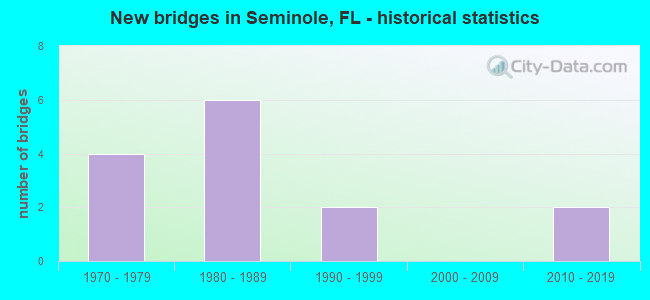
- New bridges - historical statistics
- 41970-1979
- 61980-1989
- 21990-1999
- 22010-2019
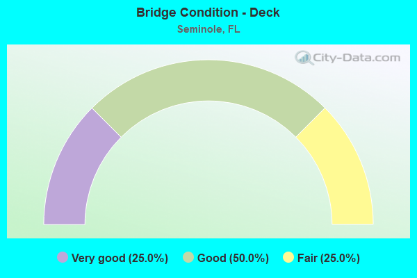
- Bridge Condition - Deck
- 25.0%Very good
- 50.0%Good
- 25.0%Fair
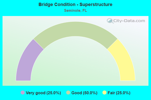
- Bridge Condition - Superstructure
- 25.0%Very good
- 50.0%Good
- 25.0%Fair
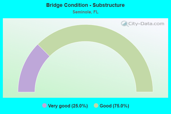
- Bridge Condition - Substructure
- 25.0%Very good
- 75.0%Good
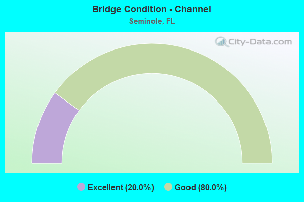
- Bridge Condition - Channel
- 20.0%Excellent
- 80.0%Good
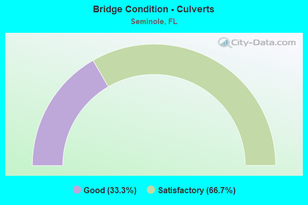
- Bridge Condition - Culverts
- 33.3%Good
- 66.7%Satisfactory
Find on map >> Show street view
Structure Number: 150063, Location: 0.5 MI EAST OF ALT 19 (Lat: 27.839325, Lng: -82.779950), Route carried "on" structure: County highway 694, Year Built: 1976, Status: Open, Structure Length: 1.17m (3.84ft), Average Daily Traffic: 49,500 (year 2020), Truck Traffic: 3%, Average Future Daily Traffic: 85,883 (year 2042), Design Load: HS 20, Features Intersected: LAKE SEMINOLE, Facility Carried by Structure: PARK BLVD
Minimum Vertical Clearance: 30+ m (98+ ft), Kilometerpoint: 9.368, Lanes on structure: 7, Base Highway Network: Yes, Owner: County Highway Agency, Approaching Roadway Width: 26.8m (87.9ft), Skew: 20 degrees, Material/Design: Concrete, Design/Construction: Culvert, Number Of Spans In Main Unit: 3, Length of Maximum Span: 3.9m (12.8ft), Curb or Sidewalk Widths: Left: 1.5m (4.9ft), Right: 1.5m (4.9ft)
Condition: Channel: Good, Culverts: Satisfactory, Operating Rating: 81.6 metric tons, Method Used To Determine Operating Rating: Load Factor (LF), Inventory Rating: 49.0 metric tons, Method Used To Determine Inventory Rating: Load Factor (LF), Structural Evaluation: Equal to present minimum criteria, Waterway Adequacy: Equal to present desirable criteria, Approach Roadway Alignment: Equal to present desirable criteria, Designated Inspection Frequency: Every 24 months, Underwater Inspection Frequency: Every 24 months, Inspection Date: November 2021, Underwater Inspection Date: October 2021
Find on map >> Show street view
Structure Number: 15011, Location: 1MI E OF ALT 19 (Lat: 27.839333, Lng: -82.770917), Route carried "on" structure: County highway 694, Year Built: 1975, Status: Open, Structure Length: 1.55m (5.09ft), Average Daily Traffic: 49,500 (year 2020), Truck Traffic: 3%, Average Future Daily Traffic: 85,883 (year 2042), Design Load: HS 20, Features Intersected: LAKE SEMINOLE BYPASS, Facility Carried by Structure: PARK BLVD.
Minimum Vertical Clearance: 30+ m (98+ ft), Kilometerpoint: 10.253, Lanes on structure: 6, Base Highway Network: Yes, Owner: County Highway Agency, Approaching Roadway Width: 21.8m (71.5ft), Skew: 21 degrees, Material/Design: Concrete, Design/Construction: Culvert, Number Of Spans In Main Unit: 4, Length of Maximum Span: 3.7m (12.1ft), Curb or Sidewalk Widths: Left: 1.5m (4.9ft), Right: 1.5m (4.9ft)
Condition: Channel: Good, Culverts: Satisfactory, Inventory Rating: 72.3 metric tons, Method Used To Determine Inventory Rating: Load Factor (LF), Structural Evaluation: Equal to present minimum criteria, Waterway Adequacy: Better than present minimum criteria, Approach Roadway Alignment: Equal to present desirable criteria, Designated Inspection Frequency: Every 24 months, Underwater Inspection Frequency: Every 24 months, Inspection Date: November 2021, Underwater Inspection Date: October 2021
Find on map >> Show street view
Structure Number: 150133, Location: BAY PINES INTERCHANGE (Lat: 27.814617, Lng: -82.785503), Route carried "on" structure: Alternate US 19, Year Built: 1980, Status: Open, Structure Length: 38.55m (126.48ft), Average Daily Traffic: 10,500 (year 2020), Truck Traffic: 2%, Average Future Daily Traffic: 18,218 (year 2042), Design Load: HS 20+Mod, Features Intersected: SR-666
Minimum Vertical Clearance: 30+ m (98+ ft), Kilometerpoint: 0.166, Lanes on structure: 2, Lanes under structure: 8, Base Highway Network: Yes, Owner: State Highway Agency, Approaching Roadway Width: 12.3m (40.4ft), Skew: 9 degrees, Material/Design: Steel continuous, Design/Construction: Stringer/Multi-beam, Number Of Spans In Main Unit: 2, Number Of Approach Spans: 12, Length of Maximum Span: 44.5m (146.0ft), Curb-To-Curb Width: 12.3m (40.4ft), Out-to-Out Width: 13.0m (42.7ft)
Condition: Deck: Good, Superstructure: Good, Substructure: Good, Operating Rating: 74.3 metric tons, Method Used To Determine Operating Rating: Load Factor (LF), Inventory Rating: 44.5 metric tons, Method Used To Determine Inventory Rating: Load Factor (LF), Structural Evaluation: Better than present minimum criteria, Deck Geometry: Better than present minimum criteria, Underclear: Equal to present minimum criteria, Approach Roadway Alignment: Equal to present desirable criteria, Designated Inspection Frequency: Every 24 months, Inspection Date: March 2020, Deck Structure Type: Concrete Cast-file-Place
Find on map >> Show street view
Structure Number: 154353, Location: 0.6MI WEST OF STARKEY RD (Lat: 27.850361, Lng: -82.772778), Route carried "on" structure: County highway , Year Built: 1974, Status: Open, Structure Length: 4.57m (14.99ft), Average Daily Traffic: 2,700 (year 2020), Truck Traffic: 5%, Average Future Daily Traffic: 4,685 (year 2042), Design Load: HS 20, Features Intersected: SEMINOLE BYPASS CANAL, Facility Carried by Structure: 86TH AVENUE NORTH
Minimum Vertical Clearance: 30+ m (98+ ft), Kilometerpoint: 0.163, Lanes on structure: 2, Owner: County Highway Agency, Approaching Roadway Width: 7.3m (24.0ft), Material/Design: Prestressed concrete, Design/Construction: Slab, Number Of Spans In Main Unit: 5, Length of Maximum Span: 9.1m (29.9ft), Curb or Sidewalk Widths: Left: 1.0m (3.3ft), Right: 1.0m (3.3ft), Curb-To-Curb Width: 8.0m (26.2ft), Out-to-Out Width: 11.6m (38.1ft)
Condition: Deck: Fair, Superstructure: Fair, Substructure: Good, Channel: Good, Operating Rating: 68.6 metric tons, Method Used To Determine Operating Rating: Load Factor (LF), Inventory Rating: 41.2 metric tons, Method Used To Determine Inventory Rating: Load Factor (LF), Structural Evaluation: Somewhat better than minimum adequacy, Deck Geometry: High priority of corrective action, Waterway Adequacy: Better than present minimum criteria, Approach Roadway Alignment: Equal to present desirable criteria, Designated Inspection Frequency: Every 24 months, Underwater Inspection Frequency: Every 24 months, Inspection Date: November 2021, Underwater Inspection Date: October 2021, Deck Structure Type: Concrete Precast Panels, Wearing Surface/Protective System: Wearing Surface: Bituminous
Find on map >> Show street view
Structure Number: 154356, Location: 1.7MI. W OF ALT US-19 (Lat: 27.865514, Lng: -82.816092), Route carried "on" structure: County highway , Year Built: 1985, Status: Open, Structure Length: 3.11m (10.20ft), Average Daily Traffic: 5,400 (year 2020), Truck Traffic: 3%, Average Future Daily Traffic: 9,369 (year 2042), Features Intersected: MCKAY CREEK, Facility Carried by Structure: 102ND AVE NORTH
Minimum Vertical Clearance: 30+ m (98+ ft), Kilometerpoint: 4.036, Lanes on structure: 2, Owner: County Highway Agency, Approaching Roadway Width: 8.2m (26.9ft), Material/Design: Prestressed concrete, Design/Construction: Slab, Number Of Spans In Main Unit: 3, Length of Maximum Span: 10.4m (34.1ft), Curb or Sidewalk Widths: Left: 2.5m (8.2ft), Right: 2.5m (8.2ft), Curb-To-Curb Width: 8.2m (26.9ft), Out-to-Out Width: 14.3m (46.9ft)
Condition: Deck: Good, Superstructure: Good, Substructure: Good, Channel: Excellent, Operating Rating: 60.9 metric tons, Method Used To Determine Operating Rating: Load Factor (LF), Inventory Rating: 31.3 metric tons, Method Used To Determine Inventory Rating: Load Factor (LF), Structural Evaluation: Better than present minimum criteria, Deck Geometry: High priority of replacement, Waterway Adequacy: Better than present minimum criteria, Approach Roadway Alignment: Equal to present desirable criteria, Designated Inspection Frequency: Every 24 months, Inspection Date: November 2021, Deck Structure Type: Concrete Precast Panels, Wearing Surface/Protective System: Wearing Surface: Bituminous
Find on map >> Show street view
Structure Number: 154359, Location: 1.2MI N OF 102ND AVE N (Lat: 27.877756, Lng: -82.804178), Route carried "on" structure: Other road , Year Built: 1995, Status: Open, Structure Length: 0.67m (2.20ft), Average Daily Traffic: 101 (year 2021), Truck Traffic: 1%, Average Future Daily Traffic: 174 (year 2042), Design Load: HS 20, Features Intersected: PETE'S DITCH, Facility Carried by Structure: WALSINGHAM PARK RD
Minimum Vertical Clearance: 30+ m (98+ ft), Kilometerpoint: 0.000, Lanes on structure: 2, Owner: County Highway Agency, Approaching Roadway Width: 7.5m (24.6ft), Material/Design: Concrete, Design/Construction: Culvert, Number Of Spans In Main Unit: 2, Length of Maximum Span: 3.1m (10.2ft)
Condition: Channel: Good, Culverts: Good, Operating Rating: 54.5 metric tons, Method Used To Determine Operating Rating: Load Factor (LF), Inventory Rating: 32.7 metric tons, Method Used To Determine Inventory Rating: Load Factor (LF), Structural Evaluation: Better than present minimum criteria, Waterway Adequacy: Equal to present desirable criteria, Approach Roadway Alignment: Equal to present desirable criteria, Designated Inspection Frequency: Every 24 months, Inspection Date: November 2021
Find on map >> Show street view
Structure Number: 770095, Location: NB SR-417 Ramp To I-4 WB (Lat: 28.795669, Lng: -81.349744), Route carried "on" structure: Ramp State highway 417, Year Built: 2011, Status: Open, Structure Length: 6.16m (20.21ft), Average Daily Traffic: 5,400 (year 2020), Truck Traffic: 8%, Average Future Daily Traffic: 9,369 (year 2042), Design Load: HL 93, Features Intersected: Ramp A1E, Facility Carried by Structure: Ramp C1
Minimum Vertical Clearance: 30+ m (98+ ft), Kilometerpoint: 1.024, Lanes on structure: 1, Lanes under structure: 1, Owner: State Highway Agency, Approaching Roadway Width: 10.3m (33.8ft), Skew: 4 degrees, Material/Design: Steel, Design/Construction: Stringer/Multi-beam, Number Of Spans In Main Unit: 1, Length of Maximum Span: 61.0m (200.1ft), Curb-To-Curb Width: 10.3m (33.8ft), Out-to-Out Width: 11.0m (36.1ft)
Condition: Deck: Very good, Superstructure: Very good, Substructure: Very good, Operating Rating: 56.8 metric tons, Method Used To Determine Operating Rating: Load and Resistance Factor (LRFR), Inventory Rating: 36.9 metric tons, Method Used To Determine Inventory Rating: Load and Resistance Factor (LRFR), Structural Evaluation: Equal to present desirable criteria, Deck Geometry: Superior to present desirable criteria, Underclear: Equal to present minimum criteria, Approach Roadway Alignment: Equal to present desirable criteria, Designated Inspection Frequency: Every 24 months, Inspection Date: November 2021, Deck Structure Type: Concrete Cast-file-Place, Wearing Surface/Protective System: Wearing Surface: Monolithic Concrete
Find on map >> Show street view
Structure Number: 150133, Location: BAY PINES INTERCHANGE (Lat: 27.814617, Lng: -82.785503), Route carried "under" structure: Ramp State highway 666, Year Built: 1980, Structure Length: 0. m, Average Daily Traffic: 11,000 (year 2020), Truck Traffic: 6%, Features Intersected: SR-666, Facility Carried by Structure: SB US-19A (SR-595)
Minimum Vertical Clearance: 4.94m (16.21ft), Kilometerpoint: 0.093, Lanes on structure: 2, Lanes under structure: 2, Material/Design: Steel continuous, Design/Construction: Stringer/Multi-beam, Length of Maximum Span: 44.5m (146.0ft)
Find on map >> Show street view
Structure Number: 150133, Location: BAY PINES INTERCHANGE (Lat: 27.814617, Lng: -82.785503), Route carried "under" structure: Ramp US 66, Year Built: 1980, Structure Length: 0. m, Average Daily Traffic: 11,000 (year 2020), Truck Traffic: 6%, Features Intersected: SR-666, Facility Carried by Structure: SB US-19A (SR-595)
Minimum Vertical Clearance: 4.79m (15.72ft), Kilometerpoint: 0.240, Lanes on structure: 2, Lanes under structure: 2, Material/Design: Steel continuous, Design/Construction: Stringer/Multi-beam, Length of Maximum Span: 44.5m (146.0ft)
Find on map >> Show street view
Structure Number: 150133, Location: BAY PINES INTERCHANGE (Lat: 27.814617, Lng: -82.785503), Route carried "under" structure: Ramp State highway 666, Year Built: 1980, Structure Length: 0. m, Average Daily Traffic: 25,000 (year 2020), Truck Traffic: 3%, Features Intersected: SR-666, Facility Carried by Structure: SB US-19A (SR-595)
Minimum Vertical Clearance: 4.88m (16.01ft), Kilometerpoint: 14.981, Lanes on structure: 2, Lanes under structure: 4, Material/Design: Steel continuous, Design/Construction: Stringer/Multi-beam, Length of Maximum Span: 44.5m (146.0ft)
Find on map >> Show street view
Structure Number: 159001, Location: 0.4MI WEST OF ALT US-19 (Lat: 27.811250, Lng: -82.790222), Route carried "under" structure: State highway 666, Year Built: 1974, Structure Length: 0. m, Average Daily Traffic: 25,000 (year 2020), Truck Traffic: 3%, Features Intersected: SR-666, Facility Carried by Structure: PEDESTRIAN CROSSWK
Minimum Vertical Clearance: 4.88m (16.01ft), Kilometerpoint: 14.375, Lanes under structure: 8, Material/Design: Steel, Design/Construction: Box Beam or Girders - Single/Spread, Length of Maximum Span: 53.3m (174.9ft)
Find on map >> Show street view
Structure Number: 159005, Location: 0.2MI S OF 54TH AVE N (Lat: 27.817500, Lng: -82.787222), Route carried "under" structure: State highway 595, Year Built: 1980, Structure Length: 0. m, Average Daily Traffic: 35,500 (year 2020), Truck Traffic: 3%, Features Intersected: US19 ALT (SEMINOLE BLVD), Facility Carried by Structure: PEDESTRIAN BRIDGE
Minimum Vertical Clearance: 5.18m (16.99ft), Kilometerpoint: 16.462, Lanes under structure: 7, Material/Design: Steel, Design/Construction: Box Beam or Girders - Single/Spread, Length of Maximum Span: 40.6m (133.2ft)
Find on map >> Show street view
Structure Number: 15901, Location: AT 66TH AVE. NORTH (Lat: 27.817481, Lng: -82.787044), Route carried "under" structure: Alternate US 19, Year Built: 1998, Structure Length: 0. m, Average Daily Traffic: 35,500 (year 2020), Truck Traffic: 3%, Features Intersected: ALT US-19 (SR-595), Facility Carried by Structure: PINELLAS TRAIL
Minimum Vertical Clearance: 5.33m (17.49ft), Kilometerpoint: 18.097, Lanes under structure: 7, Material/Design: Steel, Design/Construction: Box Beam or Girders - Single/Spread, Length of Maximum Span: 52.1m (170.9ft)
Find on map >> Show street view
Structure Number: 770095, Location: NB SR-417 Ramp To I-4 WB (Lat: 28.795669, Lng: -81.349744), Route carried "under" structure: Ramp State highway 417, Year Built: 2011, Structure Length: 0. m, Average Daily Traffic: 1,000 (year 2011), Truck Traffic: 5%, Features Intersected: Ramp A1E, Facility Carried by Structure: Ramp C1
Minimum Vertical Clearance: 5.09m (16.70ft), Kilometerpoint: 0.000, Lanes on structure: 1, Lanes under structure: 1, Material/Design: Steel, Design/Construction: Stringer/Multi-beam, Length of Maximum Span: 61.0m (200.1ft)