Bridge Statistics for Sellersville, Pennsylvania (PA)
Condition, Traffic, Stress, Structural Evaluation, Project Costs
- National Bridge Inventory (NBI) Statistics
- 15Number of bridges
- 85ft / 26.1mTotal length
- $4,504,000Total costs
- 187,865Total average daily traffic
- 16,466Total average daily truck traffic
- National Bridge Inventory (NBI) Registered Bridges for Sellersville
- No street view available for this location
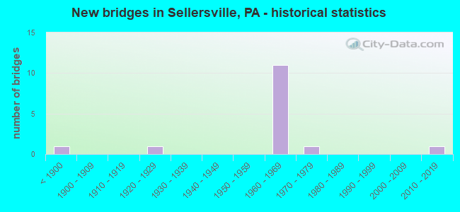
- New bridges - historical statistics
- 1Before 1900
- 11920-1929
- 111960-1969
- 11970-1979
- 12010-2019

- Reconstructed bridges - Historical Statistics
- 11970-1979
- 01980-1989
- 01990-1999
- 12000-2009
- 02010-2019
- 12020-2022


- Bridge Condition - Deck
- 12.5%Very good
- 25.0%Good
- 62.5%Satisfactory

- Bridge Condition - Superstructure
- 12.5%Very good
- 12.5%Good
- 62.5%Satisfactory
- 12.5%Fair

- Bridge Condition - Substructure
- 12.5%Very good
- 12.5%Good
- 62.5%Satisfactory
- 12.5%Fair

- Bridge Condition - Channel
- 25.0%Good
- 25.0%Fair
- 50.0%Poor
Find on map >> Show street view
Structure Number: 691, Location: .7MI.EAST TELFORD 20E06 (Lat: 40.344322, Lng: -75.312514), Route carried "on" structure: State highway 152, Year Built: 1967, Status: Open, Structure Length: 3.72m (12.20ft), Average Daily Traffic: 7,799 (year 2020), Truck Traffic: 12%, Average Future Daily Traffic: 13,546 (year 2032), Design Load: HS 20, Features Intersected: CSX (Leased fromSEPTA ), Facility Carried by Structure: STATE ROAD
Minimum Vertical Clearance: 30+ m (98+ ft), Kilometerpoint: 21.612, Lanes on structure: 4, Owner: State Highway Agency, Approaching Roadway Width: 16.2m (53.1ft), Skew: 21 degrees, Material/Design: Prestressed concrete, Design/Construction: Box Beam or Girders - Multiple, Number Of Spans In Main Unit: 1, Number Of Approach Spans: 2, Length of Maximum Span: 14.3m (46.9ft), Curb or Sidewalk Widths: Left: 0.5m (1.6ft), Right: 0.5m (1.6ft), Curb-To-Curb Width: 20.8m (68.2ft), Out-to-Out Width: 22.4m (73.5ft)
Condition: Deck: Satisfactory, Superstructure: Satisfactory, Substructure: Satisfactory, Operating Rating: 45.4 metric tons, Method Used To Determine Operating Rating: Load Factor (LF), Inventory Rating: 27.2 metric tons, Method Used To Determine Inventory Rating: Load Factor (LF), Structural Evaluation: Equal to present minimum criteria, Deck Geometry: Superior to present desirable criteria, Underclear: High priority of corrective action, Approach Roadway Alignment: Better than present minimum criteria, Length Of Structure Improvement: 4.70m (15.42ft), Designated Inspection Frequency: Every 24 months, Inspection Date: May 2021, Bridge Improvement Cost: $17,000, Roadway Improvement Cost: $49,000, Total Project Cost: $224,000, Deck Structure Type: Concrete Cast-file-Place, Wearing Surface/Protective System: Wearing Surface: Latex Concrete
Find on map >> Show street view
Structure Number: 6911, Location: 1MI E.OF TELFORD 20E06 (Lat: 40.344428, Lng: -75.310733), Route carried "on" structure: State highway 152, Year Built: 1966, Status: Open, Structure Length: 0.91m (2.99ft), Average Daily Traffic: 7,799 (year 2020), Truck Traffic: 12%, Average Future Daily Traffic: 13,546 (year 2032), Design Load: HS 20, Features Intersected: MILL CREEK, Facility Carried by Structure: STATE ROAD
Minimum Vertical Clearance: 30+ m (98+ ft), Kilometerpoint: 20.860, Lanes on structure: 4, Owner: State Highway Agency, Approaching Roadway Width: 15.8m (51.8ft), Material/Design: Concrete, Design/Construction: Culvert, Number Of Spans In Main Unit: 1, Length of Maximum Span: 9.1m (29.9ft)
Condition: Channel: Poor, Culverts: Satisfactory, Operating Rating: 74.4 metric tons, Method Used To Determine Operating Rating: Field evaluation and documented engineering judgment, Inventory Rating: 44.5 metric tons, Method Used To Determine Inventory Rating: Field evaluation and documented engineering judgment, Structural Evaluation: Equal to present minimum criteria, Waterway Adequacy: Superior to present desirable criteria, Approach Roadway Alignment: Equal to present desirable criteria, Length Of Structure Improvement: 1.60m (5.25ft), Designated Inspection Frequency: Every 24 months, Inspection Date: June 2020
Find on map >> Show street view
Structure Number: 6974, Location: 1.2 MI TO LR386 20B04 (Lat: 40.352358, Lng: -75.329550), Route carried "on" structure: State highway 309, Year Built: 1967, Status: Open, Structure Length: 1.49m (4.89ft), Average Daily Traffic: 35,081 (year 2022), Truck Traffic: 9%, Average Future Daily Traffic: 43,982 (year 2032), Design Load: HS 20, Features Intersected: CAT HILL ROAD, Facility Carried by Structure: SELLERSVILLE BYPAS
Minimum Vertical Clearance: 30+ m (98+ ft), Kilometerpoint: 9.764, Lanes on structure: 2, Lanes under structure: 2, Base Highway Network: Yes, Owner: State Highway Agency, Approaching Roadway Width: 26.8m (87.9ft), Skew: 32 degrees, Material/Design: Prestressed concrete, Design/Construction: Box Beam or Girders - Single/Spread, Number Of Spans In Main Unit: 1, Length of Maximum Span: 14.3m (46.9ft), Curb or Sidewalk Widths: Left: 0.2m (0.7ft), Right: 0.2m (0.7ft), Curb-To-Curb Width: 24.4m (80.1ft), Out-to-Out Width: 27.3m (89.6ft)
Condition: Deck: Satisfactory, Superstructure: Satisfactory, Substructure: Satisfactory, Operating Rating: 68.0 metric tons, Method Used To Determine Operating Rating: Load Factor (LF), Inventory Rating: 29.9 metric tons, Method Used To Determine Inventory Rating: Load Factor (LF), Structural Evaluation: Equal to present minimum criteria, Deck Geometry: Superior to present desirable criteria, Underclear: High priority of corrective action, Approach Roadway Alignment: Equal to present desirable criteria, Length Of Structure Improvement: 2.20m (7.22ft), Designated Inspection Frequency: Every 24 months, Inspection Date: June 2021, Bridge Improvement Cost: $28,000, Roadway Improvement Cost: $82,000, Total Project Cost: $376,000, Deck Structure Type: Concrete Cast-file-Place, Wearing Surface/Protective System: Wearing Surface: Latex Concrete
Find on map >> Show street view
Structure Number: 6975, Location: 2MI.S.BETHLEHEM PK.14A12 (Lat: 40.380786, Lng: -75.334489), Route carried "on" structure: State highway 309, Year Built: 1967, Year Reconstructed: 1982, Status: Open, Structure Length: 0.98m (3.22ft), Average Daily Traffic: 36,056 (year 2022), Truck Traffic: 9%, Average Future Daily Traffic: 39,069 (year 2032), Design Load: HS 20, Features Intersected: FORREST ROAD, Facility Carried by Structure: SELLERSVILLE BYPAS
Minimum Vertical Clearance: 30+ m (98+ ft), Kilometerpoint: 13.189, Lanes on structure: 2, Lanes under structure: 2, Base Highway Network: Yes, Owner: State Highway Agency, Approaching Roadway Width: 24.4m (80.1ft), Skew: 31 degrees, Material/Design: Prestressed concrete, Design/Construction: Box Beam or Girders - Single/Spread, Number Of Spans In Main Unit: 1, Length of Maximum Span: 9.8m (32.2ft), Curb or Sidewalk Widths: Left: 0.2m (0.7ft), Right: 0.2m (0.7ft), Curb-To-Curb Width: 24.4m (80.1ft), Out-to-Out Width: 27.3m (89.6ft)
Condition: Deck: Satisfactory, Superstructure: Satisfactory, Substructure: Satisfactory, Operating Rating: 58.1 metric tons, Method Used To Determine Operating Rating: Load Factor (LF), Inventory Rating: 29.9 metric tons, Method Used To Determine Inventory Rating: Load Factor (LF), Structural Evaluation: Equal to present minimum criteria, Deck Geometry: Superior to present desirable criteria, Underclear: Meets minimum limits, Approach Roadway Alignment: Equal to present desirable criteria, Length Of Structure Improvement: 1.70m (5.58ft), Designated Inspection Frequency: Every 24 months, Inspection Date: April 2021, Deck Structure Type: Concrete Cast-file-Place, Wearing Surface/Protective System: Wearing Surface: Latex Concrete
Find on map >> Show street view
Structure Number: 7383, Location: SELLERSVILLE BORO. 20E02 (Lat: 40.362328, Lng: -75.311983), Route carried "on" structure: State highway , Year Built: 1927, Year Reconstructed: 2020, Status: Open, Structure Length: 4.79m (15.72ft), Average Daily Traffic: 9,194 (year 2022), Truck Traffic: 4%, Average Future Daily Traffic: 9,966 (year 2032), Design Load: H 20, Features Intersected: SEPTA (BETHLEHEM BRANCH), Facility Carried by Structure: MAIN STREET
Minimum Vertical Clearance: 30+ m (98+ ft), Kilometerpoint: 7.593, Lanes on structure: 2, Base Highway Network: Yes, Owner: State Highway Agency, Approaching Roadway Width: 9.4m (30.8ft), Skew: 5 degrees, Material/Design: Steel, Design/Construction: Truss - Thru, Number Of Spans In Main Unit: 1, Length of Maximum Span: 41.1m (134.8ft), Curb or Sidewalk Widths: Left: 2.7m (8.9ft), Right: 2.7m (8.9ft), Curb-To-Curb Width: 8.5m (27.9ft), Out-to-Out Width: 14.9m (48.9ft)
Condition: Deck: Very good, Superstructure: Satisfactory, Substructure: Good, Operating Rating: 82.6 metric tons, Method Used To Determine Operating Rating: Load Factor (LF), Inventory Rating: 49.0 metric tons, Method Used To Determine Inventory Rating: Load Factor (LF), Structural Evaluation: Equal to present minimum criteria, Deck Geometry: High priority of replacement, Underclear: High priority of replacement, Approach Roadway Alignment: Somewhat better than minimum adequacy, Length Of Structure Improvement: 5.00m (16.40ft), Designated Inspection Frequency: Every 24 months, Critical Feature Inspection Frequency: Every 24 months, Inspection Date: November 2020, Critical Feature Inspection Date: November 2020, Bridge Improvement Cost: $185,000, Roadway Improvement Cost: $544,000, Total Project Cost: $2,494,000, Deck Structure Type: Concrete Cast-file-Place, Wearing Surface/Protective System: Wearing Surface: Monolithic Concrete, Deck Protection: Epoxy Coated Reinforcing
Find on map >> Show street view
Structure Number: 741, Location: NORTH SELLERSVILLE 20B02 (Lat: 40.366778, Lng: -75.331139), Route carried "on" structure: State highway , Year Built: 1967, Status: Open, Structure Length: 2.77m (9.09ft), Average Daily Traffic: 8,504 (year 2020), Truck Traffic: 8%, Average Future Daily Traffic: 13,586 (year 2032), Design Load: HS 20, Features Intersected: TRAFFIC ROUTE 309, Facility Carried by Structure: LAWN AVENUE
Minimum Vertical Clearance: 30+ m (98+ ft), Kilometerpoint: 1.712, Lanes on structure: 2, Lanes under structure: 4, Owner: State Highway Agency, Approaching Roadway Width: 21.3m (69.9ft), Skew: 21 degrees, Material/Design: Prestressed concrete, Design/Construction: Box Beam or Girders - Single/Spread, Number Of Spans In Main Unit: 1, Length of Maximum Span: 27.4m (89.9ft), Curb or Sidewalk Widths: Left: 0.5m (1.6ft), Right: 0.5m (1.6ft), Curb-To-Curb Width: 20.7m (67.9ft), Out-to-Out Width: 22.4m (73.5ft)
Condition: Deck: Satisfactory, Superstructure: Fair, Substructure: Satisfactory, Operating Rating: 84.4 metric tons, Method Used To Determine Operating Rating: Load Factor (LF), Inventory Rating: 32.7 metric tons, Method Used To Determine Inventory Rating: Load Factor (LF), Structural Evaluation: Somewhat better than minimum adequacy, Deck Geometry: Superior to present desirable criteria, Underclear: High priority of corrective action, Approach Roadway Alignment: Equal to present desirable criteria, Length Of Structure Improvement: 3.70m (12.14ft), Designated Inspection Frequency: Every 24 months, Inspection Date: June 2021, Bridge Improvement Cost: $19,000, Roadway Improvement Cost: $57,000, Total Project Cost: $261,000, Deck Structure Type: Concrete Cast-file-Place, Wearing Surface/Protective System: Wearing Surface: Monolithic Concrete
Find on map >> Show street view
Structure Number: 7477, Location: SELLERSVILLE BORO 20E02 (Lat: 40.362844, Lng: -75.306369), Route carried "on" structure: City street , Year Built: 1978, Status: Open, Structure Length: 0.91m (2.99ft), Average Daily Traffic: 500 (year 2001), Truck Traffic: 3%, Average Future Daily Traffic: 700 (year 2011), Design Load: HS 20, Features Intersected: EAST BR.PERKIOMEN CREEK, Facility Carried by Structure: WALNUT STREET
Minimum Vertical Clearance: 30+ m (98+ ft), Kilometerpoint: 0.000, Lanes on structure: 2, Owner: County Highway Agency, Approaching Roadway Width: 8.2m (26.9ft), Skew: 1 degrees, Material/Design: Prestressed concrete, Design/Construction: Box Beam or Girders - Single/Spread, Number Of Spans In Main Unit: 1, Length of Maximum Span: 8.5m (27.9ft), Curb or Sidewalk Widths: Left: 1.7m (5.6ft), Right: 0.2m (0.7ft), Curb-To-Curb Width: 8.3m (27.2ft), Out-to-Out Width: 11.1m (36.4ft)
Condition: Deck: Satisfactory, Superstructure: Good, Substructure: Satisfactory, Channel: Fair, Operating Rating: 59.0 metric tons, Method Used To Determine Operating Rating: Load Factor (LF), Inventory Rating: 35.4 metric tons, Method Used To Determine Inventory Rating: Load Factor (LF), Structural Evaluation: Equal to present minimum criteria, Deck Geometry: Somewhat better than minimum adequacy, Waterway Adequacy: Equal to present minimum criteria, Approach Roadway Alignment: Equal to present desirable criteria, Length Of Structure Improvement: 1.60m (5.25ft), Designated Inspection Frequency: Every 24 months, Inspection Date: May 2020, Deck Structure Type: Concrete Cast-file-Place, Wearing Surface/Protective System: Wearing Surface: Monolithic Concrete
Find on map >> Show street view
Structure Number: 7562, Location: 0.8 MI N SR 152 2919-K4 (Lat: 40.351397, Lng: -75.313000), Route carried "on" structure: City street , Year Built: 1875, Year Reconstructed: 2011, Status: Posted for load, Structure Length: 5.76m (18.90ft), Average Daily Traffic: 201 (year 1998), Truck Traffic: 3%, Average Future Daily Traffic: 210 (year 2011), Features Intersected: MILL CREEK, Facility Carried by Structure: CLYMER AVENUE
Minimum Vertical Clearance: 30+ m (98+ ft), Kilometerpoint: 0.000, Lanes on structure: 2, Owner: County Highway Agency, Approaching Roadway Width: 5.8m (19.0ft), Material/Design: Masonry, Design/Construction: Arch - Deck, Number Of Spans In Main Unit: 3, Length of Maximum Span: 4.6m (15.1ft), Curb-To-Curb Width: 5.9m (19.4ft), Out-to-Out Width: 7.0m (23.0ft)
Condition: Deck: Good, Superstructure: Satisfactory, Substructure: Fair, Channel: Poor, Operating Rating: 54.4 metric tons, Method Used To Determine Operating Rating: Field evaluation and documented engineering judgment, Inventory Rating: 32.7 metric tons, Method Used To Determine Inventory Rating: Field evaluation and documented engineering judgment, Structural Evaluation: Somewhat better than minimum adequacy, Deck Geometry: High priority of corrective action, Waterway Adequacy: Equal to present minimum criteria, Approach Roadway Alignment: Better than present minimum criteria, Length Of Structure Improvement: 4.50m (14.76ft), Designated Inspection Frequency: Every 24 months, Other Special Inspection Frequency: Every 12 months, Inspection Date: April 2020, Other Special Inspection Date: April 2021, Bridge Improvement Cost: $85,000, Roadway Improvement Cost: $251,000, Total Project Cost: $1,149,000, Deck Structure Type: Concrete Cast-file-Place
Find on map >> Show street view
Structure Number: 56865, Location: SELLERSVILLE BORO 20E03 (Lat: 40.357672, Lng: -75.307694), Route carried "on" structure: State highway , Year Built: 2019, Status: Open, Structure Length: 4.72m (15.49ft), Average Daily Traffic: 6,974 (year 2020), Truck Traffic: 5%, Average Future Daily Traffic: 16,803 (year 2032), Design Load: HL 93, Features Intersected: EAST BR. PERKIOMEN CREEK, Facility Carried by Structure: BETHLEHEM PIKE
Minimum Vertical Clearance: 30+ m (98+ ft), Kilometerpoint: 7.166, Lanes on structure: 3, Base Highway Network: Yes, Owner: State Highway Agency, Approaching Roadway Width: 11.6m (38.1ft), Skew: 2 degrees, Material/Design: Prestressed concrete continuous, Design/Construction: Stringer/Multi-beam, Number Of Spans In Main Unit: 2, Length of Maximum Span: 23.2m (76.1ft), Curb or Sidewalk Widths: Left: 2.4m (7.9ft), Right: 2.4m (7.9ft), Curb-To-Curb Width: 11.6m (38.1ft), Out-to-Out Width: 17.3m (56.8ft)
Condition: Deck: Good, Superstructure: Very good, Substructure: Very good, Channel: Good, Operating Rating: 47.3 metric tons, Method Used To Determine Operating Rating: Assigned ratings based on Load and Resistance Factor Design (LRFD) reported by rating factor (RF) using HL93 loadings, Inventory Rating: 36.3 metric tons, Method Used To Determine Inventory Rating: Assigned ratings based on Load and Resistance Factor Design (LRFD) reported by rating factor (RF) using HL93 loadings, Structural Evaluation: Equal to present desirable criteria, Deck Geometry: High priority of replacement, Waterway Adequacy: Better than present minimum criteria, Approach Roadway Alignment: Equal to present desirable criteria, Designated Inspection Frequency: Every 24 months, Inspection Date: June 2021, Deck Structure Type: Concrete Cast-file-Place, Wearing Surface/Protective System: Wearing Surface: Monolithic Concrete, Deck Protection: Epoxy Coated Reinforcing
Find on map >> Show street view
Structure Number: 6974, Location: 1.2 MI TO LR386 20B04 (Lat: 40.352358, Lng: -75.329550), Route carried "under" structure: State highway , Year Built: 1967, Structure Length: 0. m, Average Daily Traffic: 1,833 (year 2022), Truck Traffic: 5%, Features Intersected: CAT HILL ROAD, Facility Carried by Structure: SELLERSVILLE BYPAS
Minimum Vertical Clearance: 4.22m (13.85ft), Kilometerpoint: 2.511, Lanes on structure: 2, Lanes under structure: 2, Material/Design: Prestressed concrete, Design/Construction: Box Beam or Girders - Single/Spread, Length of Maximum Span: 14.3m (46.9ft)
Find on map >> Show street view
Structure Number: 6975, Location: 2MI.S.BETHLEHEM PK.14A12 (Lat: 40.380786, Lng: -75.334489), Route carried "under" structure: State highway , Year Built: 1967, Structure Length: 0. m, Average Daily Traffic: 1,812 (year 1997), Truck Traffic: 9%, Features Intersected: FORREST ROAD, Facility Carried by Structure: SELLERSVILLE BYPAS
Minimum Vertical Clearance: 4.40m (14.44ft), Kilometerpoint: 0.000, Lanes on structure: 2, Lanes under structure: 2, Material/Design: Prestressed concrete, Design/Construction: Box Beam or Girders - Single/Spread, Length of Maximum Span: 9.8m (32.2ft)
Find on map >> Show street view
Structure Number: 7053, Location: NORTH SELLERSVILLE 20B01 (Lat: 40.369733, Lng: -75.330042), Route carried "under" structure: State highway 309, Year Built: 1967, Structure Length: 0. m, Average Daily Traffic: 18,947 (year 2022), Truck Traffic: 10%, Features Intersected: TRAFFIC ROUTE 309, Facility Carried by Structure: RIDGE ROAD
Minimum Vertical Clearance: 4.50m (14.76ft), Kilometerpoint: 11.782, Lanes on structure: 2, Lanes under structure: 3, Material/Design: Prestressed concrete, Design/Construction: Box Beam or Girders - Single/Spread, Length of Maximum Span: 22.6m (74.1ft)
Find on map >> Show street view
Structure Number: 7053, Location: NORTH SELLERSVILLE 20B01 (Lat: 40.369733, Lng: -75.330042), Route carried "under" structure: State highway 309, Year Built: 1967, Structure Length: 0. m, Average Daily Traffic: 17,109 (year 2022), Truck Traffic: 8%, Features Intersected: TRAFFIC ROUTE 309, Facility Carried by Structure: RIDGE ROAD
Minimum Vertical Clearance: 4.47m (14.67ft), Kilometerpoint: 11.768, Lanes on structure: 2, Lanes under structure: 2, Material/Design: Prestressed concrete, Design/Construction: Box Beam or Girders - Single/Spread, Length of Maximum Span: 22.6m (74.1ft)
Find on map >> Show street view
Structure Number: 741, Location: NORTH SELLERSVILLE 20B02 (Lat: 40.366778, Lng: -75.331139), Route carried "under" structure: State highway 309, Year Built: 1967, Structure Length: 0. m, Average Daily Traffic: 18,947 (year 2022), Truck Traffic: 10%, Features Intersected: TRAFFIC ROUTE 309, Facility Carried by Structure: LAWN AVENUE
Minimum Vertical Clearance: 4.52m (14.83ft), Kilometerpoint: 10.791, Lanes on structure: 2, Lanes under structure: 2, Material/Design: Prestressed concrete, Design/Construction: Box Beam or Girders - Single/Spread, Length of Maximum Span: 27.4m (89.9ft)
Find on map >> Show street view
Structure Number: 741, Location: NORTH SELLERSVILLE 20B02 (Lat: 40.366778, Lng: -75.331139), Route carried "under" structure: State highway 309, Year Built: 1967, Structure Length: 0. m, Average Daily Traffic: 17,109 (year 2022), Truck Traffic: 8%, Features Intersected: TRAFFIC ROUTE 309, Facility Carried by Structure: LAWN AVENUE
Minimum Vertical Clearance: 4.47m (14.67ft), Kilometerpoint: 10.783, Lanes on structure: 2, Lanes under structure: 2, Material/Design: Prestressed concrete, Design/Construction: Box Beam or Girders - Single/Spread, Length of Maximum Span: 27.4m (89.9ft)