Bridge Statistics for Seibert, Colorado (CO)
Condition, Traffic, Stress, Structural Evaluation, Project Costs
- National Bridge Inventory (NBI) Statistics
- 11Number of bridges
- 177ft / 53.6mTotal length
- 61,610Total average daily traffic
- 11,300Total average daily truck traffic
- National Bridge Inventory (NBI) Registered Bridges for Seibert
- No street view available for this location
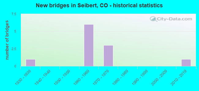
- New bridges - historical statistics
- 11930-1939
- 61960-1969
- 31970-1979
- 12010-2019


- Bridge Condition - Deck
- 12.5%Very good
- 62.5%Good
- 25.0%Fair

- Bridge Condition - Superstructure
- 50.0%Good
- 25.0%Satisfactory
- 25.0%Fair

- Bridge Condition - Substructure
- 12.5%Very good
- 37.5%Good
- 37.5%Satisfactory
- 12.5%Fair

- Bridge Condition - Channel
- 83.3%Very good
- 16.7%Good
Find on map >> Show street view
Structure Number: G-25-B, Location: 14.5 MI E OF FLAGLER (Lat: 39.294117, Lng: -102.817586), Route carried "on" structure: County highway , Year Built: 1964, Status: Open, Structure Length: 7.53m (24.70ft), Average Daily Traffic: 10,000 (year 2018), Average Future Daily Traffic: 32 (year 2034), Design Load: HS 20, Features Intersected: I 70 ML, Facility Carried by Structure: COUNTY ROAD 19
Minimum Vertical Clearance: 30+ m (98+ ft), Kilometerpoint: 18.413, Lanes on structure: 2, Lanes under structure: 4, Owner: State Highway Agency, Approaching Roadway Width: 7.3m (24.0ft), Material/Design: Concrete continuous, Design/Construction: Tee Beam, Number Of Spans In Main Unit: 5, Length of Maximum Span: 17.4m (57.1ft), Curb or Sidewalk Widths: Left: 0.6m (2.0ft), Right: 0.6m (2.0ft), Curb-To-Curb Width: 7.3m (24.0ft), Out-to-Out Width: 8.5m (27.9ft)
Condition: Deck: Good, Superstructure: Good, Substructure: Good, Operating Rating: 37.2 metric tons, Method Used To Determine Operating Rating: Load Factor (LF), Inventory Rating: 21.8 metric tons, Method Used To Determine Inventory Rating: Load Factor (LF), Structural Evaluation: Somewhat better than minimum adequacy, Deck Geometry: High priority of replacement, Underclear: Equal to present minimum criteria, Approach Roadway Alignment: Equal to present desirable criteria, Designated Inspection Frequency: Every 24 months, Inspection Date: September 2021, Deck Structure Type: Other, Wearing Surface/Protective System: Wearing Surface: Monolithic Concrete
Find on map >> Show street view
Structure Number: G-25-C, Location: 4.2 MI N OF SEIBERT (Lat: 39.353281, Lng: -102.873333), Route carried "on" structure: State highway 59A, Year Built: 1969, Status: Open, Structure Length: 5.79m (19.00ft), Average Daily Traffic: 640 (year 2020), Truck Traffic: 27%, Average Future Daily Traffic: 762 (year 2040), Design Load: HS 20+Mod, Features Intersected: S FK REPUBLICAN RIVER, Facility Carried by Structure: SH 59 ML
Minimum Vertical Clearance: 30+ m (98+ ft), Kilometerpoint: 71.588, Lanes on structure: 2, Base Highway Network: Yes, Owner: State Highway Agency, Approaching Roadway Width: 8.5m (27.9ft), Material/Design: Concrete continuous, Design/Construction: Tee Beam, Number Of Spans In Main Unit: 4, Length of Maximum Span: 16.0m (52.5ft), Curb-To-Curb Width: 10.4m (34.1ft), Out-to-Out Width: 11.1m (36.4ft)
Condition: Deck: Good, Superstructure: Good, Substructure: Good, Channel: Very good, Operating Rating: 48.1 metric tons, Method Used To Determine Operating Rating: Load Factor (LF), Inventory Rating: 28.1 metric tons, Method Used To Determine Inventory Rating: Load Factor (LF), Structural Evaluation: Better than present minimum criteria, Deck Geometry: Equal to present minimum criteria, Waterway Adequacy: Equal to present desirable criteria, Approach Roadway Alignment: Equal to present desirable criteria, Designated Inspection Frequency: Every 24 months, Inspection Date: March 2021, Deck Structure Type: Other, Wearing Surface/Protective System: Wearing Surface: Bituminous, Membrane: Built-up
Find on map >> Show street view
Structure Number: G-25-D, Location: 2 MI W OF SEIBERT (Lat: 39.289189, Lng: -102.911403), Route carried "on" structure: US 24B, Year Built: 1933, Status: Open, Structure Length: 6.09m (19.98ft), Average Daily Traffic: 130 (year 2020), Truck Traffic: 14%, Average Future Daily Traffic: 157 (year 2040), Design Load: H 15, Features Intersected: SAND CREEK, Facility Carried by Structure: US 24 ML
Minimum Vertical Clearance: 30+ m (98+ ft), Kilometerpoint: 1.841, Lanes on structure: 2, Owner: State Highway Agency, Approaching Roadway Width: 7.6m (24.9ft), Material/Design: Steel, Design/Construction: Stringer/Multi-beam, Number Of Spans In Main Unit: 5, Length of Maximum Span: 11.8m (38.7ft), Curb-To-Curb Width: 9.1m (29.9ft), Out-to-Out Width: 10.2m (33.5ft)
Condition: Deck: Fair, Superstructure: Satisfactory, Substructure: Satisfactory, Channel: Very good, Operating Rating: 37.6 metric tons, Method Used To Determine Operating Rating: Load Factor (LF), Inventory Rating: 22.5 metric tons, Method Used To Determine Inventory Rating: Load Factor (LF), Structural Evaluation: Equal to present minimum criteria, Deck Geometry: Equal to present minimum criteria, Waterway Adequacy: Equal to present desirable criteria, Approach Roadway Alignment: Equal to present desirable criteria, Designated Inspection Frequency: Every 24 months, Inspection Date: March 2021, Deck Structure Type: Concrete Cast-file-Place, Wearing Surface/Protective System: Wearing Surface: Monolithic Concrete
Find on map >> Show street view
Structure Number: G-25-F, Location: 2 MI N OF SEIBERT (Lat: 39.334400, Lng: -102.873442), Route carried "on" structure: State highway 59A, Year Built: 1969, Status: Open, Structure Length: 3.66m (12.01ft), Average Daily Traffic: 640 (year 2020), Truck Traffic: 27%, Average Future Daily Traffic: 762 (year 2040), Design Load: HS 20+Mod, Features Intersected: SAND CREEK, Facility Carried by Structure: SH 59 ML
Minimum Vertical Clearance: 30+ m (98+ ft), Kilometerpoint: 69.490, Lanes on structure: 2, Base Highway Network: Yes, Owner: State Highway Agency, Approaching Roadway Width: 8.5m (27.9ft), Skew: 2 degrees, Material/Design: Concrete continuous, Design/Construction: Tee Beam, Number Of Spans In Main Unit: 3, Length of Maximum Span: 14.0m (45.9ft), Curb-To-Curb Width: 10.4m (34.1ft), Out-to-Out Width: 11.1m (36.4ft)
Condition: Deck: Good, Superstructure: Good, Substructure: Good, Channel: Very good, Operating Rating: 53.5 metric tons, Method Used To Determine Operating Rating: Load Factor (LF), Inventory Rating: 31.8 metric tons, Method Used To Determine Inventory Rating: Load Factor (LF), Structural Evaluation: Better than present minimum criteria, Deck Geometry: Equal to present minimum criteria, Waterway Adequacy: Equal to present desirable criteria, Approach Roadway Alignment: Equal to present desirable criteria, Designated Inspection Frequency: Every 24 months, Inspection Date: March 2021, Deck Structure Type: Other, Wearing Surface/Protective System: Wearing Surface: Bituminous, Membrane: Built-up
Find on map >> Show street view
Structure Number: G-25-J, Location: 16.5 MI W OF JCT S.H. 57 (Lat: 39.287825, Lng: -102.911383), Route carried "on" structure: Interstate 70A, Year Built: 1964, Status: Open, Structure Length: 7.50m (24.61ft), Average Daily Traffic: 5,000 (year 2020), Truck Traffic: 27%, Average Future Daily Traffic: 5,900 (year 2040), Design Load: HS 20+Mod, Features Intersected: SAND CREEK, Facility Carried by Structure: I 70 ML WBND
Minimum Vertical Clearance: 30+ m (98+ ft), Kilometerpoint: 649.473, Lanes on structure: 2, Base Highway Network: Yes, Owner: State Highway Agency, Approaching Roadway Width: 11.6m (38.1ft), Skew: 10 degrees, Material/Design: Concrete, Design/Construction: Tee Beam, Number Of Spans In Main Unit: 6, Length of Maximum Span: 12.2m (40.0ft), Curb-To-Curb Width: 11.6m (38.1ft), Out-to-Out Width: 12.3m (40.4ft)
Condition: Deck: Good, Superstructure: Satisfactory, Substructure: Fair, Channel: Very good, Operating Rating: 46.4 metric tons, Method Used To Determine Operating Rating: Load Factor (LF), Inventory Rating: 27.9 metric tons, Method Used To Determine Inventory Rating: Load Factor (LF), Structural Evaluation: Somewhat better than minimum adequacy, Deck Geometry: Equal to present minimum criteria, Waterway Adequacy: Equal to present desirable criteria, Approach Roadway Alignment: Equal to present desirable criteria, Designated Inspection Frequency: Every 24 months, Inspection Date: September 2021, Deck Structure Type: Other, Wearing Surface/Protective System: Wearing Surface: Bituminous
Find on map >> Show street view
Structure Number: G-25-M, Location: 14.1 MI E OF FLAGLER (Lat: 39.294078, Lng: -102.823308), Route carried "on" structure: Interstate 70A, Year Built: 1964, Year Reconstructed: 1970, Status: Open, Structure Length: 1.05m (3.44ft), Average Daily Traffic: 9,000 (year 2020), Truck Traffic: 27%, Average Future Daily Traffic: 10,530 (year 2040), Design Load: HS 20, Features Intersected: DRAW, Facility Carried by Structure: I 70 ML
Minimum Vertical Clearance: 30+ m (98+ ft), Kilometerpoint: 657.103, Lanes on structure: 4, Base Highway Network: Yes, Owner: State Highway Agency, Approaching Roadway Width: 23.2m (76.1ft), Skew: 10 degrees, Material/Design: Concrete, Design/Construction: Culvert, Number Of Spans In Main Unit: 4, Length of Maximum Span: 2.4m (7.9ft), Out-to-Out Width: 68.3m (224.1ft)
Condition: Channel: Good, Culverts: Satisfactory, Operating Rating: 36.3 metric tons, Method Used To Determine Operating Rating: Field evaluation and documented engineering judgment, Inventory Rating: 32.7 metric tons, Method Used To Determine Inventory Rating: Field evaluation and documented engineering judgment, Structural Evaluation: Equal to present minimum criteria, Waterway Adequacy: Equal to present desirable criteria, Approach Roadway Alignment: Equal to present desirable criteria, Designated Inspection Frequency: Every 24 months, Inspection Date: September 2021
Find on map >> Show street view
Structure Number: G-25-N, Location: 9.4 MI E OF FLAGLER (Lat: 39.287575, Lng: -102.911350), Route carried "on" structure: Interstate 70A, Year Built: 1970, Status: Open, Structure Length: 7.50m (24.61ft), Average Daily Traffic: 5,000 (year 2020), Truck Traffic: 27%, Average Future Daily Traffic: 5,900 (year 2040), Design Load: HS 20+Mod, Features Intersected: SAND CREEK, Facility Carried by Structure: I 70 ML EBND
Minimum Vertical Clearance: 30+ m (98+ ft), Kilometerpoint: 649.470, Lanes on structure: 2, Base Highway Network: Yes, Owner: State Highway Agency, Approaching Roadway Width: 11.6m (38.1ft), Skew: 10 degrees, Material/Design: Concrete, Design/Construction: Tee Beam, Number Of Spans In Main Unit: 6, Length of Maximum Span: 12.2m (40.0ft), Curb-To-Curb Width: 12.8m (42.0ft), Out-to-Out Width: 13.6m (44.6ft)
Condition: Deck: Fair, Superstructure: Fair, Substructure: Satisfactory, Channel: Very good, Operating Rating: 70.2 metric tons, Method Used To Determine Operating Rating: Load Factor (LF), Inventory Rating: 42.0 metric tons, Method Used To Determine Inventory Rating: Load Factor (LF), Structural Evaluation: Somewhat better than minimum adequacy, Deck Geometry: Equal to present desirable criteria, Waterway Adequacy: Equal to present desirable criteria, Approach Roadway Alignment: Equal to present desirable criteria, Designated Inspection Frequency: Every 24 months, Inspection Date: September 2021, Deck Structure Type: Other, Wearing Surface/Protective System: Wearing Surface: Bituminous
Find on map >> Show street view
Structure Number: G-25-O, Location: 7.2 MI E. OF FLAGLER (Lat: 39.283656, Lng: -102.931786), Route carried "on" structure: County highway , Year Built: 1975, Status: Open, Structure Length: 7.10m (23.29ft), Average Daily Traffic: 10,000 (year 2018), Average Future Daily Traffic: 76 (year 2034), Design Load: HS 20+Mod, Features Intersected: I 70 ML, Facility Carried by Structure: COUNTY ROAD 12
Minimum Vertical Clearance: 30+ m (98+ ft), Kilometerpoint: 14.282, Lanes on structure: 2, Lanes under structure: 4, Owner: State Highway Agency, Approaching Roadway Width: 8.8m (28.9ft), Skew: 1 degrees, Material/Design: Concrete continuous, Design/Construction: Box Beam or Girders - Multiple, Number Of Spans In Main Unit: 2, Length of Maximum Span: 35.1m (115.2ft), Curb-To-Curb Width: 10.4m (34.1ft), Out-to-Out Width: 11.1m (36.4ft)
Condition: Deck: Good, Superstructure: Fair, Substructure: Satisfactory, Operating Rating: 29.2 metric tons, Method Used To Determine Operating Rating: Load and Resistance Factor Rating (LRFR) rating reported by rating factor(RF) method using HL-93 loadings, Inventory Rating: 16.2 metric tons, Method Used To Determine Inventory Rating: Load and Resistance Factor Rating (LRFR) rating reported by rating factor(RF) method using HL-93 loadings, Structural Evaluation: Meets minimum limits, Deck Geometry: Meets minimum limits, Underclear: Better than present minimum criteria, Approach Roadway Alignment: Equal to present desirable criteria, Designated Inspection Frequency: Every 24 months, Inspection Date: September 2021, Deck Structure Type: Concrete Cast-file-Place, Wearing Surface/Protective System: Wearing Surface: Bituminous, Membrane: Preformed Fabric
Find on map >> Show street view
Structure Number: G-25-Q, Location: I70 at SEIBERT (Lat: 39.293061, Lng: -102.874108), Route carried "on" structure: State highway 59, Year Built: 2018, Status: Open, Structure Length: 7.39m (24.25ft), Average Daily Traffic: 1,200 (year 2018), Truck Traffic: 34%, Average Future Daily Traffic: 1,847 (year 2038), Design Load: HL 93, Features Intersected: I 70 ML
Minimum Vertical Clearance: 30+ m (98+ ft), Kilometerpoint: 64.892, Lanes on structure: 2, Lanes under structure: 4, Base Highway Network: Yes, Owner: State Highway Agency, Approaching Roadway Width: 7.9m (25.9ft), Material/Design: Prestressed concrete continuous, Design/Construction: Box Beam or Girders - Multiple, Number Of Spans In Main Unit: 2, Length of Maximum Span: 36.6m (120.1ft), Curb-To-Curb Width: 12.3m (40.4ft), Out-to-Out Width: 13.3m (43.6ft)
Condition: Deck: Very good, Superstructure: Good, Substructure: Very good, Operating Rating: 55.1 metric tons, Method Used To Determine Operating Rating: Load and Resistance Factor Rating (LRFR) rating reported by rating factor(RF) method using HL-93 loadings, Inventory Rating: 42.1 metric tons, Method Used To Determine Inventory Rating: Load and Resistance Factor Rating (LRFR) rating reported by rating factor(RF) method using HL-93 loadings, Structural Evaluation: Better than present minimum criteria, Deck Geometry: Better than present minimum criteria, Underclear: Superior to present desirable criteria, Approach Roadway Alignment: Equal to present desirable criteria, Designated Inspection Frequency: Every 24 months, Inspection Date: March 2021, Deck Structure Type: Concrete Cast-file-Place, Wearing Surface/Protective System: Wearing Surface: Bituminous, Membrane: Built-up, Deck Protection: Epoxy Coated Reinforcing
Find on map >> Show street view
Structure Number: G-25-B, Location: 14.5 MI E OF FLAGLER (Lat: 39.294117, Lng: -102.817586), Route carried "under" structure: Interstate 70A, Year Built: 1964, Structure Length: 0. m, Average Daily Traffic: 10,000 (year 2018), Truck Traffic: 26%, Features Intersected: I 70 ML, Facility Carried by Structure: COUNTY ROAD 19
Minimum Vertical Clearance: 6.12m (20.08ft), Kilometerpoint: 18.413, Lanes on structure: 2, Lanes under structure: 4, Material/Design: Concrete continuous, Design/Construction: Tee Beam, Length of Maximum Span: 17.4m (57.1ft)
Find on map >> Show street view
Structure Number: G-25-O, Location: 7.2 MI E. OF FLAGLER (Lat: 39.283656, Lng: -102.931786), Route carried "under" structure: Interstate 70A, Year Built: 1975, Structure Length: 0. m, Average Daily Traffic: 10,000 (year 2018), Truck Traffic: 28%, Features Intersected: I 70 ML, Facility Carried by Structure: COUNTY ROAD 12
Minimum Vertical Clearance: 5.54m (18.18ft), Kilometerpoint: 14.281, Lanes on structure: 2, Lanes under structure: 4, Material/Design: Concrete continuous, Design/Construction: Box Beam or Girders - Multiple, Length of Maximum Span: 35.1m (115.2ft)