Bridge Statistics for Seatonville, Illinois (IL)
Condition, Traffic, Stress, Structural Evaluation, Project Costs
- National Bridge Inventory (NBI) Statistics
- 10Number of bridges
- 95ft / 29.0mTotal length
- 47,625Total average daily traffic
- 13,035Total average daily truck traffic
- National Bridge Inventory (NBI) Registered Bridges for Seatonville
- No street view available for this location
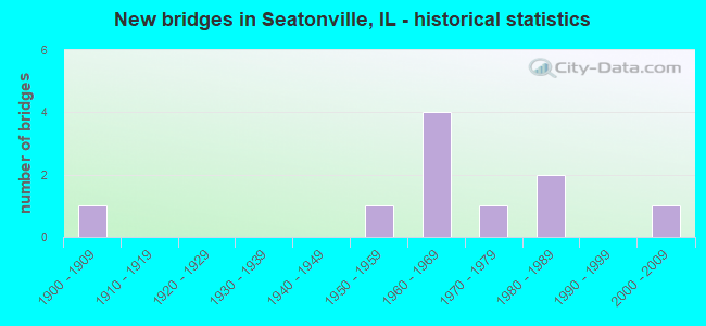
- New bridges - historical statistics
- 11900-1909
- 11950-1959
- 41960-1969
- 11970-1979
- 21980-1989
- 12000-2009


- Bridge Condition - Deck
- 28.6%Very good
- 57.1%Good
- 14.3%Poor

- Bridge Condition - Superstructure
- 14.3%Very good
- 42.9%Good
- 28.6%Satisfactory
- 14.3%Poor

- Bridge Condition - Substructure
- 14.3%Very good
- 71.4%Good
- 14.3%Satisfactory

- Bridge Condition - Channel
- 20.0%Excellent
- 60.0%Good
- 20.0%Satisfactory
Find on map >> Show street view
Structure Number: 60129, Location: 1.4 MI N SEATONVILLE (Lat: 41.387139, Lng: -89.277631), Route carried "on" structure: County highway , Year Built: 1963, Status: Open, Structure Length: 7.62m (25.00ft), Average Daily Traffic: 25 (year 2020), Truck Traffic: 40%, Average Future Daily Traffic: 27 (year 2032), Design Load: HS 15, Features Intersected: I-80, Facility Carried by Structure: TR 364 (3000E)
Minimum Vertical Clearance: 30+ m (98+ ft), Kilometerpoint: 2.221, Lanes on structure: 2, Lanes under structure: 4, Owner: State Highway Agency, Approaching Roadway Width: 9.1m (29.9ft), Skew: 2 degrees, Material/Design: Steel continuous, Design/Construction: Stringer/Multi-beam, Number Of Spans In Main Unit: 4, Length of Maximum Span: 23.6m (77.4ft), Curb or Sidewalk Widths: Left: 0.6m (2.0ft), Right: 0.6m (2.0ft), Curb-To-Curb Width: 7.3m (24.0ft), Out-to-Out Width: 9.1m (29.9ft)
Condition: Deck: Good, Superstructure: Satisfactory, Substructure: Good, Operating Rating: 63.5 metric tons, Method Used To Determine Operating Rating: Load Factor (LF) rating reported by rating factor (RF) method using MS18 loading, Inventory Rating: 34.3 metric tons, Method Used To Determine Inventory Rating: Load Factor (LF) rating reported by rating factor (RF) method using MS18 loading, Structural Evaluation: Equal to present minimum criteria, Deck Geometry: Equal to present minimum criteria, Underclear: High priority of corrective action, Approach Roadway Alignment: Equal to present desirable criteria, Designated Inspection Frequency: Every 24 months, Inspection Date: Febuary 2020, Deck Structure Type: Concrete Cast-file-Place
Find on map >> Show street view
Structure Number: 60133, Location: 2.2 MI W IL 89 (Lat: 41.377069, Lng: -89.258031), Route carried "on" structure: County highway , Year Built: 1962, Status: Open, Structure Length: 8.18m (26.84ft), Average Daily Traffic: 175 (year 2020), Truck Traffic: 4%, Average Future Daily Traffic: 137 (year 2032), Design Load: HS 15, Features Intersected: I-80, Facility Carried by Structure: TR 370 (3100E)
Minimum Vertical Clearance: 30+ m (98+ ft), Kilometerpoint: 4.924, Lanes on structure: 2, Lanes under structure: 4, Owner: State Highway Agency, Approaching Roadway Width: 9.8m (32.2ft), Skew: 3 degrees, Material/Design: Steel continuous, Design/Construction: Stringer/Multi-beam, Number Of Spans In Main Unit: 4, Length of Maximum Span: 25.2m (82.7ft), Curb or Sidewalk Widths: Left: 0.6m (2.0ft), Right: 0.6m (2.0ft), Curb-To-Curb Width: 7.3m (24.0ft), Out-to-Out Width: 9.1m (29.9ft)
Condition: Deck: Good, Superstructure: Good, Substructure: Good, Operating Rating: 52.2 metric tons, Method Used To Determine Operating Rating: Load Factor (LF) rating reported by rating factor (RF) method using MS18 loading, Inventory Rating: 27.2 metric tons, Method Used To Determine Inventory Rating: Load Factor (LF) rating reported by rating factor (RF) method using MS18 loading, Structural Evaluation: Equal to present minimum criteria, Deck Geometry: Somewhat better than minimum adequacy, Underclear: High priority of corrective action, Approach Roadway Alignment: Equal to present desirable criteria, Designated Inspection Frequency: Every 24 months, Other Special Inspection Frequency: Every 48 months, Inspection Date: Febuary 2020, Other Special Inspection Date: October 2018, Deck Structure Type: Concrete Cast-file-Place
Find on map >> Show street view
Structure Number: 60144, Location: IN SEATONVILLE (Lat: 41.363867, Lng: -89.271667), Route carried "on" structure: US 6, Year Built: 1986, Status: Open, Structure Length: 3.20m (10.50ft), Average Daily Traffic: 2,000 (year 2021), Truck Traffic: 5%, Average Future Daily Traffic: 2,951 (year 2032), Design Load: HS 20, Features Intersected: NEGRO CREEK
Minimum Vertical Clearance: 30+ m (98+ ft), Kilometerpoint: 117.254, Lanes on structure: 2, Owner: State Highway Agency, Approaching Roadway Width: 8.6m (28.2ft), Skew: 4 degrees, Material/Design: Prestressed concrete, Design/Construction: Stringer/Multi-beam, Number Of Spans In Main Unit: 1, Length of Maximum Span: 29.9m (98.1ft), Curb-To-Curb Width: 9.8m (32.2ft), Out-to-Out Width: 10.7m (35.1ft)
Condition: Deck: Very good, Superstructure: Satisfactory, Substructure: Very good, Channel: Good, Operating Rating: 84.6 metric tons, Method Used To Determine Operating Rating: Load Factor (LF) rating reported by rating factor (RF) method using MS18 loading, Inventory Rating: 34.3 metric tons, Method Used To Determine Inventory Rating: Load Factor (LF) rating reported by rating factor (RF) method using MS18 loading, Structural Evaluation: Equal to present minimum criteria, Deck Geometry: Somewhat better than minimum adequacy, Waterway Adequacy: Equal to present desirable criteria, Approach Roadway Alignment: Equal to present desirable criteria, Designated Inspection Frequency: Every 24 months, Inspection Date: Febuary 2020, Deck Structure Type: Concrete Cast-file-Place, Wearing Surface/Protective System: Deck Protection: Epoxy Coated Reinforcing
Find on map >> Show street view
Structure Number: 63017, Location: 3 MI NW OF LADD (Lat: 41.413644, Lng: -89.282817), Route carried "on" structure: County highway , Year Built: 2004, Status: Open, Structure Length: 2.44m (8.01ft), Average Daily Traffic: 450 (year 2020), Truck Traffic: 14%, Average Future Daily Traffic: 547 (year 2032), Design Load: HS 20, Features Intersected: BRUSH CREEK, Facility Carried by Structure: CO HIGHWAY 33
Minimum Vertical Clearance: 30+ m (98+ ft), Kilometerpoint: 9.302, Lanes on structure: 2, Owner: County Highway Agency, Approaching Roadway Width: 9.1m (29.9ft), Material/Design: Prestressed concrete, Design/Construction: Box Beam or Girders - Multiple, Number Of Spans In Main Unit: 1, Length of Maximum Span: 23.3m (76.4ft), Curb-To-Curb Width: 9.1m (29.9ft), Out-to-Out Width: 9.1m (29.9ft)
Condition: Deck: Very good, Superstructure: Very good, Substructure: Good, Channel: Excellent, Operating Rating: 44.1 metric tons, Method Used To Determine Operating Rating: Assigned rating based on Load Factor Design (LFD) reported by rating factor (RF) using MS18 loading, Inventory Rating: 32.4 metric tons, Method Used To Determine Inventory Rating: Assigned rating based on Load Factor Design (LFD) reported by rating factor (RF) using MS18 loading, Structural Evaluation: Better than present minimum criteria, Deck Geometry: Equal to present minimum criteria, Waterway Adequacy: Superior to present desirable criteria, Approach Roadway Alignment: Equal to present desirable criteria, Designated Inspection Frequency: Every 48 months, Inspection Date: March 2021, Deck Structure Type: Concrete Precast Panels, Wearing Surface/Protective System: Wearing Surface: Bituminous, Membrane: Built-up
Find on map >> Show street view
Structure Number: 64023, Location: 2.5 M N SEATONVILLE (Lat: 41.407786, Lng: -89.285242), Route carried "on" structure: County highway , Year Built: 1978, Status: Open, Structure Length: 3.57m (11.71ft), Average Daily Traffic: 50 (year 2010), Truck Traffic: 4%, Average Future Daily Traffic: 209 (year 2032), Design Load: HS 20, Features Intersected: BRUSH CREEK, Facility Carried by Structure: TOWNSHIP ROAD 209
Minimum Vertical Clearance: 30+ m (98+ ft), Kilometerpoint: 13.840, Lanes on structure: 2, Owner: Town or Township Highway Agency, Approaching Roadway Width: 7.3m (24.0ft), Skew: 2 degrees, Material/Design: Concrete, Design/Construction: Channel Beam, Number Of Spans In Main Unit: 3, Length of Maximum Span: 11.6m (38.1ft), Curb-To-Curb Width: 7.8m (25.6ft), Out-to-Out Width: 8.0m (26.2ft)
Condition: Deck: Good, Superstructure: Good, Substructure: Good, Channel: Good, Operating Rating: 44.4 metric tons, Method Used To Determine Operating Rating: Assigned rating based on Load Factor Design (LFD) reported by rating factor (RF) using MS18 loading, Inventory Rating: 32.4 metric tons, Method Used To Determine Inventory Rating: Assigned rating based on Load Factor Design (LFD) reported by rating factor (RF) using MS18 loading, Structural Evaluation: Better than present minimum criteria, Deck Geometry: Equal to present minimum criteria, Waterway Adequacy: Equal to present desirable criteria, Approach Roadway Alignment: Equal to present desirable criteria, Designated Inspection Frequency: Every 48 months, Inspection Date: January 2020, Deck Structure Type: Concrete Precast Panels
Find on map >> Show street view
Structure Number: 64138, Location: 0.5 MI. E. SEATONVIL (Lat: 41.369622, Lng: -89.258031), Route carried "on" structure: County highway , Year Built: 1955, Status: Open, Structure Length: 2.68m (8.79ft), Average Daily Traffic: 175 (year 2020), Truck Traffic: 4%, Average Future Daily Traffic: 137 (year 2032), Design Load: HS 15, Features Intersected: NEGRO CREEK, Facility Carried by Structure: TR 370
Minimum Vertical Clearance: 30+ m (98+ ft), Kilometerpoint: 5.842, Lanes on structure: 2, Owner: Town or Township Highway Agency, Approaching Roadway Width: 7.9m (25.9ft), Skew: 1 degrees, Material/Design: Steel continuous, Design/Construction: Stringer/Multi-beam, Number Of Spans In Main Unit: 3, Length of Maximum Span: 9.4m (30.8ft), Curb-To-Curb Width: 6.1m (20.0ft), Out-to-Out Width: 7.4m (24.3ft)
Condition: Deck: Good, Superstructure: Good, Substructure: Good, Channel: Satisfactory, Operating Rating: 38.6 metric tons, Method Used To Determine Operating Rating: Load Factor (LF) rating reported by rating factor (RF) method using MS18 loading, Inventory Rating: 18.1 metric tons, Method Used To Determine Inventory Rating: Load Factor (LF) rating reported by rating factor (RF) method using MS18 loading, Structural Evaluation: Somewhat better than minimum adequacy, Deck Geometry: Meets minimum limits, Waterway Adequacy: Equal to present desirable criteria, Approach Roadway Alignment: Equal to present minimum criteria, Designated Inspection Frequency: Every 24 months, Inspection Date: December 2021, Deck Structure Type: Concrete Cast-file-Place, Wearing Surface/Protective System: Wearing Surface: Bituminous
Find on map >> Show street view
Structure Number: 6602, Location: SEATONVILLE (Lat: 41.363256, Lng: -89.274258), Route carried "on" structure: County highway , Year Built: 1987, Status: Open, Structure Length: 1.34m (4.40ft), Average Daily Traffic: 475 (year 2020), Truck Traffic: 6%, Average Future Daily Traffic: 1,148 (year 2032), Design Load: HS 20, Features Intersected: Negro Creek, Facility Carried by Structure: FAS1240/CH14/Peru
Minimum Vertical Clearance: 30+ m (98+ ft), Kilometerpoint: 0.113, Lanes on structure: 2, Owner: City or Municipal Highway Agency, Approaching Roadway Width: 11.0m (36.1ft), Material/Design: Prestressed concrete, Design/Construction: Box Beam or Girders - Multiple, Number Of Spans In Main Unit: 1, Length of Maximum Span: 12.6m (41.3ft), Curb or Sidewalk Widths: Left: 0.0m, Right: 1.5m (4.9ft), Curb-To-Curb Width: 9.1m (29.9ft), Out-to-Out Width: 11.0m (36.1ft)
Condition: Deck: Poor, Superstructure: Poor, Substructure: Satisfactory, Channel: Good, Operating Rating: 60.3 metric tons, Method Used To Determine Operating Rating: Load Factor (LF) rating reported by rating factor (RF) method using MS18 loading, Inventory Rating: 36.0 metric tons, Method Used To Determine Inventory Rating: Load Factor (LF) rating reported by rating factor (RF) method using MS18 loading, Structural Evaluation: Meets minimum limits, Deck Geometry: Equal to present minimum criteria, Waterway Adequacy: Superior to present desirable criteria, Approach Roadway Alignment: Equal to present desirable criteria, Designated Inspection Frequency: Every 24 months, Inspection Date: December 2021, Deck Structure Type: Concrete Precast Panels, Wearing Surface/Protective System: Wearing Surface: Bituminous, Membrane: Built-up
Find on map >> Show street view
Structure Number: 60129, Location: 1.4 MI N SEATONVILLE (Lat: 41.387139, Lng: -89.277631), Route carried "under" structure: Interstate 80, Year Built: 1963, Structure Length: 0. m, Average Daily Traffic: 22,100 (year 2021), Truck Traffic: 29%, Features Intersected: I-80, Facility Carried by Structure: TR 364 (3000E)
Minimum Vertical Clearance: 5.00m (16.40ft), Kilometerpoint: 107.437, Lanes on structure: 2, Lanes under structure: 4, Material/Design: Steel continuous, Design/Construction: Stringer/Multi-beam, Length of Maximum Span: 23.6m (77.4ft)
Find on map >> Show street view
Structure Number: 60133, Location: 2.2 MI W IL 89 (Lat: 41.377069, Lng: -89.258031), Route carried "under" structure: Interstate 80, Year Built: 1962, Structure Length: 0. m, Average Daily Traffic: 22,100 (year 2021), Truck Traffic: 29%, Features Intersected: I-80, Facility Carried by Structure: TR 370 (3100E)
Minimum Vertical Clearance: 5.33m (17.49ft), Kilometerpoint: 109.416, Lanes on structure: 2, Lanes under structure: 4, Material/Design: Steel continuous, Design/Construction: Stringer/Multi-beam, Length of Maximum Span: 25.2m (82.7ft)
Find on map >> Show street view
Structure Number: 6994, Location: SEATONVILLE (Lat: 41.357739, Lng: -89.277678), Route carried "under" structure: County highway , Year Built: 1900, Structure Length: 0. m, Average Daily Traffic: 75 (year 2010), Features Intersected: TR 362, Facility Carried by Structure: NYC RR
Minimum Vertical Clearance: 5.21m (17.09ft), Kilometerpoint: 0.097, Lanes under structure: 2, Material/Design: Steel, Design/Construction: Box Beam or Girders - Multiple, Length of Maximum Span: 9.1m (29.9ft)