Bridge Statistics for Seal Beach, California (CA)
Condition, Traffic, Stress, Structural Evaluation, Project Costs
- National Bridge Inventory (NBI) Statistics
- 42Number of bridges
- 1,020ft / 311mTotal length
- $31,000Total costs
- 4,014,635Total average daily traffic
- 138,359Total average daily truck traffic
- National Bridge Inventory (NBI) Registered Bridges for Seal Beach
- No street view available for this location
- New bridges - historical statistics
- 11940-1949
- 21950-1959
- 171960-1969
- 11980-1989
- 212010-2019
- Bridge Condition - Deck
- 57.9%Good
- 42.1%Fair
- Bridge Condition - Superstructure
- 78.9%Good
- 21.1%Fair
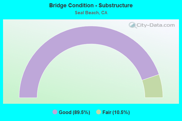
- Bridge Condition - Substructure
- 89.5%Good
- 10.5%Fair
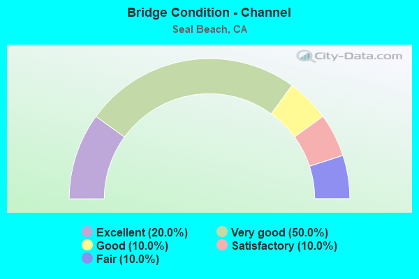
- Bridge Condition - Channel
- 20.0%Excellent
- 50.0%Very good
- 10.0%Good
- 10.0%Satisfactory
- 10.0%Fair
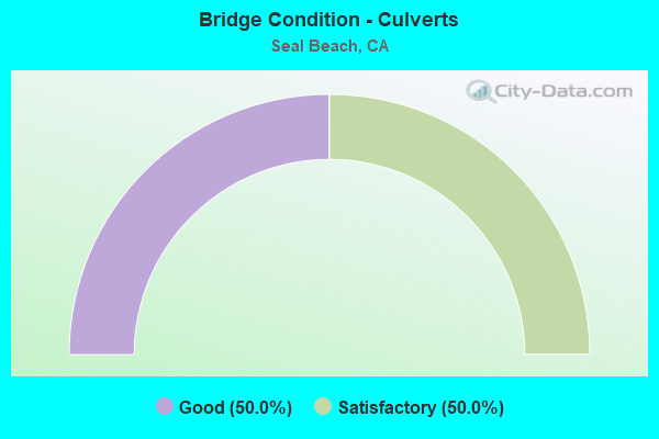
- Bridge Condition - Culverts
- 50.0%Good
- 50.0%Satisfactory
Find on map >> Show street view
Structure Number: 1CA8923, Location: NWS SEAL BEACH (Lat: 33.795806, Lng: -118.035194), Route carried "on" structure: Other road , Year Built: 1966, Status: Open, Structure Length: 0.62m (2.03ft), Average Daily Traffic: 50 (year 2015), Average Future Daily Traffic: 50 (year 2037), Features Intersected: BOLSA CHICA CHANNEL, Facility Carried by Structure: GOLF ROAD
Minimum Vertical Clearance: 30+ m (98+ ft), Kilometerpoint: 0.000, Lanes on structure: 2, Owner: Navy/Marines, Approaching Roadway Width: 6.1m (20.0ft), Material/Design: Concrete, Design/Construction: Culvert, Number Of Spans In Main Unit: 2, Length of Maximum Span: 3.0m (9.8ft), Curb-To-Curb Width: 6.1m (20.0ft), Out-to-Out Width: 6.6m (21.7ft)
Condition: Channel: Satisfactory, Culverts: Good, Operating Rating: 36.2 metric tons, Method Used To Determine Operating Rating: Field evaluation and documented engineering judgment, Inventory Rating: 32.7 metric tons, Method Used To Determine Inventory Rating: Field evaluation and documented engineering judgment, Structural Evaluation: Better than present minimum criteria, Deck Geometry: Somewhat better than minimum adequacy, Waterway Adequacy: Equal to present desirable criteria, Approach Roadway Alignment: Equal to present minimum criteria, Length Of Structure Improvement: 0.62m (2.03ft), Designated Inspection Frequency: Every 24 months, Inspection Date: July 2021, Bridge Improvement Cost: $3,000, Roadway Improvement Cost: $28,000, Total Project Cost: $31,000 ( Estimate for 2021)
Find on map >> Show street view
Structure Number: 55 0062, Location: 12-ORA-074-10.44-SJCP (Lat: 33.573347, Lng: -117.541342), Route carried "on" structure: State highway 74, Year Built: 1987, Status: Open, Structure Length: 5.79m (19.00ft), Average Daily Traffic: 9,800 (year 2012), Truck Traffic: 5%, Average Future Daily Traffic: 23,300 (year 2040), Design Load: HS 20, Features Intersected: SAN JUAN CREEK
Minimum Vertical Clearance: 30+ m (98+ ft), Kilometerpoint: 10.440, Lanes on structure: 2, Owner: State Highway Agency, Approaching Roadway Width: 12.2m (40.0ft), Skew: 3 degrees, Material/Design: Prestressed concrete continuous, Design/Construction: Box Beam or Girders - Multiple, Number Of Spans In Main Unit: 2, Length of Maximum Span: 28.7m (94.2ft), Curb-To-Curb Width: 12.2m (40.0ft), Out-to-Out Width: 13.3m (43.6ft)
Condition: Deck: Fair, Superstructure: Good, Substructure: Fair, Channel: Very good, Operating Rating: 54.1 metric tons, Method Used To Determine Operating Rating: Assigned rating based on Load Factor Design (LFD) reported in metric tons, Inventory Rating: 32.4 metric tons, Method Used To Determine Inventory Rating: Assigned rating based on Load Factor Design (LFD) reported in metric tons, Structural Evaluation: Somewhat better than minimum adequacy, Deck Geometry: Somewhat better than minimum adequacy, Waterway Adequacy: Equal to present desirable criteria, Approach Roadway Alignment: Better than present minimum criteria, Designated Inspection Frequency: Every 24 months, Inspection Date: July 2021, Deck Structure Type: Concrete Cast-file-Place
Find on map >> Show street view
Structure Number: 55 0065, Location: 12-ORA-001-32.36-SLB (Lat: 33.738631, Lng: -118.089822), Route carried "on" structure: State highway 1, Year Built: 1944, Status: Open, Structure Length: 3.96m (12.99ft), Average Daily Traffic: 41,000 (year 2012), Average Future Daily Traffic: 53,686 (year 2040), Features Intersected: KITT HWY, USN RR
Minimum Vertical Clearance: 30+ m (98+ ft), Kilometerpoint: 32.360, Lanes on structure: 4, Base Highway Network: Yes (, Subroute: 1), Owner: State Highway Agency, Approaching Roadway Width: 23.9m (78.4ft), Skew: 30 degrees, Material/Design: Concrete continuous, Design/Construction: Slab, Number Of Spans In Main Unit: 6, Length of Maximum Span: 10.4m (34.1ft), Curb or Sidewalk Widths: Left: 0.7m (2.3ft), Right: 0.7m (2.3ft), Curb-To-Curb Width: 23.9m (78.4ft), Out-to-Out Width: 26.4m (86.6ft)
Condition: Deck: Good, Superstructure: Good, Substructure: Good, Operating Rating: 44.4 metric tons, Method Used To Determine Operating Rating: Load Factor (LF), Inventory Rating: 26.6 metric tons, Method Used To Determine Inventory Rating: Load Factor (LF), Structural Evaluation: Equal to present minimum criteria, Deck Geometry: Superior to present desirable criteria, Underclear: High priority of corrective action, Approach Roadway Alignment: Equal to present desirable criteria, Designated Inspection Frequency: Every 24 months, Inspection Date: June 2021, Deck Structure Type: Concrete Cast-file-Place
Find on map >> Show street view
Structure Number: 55 0334, Location: 12-ORA-405-20.77-SLB (Lat: 33.774839, Lng: -118.042908), Route carried "on" structure: Interstate 405, Year Built: 1959, Year Reconstructed: 1965, Status: Open, Structure Length: 1.16m (3.81ft), Average Daily Traffic: 374,000 (year 2013), Truck Traffic: 3%, Average Future Daily Traffic: 455,000 (year 2038), Features Intersected: BOLSA CHICA DITCH
Minimum Vertical Clearance: 30+ m (98+ ft), Kilometerpoint: 20.770, Lanes on structure: 10, Base Highway Network: Yes (Inventory Route: 4, Subroute: 1), Owner: State Highway Agency, Approaching Roadway Width: 46.6m (152.9ft), Skew: 29 degrees, Material/Design: Concrete, Design/Construction: Culvert, Number Of Spans In Main Unit: 3, Length of Maximum Span: 3.7m (12.1ft), Curb-To-Curb Width: 46.6m (152.9ft), Out-to-Out Width: 47.6m (156.2ft)
Condition: Channel: Very good, Culverts: Satisfactory, Operating Rating: 54.1 metric tons, Method Used To Determine Operating Rating: Field evaluation and documented engineering judgment, Inventory Rating: 32.4 metric tons, Method Used To Determine Inventory Rating: Field evaluation and documented engineering judgment, Structural Evaluation: Equal to present minimum criteria, Deck Geometry: Superior to present desirable criteria, Waterway Adequacy: Equal to present desirable criteria, Approach Roadway Alignment: Better than present minimum criteria, Designated Inspection Frequency: Every 24 months, Inspection Date: September 2021
Find on map >> Show street view
Structure Number: 55 0412L, Location: 12-ORA-605-3.48-SLB (Lat: 33.783717, Lng: -118.091786), Route carried "on" structure: Interstate 605, Year Built: 1966, Status: Open, Structure Length: 9.66m (31.69ft), Average Daily Traffic: 95,000 (year 2013), Truck Traffic: 5%, Average Future Daily Traffic: 106,253 (year 2038), Design Load: HS 20, Features Intersected: INTERSTATE 405
Minimum Vertical Clearance: 30+ m (98+ ft), Kilometerpoint: 3.480, Lanes on structure: 4, Lanes under structure: 9, Base Highway Network: Yes (Inventory Route: 6, Subroute: 2), Owner: State Highway Agency, Approaching Roadway Width: 21.0m (68.9ft), Skew: 4 degrees, Material/Design: Concrete continuous, Design/Construction: Box Beam or Girders - Multiple, Number Of Spans In Main Unit: 4, Length of Maximum Span: 33.5m (109.9ft), Curb-To-Curb Width: 21.0m (68.9ft), Out-to-Out Width: 21.9m (71.9ft)
Condition: Deck: Good, Superstructure: Good, Substructure: Good, Operating Rating: 54.1 metric tons, Method Used To Determine Operating Rating: Assigned rating based on Load Factor Design (LFD) reported in metric tons, Inventory Rating: 32.4 metric tons, Method Used To Determine Inventory Rating: Assigned rating based on Load Factor Design (LFD) reported in metric tons, Structural Evaluation: Better than present minimum criteria, Deck Geometry: Better than present minimum criteria, Underclear: High priority of corrective action, Approach Roadway Alignment: Equal to present desirable criteria, Designated Inspection Frequency: Every 24 months, Inspection Date: September 2021, Deck Structure Type: Concrete Cast-file-Place
Find on map >> Show street view
Structure Number: 55 0413F, Location: 12-ORA-405-24.11-SLB (Lat: 33.786461, Lng: -118.089778), Route carried "on" structure: Ramp Interstate 405, Year Built: 1966, Status: Open, Structure Length: 54.74m (179.59ft), Average Daily Traffic: 22,800 (year 2013), Truck Traffic: 3%, Average Future Daily Traffic: 24,022 (year 2038), Design Load: HS 20+Mod, Features Intersected: RTE 405, 605, CONN, RIV
Minimum Vertical Clearance: 30+ m (98+ ft), Kilometerpoint: 24.110, Lanes on structure: 2, Lanes under structure: 19, Base Highway Network: Yes, Owner: State Highway Agency, Approaching Roadway Width: 8.5m (27.9ft), Skew: 9 degrees, Material/Design: Concrete continuous, Design/Construction: Box Beam or Girders - Multiple, Number Of Spans In Main Unit: 17, Length of Maximum Span: 37.5m (123.0ft), Curb or Sidewalk Widths: Left: 0.6m (2.0ft), Right: 0.6m (2.0ft), Curb-To-Curb Width: 8.5m (27.9ft), Out-to-Out Width: 10.4m (34.1ft)
Condition: Deck: Good, Superstructure: Good, Substructure: Fair, Channel: Very good, Operating Rating: 54.1 metric tons, Method Used To Determine Operating Rating: Assigned rating based on Load Factor Design (LFD) reported in metric tons, Inventory Rating: 32.4 metric tons, Method Used To Determine Inventory Rating: Assigned rating based on Load Factor Design (LFD) reported in metric tons, Structural Evaluation: Somewhat better than minimum adequacy, Deck Geometry: High priority of corrective action, Underclear: Somewhat better than minimum adequacy, Waterway Adequacy: Equal to present desirable criteria, Approach Roadway Alignment: Somewhat better than minimum adequacy, Designated Inspection Frequency: Every 24 months, Underwater Inspection Frequency: Every 60 months, Inspection Date: September 2021, Underwater Inspection Date: March 2021, Deck Structure Type: Concrete Cast-file-Place
Find on map >> Show street view
Structure Number: 55 0426G, Location: 12-ORA-022-R0.38-SLB (Lat: 33.779153, Lng: -118.090861), Route carried "on" structure: Ramp State highway 22, Year Built: 1966, Status: Open, Structure Length: 5.21m (17.09ft), Average Daily Traffic: 22,000 (year 2020), Truck Traffic: 3%, Average Future Daily Traffic: 23,862 (year 2038), Design Load: HS 20, Features Intersected: S605-S405 CONNECTOR
Minimum Vertical Clearance: 30+ m (98+ ft), Kilometerpoint: 0.380, Lanes on structure: 1, Lanes under structure: 2, Base Highway Network: Yes (, Subroute: 1), Owner: State Highway Agency, Approaching Roadway Width: 14.6m (47.9ft), Skew: 9 degrees, Material/Design: Concrete, Design/Construction: Box Beam or Girders - Multiple, Number Of Spans In Main Unit: 1, Length of Maximum Span: 50.3m (165.0ft), Curb-To-Curb Width: 14.6m (47.9ft), Out-to-Out Width: 14.6m (47.9ft)
Condition: Deck: Good, Superstructure: Fair, Substructure: Good, Operating Rating: 54.1 metric tons, Method Used To Determine Operating Rating: Assigned rating based on Load Factor Design (LFD) reported in metric tons, Inventory Rating: 32.4 metric tons, Method Used To Determine Inventory Rating: Assigned rating based on Load Factor Design (LFD) reported in metric tons, Structural Evaluation: Somewhat better than minimum adequacy, Deck Geometry: Superior to present desirable criteria, Underclear: Better than present minimum criteria, Approach Roadway Alignment: Equal to present desirable criteria, Length Of Structure Improvement: 5.21m (17.09ft), Designated Inspection Frequency: Every 24 months, Inspection Date: April 2020
Find on map >> Show street view
Structure Number: 55 0428G, Location: 12-ORA-022-R0.37-SLB (Lat: 33.774886, Lng: -118.090758), Route carried "on" structure: Ramp State highway 22, Year Built: 1966, Status: Open, Structure Length: 12.28m (40.29ft), Average Daily Traffic: 21,500 (year 2020), Truck Traffic: 3%, Average Future Daily Traffic: 23,862 (year 2038), Design Load: HS 20+Mod, Features Intersected: STATE ROUTE 22
Minimum Vertical Clearance: 30+ m (98+ ft), Kilometerpoint: 0.370, Lanes on structure: 2, Lanes under structure: 4, Base Highway Network: Yes, Owner: State Highway Agency, Approaching Roadway Width: 8.5m (27.9ft), Skew: 9 degrees, Material/Design: Concrete continuous, Design/Construction: Box Beam or Girders - Multiple, Number Of Spans In Main Unit: 5, Length of Maximum Span: 36.3m (119.1ft), Curb or Sidewalk Widths: Left: 0.6m (2.0ft), Right: 0.6m (2.0ft), Curb-To-Curb Width: 8.5m (27.9ft), Out-to-Out Width: 10.4m (34.1ft)
Condition: Deck: Good, Superstructure: Good, Substructure: Good, Operating Rating: 27.5 metric tons, Method Used To Determine Operating Rating: Load and Resistance Factor Rating (LRFR) rating reported by rating factor(RF) method using HL-93 loadings, Inventory Rating: 21.4 metric tons, Method Used To Determine Inventory Rating: Load and Resistance Factor Rating (LRFR) rating reported by rating factor(RF) method using HL-93 loadings, Structural Evaluation: Somewhat better than minimum adequacy, Deck Geometry: High priority of corrective action, Underclear: Equal to present minimum criteria, Approach Roadway Alignment: Better than present minimum criteria, Designated Inspection Frequency: Every 24 months, Inspection Date: April 2020, Deck Structure Type: Concrete Cast-file-Place, Wearing Surface/Protective System: Wearing Surface: Integral Concrete
Find on map >> Show street view
Structure Number: 55 0441, Location: 12-ORA-405-24.10-SLB (Lat: 33.785497, Lng: -118.092422), Route carried "on" structure: Interstate 405, Year Built: 1965, Status: Open, Structure Length: 1.10m (3.61ft), Average Daily Traffic: 255,000 (year 2013), Truck Traffic: 3%, Average Future Daily Traffic: 319,000 (year 2038), Design Load: HS 20+Mod, Features Intersected: LOS ALAMITOS CHANNEL
Minimum Vertical Clearance: 30+ m (98+ ft), Kilometerpoint: 24.100, Lanes on structure: 10, Base Highway Network: Yes (Inventory Route: 4, Subroute: 1), Owner: State Highway Agency, Approaching Roadway Width: 50.6m (166.0ft), Skew: 22 degrees, Material/Design: Concrete, Design/Construction: Culvert, Number Of Spans In Main Unit: 3, Length of Maximum Span: 3.7m (12.1ft), Curb-To-Curb Width: 50.6m (166.0ft), Out-to-Out Width: 51.6m (169.3ft)
Condition: Channel: Good, Culverts: Satisfactory, Operating Rating: 54.1 metric tons, Method Used To Determine Operating Rating: Field evaluation and documented engineering judgment, Inventory Rating: 32.4 metric tons, Method Used To Determine Inventory Rating: Field evaluation and documented engineering judgment, Structural Evaluation: Equal to present minimum criteria, Deck Geometry: Superior to present desirable criteria, Waterway Adequacy: Better than present minimum criteria, Approach Roadway Alignment: Equal to present desirable criteria, Designated Inspection Frequency: Every 24 months, Inspection Date: September 2021
Find on map >> Show street view
Structure Number: 55 109, Location: 12-ORA-074-14.97 (Lat: 33.592517, Lng: -117.476661), Route carried "on" structure: State highway 74, Year Built: 2010, Status: Open, Structure Length: 2.22m (7.28ft), Average Daily Traffic: 9,800 (year 2009), Truck Traffic: 7%, Average Future Daily Traffic: 13,400 (year 2038), Design Load: HS 20+Mod, Features Intersected: HILLSIDE
Minimum Vertical Clearance: 30+ m (98+ ft), Kilometerpoint: 14.970, Lanes on structure: 2, Owner: State Highway Agency, Approaching Roadway Width: 9.6m (31.5ft), Material/Design: Concrete, Design/Construction: Box Beam or Girders - Single/Spread, Number Of Spans In Main Unit: 1, Length of Maximum Span: 22.2m (72.8ft), Curb-To-Curb Width: 9.6m (31.5ft), Out-to-Out Width: 10.1m (33.1ft)
Condition: Deck: Good, Superstructure: Good, Substructure: Good, Operating Rating: 54.1 metric tons, Method Used To Determine Operating Rating: Assigned rating based on Load Factor Design (LFD) reported in metric tons, Inventory Rating: 32.4 metric tons, Method Used To Determine Inventory Rating: Assigned rating based on Load Factor Design (LFD) reported in metric tons, Structural Evaluation: Better than present minimum criteria, Deck Geometry: High priority of corrective action, Approach Roadway Alignment: Equal to present desirable criteria, Designated Inspection Frequency: Every 48 months, Inspection Date: July 2019, Deck Structure Type: Concrete Cast-file-Place, Wearing Surface/Protective System: Wearing Surface: Bituminous
Find on map >> Show street view
Structure Number: 55 1096G, Location: 12-ORA-022-R0.39-SLB (Lat: 33.783519, Lng: -118.091289), Route carried "on" structure: Ramp State highway 22, Year Built: 2014, Status: Open, Structure Length: 10.42m (34.19ft), Average Daily Traffic: 10,000 (year 2020), Truck Traffic: 2%, Average Future Daily Traffic: 12,000 (year 2038), Design Load: HL 93, Features Intersected: RTE405
Minimum Vertical Clearance: 30+ m (98+ ft), Kilometerpoint: 0.390, Lanes on structure: 1, Lanes under structure: 10, Base Highway Network: Yes (, Subroute: 1), Owner: State Highway Agency, Approaching Roadway Width: 8.1m (26.6ft), Material/Design: Prestressed concrete continuous, Design/Construction: Box Beam or Girders - Multiple, Number Of Spans In Main Unit: 2, Length of Maximum Span: 52.1m (170.9ft), Curb-To-Curb Width: 8.1m (26.6ft), Out-to-Out Width: 9.1m (29.9ft)
Condition: Deck: Good, Superstructure: Good, Substructure: Good, Operating Rating: 42.1 metric tons, Method Used To Determine Operating Rating: Assigned ratings based on Load and Resistance Factor Design (LRFD) reported by rating factor (RF) using HL93 loadings, Inventory Rating: 32.4 metric tons, Method Used To Determine Inventory Rating: Assigned ratings based on Load and Resistance Factor Design (LRFD) reported by rating factor (RF) using HL93 loadings, Structural Evaluation: Better than present minimum criteria, Deck Geometry: Superior to present desirable criteria, Underclear: High priority of corrective action, Approach Roadway Alignment: Equal to present desirable criteria, Designated Inspection Frequency: Every 24 months, Inspection Date: April 2020, Deck Structure Type: Concrete Cast-file-Place
Find on map >> Show street view
Structure Number: 55 1097G, Location: 12-ORA-022-R0.39-SLB (Lat: 33.783731, Lng: -118.091386), Route carried "on" structure: Ramp State highway 22, Year Built: 2014, Status: Open, Structure Length: 14.02m (46.00ft), Average Daily Traffic: 15,000 (year 2020), Truck Traffic: 3%, Average Future Daily Traffic: 18,000 (year 2038), Design Load: HL 93, Features Intersected: RTE405
Minimum Vertical Clearance: 30+ m (98+ ft), Kilometerpoint: 0.390, Lanes on structure: 2, Lanes under structure: 10, Base Highway Network: Yes (, Subroute: 1), Owner: State Highway Agency, Approaching Roadway Width: 11.8m (38.7ft), Material/Design: Prestressed concrete continuous, Design/Construction: Box Beam or Girders - Multiple, Number Of Spans In Main Unit: 4, Length of Maximum Span: 46.0m (150.9ft), Curb-To-Curb Width: 11.8m (38.7ft), Out-to-Out Width: 12.8m (42.0ft)
Condition: Deck: Good, Superstructure: Good, Substructure: Good, Operating Rating: 42.1 metric tons, Method Used To Determine Operating Rating: Assigned ratings based on Load and Resistance Factor Design (LRFD) reported by rating factor (RF) using HL93 loadings, Inventory Rating: 32.4 metric tons, Method Used To Determine Inventory Rating: Assigned ratings based on Load and Resistance Factor Design (LRFD) reported by rating factor (RF) using HL93 loadings, Structural Evaluation: Better than present minimum criteria, Deck Geometry: Superior to present desirable criteria, Underclear: High priority of corrective action, Approach Roadway Alignment: Equal to present desirable criteria, Designated Inspection Frequency: Every 24 months, Inspection Date: April 2020, Deck Structure Type: Concrete Cast-file-Place
Find on map >> Show street view
Structure Number: 55 1098E, Location: 12-ORA-405-24.02-SLB (Lat: 33.776519, Lng: -118.088650), Route carried "on" structure: Alternate Interstate 405, Year Built: 2014, Status: Open, Structure Length: 88.45m (290.19ft), Average Daily Traffic: 5,000 (year 2012), Truck Traffic: 1%, Average Future Daily Traffic: 6,000 (year 2038), Design Load: HL 93, Features Intersected: RT405 & CONN.
Minimum Vertical Clearance: 30+ m (98+ ft), Kilometerpoint: 24.020, Lanes on structure: 2, Lanes under structure: 18, Base Highway Network: Yes (, Subroute: 1), Owner: State Highway Agency, Approaching Roadway Width: 17.0m (55.8ft), Skew: 39 degrees, Material/Design: Prestressed concrete continuous, Design/Construction: Box Beam or Girders - Multiple, Number Of Spans In Main Unit: 15, Length of Maximum Span: 62.5m (205.1ft), Curb-To-Curb Width: 17.0m (55.8ft), Out-to-Out Width: 18.0m (59.1ft)
Condition: Deck: Fair, Superstructure: Good, Substructure: Good, Operating Rating: 42.1 metric tons, Method Used To Determine Operating Rating: Assigned ratings based on Load and Resistance Factor Design (LRFD) reported by rating factor (RF) using HL93 loadings, Inventory Rating: 32.4 metric tons, Method Used To Determine Inventory Rating: Assigned ratings based on Load and Resistance Factor Design (LRFD) reported by rating factor (RF) using HL93 loadings, Structural Evaluation: Better than present minimum criteria, Deck Geometry: Superior to present desirable criteria, Underclear: Meets minimum limits, Approach Roadway Alignment: Equal to present desirable criteria, Designated Inspection Frequency: Every 24 months, Inspection Date: September 2021, Deck Structure Type: Concrete Cast-file-Place
Find on map >> Show street view
Structure Number: 55 1099, Location: 12-ORA-405-22.64-SLB (Lat: 33.774336, Lng: -118.075033), Route carried "on" structure: City street , Year Built: 2014, Status: Open, Structure Length: 14.40m (47.24ft), Average Daily Traffic: 20,000 (year 2020), Truck Traffic: 3%, Average Future Daily Traffic: 22,295 (year 2042), Design Load: HL 93, Features Intersected: STATE ROUTE 405, Facility Carried by Structure: SEAL BEACH BLVD
Minimum Vertical Clearance: 30+ m (98+ ft), Kilometerpoint: 0.000, Lanes on structure: 7, Lanes under structure: 18, Base Highway Network: Yes, Owner: State Highway Agency, Approaching Roadway Width: 36.0m (118.1ft), Skew: 3 degrees, Material/Design: Prestressed concrete continuous, Design/Construction: Box Beam or Girders - Multiple, Number Of Spans In Main Unit: 2, Length of Maximum Span: 78.5m (257.5ft), Curb or Sidewalk Widths: Left: 1.5m (4.9ft), Right: 1.5m (4.9ft), Curb-To-Curb Width: 36.0m (118.1ft), Out-to-Out Width: 39.6m (129.9ft)
Condition: Deck: Fair, Superstructure: Good, Substructure: Good, Operating Rating: 42.1 metric tons, Method Used To Determine Operating Rating: Assigned ratings based on Load and Resistance Factor Design (LRFD) reported by rating factor (RF) using HL93 loadings, Inventory Rating: 32.4 metric tons, Method Used To Determine Inventory Rating: Assigned ratings based on Load and Resistance Factor Design (LRFD) reported by rating factor (RF) using HL93 loadings, Structural Evaluation: Better than present minimum criteria, Deck Geometry: Superior to present desirable criteria, Underclear: Meets minimum limits, Approach Roadway Alignment: Equal to present desirable criteria, Designated Inspection Frequency: Every 24 months, Inspection Date: September 2021, Deck Structure Type: Concrete Cast-file-Place
Find on map >> Show street view
Structure Number: 55 1101F, Location: 12-ORA-405-20.75-SLB (Lat: 33.774031, Lng: -118.044753), Route carried "on" structure: Ramp Interstate 405, Year Built: 2015, Status: Open, Structure Length: 23.13m (75.89ft), Average Daily Traffic: 50,000 (year 2013), Truck Traffic: 3%, Average Future Daily Traffic: 60,000 (year 2038), Design Load: HL 93, Features Intersected: INTERSTATE 405
Minimum Vertical Clearance: 30+ m (98+ ft), Kilometerpoint: 20.750, Lanes on structure: 3, Lanes under structure: 11, Base Highway Network: Yes (Inventory Route: 4, Subroute: 1), Owner: State Highway Agency, Approaching Roadway Width: 17.0m (55.8ft), Skew: 4 degrees, Material/Design: Prestressed concrete continuous, Design/Construction: Box Beam or Girders - Multiple, Number Of Spans In Main Unit: 3, Length of Maximum Span: 91.4m (299.9ft), Curb-To-Curb Width: 17.0m (55.8ft), Out-to-Out Width: 18.0m (59.1ft)
Condition: Deck: Fair, Superstructure: Good, Substructure: Good, Operating Rating: 42.1 metric tons, Method Used To Determine Operating Rating: Assigned ratings based on Load and Resistance Factor Design (LRFD) reported by rating factor (RF) using HL93 loadings, Inventory Rating: 32.4 metric tons, Method Used To Determine Inventory Rating: Assigned ratings based on Load and Resistance Factor Design (LRFD) reported by rating factor (RF) using HL93 loadings, Structural Evaluation: Better than present minimum criteria, Deck Geometry: Superior to present desirable criteria, Underclear: Meets minimum limits, Approach Roadway Alignment: Equal to present desirable criteria, Designated Inspection Frequency: Every 24 months, Inspection Date: September 2021, Deck Structure Type: Concrete Cast-file-Place
Find on map >> Show street view
Structure Number: 55 1102, Location: 12-ORA-022-R0.92-SLB (Lat: 33.774486, Lng: -118.037761), Route carried "on" structure: City street , Year Built: 2015, Status: Open, Structure Length: 10.85m (35.60ft), Average Daily Traffic: 20,000 (year 2020), Truck Traffic: 3%, Average Future Daily Traffic: 25,000 (year 2040), Design Load: HL 93, Features Intersected: ROUTE 22, Facility Carried by Structure: BOLSA CHICA ROAD
Minimum Vertical Clearance: 30+ m (98+ ft), Kilometerpoint: 0.000, Lanes on structure: 7, Lanes under structure: 9, Owner: State Highway Agency, Approaching Roadway Width: 31.7m (104.0ft), Skew: 3 degrees, Material/Design: Prestressed concrete continuous, Design/Construction: Box Beam or Girders - Multiple, Number Of Spans In Main Unit: 2, Length of Maximum Span: 55.1m (180.8ft), Curb or Sidewalk Widths: Left: 3.0m (9.8ft), Right: 0.0m, Curb-To-Curb Width: 31.7m (104.0ft), Out-to-Out Width: 35.5m (116.5ft)
Condition: Deck: Fair, Superstructure: Good, Substructure: Good, Operating Rating: 42.1 metric tons, Method Used To Determine Operating Rating: Assigned ratings based on Load and Resistance Factor Design (LRFD) reported by rating factor (RF) using HL93 loadings, Inventory Rating: 32.4 metric tons, Method Used To Determine Inventory Rating: Assigned ratings based on Load and Resistance Factor Design (LRFD) reported by rating factor (RF) using HL93 loadings, Structural Evaluation: Better than present minimum criteria, Deck Geometry: Superior to present desirable criteria, Underclear: Meets minimum limits, Approach Roadway Alignment: Equal to present desirable criteria, Designated Inspection Frequency: Every 24 months, Inspection Date: November 2020, Deck Structure Type: Concrete Cast-file-Place
Find on map >> Show street view
Structure Number: 55 1103E, Location: 12-ORA-405-20.67-SLB (Lat: 33.774889, Lng: -118.041361), Route carried "on" structure: Ramp Interstate 405, Year Built: 2015, Status: Open, Structure Length: 33.83m (110.99ft), Average Daily Traffic: 5,000 (year 2013), Truck Traffic: 1%, Average Future Daily Traffic: 6,000 (year 2038), Design Load: HL 93, Features Intersected: I-405 NB
Minimum Vertical Clearance: 30+ m (98+ ft), Kilometerpoint: 20.670, Lanes on structure: 2, Lanes under structure: 5, Owner: State Highway Agency, Approaching Roadway Width: 17.0m (55.8ft), Skew: 30 degrees, Material/Design: Prestressed concrete continuous, Design/Construction: Box Beam or Girders - Multiple, Number Of Spans In Main Unit: 5, Length of Maximum Span: 76.2m (250.0ft), Curb-To-Curb Width: 17.0m (55.8ft), Out-to-Out Width: 18.0m (59.1ft)
Condition: Deck: Good, Superstructure: Good, Substructure: Good, Operating Rating: 42.1 metric tons, Method Used To Determine Operating Rating: Assigned ratings based on Load and Resistance Factor Design (LRFD) reported by rating factor (RF) using HL93 loadings, Inventory Rating: 32.4 metric tons, Method Used To Determine Inventory Rating: Assigned ratings based on Load and Resistance Factor Design (LRFD) reported by rating factor (RF) using HL93 loadings, Structural Evaluation: Better than present minimum criteria, Deck Geometry: Superior to present desirable criteria, Underclear: Meets minimum limits, Approach Roadway Alignment: Equal to present desirable criteria, Designated Inspection Frequency: Every 24 months, Inspection Date: September 2021, Deck Structure Type: Concrete Cast-file-Place
Find on map >> Show street view
Structure Number: 55C0041R, Location: 0.8 MI W/O SEAL BEACH BL. (Lat: 33.759478, Lng: -118.091978), Route carried "on" structure: City street , Year Built: 1964, Status: Open, Structure Length: 2.07m (6.79ft), Average Daily Traffic: 13,000 (year 2020), Truck Traffic: 1%, Average Future Daily Traffic: 23,671 (year 2041), Design Load: HS 20, Features Intersected: LOS ALAMITOS CHANNEL, Facility Carried by Structure: WESTMINSTER AVE-EB
Minimum Vertical Clearance: 30+ m (98+ ft), Kilometerpoint: 0.000, Lanes on structure: 2, Base Highway Network: Yes, Owner: City or Municipal Highway Agency, Approaching Roadway Width: 10.7m (35.1ft), Material/Design: Concrete continuous, Design/Construction: Slab, Number Of Spans In Main Unit: 3, Length of Maximum Span: 7.9m (25.9ft), Curb-To-Curb Width: 11.0m (36.1ft), Out-to-Out Width: 11.6m (38.1ft)
Condition: Deck: Fair, Superstructure: Fair, Substructure: Good, Channel: Very good, Operating Rating: 51.5 metric tons, Method Used To Determine Operating Rating: Load Factor (LF), Inventory Rating: 31.1 metric tons, Method Used To Determine Inventory Rating: Load Factor (LF), Structural Evaluation: Somewhat better than minimum adequacy, Deck Geometry: Equal to present minimum criteria, Waterway Adequacy: Equal to present desirable criteria, Approach Roadway Alignment: Equal to present desirable criteria, Designated Inspection Frequency: Every 24 months, Inspection Date: September 2020, Deck Structure Type: Concrete Cast-file-Place
Find on map >> Show street view
Structure Number: 55C0042L, Location: 0.7 MI W/O SEAL BEACH BL. (Lat: 33.759619, Lng: -118.091239), Route carried "on" structure: City street , Year Built: 1964, Status: Open, Structure Length: 2.07m (6.79ft), Average Daily Traffic: 13,000 (year 2020), Truck Traffic: 1%, Average Future Daily Traffic: 23,671 (year 2041), Design Load: HS 20, Features Intersected: FEDERAL STORM CHANNEL, Facility Carried by Structure: WESTMINSTER AVE-WB
Minimum Vertical Clearance: 30+ m (98+ ft), Kilometerpoint: 0.000, Lanes on structure: 2, Base Highway Network: Yes, Owner: City or Municipal Highway Agency, Approaching Roadway Width: 10.4m (34.1ft), Skew: 1 degrees, Material/Design: Concrete continuous, Design/Construction: Slab, Number Of Spans In Main Unit: 3, Length of Maximum Span: 7.9m (25.9ft), Curb-To-Curb Width: 10.8m (35.4ft), Out-to-Out Width: 11.6m (38.1ft)
Condition: Deck: Fair, Superstructure: Fair, Substructure: Good, Channel: Excellent, Operating Rating: 51.5 metric tons, Method Used To Determine Operating Rating: Load Factor (LF), Inventory Rating: 31.1 metric tons, Method Used To Determine Inventory Rating: Load Factor (LF), Structural Evaluation: Somewhat better than minimum adequacy, Deck Geometry: Somewhat better than minimum adequacy, Waterway Adequacy: Superior to present desirable criteria, Approach Roadway Alignment: Equal to present desirable criteria, Designated Inspection Frequency: Every 24 months, Inspection Date: September 2020, Deck Structure Type: Concrete Cast-file-Place
Find on map >> Show street view
Structure Number: 55C0042R, Location: 0.7 MI W/O SEAL BEACH BL. (Lat: 33.759475, Lng: -118.091386), Route carried "on" structure: City street , Year Built: 1964, Status: Open, Structure Length: 2.07m (6.79ft), Average Daily Traffic: 11,000 (year 1999), Truck Traffic: 1%, Average Future Daily Traffic: 23,671 (year 2041), Design Load: HS 20, Features Intersected: FEDERAL STORM CHANNEL, Facility Carried by Structure: WESTMINSTER AVE-EB
Minimum Vertical Clearance: 30+ m (98+ ft), Kilometerpoint: 0.000, Lanes on structure: 2, Base Highway Network: Yes, Owner: City or Municipal Highway Agency, Approaching Roadway Width: 10.7m (35.1ft), Skew: 4 degrees, Material/Design: Concrete continuous, Design/Construction: Slab, Number Of Spans In Main Unit: 3, Length of Maximum Span: 7.9m (25.9ft), Curb-To-Curb Width: 11.0m (36.1ft), Out-to-Out Width: 11.6m (38.1ft)
Condition: Deck: Fair, Superstructure: Fair, Substructure: Good, Channel: Excellent, Operating Rating: 51.5 metric tons, Method Used To Determine Operating Rating: Load Factor (LF), Inventory Rating: 31.1 metric tons, Method Used To Determine Inventory Rating: Load Factor (LF), Structural Evaluation: Somewhat better than minimum adequacy, Deck Geometry: Equal to present minimum criteria, Waterway Adequacy: Superior to present desirable criteria, Approach Roadway Alignment: Equal to present desirable criteria, Designated Inspection Frequency: Every 24 months, Inspection Date: September 2020, Deck Structure Type: Concrete Cast-file-Place
Find on map >> Show street view
Structure Number: 55C0104, Location: 200' N/O GOLDEN RAIN RD (Lat: 33.768358, Lng: -118.077428), Route carried "on" structure: City street , Year Built: 1950, Year Reconstructed: 1968, Status: Open, Structure Length: 1.01m (3.31ft), Average Daily Traffic: 45,000 (year 2020), Truck Traffic: 1%, Average Future Daily Traffic: 81,774 (year 2041), Features Intersected: FEDERAL STORM CHANNEL, Facility Carried by Structure: SEAL BEACH BLVD
Minimum Vertical Clearance: 30+ m (98+ ft), Kilometerpoint: 0.000, Lanes on structure: 6, Base Highway Network: Yes, Owner: City or Municipal Highway Agency, Approaching Roadway Width: 25.6m (84.0ft), Skew: 33 degrees, Material/Design: Concrete, Design/Construction: Culvert, Number Of Spans In Main Unit: 3, Length of Maximum Span: 2.4m (7.9ft), Curb or Sidewalk Widths: Left: 1.6m (5.2ft), Right: 0.2m (0.7ft), Curb-To-Curb Width: 25.6m (84.0ft), Out-to-Out Width: 36.6m (120.1ft)
Condition: Channel: Very good, Culverts: Good, Operating Rating: 40.5 metric tons, Method Used To Determine Operating Rating: Field evaluation and documented engineering judgment, Inventory Rating: 24.3 metric tons, Method Used To Determine Inventory Rating: Field evaluation and documented engineering judgment, Structural Evaluation: Equal to present minimum criteria, Deck Geometry: Somewhat better than minimum adequacy, Waterway Adequacy: Superior to present desirable criteria, Approach Roadway Alignment: Equal to present desirable criteria, Designated Inspection Frequency: Every 24 months, Inspection Date: September 2020
Find on map >> Show street view
Structure Number: 55C0105M, Location: 0.4 MI SW/O WESTMINSTER (Lat: 33.755803, Lng: -118.084656), Route carried "on" structure: City street , Year Built: 1967, Status: Open, Structure Length: 1.22m (4.00ft), Average Daily Traffic: 25,000 (year 2020), Truck Traffic: 1%, Average Future Daily Traffic: 53,087 (year 2040), Design Load: HS 20, Features Intersected: ROCKWELL PUC, Facility Carried by Structure: SEAL BEACH BLVD
Minimum Vertical Clearance: 30+ m (98+ ft), Kilometerpoint: 0.000, Lanes on structure: 7, Base Highway Network: Yes, Owner: City or Municipal Highway Agency, Approaching Roadway Width: 29.8m (97.8ft), Skew: 33 degrees, Material/Design: Concrete, Design/Construction: Frame, Number Of Spans In Main Unit: 1, Length of Maximum Span: 10.7m (35.1ft), Curb or Sidewalk Widths: Left: 1.4m (4.6ft), Right: 1.2m (3.9ft), Curb-To-Curb Width: 29.8m (97.8ft), Out-to-Out Width: 50.7m (166.3ft)
Condition: Deck: Good, Superstructure: Good, Substructure: Good, Operating Rating: 40.5 metric tons, Method Used To Determine Operating Rating: Field evaluation and documented engineering judgment, Inventory Rating: 24.3 metric tons, Method Used To Determine Inventory Rating: Field evaluation and documented engineering judgment, Structural Evaluation: Equal to present minimum criteria, Deck Geometry: Equal to present minimum criteria, Approach Roadway Alignment: Equal to present desirable criteria, Designated Inspection Frequency: Every 24 months, Inspection Date: September 2020
Find on map >> Show street view
Structure Number: 55C0732, Location: 1.6 M. W/O BOLSA CHICA ST (Lat: 33.729556, Lng: -118.070694), Route carried "on" structure: County highway , Year Built: 2019, Status: Open, Structure Length: 10.27m (33.69ft), Average Daily Traffic: 1,529 (year 2012), Truck Traffic: 5%, Average Future Daily Traffic: 2,721 (year 2042), Design Load: HL 93, Features Intersected: BOLSA CHICA CHANNEL, Facility Carried by Structure: EDINGER AVENUE
Minimum Vertical Clearance: 30+ m (98+ ft), Kilometerpoint: 0.000, Lanes on structure: 2, Owner: City or Municipal Highway Agency, Approaching Roadway Width: 12.2m (40.0ft), Skew: 5 degrees, Material/Design: Prestressed concrete, Design/Construction: Girder and Floorbeam System, Number Of Spans In Main Unit: 4, Length of Maximum Span: 30.5m (100.1ft), Curb or Sidewalk Widths: Left: 1.5m (4.9ft), Right: 0.0m, Curb-To-Curb Width: 12.2m (40.0ft), Out-to-Out Width: 14.8m (48.6ft)
Condition: Deck: Good, Superstructure: Good, Substructure: Good, Channel: Fair, Operating Rating: 54.1 metric tons, Method Used To Determine Operating Rating: Field evaluation and documented engineering judgment, Inventory Rating: 32.4 metric tons, Method Used To Determine Inventory Rating: Field evaluation and documented engineering judgment, Structural Evaluation: Better than present minimum criteria, Deck Geometry: Better than present minimum criteria, Waterway Adequacy: Equal to present desirable criteria, Approach Roadway Alignment: Equal to present desirable criteria, Designated Inspection Frequency: Every 24 months, Underwater Inspection Frequency: Every 60 months, Inspection Date: January 2022, Underwater Inspection Date: Febuary 2020, Deck Structure Type: Concrete Cast-file-Place
Find on map >> Show street view
Structure Number: 55 0412L, Location: 12-ORA-605-3.48-SLB (Lat: 33.783717, Lng: -118.091786), Route carried "under" structure: Interstate 405, Year Built: 1966, Structure Length: 0. m, Average Daily Traffic: 255,000 (year 2013), Truck Traffic: 3%, Features Intersected: INTERSTATE 405, Facility Carried by Structure: INTERSTATE 605 SB
Minimum Vertical Clearance: 5.91m (19.39ft), Kilometerpoint: 24.040, Lanes on structure: 4, Lanes under structure: 9, Material/Design: Concrete continuous, Design/Construction: Box Beam or Girders - Multiple, Length of Maximum Span: 33.5m (109.9ft)
Find on map >> Show street view
Structure Number: 55 0413F, Location: 12-ORA-405-24.11-SLB (Lat: 33.786461, Lng: -118.089778), Route carried "under" structure: Interstate 605, Year Built: 1966, Structure Length: 0. m, Average Daily Traffic: 185,000 (year 2013), Truck Traffic: 5%, Features Intersected: RTE 405, 605, CONN, RIV
Minimum Vertical Clearance: 4.95m (16.24ft), Kilometerpoint: 0.080, Lanes on structure: 2, Lanes under structure: 6, Material/Design: Concrete continuous, Design/Construction: Box Beam or Girders - Multiple, Length of Maximum Span: 37.5m (123.0ft)
Find on map >> Show street view
Structure Number: 55 0413F, Location: 12-ORA-405-24.11-SLB (Lat: 33.786461, Lng: -118.089778), Route carried "under" structure: Interstate 405, Year Built: 1966, Structure Length: 0. m, Average Daily Traffic: 255,000 (year 2013), Truck Traffic: 3%, Features Intersected: RTE 405, 605, CONN, RIV
Minimum Vertical Clearance: 10.97m (35.99ft), Kilometerpoint: 24.110, Lanes on structure: 2, Lanes under structure: 10, Material/Design: Concrete continuous, Design/Construction: Box Beam or Girders - Multiple, Length of Maximum Span: 37.5m (123.0ft)
Find on map >> Show street view
Structure Number: 55 0413F, Location: 12-ORA-405-24.11-SLB (Lat: 33.786461, Lng: -118.089778), Route carried "under" structure: Ramp State highway 405, Year Built: 1966, Structure Length: 0. m, Average Daily Traffic: 52,000 (year 2013), Truck Traffic: 2%, Features Intersected: RTE 405, 605, CONN, RIV
Minimum Vertical Clearance: 5.05m (16.57ft), Kilometerpoint: 24.110, Lanes on structure: 2, Lanes under structure: 2, Material/Design: Concrete continuous, Design/Construction: Box Beam or Girders - Multiple, Length of Maximum Span: 37.5m (123.0ft)
Find on map >> Show street view
Structure Number: 55 0413F, Location: 12-ORA-405-24.11-SLB (Lat: 33.786461, Lng: -118.089778), Route carried "under" structure: Ramp State highway 405, Year Built: 1966, Structure Length: 0. m, Average Daily Traffic: 11,656 (year 2014), Truck Traffic: 2%, Features Intersected: RTE 405, 605, CONN, RIV
Minimum Vertical Clearance: 7.60m (24.93ft), Kilometerpoint: 24.110, Lanes on structure: 2, Lanes under structure: 1, Material/Design: Concrete continuous, Design/Construction: Box Beam or Girders - Multiple, Length of Maximum Span: 37.5m (123.0ft)
Find on map >> Show street view
Structure Number: 55 0426G, Location: 12-ORA-022-R0.38-SLB (Lat: 33.779153, Lng: -118.090861), Route carried "under" structure: Ramp Interstate 605, Year Built: 1966, Structure Length: 0. m, Average Daily Traffic: 32,500 (year 2020), Truck Traffic: 3%, Features Intersected: S605-S405 CONNECTOR
Minimum Vertical Clearance: 5.61m (18.41ft), Kilometerpoint: 3.190, Lanes on structure: 1, Lanes under structure: 2, Material/Design: Concrete, Design/Construction: Box Beam or Girders - Multiple, Length of Maximum Span: 50.3m (165.0ft)
Find on map >> Show street view
Structure Number: 55 0428G, Location: 12-ORA-022-R0.37-SLB (Lat: 33.774886, Lng: -118.090758), Route carried "under" structure: State highway 22, Year Built: 1966, Structure Length: 0. m, Average Daily Traffic: 99,000 (year 2020), Truck Traffic: 2%, Features Intersected: STATE ROUTE 22
Minimum Vertical Clearance: 5.33m (17.49ft), Kilometerpoint: 0.370, Lanes on structure: 2, Lanes under structure: 4, Material/Design: Concrete continuous, Design/Construction: Box Beam or Girders - Multiple, Length of Maximum Span: 36.3m (119.1ft)
Find on map >> Show street view
Structure Number: 55 1096G, Location: 12-ORA-022-R0.39-SLB (Lat: 33.783519, Lng: -118.091289), Route carried "under" structure: Interstate 405, Year Built: 2014, Structure Length: 0. m, Average Daily Traffic: 295,000 (year 2020), Truck Traffic: 3%, Features Intersected: RTE405
Minimum Vertical Clearance: 6.15m (20.18ft), Kilometerpoint: 23.900, Lanes on structure: 1, Lanes under structure: 10, Material/Design: Prestressed concrete continuous, Design/Construction: Box Beam or Girders - Multiple, Length of Maximum Span: 52.1m (170.9ft)
Find on map >> Show street view
Structure Number: 55 1097G, Location: 12-ORA-022-R0.39-SLB (Lat: 33.783731, Lng: -118.091386), Route carried "under" structure: Interstate 405, Year Built: 2014, Structure Length: 0. m, Average Daily Traffic: 295,000 (year 2020), Truck Traffic: 3%, Features Intersected: RTE405, Facility Carried by Structure: E22-N605 CONN.
Minimum Vertical Clearance: 7.69m (25.23ft), Kilometerpoint: 23.950, Lanes on structure: 2, Lanes under structure: 10, Material/Design: Prestressed concrete continuous, Design/Construction: Box Beam or Girders - Multiple, Length of Maximum Span: 46.0m (150.9ft)
Find on map >> Show street view
Structure Number: 55 1098E, Location: 12-ORA-405-24.02-SLB (Lat: 33.776519, Lng: -118.088650), Route carried "under" structure: Interstate 405, Year Built: 2014, Structure Length: 0. m, Average Daily Traffic: 255,000 (year 2012), Truck Traffic: 3%, Features Intersected: RT405 & CONN.
Minimum Vertical Clearance: 7.82m (25.66ft), Kilometerpoint: 24.040, Lanes on structure: 2, Lanes under structure: 10, Material/Design: Prestressed concrete continuous, Design/Construction: Box Beam or Girders - Multiple, Length of Maximum Span: 62.5m (205.1ft)
Find on map >> Show street view
Structure Number: 55 1098E, Location: 12-ORA-405-24.02-SLB (Lat: 33.776519, Lng: -118.088650), Route carried "under" structure: Ramp State highway 22, Year Built: 2014, Structure Length: 0. m, Average Daily Traffic: 10,000 (year 2012), Truck Traffic: 3%, Features Intersected: RT405 & CONN., Facility Carried by Structure: 405-605 HOV
Minimum Vertical Clearance: 5.67m (18.60ft), Kilometerpoint: 0.380, Lanes on structure: 2, Lanes under structure: 3, Material/Design: Prestressed concrete continuous, Design/Construction: Box Beam or Girders - Multiple, Length of Maximum Span: 62.5m (205.1ft)
Find on map >> Show street view
Structure Number: 55 1098E, Location: 12-ORA-405-24.02-SLB (Lat: 33.776519, Lng: -118.088650), Route carried "under" structure: Interstate 405, Year Built: 2014, Structure Length: 0. m, Average Daily Traffic: 255,000 (year 2012), Truck Traffic: 3%, Features Intersected: RT405 & CONN.
Minimum Vertical Clearance: 5.61m (18.41ft), Kilometerpoint: 24.020, Lanes on structure: 2, Lanes under structure: 5, Material/Design: Prestressed concrete continuous, Design/Construction: Box Beam or Girders - Multiple, Length of Maximum Span: 62.5m (205.1ft)
Find on map >> Show street view
Structure Number: 55 1099, Location: 12-ORA-405-22.64-SLB (Lat: 33.774336, Lng: -118.075033), Route carried "under" structure: Interstate 405, Year Built: 2014, Structure Length: 0. m, Average Daily Traffic: 374,000 (year 2020), Truck Traffic: 4%, Features Intersected: STATE ROUTE 405, Facility Carried by Structure: SEAL BEACH BLVD
Minimum Vertical Clearance: 6.58m (21.59ft), Kilometerpoint: 22.640, Lanes on structure: 7, Lanes under structure: 16, Material/Design: Prestressed concrete continuous, Design/Construction: Box Beam or Girders - Multiple, Length of Maximum Span: 78.5m (257.5ft)
Find on map >> Show street view
Structure Number: 55 1099, Location: 12-ORA-405-22.64-SLB (Lat: 33.774336, Lng: -118.075033), Route carried "under" structure: Ramp US 405, Year Built: 2014, Structure Length: 0. m, Average Daily Traffic: 5,000 (year 2013), Truck Traffic: 3%, Features Intersected: STATE ROUTE 405, Facility Carried by Structure: SEAL BEACH BLVD
Minimum Vertical Clearance: 6.58m (21.59ft), Kilometerpoint: 22.640, Lanes on structure: 7, Lanes under structure: 2, Material/Design: Prestressed concrete continuous, Design/Construction: Box Beam or Girders - Multiple, Length of Maximum Span: 78.5m (257.5ft)
Find on map >> Show street view
Structure Number: 55 1101F, Location: 12-ORA-405-20.75-SLB (Lat: 33.774031, Lng: -118.044753), Route carried "under" structure: Ramp Interstate 405, Year Built: 2015, Structure Length: 0. m, Average Daily Traffic: 5,000 (year 2013), Truck Traffic: 3%, Features Intersected: INTERSTATE 405
Minimum Vertical Clearance: 5.76m (18.90ft), Kilometerpoint: 20.750, Lanes on structure: 3, Lanes under structure: 1, Material/Design: Prestressed concrete continuous, Design/Construction: Box Beam or Girders - Multiple, Length of Maximum Span: 91.4m (299.9ft)
Find on map >> Show street view
Structure Number: 55 1101F, Location: 12-ORA-405-20.75-SLB (Lat: 33.774031, Lng: -118.044753), Route carried "under" structure: Interstate 405, Year Built: 2015, Structure Length: 0. m, Average Daily Traffic: 256,000 (year 2013), Truck Traffic: 4%, Features Intersected: INTERSTATE 405
Minimum Vertical Clearance: 5.76m (18.90ft), Kilometerpoint: 20.750, Lanes on structure: 3, Lanes under structure: 10, Material/Design: Prestressed concrete continuous, Design/Construction: Box Beam or Girders - Multiple, Length of Maximum Span: 91.4m (299.9ft)
Find on map >> Show street view
Structure Number: 55 1102, Location: 12-ORA-022-R0.92-SLB (Lat: 33.774486, Lng: -118.037761), Route carried "under" structure: State highway 22, Year Built: 2015, Structure Length: 0. m, Average Daily Traffic: 157,000 (year 2020), Truck Traffic: 9%, Features Intersected: ROUTE 22, Facility Carried by Structure: BOLSA CHICA ROAD
Minimum Vertical Clearance: 5.51m (18.08ft), Kilometerpoint: 0.920, Lanes on structure: 7, Lanes under structure: 8, Material/Design: Prestressed concrete continuous, Design/Construction: Box Beam or Girders - Multiple, Length of Maximum Span: 55.1m (180.8ft)
Find on map >> Show street view
Structure Number: 55 1102, Location: 12-ORA-022-R0.92-SLB (Lat: 33.774486, Lng: -118.037761), Route carried "under" structure: Ramp State highway 22, Year Built: 2015, Structure Length: 0. m, Average Daily Traffic: 5,000 (year 2020), Truck Traffic: 3%, Features Intersected: ROUTE 22, Facility Carried by Structure: BOLSA CHICA ROAD
Minimum Vertical Clearance: 5.69m (18.67ft), Kilometerpoint: 0.920, Lanes on structure: 7, Lanes under structure: 1, Material/Design: Prestressed concrete continuous, Design/Construction: Box Beam or Girders - Multiple, Length of Maximum Span: 55.1m (180.8ft)
Find on map >> Show street view
Structure Number: 55 1103E, Location: 12-ORA-405-20.67-SLB (Lat: 33.774889, Lng: -118.041361), Route carried "under" structure: Interstate 405, Year Built: 2015, Structure Length: 0. m, Average Daily Traffic: 128,000 (year 2013), Truck Traffic: 4%, Features Intersected: I-405 NB
Minimum Vertical Clearance: 5.41m (17.75ft), Kilometerpoint: 20.660, Lanes on structure: 2, Lanes under structure: 5, Material/Design: Prestressed concrete continuous, Design/Construction: Box Beam or Girders - Multiple, Length of Maximum Span: 76.2m (250.0ft)