Bridge Statistics for Seaford, Delaware (DE)
Condition, Traffic, Stress, Structural Evaluation, Project Costs
- National Bridge Inventory (NBI) Statistics
- 22Number of bridges
- 259ft / 79.4mTotal length
- $13,510,000Total costs
- 164,125Total average daily traffic
- 12,551Total average daily truck traffic
- National Bridge Inventory (NBI) Registered Bridges for Seaford
- No street view available for this location
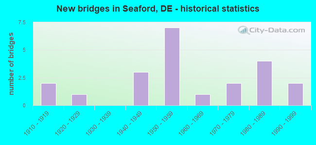
- New bridges - historical statistics
- 21910-1919
- 11920-1929
- 31940-1949
- 71950-1959
- 11960-1969
- 21970-1979
- 41980-1989
- 21990-1999
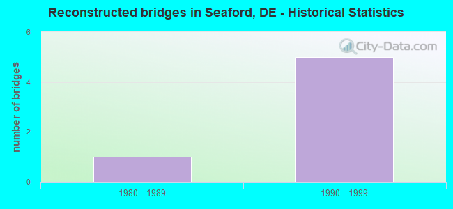
- Reconstructed bridges - Historical Statistics
- 11980-1989
- 51990-1999
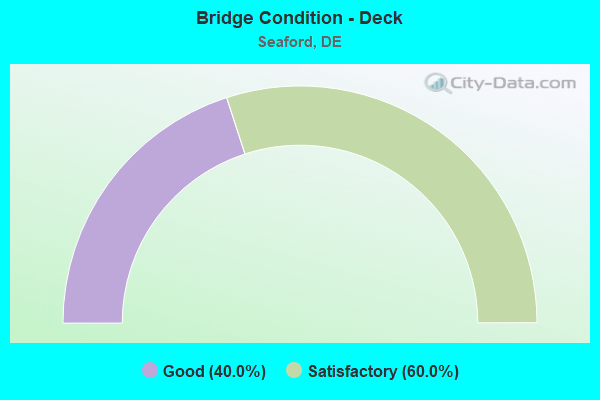
- Bridge Condition - Deck
- 40.0%Good
- 60.0%Satisfactory
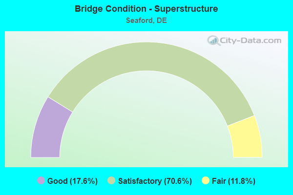
- Bridge Condition - Superstructure
- 17.6%Good
- 70.6%Satisfactory
- 11.8%Fair

- Bridge Condition - Substructure
- 64.7%Satisfactory
- 35.3%Fair
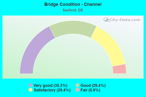
- Bridge Condition - Channel
- 35.3%Very good
- 29.4%Good
- 29.4%Satisfactory
- 5.9%Fair
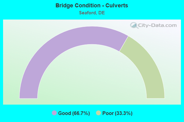
- Bridge Condition - Culverts
- 66.7%Good
- 33.3%Poor
Find on map >> Show street view
Structure Number: 3151 013, Location: SEAFORD (Lat: 38.640344, Lng: -75.609025), Route carried "on" structure: County highway 13, Year Built: 1926, Year Reconstructed: 1992, Status: Open, Structure Length: 6.15m (20.18ft), Average Daily Traffic: 13,698 (year 2019), Truck Traffic: 4%, Average Future Daily Traffic: 15,010 (year 2038), Design Load: H 20, Features Intersected: NANTICOKE RIVER, Facility Carried by Structure: FRONT ST
Minimum Vertical Clearance: 30.48m (100.00ft), Kilometerpoint: 21.530, Lanes on structure: 2, Owner: State Highway Agency, Approaching Roadway Width: 11.6m (38.1ft), Navigation Control: Yes ( Vertical Clearance: 1.0m (3.3ft), Horizontal Clearance: 12.0m (39.4ft)), Material/Design: Steel, Design/Construction: Movable - Bascule, Number Of Spans In Main Unit: 1, Number Of Approach Spans: 4, Length of Maximum Span: 14.8m (48.6ft), Curb or Sidewalk Widths: Left: 1.5m (4.9ft), Right: 1.5m (4.9ft), Curb-To-Curb Width: 7.3m (24.0ft), Out-to-Out Width: 7.6m (24.9ft)
Condition: Deck: Satisfactory, Superstructure: Satisfactory, Substructure: Satisfactory, Channel: Fair, Operating Rating: 16.5 metric tons, Method Used To Determine Operating Rating: Load and Resistance Factor Rating (LRFR) rating reported by rating factor(RF) method using HL-93 loadings, Inventory Rating: 12.6 metric tons, Method Used To Determine Inventory Rating: Load and Resistance Factor Rating (LRFR) rating reported by rating factor(RF) method using HL-93 loadings, Structural Evaluation: High priority of corrective action, Deck Geometry: High priority of replacement, Waterway Adequacy: Equal to present minimum criteria, Approach Roadway Alignment: Equal to present desirable criteria, Length Of Structure Improvement: 6.15m (20.18ft), Designated Inspection Frequency: Every 24 months, Critical Feature Inspection Frequency: Every 24 months, Underwater Inspection Frequency: Every 48 months, Inspection Date: May 2020, Critical Feature Inspection Date: May 2020, Underwater Inspection Date: March 2020, Bridge Improvement Cost: $504,000, Roadway Improvement Cost: $50,000, Total Project Cost: $756,000, Deck Structure Type: Open Grating
Find on map >> Show street view
Structure Number: 3202 013, Location: NORTH SEAFORD LIMITS (Lat: 38.679161, Lng: -75.593106), Route carried "on" structure: Alternate US 13, Year Built: 1919, Status: Open, Structure Length: 0.81m (2.66ft), Average Daily Traffic: 4,507 (year 2019), Truck Traffic: 8%, Average Future Daily Traffic: 5,601 (year 2042), Design Load: H 20, Features Intersected: CLEAR BROOK, Facility Carried by Structure: BRIDGEVILLE HGWY
Minimum Vertical Clearance: 30.48m (100.00ft), Kilometerpoint: 26.184, Lanes on structure: 2, Owner: State Highway Agency, Approaching Roadway Width: 11.8m (38.7ft), Material/Design: Concrete, Design/Construction: Arch - Deck, Number Of Spans In Main Unit: 1, Length of Maximum Span: 7.3m (24.0ft), Curb-To-Curb Width: 9.8m (32.2ft), Out-to-Out Width: 10.7m (35.1ft)
Condition: Superstructure: Good, Substructure: Satisfactory, Channel: Satisfactory, Operating Rating: 50.9 metric tons, Method Used To Determine Operating Rating: Load and Resistance Factor Rating (LRFR) rating reported by rating factor(RF) method using HL-93 loadings, Inventory Rating: 39.2 metric tons, Method Used To Determine Inventory Rating: Load and Resistance Factor Rating (LRFR) rating reported by rating factor(RF) method using HL-93 loadings, Structural Evaluation: Equal to present minimum criteria, Deck Geometry: Meets minimum limits, Waterway Adequacy: Better than present minimum criteria, Approach Roadway Alignment: Equal to present desirable criteria, Designated Inspection Frequency: Every 24 months, Underwater Inspection Frequency: Every 48 months, Inspection Date: October 2020, Underwater Inspection Date: August 2020
Find on map >> Show street view
Structure Number: 3215 536, Location: S.W. OF SEAFORD (Lat: 38.622017, Lng: -75.643697), Route carried "on" structure: County highway 536, Year Built: 1975, Status: Open, Structure Length: 1.22m (4.00ft), Average Daily Traffic: 652 (year 2019), Truck Traffic: 10%, Average Future Daily Traffic: 810 (year 2042), Design Load: HS 20, Features Intersected: BUTLER MILL BRANCH, Facility Carried by Structure: WOODLAND RD
Minimum Vertical Clearance: 30.48m (100.00ft), Kilometerpoint: 2.816, Lanes on structure: 2, Owner: State Highway Agency, Approaching Roadway Width: 11.3m (37.1ft), Material/Design: Prestressed concrete, Design/Construction: Box Beam or Girders - Multiple, Number Of Spans In Main Unit: 1, Length of Maximum Span: 10.7m (35.1ft), Curb-To-Curb Width: 11.3m (37.1ft), Out-to-Out Width: 11.9m (39.0ft)
Condition: Deck: Good, Superstructure: Satisfactory, Substructure: Satisfactory, Channel: Satisfactory, Operating Rating: 62.9 metric tons, Method Used To Determine Operating Rating: Load and Resistance Factor Rating (LRFR) rating reported by rating factor(RF) method using HL-93 loadings, Inventory Rating: 46.3 metric tons, Method Used To Determine Inventory Rating: Load and Resistance Factor Rating (LRFR) rating reported by rating factor(RF) method using HL-93 loadings, Structural Evaluation: Equal to present minimum criteria, Deck Geometry: Better than present minimum criteria, Waterway Adequacy: Better than present minimum criteria, Approach Roadway Alignment: Equal to present desirable criteria, Designated Inspection Frequency: Every 24 months, Underwater Inspection Frequency: Every 48 months, Inspection Date: September 2020, Underwater Inspection Date: June 2020, Bridge Improvement Cost: $800,000, Roadway Improvement Cost: $200,000, Total Project Cost: $1,000,000, Deck Structure Type: Concrete Cast-file-Place, Wearing Surface/Protective System: Wearing Surface: Bituminous
Find on map >> Show street view
Structure Number: 3216 536, Location: S.W. OF SEAFORD (Lat: 38.621094, Lng: -75.637550), Route carried "on" structure: County highway 536, Year Built: 1966, Status: Open, Structure Length: 1.23m (4.04ft), Average Daily Traffic: 1,274 (year 2020), Truck Traffic: 7%, Average Future Daily Traffic: 1,583 (year 2043), Design Load: HS 20, Features Intersected: CHAPEL BRANCH, Facility Carried by Structure: WOODLAND RD
Minimum Vertical Clearance: 30.48m (100.00ft), Kilometerpoint: 3.364, Lanes on structure: 2, Owner: State Highway Agency, Approaching Roadway Width: 8.4m (27.6ft), Material/Design: Prestressed concrete, Design/Construction: Box Beam or Girders - Multiple, Number Of Spans In Main Unit: 1, Length of Maximum Span: 10.7m (35.1ft), Curb-To-Curb Width: 11.3m (37.1ft), Out-to-Out Width: 12.1m (39.7ft)
Condition: Deck: Satisfactory, Superstructure: Satisfactory, Substructure: Satisfactory, Channel: Very good, Operating Rating: 66.7 metric tons, Method Used To Determine Operating Rating: Load Factor (LF), Inventory Rating: 51.0 metric tons, Method Used To Determine Inventory Rating: Load Factor (LF), Structural Evaluation: Equal to present minimum criteria, Deck Geometry: Equal to present minimum criteria, Waterway Adequacy: Better than present minimum criteria, Approach Roadway Alignment: Equal to present desirable criteria, Designated Inspection Frequency: Every 24 months, Inspection Date: June 2021, Deck Structure Type: Concrete Precast Panels, Wearing Surface/Protective System: Wearing Surface: Bituminous
Find on map >> Show street view
Structure Number: 3217 542A, Location: WEST OF SEAFORD (Lat: 38.627497, Lng: -75.646328), Route carried "on" structure: County highway 542A, Year Built: 1973, Status: Open, Structure Length: 0.73m (2.40ft), Average Daily Traffic: 302 (year 2020), Truck Traffic: 8%, Average Future Daily Traffic: 375 (year 2043), Design Load: HS 20, Features Intersected: CRAIGS POND SPILLWAY, Facility Carried by Structure: CRAIGS MILL RD
Minimum Vertical Clearance: 30.48m (100.00ft), Kilometerpoint: 0.225, Lanes on structure: 2, Owner: State Highway Agency, Approaching Roadway Width: 6.2m (20.3ft), Material/Design: Aluminum, Iron, Design/Construction: Culvert, Number Of Spans In Main Unit: 2, Length of Maximum Span: 3.1m (10.2ft)
Condition: Channel: Satisfactory, Culverts: Poor, Operating Rating: 32.7 metric tons, Method Used To Determine Operating Rating: Field evaluation and documented engineering judgment, Inventory Rating: 32.7 metric tons, Method Used To Determine Inventory Rating: Field evaluation and documented engineering judgment, Structural Evaluation: Meets minimum limits, Waterway Adequacy: Better than present minimum criteria, Approach Roadway Alignment: Equal to present desirable criteria, Designated Inspection Frequency: Every 12 months, Inspection Date: July 2021
Find on map >> Show street view
Structure Number: 3235 525, Location: N.E.OF SEAFORD (Lat: 38.687117, Lng: -75.548142), Route carried "on" structure: County highway 525, Year Built: 1983, Status: Open, Structure Length: 1.84m (6.04ft), Average Daily Traffic: 2,600 (year 2020), Truck Traffic: 13%, Average Future Daily Traffic: 3,231 (year 2043), Design Load: HS 20, Features Intersected: GRAVELLY FORK, Facility Carried by Structure: COVERDALE RD.
Minimum Vertical Clearance: 30.48m (100.00ft), Kilometerpoint: 4.170, Lanes on structure: 2, Owner: State Highway Agency, Approaching Roadway Width: 6.7m (22.0ft), Material/Design: Wood or Timber, Design/Construction: Slab, Number Of Spans In Main Unit: 3, Length of Maximum Span: 6.1m (20.0ft), Curb or Sidewalk Widths: Left: 1.2m (3.9ft), Right: 1.2m (3.9ft), Curb-To-Curb Width: 8.5m (27.9ft), Out-to-Out Width: 9.4m (30.8ft)
Condition: Deck: Good, Superstructure: Good, Substructure: Satisfactory, Channel: Satisfactory, Operating Rating: 39.2 metric tons, Method Used To Determine Operating Rating: Load and Resistance Factor Rating (LRFR) rating reported by rating factor(RF) method using HL-93 loadings, Inventory Rating: 28.5 metric tons, Method Used To Determine Inventory Rating: Load and Resistance Factor Rating (LRFR) rating reported by rating factor(RF) method using HL-93 loadings, Structural Evaluation: Equal to present minimum criteria, Deck Geometry: Meets minimum limits, Waterway Adequacy: Better than present minimum criteria, Approach Roadway Alignment: Equal to present desirable criteria, Length Of Structure Improvement: 3.05m (10.01ft), Designated Inspection Frequency: Every 24 months, Inspection Date: August 2021, Bridge Improvement Cost: $500,000, Roadway Improvement Cost: $100,000, Total Project Cost: $600,000, Deck Structure Type: Concrete Cast-file-Place, Wearing Surface/Protective System: Wearing Surface: Monolithic Concrete, Deck Protection: Epoxy Coated Reinforcing
Find on map >> Show street view
Structure Number: 3237 046, Location: EAST OF SEAFORD (Lat: 38.665561, Lng: -75.565250), Route carried "on" structure: County highway 46, Year Built: 1919, Status: Open, Structure Length: 1.71m (5.61ft), Average Daily Traffic: 5,208 (year 2019), Truck Traffic: 8%, Average Future Daily Traffic: 6,473 (year 2042), Features Intersected: NANTICOKE RIVER, Facility Carried by Structure: OLD FURNACE RD.
Minimum Vertical Clearance: 30.48m (100.00ft), Kilometerpoint: 4.860, Lanes on structure: 2, Owner: State Highway Agency, Approaching Roadway Width: 10.4m (34.1ft), Material/Design: Concrete, Design/Construction: Arch - Deck, Number Of Spans In Main Unit: 1, Length of Maximum Span: 17.1m (56.1ft), Curb-To-Curb Width: 6.2m (20.3ft), Out-to-Out Width: 6.8m (22.3ft)
Condition: Superstructure: Fair, Substructure: Fair, Channel: Very good, Operating Rating: 54.4 metric tons, Method Used To Determine Operating Rating: Field evaluation and documented engineering judgment, Inventory Rating: 32.7 metric tons, Method Used To Determine Inventory Rating: Field evaluation and documented engineering judgment, Structural Evaluation: Somewhat better than minimum adequacy, Deck Geometry: High priority of replacement, Waterway Adequacy: Better than present minimum criteria, Approach Roadway Alignment: Equal to present desirable criteria, Length Of Structure Improvement: 1.89m (6.20ft), Designated Inspection Frequency: Every 24 months, Inspection Date: September 2020, Bridge Improvement Cost: $139,000, Roadway Improvement Cost: $14,000, Total Project Cost: $208,000
Find on map >> Show street view
Structure Number: 3238 046, Location: N.E. OF SEAFORD (Lat: 38.664783, Lng: -75.563511), Route carried "on" structure: County highway 46, Year Built: 1999, Status: Open, Structure Length: 0.61m (2.00ft), Average Daily Traffic: 5,208 (year 2019), Truck Traffic: 8%, Average Future Daily Traffic: 6,473 (year 2042), Design Load: HS 25 or greater, Features Intersected: GRAVELLY FORK, Facility Carried by Structure: OLD FURNACE RD.
Minimum Vertical Clearance: 30.48m (100.00ft), Kilometerpoint: 5.020, Lanes on structure: 2, Owner: State Highway Agency, Approaching Roadway Width: 13.3m (43.6ft), Material/Design: Concrete, Design/Construction: Culvert, Number Of Spans In Main Unit: 1, Length of Maximum Span: 6.1m (20.0ft), Curb-To-Curb Width: 13.3m (43.6ft), Out-to-Out Width: 14.1m (46.3ft)
Condition: Channel: Good, Culverts: Good, Operating Rating: 50.9 metric tons, Method Used To Determine Operating Rating: Load and Resistance Factor Rating (LRFR) rating reported by rating factor(RF) method using HL-93 loadings, Inventory Rating: 39.2 metric tons, Method Used To Determine Inventory Rating: Load and Resistance Factor Rating (LRFR) rating reported by rating factor(RF) method using HL-93 loadings, Structural Evaluation: Better than present minimum criteria, Deck Geometry: Somewhat better than minimum adequacy, Waterway Adequacy: Better than present minimum criteria, Approach Roadway Alignment: Equal to present desirable criteria, Designated Inspection Frequency: Every 24 months, Inspection Date: September 2020, Bridge Improvement Cost: $800,000, Roadway Improvement Cost: $200,000, Total Project Cost: $1,000,000, Deck Structure Type: Concrete Precast Panels, Wearing Surface/Protective System: Wearing Surface: Bituminous
Find on map >> Show street view
Structure Number: 3241 534, Location: EAST OF SEAFORD (Lat: 38.656714, Lng: -75.584364), Route carried "on" structure: County highway 534, Year Built: 1994, Status: Open, Structure Length: 1.64m (5.38ft), Average Daily Traffic: 5,483 (year 2020), Truck Traffic: 8%, Average Future Daily Traffic: 6,814 (year 2043), Design Load: HS 25 or greater, Features Intersected: WILLIAMS POND, Facility Carried by Structure: THARP RD.
Minimum Vertical Clearance: 30.48m (100.00ft), Kilometerpoint: 0.740, Lanes on structure: 2, Owner: State Highway Agency, Approaching Roadway Width: 6.9m (22.6ft), Material/Design: Prestressed concrete, Design/Construction: Box Beam or Girders - Single/Spread, Number Of Spans In Main Unit: 1, Length of Maximum Span: 15.2m (49.9ft), Curb-To-Curb Width: 11.6m (38.1ft), Out-to-Out Width: 12.4m (40.7ft)
Condition: Deck: Good, Superstructure: Good, Substructure: Satisfactory, Channel: Very good, Operating Rating: 40.8 metric tons, Method Used To Determine Operating Rating: Load and Resistance Factor Rating (LRFR) rating reported by rating factor(RF) method using HL-93 loadings, Inventory Rating: 32.7 metric tons, Method Used To Determine Inventory Rating: Load and Resistance Factor Rating (LRFR) rating reported by rating factor(RF) method using HL-93 loadings, Structural Evaluation: Equal to present minimum criteria, Deck Geometry: Somewhat better than minimum adequacy, Waterway Adequacy: Equal to present minimum criteria, Approach Roadway Alignment: Equal to present minimum criteria, Designated Inspection Frequency: Every 24 months, Inspection Date: July 2021, Deck Structure Type: Concrete Cast-file-Place, Wearing Surface/Protective System: Wearing Surface: Monolithic Concrete, Deck Protection: Epoxy Coated Reinforcing
Find on map >> Show street view
Structure Number: 3242 535, Location: SEAFORD (Lat: 38.642322, Lng: -75.606653), Route carried "on" structure: County highway 535, Year Built: 1954, Status: Open, Structure Length: 4.22m (13.85ft), Average Daily Traffic: 7,099 (year 2020), Truck Traffic: 7%, Average Future Daily Traffic: 8,823 (year 2043), Design Load: HS 20, Features Intersected: TRIB. OF NANTICOKE RIVER, Facility Carried by Structure: MIDDLEFORD RD
Minimum Vertical Clearance: 30.48m (100.00ft), Kilometerpoint: 0.210, Lanes on structure: 2, Owner: State Highway Agency, Approaching Roadway Width: 12.2m (40.0ft), Material/Design: Steel, Design/Construction: Stringer/Multi-beam, Number Of Spans In Main Unit: 3, Length of Maximum Span: 13.7m (44.9ft), Curb or Sidewalk Widths: Left: 1.4m (4.6ft), Right: 1.4m (4.6ft), Curb-To-Curb Width: 12.2m (40.0ft), Out-to-Out Width: 15.8m (51.8ft)
Condition: Deck: Satisfactory, Superstructure: Fair, Substructure: Fair, Channel: Good, Operating Rating: 79.6 metric tons, Method Used To Determine Operating Rating: Load Factor (LF), Inventory Rating: 50.5 metric tons, Method Used To Determine Inventory Rating: Load Factor (LF), Structural Evaluation: Somewhat better than minimum adequacy, Deck Geometry: Somewhat better than minimum adequacy, Waterway Adequacy: Better than present minimum criteria, Approach Roadway Alignment: Equal to present desirable criteria, Designated Inspection Frequency: Every 24 months, Underwater Inspection Frequency: Every 24 months, Inspection Date: July 2021, Underwater Inspection Date: May 2021, Deck Structure Type: Concrete Cast-file-Place, Wearing Surface/Protective System: Wearing Surface: Monolithic Concrete
Find on map >> Show street view
Structure Number: 3251 524, Location: CONCORD POND (Lat: 38.643153, Lng: -75.554067), Route carried "on" structure: County highway 524, Year Built: 1980, Status: Open, Structure Length: 1.92m (6.30ft), Average Daily Traffic: 4,988 (year 2020), Truck Traffic: 8%, Average Future Daily Traffic: 6,199 (year 2043), Design Load: HS 20, Features Intersected: CONCORD POND SPILLWAY, Facility Carried by Structure: GERMAN RD
Minimum Vertical Clearance: 30.48m (100.00ft), Kilometerpoint: 0.435, Lanes on structure: 2, Owner: State Highway Agency, Approaching Roadway Width: 6.9m (22.6ft), Material/Design: Concrete continuous, Design/Construction: Slab, Number Of Spans In Main Unit: 2, Length of Maximum Span: 9.1m (29.9ft), Curb-To-Curb Width: 11.4m (37.4ft), Out-to-Out Width: 12.0m (39.4ft)
Condition: Deck: Satisfactory, Superstructure: Satisfactory, Substructure: Satisfactory, Channel: Very good, Operating Rating: 86.5 metric tons, Method Used To Determine Operating Rating: Load Factor (LF), Inventory Rating: 51.8 metric tons, Method Used To Determine Inventory Rating: Load Factor (LF), Structural Evaluation: Equal to present minimum criteria, Deck Geometry: Somewhat better than minimum adequacy, Waterway Adequacy: Equal to present minimum criteria, Approach Roadway Alignment: Equal to present desirable criteria, Designated Inspection Frequency: Every 24 months, Inspection Date: July 2021, Deck Structure Type: Concrete Cast-file-Place
Find on map >> Show street view
Structure Number: 3253N003, Location: S/E OF SEAFORD (Lat: 38.650222, Lng: -75.594058), Route carried "on" structure: US 13, Year Built: 1952, Year Reconstructed: 1996, Status: Open, Structure Length: 3.19m (10.47ft), Average Daily Traffic: 18,967 (year 2019), Truck Traffic: 9%, Average Future Daily Traffic: 23,574 (year 2042), Design Load: HS 20, Features Intersected: WILLIAMS POND
Minimum Vertical Clearance: 30.48m (100.00ft), Kilometerpoint: 1.030, Lanes on structure: 2, Base Highway Network: Yes, Owner: State Highway Agency, Approaching Roadway Width: 10.6m (34.8ft), Material/Design: Steel, Design/Construction: Stringer/Multi-beam, Number Of Spans In Main Unit: 3, Length of Maximum Span: 10.7m (35.1ft), Curb-To-Curb Width: 9.6m (31.5ft), Out-to-Out Width: 10.4m (34.1ft)
Condition: Deck: Good, Superstructure: Satisfactory, Substructure: Fair, Channel: Very good, Operating Rating: 40.2 metric tons, Method Used To Determine Operating Rating: Load and Resistance Factor Rating (LRFR) rating reported by rating factor(RF) method using HL-93 loadings, Inventory Rating: 31.1 metric tons, Method Used To Determine Inventory Rating: Load and Resistance Factor Rating (LRFR) rating reported by rating factor(RF) method using HL-93 loadings, Structural Evaluation: Somewhat better than minimum adequacy, Deck Geometry: Meets minimum limits, Waterway Adequacy: Equal to present desirable criteria, Approach Roadway Alignment: Equal to present desirable criteria, Designated Inspection Frequency: Every 24 months, Underwater Inspection Frequency: Every 48 months, Inspection Date: August 2020, Underwater Inspection Date: March 2020, Bridge Improvement Cost: $800,000, Roadway Improvement Cost: $200,000, Total Project Cost: $1,000,000, Deck Structure Type: Concrete Cast-file-Place, Wearing Surface/Protective System: Wearing Surface: Latex Concrete
Find on map >> Show street view
Structure Number: 3253S003, Location: EAST OF SEAFORD (Lat: 38.650206, Lng: -75.594322), Route carried "on" structure: US 13, Year Built: 1952, Year Reconstructed: 1996, Status: Open, Structure Length: 3.19m (10.47ft), Average Daily Traffic: 18,967 (year 2019), Truck Traffic: 9%, Average Future Daily Traffic: 23,574 (year 2042), Design Load: HS 20, Features Intersected: WILLIAMS POND
Minimum Vertical Clearance: 30.48m (100.00ft), Kilometerpoint: 1.030, Lanes on structure: 2, Base Highway Network: Yes, Owner: State Highway Agency, Approaching Roadway Width: 10.6m (34.8ft), Material/Design: Steel, Design/Construction: Stringer/Multi-beam, Number Of Spans In Main Unit: 3, Length of Maximum Span: 10.7m (35.1ft), Curb-To-Curb Width: 9.6m (31.5ft), Out-to-Out Width: 10.4m (34.1ft)
Condition: Deck: Good, Superstructure: Satisfactory, Substructure: Fair, Channel: Very good, Operating Rating: 40.2 metric tons, Method Used To Determine Operating Rating: Load and Resistance Factor Rating (LRFR) rating reported by rating factor(RF) method using HL-93 loadings, Inventory Rating: 31.1 metric tons, Method Used To Determine Inventory Rating: Load and Resistance Factor Rating (LRFR) rating reported by rating factor(RF) method using HL-93 loadings, Structural Evaluation: Somewhat better than minimum adequacy, Deck Geometry: Meets minimum limits, Waterway Adequacy: Equal to present desirable criteria, Approach Roadway Alignment: Equal to present desirable criteria, Designated Inspection Frequency: Every 24 months, Underwater Inspection Frequency: Every 48 months, Inspection Date: August 2020, Underwater Inspection Date: March 2020, Bridge Improvement Cost: $800,000, Roadway Improvement Cost: $200,000, Total Project Cost: $1,000,000, Deck Structure Type: Concrete Cast-file-Place, Wearing Surface/Protective System: Wearing Surface: Latex Concrete
Find on map >> Show street view
Structure Number: 3254N003, Location: S/W SEAFORD (Lat: 38.643286, Lng: -75.593525), Route carried "on" structure: US 13, Year Built: 1951, Year Reconstructed: 1996, Status: Open, Structure Length: 9.99m (32.78ft), Average Daily Traffic: 17,415 (year 2019), Truck Traffic: 9%, Average Future Daily Traffic: 21,645 (year 2042), Design Load: HS 20, Features Intersected: NANTICOKE RIVER
Minimum Vertical Clearance: 30.48m (100.00ft), Kilometerpoint: 0.310, Lanes on structure: 2, Base Highway Network: Yes, Owner: State Highway Agency, Approaching Roadway Width: 11.0m (36.1ft), Navigation Control: Yes ( Vertical Clearance: 3.4m (11.2ft), Horizontal Clearance: 13.7m (44.9ft)), Material/Design: Steel, Design/Construction: Stringer/Multi-beam, Number Of Spans In Main Unit: 9, Length of Maximum Span: 13.6m (44.6ft), Curb-To-Curb Width: 9.6m (31.5ft), Out-to-Out Width: 10.4m (34.1ft)
Condition: Deck: Satisfactory, Superstructure: Satisfactory, Substructure: Fair, Channel: Good, Operating Rating: 37.6 metric tons, Method Used To Determine Operating Rating: Load and Resistance Factor Rating (LRFR) rating reported by rating factor(RF) method using HL-93 loadings, Inventory Rating: 29.2 metric tons, Method Used To Determine Inventory Rating: Load and Resistance Factor Rating (LRFR) rating reported by rating factor(RF) method using HL-93 loadings, Structural Evaluation: Somewhat better than minimum adequacy, Deck Geometry: Meets minimum limits, Waterway Adequacy: Equal to present desirable criteria, Approach Roadway Alignment: Equal to present desirable criteria, Designated Inspection Frequency: Every 24 months, Underwater Inspection Frequency: Every 24 months, Inspection Date: July 2020, Underwater Inspection Date: June 2020, Bridge Improvement Cost: $800,000, Roadway Improvement Cost: $200,000, Total Project Cost: $1,000,000, Deck Structure Type: Concrete Cast-file-Place, Wearing Surface/Protective System: Wearing Surface: Monolithic Concrete
Find on map >> Show street view
Structure Number: 3254S003, Location: S/W SEAFORD (Lat: 38.643272, Lng: -75.593794), Route carried "on" structure: US 13, Year Built: 1951, Year Reconstructed: 1996, Status: Open, Structure Length: 9.99m (32.78ft), Average Daily Traffic: 17,415 (year 2019), Truck Traffic: 7%, Average Future Daily Traffic: 21,645 (year 2042), Design Load: HS 20, Features Intersected: NANTICOKE RIVER
Minimum Vertical Clearance: 30.48m (100.00ft), Kilometerpoint: 0.306, Lanes on structure: 2, Base Highway Network: Yes, Owner: State Highway Agency, Approaching Roadway Width: 11.0m (36.1ft), Navigation Control: Yes ( Vertical Clearance: 3.4m (11.2ft), Horizontal Clearance: 13.7m (44.9ft)), Material/Design: Steel, Design/Construction: Stringer/Multi-beam, Number Of Spans In Main Unit: 9, Length of Maximum Span: 13.6m (44.6ft), Curb-To-Curb Width: 9.6m (31.5ft), Out-to-Out Width: 10.4m (34.1ft)
Condition: Deck: Satisfactory, Superstructure: Satisfactory, Substructure: Fair, Channel: Good, Operating Rating: 37.6 metric tons, Method Used To Determine Operating Rating: Load and Resistance Factor Rating (LRFR) rating reported by rating factor(RF) method using HL-93 loadings, Inventory Rating: 29.2 metric tons, Method Used To Determine Inventory Rating: Load and Resistance Factor Rating (LRFR) rating reported by rating factor(RF) method using HL-93 loadings, Structural Evaluation: Somewhat better than minimum adequacy, Deck Geometry: Meets minimum limits, Waterway Adequacy: Equal to present desirable criteria, Approach Roadway Alignment: Equal to present desirable criteria, Designated Inspection Frequency: Every 24 months, Underwater Inspection Frequency: Every 24 months, Inspection Date: July 2020, Underwater Inspection Date: June 2020, Bridge Improvement Cost: $800,000, Roadway Improvement Cost: $200,000, Total Project Cost: $1,000,000, Deck Structure Type: Concrete Cast-file-Place, Wearing Surface/Protective System: Wearing Surface: Monolithic Concrete
Find on map >> Show street view
Structure Number: 3255 003, Location: NORTH OF SEAFORD (Lat: 38.678794, Lng: -75.591606), Route carried "on" structure: US 13, Year Built: 1952, Status: Open, Structure Length: 0.98m (3.22ft), Average Daily Traffic: 18,153 (year 2020), Truck Traffic: 7%, Average Future Daily Traffic: 22,562 (year 2043), Design Load: HS 20, Features Intersected: CLEAR BROOK
Minimum Vertical Clearance: 30.48m (100.00ft), Kilometerpoint: 4.240, Lanes on structure: 4, Base Highway Network: Yes, Owner: State Highway Agency, Approaching Roadway Width: 11.6m (38.1ft), Skew: 20 degrees, Material/Design: Concrete, Design/Construction: Culvert, Number Of Spans In Main Unit: 3, Length of Maximum Span: 3.0m (9.8ft)
Condition: Channel: Satisfactory, Culverts: Good, Operating Rating: 46.7 metric tons, Method Used To Determine Operating Rating: Load and Resistance Factor Rating (LRFR) rating reported by rating factor(RF) method using HL-93 loadings, Inventory Rating: 36.0 metric tons, Method Used To Determine Inventory Rating: Load and Resistance Factor Rating (LRFR) rating reported by rating factor(RF) method using HL-93 loadings, Structural Evaluation: Better than present minimum criteria, Waterway Adequacy: Equal to present minimum criteria, Approach Roadway Alignment: Equal to present desirable criteria, Designated Inspection Frequency: Every 24 months, Inspection Date: August 2021
Find on map >> Show street view
Structure Number: 3256 535B, Location: SEAFORD (Lat: 38.642958, Lng: -75.605511), Route carried "on" structure: County highway 535B, Year Built: 1954, Status: Open, Structure Length: 2.32m (7.61ft), Average Daily Traffic: 928 (year 2020), Truck Traffic: 8%, Average Future Daily Traffic: 1,153 (year 2043), Design Load: H 20, Features Intersected: WILLIAMS POND
Minimum Vertical Clearance: 30.48m (100.00ft), Kilometerpoint: 0.032, Lanes on structure: 2, Owner: State Highway Agency, Approaching Roadway Width: 10.7m (35.1ft), Material/Design: Steel, Design/Construction: Stringer/Multi-beam, Number Of Spans In Main Unit: 2, Length of Maximum Span: 11.0m (36.1ft), Curb or Sidewalk Widths: Left: 0.0m, Right: 0.9m (3.0ft), Curb-To-Curb Width: 7.3m (24.0ft), Out-to-Out Width: 9.0m (29.5ft)
Condition: Deck: Satisfactory, Superstructure: Satisfactory, Substructure: Satisfactory, Channel: Good, Operating Rating: 64.3 metric tons, Method Used To Determine Operating Rating: Load Factor (LF), Inventory Rating: 40.5 metric tons, Method Used To Determine Inventory Rating: Load Factor (LF), Structural Evaluation: Equal to present minimum criteria, Deck Geometry: Meets minimum limits, Waterway Adequacy: Better than present minimum criteria, Approach Roadway Alignment: Equal to present desirable criteria, Designated Inspection Frequency: Every 24 months, Inspection Date: July 2021, Deck Structure Type: Concrete Cast-file-Place, Wearing Surface/Protective System: Wearing Surface: Monolithic Concrete
Find on map >> Show street view
Structure Number: 3257E021, Location: SEAFORD (Lat: 38.646381, Lng: -75.618050), Route carried "on" structure: State highway 20, Year Built: 1940, Year Reconstructed: 1996, Status: Open, Structure Length: 17.07m (56.00ft), Average Daily Traffic: 6,968 (year 2020), Truck Traffic: 7%, Average Future Daily Traffic: 8,660 (year 2043), Design Load: H 20, Features Intersected: NORFOLK SOUTHERN
Minimum Vertical Clearance: 30.48m (100.00ft), Kilometerpoint: 7.982, Lanes on structure: 2, Lanes under structure: 2, Owner: State Highway Agency, Approaching Roadway Width: 9.0m (29.5ft), Skew: 1 degrees, Material/Design: Steel, Design/Construction: Stringer/Multi-beam, Number Of Spans In Main Unit: 1, Number Of Approach Spans: 20, Length of Maximum Span: 12.2m (40.0ft), Curb or Sidewalk Widths: Left: 1.5m (4.9ft), Right: 1.5m (4.9ft), Curb-To-Curb Width: 9.0m (29.5ft), Out-to-Out Width: 12.9m (42.3ft)
Condition: Deck: Satisfactory, Superstructure: Satisfactory, Substructure: Satisfactory, Operating Rating: 72.4 metric tons, Method Used To Determine Operating Rating: Load Factor (LF), Inventory Rating: 41.1 metric tons, Method Used To Determine Inventory Rating: Load Factor (LF), Structural Evaluation: Equal to present minimum criteria, Deck Geometry: High priority of corrective action, Underclear: Meets minimum limits, Approach Roadway Alignment: Equal to present desirable criteria, Length Of Structure Improvement: 17.07m (56.00ft), Designated Inspection Frequency: Every 24 months, Inspection Date: July 2021, Bridge Improvement Cost: $2,374,000, Roadway Improvement Cost: $237,000, Total Project Cost: $3,562,000, Deck Structure Type: Concrete Cast-file-Place, Wearing Surface/Protective System: Wearing Surface: Latex Concrete
Find on map >> Show street view
Structure Number: 3257W021, Location: SEAFORD (Lat: 38.646492, Lng: -75.618106), Route carried "on" structure: State highway 20, Year Built: 1985, Status: Open, Structure Length: 7.47m (24.51ft), Average Daily Traffic: 6,968 (year 2020), Truck Traffic: 7%, Average Future Daily Traffic: 8,660 (year 2043), Design Load: HS 20, Features Intersected: NORFOLK SOUTHERN
Minimum Vertical Clearance: 30.48m (100.00ft), Kilometerpoint: 7.982, Lanes on structure: 2, Lanes under structure: 2, Owner: State Highway Agency, Approaching Roadway Width: 8.5m (27.9ft), Skew: 1 degrees, Material/Design: Steel continuous, Design/Construction: Stringer/Multi-beam, Number Of Spans In Main Unit: 3, Length of Maximum Span: 27.4m (89.9ft), Curb or Sidewalk Widths: Left: 0.0m, Right: 2.2m (7.2ft), Curb-To-Curb Width: 8.5m (27.9ft), Out-to-Out Width: 11.5m (37.7ft)
Condition: Deck: Good, Superstructure: Satisfactory, Substructure: Satisfactory, Operating Rating: 49.9 metric tons, Method Used To Determine Operating Rating: Load and Resistance Factor Rating (LRFR) rating reported by rating factor(RF) method using HL-93 loadings, Inventory Rating: 38.2 metric tons, Method Used To Determine Inventory Rating: Load and Resistance Factor Rating (LRFR) rating reported by rating factor(RF) method using HL-93 loadings, Structural Evaluation: Equal to present minimum criteria, Deck Geometry: High priority of corrective action, Underclear: Meets minimum limits, Approach Roadway Alignment: Equal to present desirable criteria, Length Of Structure Improvement: 7.47m (24.51ft), Designated Inspection Frequency: Every 24 months, Inspection Date: July 2021, Bridge Improvement Cost: $923,000, Roadway Improvement Cost: $92,000, Total Project Cost: $1,384,000, Deck Structure Type: Concrete Cast-file-Place, Wearing Surface/Protective System: Wearing Surface: Monolithic Concrete, Deck Protection: Epoxy Coated Reinforcing
Find on map >> Show street view
Structure Number: 3258 536, Location: SEAFORD (Lat: 38.639844, Lng: -75.614975), Route carried "on" structure: County highway 536, Year Built: 1941, Status: Open, Structure Length: 3.10m (10.17ft), Average Daily Traffic: 7,127 (year 2019), Truck Traffic: 6%, Average Future Daily Traffic: 8,858 (year 2042), Design Load: HS 20, Features Intersected: NORFOLK SOUTHERN, Facility Carried by Structure: HIGH ST
Minimum Vertical Clearance: 30.48m (100.00ft), Kilometerpoint: 7.400, Lanes on structure: 2, Owner: State Highway Agency, Approaching Roadway Width: 11.0m (36.1ft), Material/Design: Concrete continuous, Design/Construction: Slab, Number Of Spans In Main Unit: 3, Length of Maximum Span: 15.8m (51.8ft), Curb or Sidewalk Widths: Left: 1.5m (4.9ft), Right: 1.5m (4.9ft), Curb-To-Curb Width: 12.8m (42.0ft), Out-to-Out Width: 16.8m (55.1ft)
Condition: Deck: Satisfactory, Superstructure: Satisfactory, Substructure: Satisfactory, Operating Rating: 81.1 metric tons, Method Used To Determine Operating Rating: Load Factor (LF), Inventory Rating: 48.4 metric tons, Method Used To Determine Inventory Rating: Load Factor (LF), Structural Evaluation: Equal to present minimum criteria, Deck Geometry: Somewhat better than minimum adequacy, Underclear: Meets minimum limits, Approach Roadway Alignment: Equal to present desirable criteria, Designated Inspection Frequency: Every 24 months, Inspection Date: October 2020, Bridge Improvement Cost: $800,000, Roadway Improvement Cost: $200,000, Total Project Cost: $1,000,000, Deck Structure Type: Concrete Cast-file-Place, Wearing Surface/Protective System: Wearing Surface: Latex Concrete
Find on map >> Show street view
Structure Number: 3257E021, Location: SEAFORD (Lat: 38.646381, Lng: -75.618050), Route carried "under" structure: City street , Year Built: 1940, Structure Length: 0. m, Average Daily Traffic: 99 (year 2020), Truck Traffic: 11%, Features Intersected: NORFOLK SOUTHERN, Facility Carried by Structure: STEIN HWY/SR20
Minimum Vertical Clearance: 5.53m (18.14ft), Kilometerpoint: 0.500, Lanes on structure: 2, Lanes under structure: 2, Material/Design: Steel, Design/Construction: Stringer/Multi-beam, Length of Maximum Span: 12.2m (40.0ft)
Find on map >> Show street view
Structure Number: 3257W021, Location: SEAFORD (Lat: 38.646492, Lng: -75.618106), Route carried "under" structure: City street , Year Built: 1985, Structure Length: 0. m, Average Daily Traffic: 99 (year 2020), Truck Traffic: 9%, Features Intersected: NORFOLK SOUTHERN, Facility Carried by Structure: STEIN HWY/SR20
Minimum Vertical Clearance: 6.04m (19.82ft), Kilometerpoint: 0.500, Lanes on structure: 2, Lanes under structure: 2, Material/Design: Steel continuous, Design/Construction: Stringer/Multi-beam, Length of Maximum Span: 27.4m (89.9ft)