Bridge Statistics for Scotts Valley, California (CA)
Condition, Traffic, Stress, Structural Evaluation, Project Costs
- National Bridge Inventory (NBI) Statistics
- 12Number of bridges
- 121ft / 37.3mTotal length
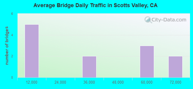
- 366,000Total average daily traffic
- 14,310Total average daily truck traffic
- National Bridge Inventory (NBI) Registered Bridges for Scotts Valley
- No street view available for this location
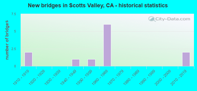
- New bridges - historical statistics
- 21910-1919
- 11940-1949
- 11950-1959
- 61960-1969
- 22010-2019
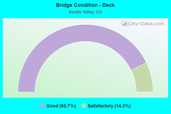
- Bridge Condition - Deck
- 85.7%Good
- 14.3%Satisfactory
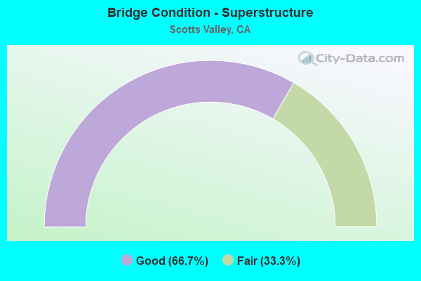
- Bridge Condition - Superstructure
- 66.7%Good
- 33.3%Fair
Find on map >> Show street view
Structure Number: 36 0058, Location: 05-SCR-017-5.45-SCTV (Lat: 37.061328, Lng: -122.004911), Route carried "on" structure: City street , Year Built: 1961, Status: Open, Structure Length: 7.84m (25.72ft), Average Daily Traffic: 10,900 (year 2018), Truck Traffic: 1%, Average Future Daily Traffic: 8,439 (year 2038), Design Load: HS 20+Mod, Features Intersected: STATE ROUTE 17, Facility Carried by Structure: GRANITE CREEK ROAD
Minimum Vertical Clearance: 30+ m (98+ ft), Kilometerpoint: 0.000, Lanes on structure: 2, Lanes under structure: 6, Owner: State Highway Agency, Approaching Roadway Width: 12.2m (40.0ft), Skew: 1 degrees, Material/Design: Concrete continuous, Design/Construction: Box Beam or Girders - Multiple, Number Of Spans In Main Unit: 4, Length of Maximum Span: 24.7m (81.0ft), Curb or Sidewalk Widths: Left: 0.0m, Right: 1.5m (4.9ft), Curb-To-Curb Width: 9.8m (32.2ft), Out-to-Out Width: 12.4m (40.7ft)
Condition: Deck: Satisfactory, Superstructure: Fair, Substructure: Good, Operating Rating: 43.4 metric tons, Method Used To Determine Operating Rating: Load and Resistance Factor Rating (LRFR) rating reported by rating factor(RF) method using HL-93 loadings, Inventory Rating: 33.0 metric tons, Method Used To Determine Inventory Rating: Load and Resistance Factor Rating (LRFR) rating reported by rating factor(RF) method using HL-93 loadings, Structural Evaluation: Somewhat better than minimum adequacy, Deck Geometry: Meets minimum limits, Underclear: High priority of corrective action, Approach Roadway Alignment: Equal to present minimum criteria, Designated Inspection Frequency: Every 24 months, Inspection Date: May 2020, Deck Structure Type: Concrete Cast-file-Place
Find on map >> Show street view
Structure Number: 36 0067, Location: 05-SCR-017-3.56-SCTV (Lat: 37.036581, Lng: -122.019364), Route carried "on" structure: State highway 17, Year Built: 1961, Status: Open, Structure Length: 3.81m (12.50ft), Average Daily Traffic: 56,000 (year 2009), Truck Traffic: 5%, Average Future Daily Traffic: 94,684 (year 2036), Design Load: HS 20, Features Intersected: GLEN CANYON ROAD
Minimum Vertical Clearance: 30+ m (98+ ft), Kilometerpoint: 3.560, Lanes on structure: 4, Lanes under structure: 2, Base Highway Network: Yes (, Subroute: 1), Owner: State Highway Agency, Approaching Roadway Width: 26.2m (86.0ft), Skew: 39 degrees, Material/Design: Concrete continuous, Design/Construction: Tee Beam, Number Of Spans In Main Unit: 3, Length of Maximum Span: 12.2m (40.0ft), Curb-To-Curb Width: 22.6m (74.1ft), Out-to-Out Width: 27.0m (88.6ft)
Condition: Deck: Good, Superstructure: Good, Substructure: Good, Operating Rating: 48.3 metric tons, Method Used To Determine Operating Rating: Load and Resistance Factor Rating (LRFR) rating reported by rating factor(RF) method using HL-93 loadings, Inventory Rating: 37.3 metric tons, Method Used To Determine Inventory Rating: Load and Resistance Factor Rating (LRFR) rating reported by rating factor(RF) method using HL-93 loadings, Structural Evaluation: Better than present minimum criteria, Deck Geometry: Superior to present desirable criteria, Underclear: High priority of corrective action, Approach Roadway Alignment: Equal to present desirable criteria, Designated Inspection Frequency: Every 48 months, Inspection Date: May 2018, Deck Structure Type: Concrete Cast-file-Place, Wearing Surface/Protective System: Wearing Surface: Bituminous
Find on map >> Show street view
Structure Number: 36 0070L, Location: 05-SCR-001-17.24-SCR (Lat: 36.985978, Lng: -122.024322), Route carried "on" structure: State highway 1, Year Built: 1956, Status: Open, Structure Length: 3.80m (12.47ft), Average Daily Traffic: 30,000 (year 2017), Truck Traffic: 4%, Average Future Daily Traffic: 49,510 (year 2039), Design Load: HS 20, Features Intersected: OCEAN STREET
Minimum Vertical Clearance: 30+ m (98+ ft), Kilometerpoint: 17.240, Lanes on structure: 2, Lanes under structure: 2, Base Highway Network: Yes (, Subroute: 1), Owner: State Highway Agency, Approaching Roadway Width: 10.7m (35.1ft), Material/Design: Prestressed concrete, Design/Construction: Stringer/Multi-beam, Number Of Spans In Main Unit: 1, Number Of Approach Spans: 2, Length of Maximum Span: 15.6m (51.2ft), Curb-To-Curb Width: 9.3m (30.5ft), Out-to-Out Width: 10.1m (33.1ft)
Condition: Deck: Good, Superstructure: Good, Substructure: Good, Operating Rating: 21.7 metric tons, Method Used To Determine Operating Rating: Load and Resistance Factor Rating (LRFR) rating reported by rating factor(RF) method using HL-93 loadings, Inventory Rating: 9.4 metric tons, Method Used To Determine Inventory Rating: Load and Resistance Factor Rating (LRFR) rating reported by rating factor(RF) method using HL-93 loadings, Structural Evaluation: High priority of corrective action, Deck Geometry: High priority of replacement, Underclear: High priority of corrective action, Approach Roadway Alignment: Equal to present minimum criteria, Designated Inspection Frequency: Every 24 months, Inspection Date: July 2021, Deck Structure Type: Concrete Cast-file-Place
Find on map >> Show street view
Structure Number: 36 0077, Location: 05-SCR-017-3.44-SCTV (Lat: 37.035903, Lng: -122.021400), Route carried "on" structure: City street E172, Year Built: 1961, Status: Open, Structure Length: 7.07m (23.20ft), Average Daily Traffic: 32,000 (year 2016), Truck Traffic: 2%, Average Future Daily Traffic: 41,408 (year 2038), Design Load: HS 20+Mod, Features Intersected: STATE ROUTE 17, Facility Carried by Structure: MOUNT HERMON ROAD
Minimum Vertical Clearance: 30+ m (98+ ft), Kilometerpoint: 0.000, Lanes on structure: 2, Lanes under structure: 4, Owner: State Highway Agency, Approaching Roadway Width: 12.2m (40.0ft), Skew: 1 degrees, Material/Design: Concrete continuous, Design/Construction: Box Beam or Girders - Multiple, Number Of Spans In Main Unit: 4, Length of Maximum Span: 22.3m (73.2ft), Curb or Sidewalk Widths: Left: 0.0m, Right: 1.5m (4.9ft), Curb-To-Curb Width: 9.7m (31.8ft), Out-to-Out Width: 12.1m (39.7ft)
Condition: Deck: Good, Superstructure: Fair, Substructure: Good, Operating Rating: 55.1 metric tons, Method Used To Determine Operating Rating: Load and Resistance Factor Rating (LRFR) rating reported by rating factor(RF) method using HL-93 loadings, Inventory Rating: 42.1 metric tons, Method Used To Determine Inventory Rating: Load and Resistance Factor Rating (LRFR) rating reported by rating factor(RF) method using HL-93 loadings, Structural Evaluation: Somewhat better than minimum adequacy, Deck Geometry: Meets minimum limits, Underclear: Meets minimum limits, Approach Roadway Alignment: Somewhat better than minimum adequacy, Designated Inspection Frequency: Every 24 months, Inspection Date: May 2020, Deck Structure Type: Concrete Cast-file-Place
Find on map >> Show street view
Structure Number: 36 012, Location: 05-SCR-017-8.60 (Lat: 37.093722, Lng: -121.977972), Route carried "on" structure: State highway 17, Year Built: 2018, Status: Open, Structure Length: 6.45m (21.16ft), Average Daily Traffic: 61,000 (year 2016), Truck Traffic: 3%, Average Future Daily Traffic: 77,533 (year 2042), Design Load: HL 93, Features Intersected: HILLSIDE
Minimum Vertical Clearance: 30+ m (98+ ft), Kilometerpoint: 8.600, Lanes on structure: 4, Base Highway Network: Yes (, Subroute: 1), Owner: State Highway Agency, Approaching Roadway Width: 16.1m (52.8ft), Material/Design: Concrete continuous, Design/Construction: Slab, Number Of Spans In Main Unit: 7, Length of Maximum Span: 9.8m (32.2ft), Curb-To-Curb Width: 17.1m (56.1ft), Out-to-Out Width: 2.9m (9.5ft)
Condition: Deck: Good, Superstructure: Good, Substructure: Good, Operating Rating: 42.1 metric tons, Method Used To Determine Operating Rating: Assigned ratings based on Load and Resistance Factor Design (LRFD) reported by rating factor (RF) using HL93 loadings, Inventory Rating: 32.4 metric tons, Method Used To Determine Inventory Rating: Assigned ratings based on Load and Resistance Factor Design (LRFD) reported by rating factor (RF) using HL93 loadings, Structural Evaluation: Better than present minimum criteria, Deck Geometry: Somewhat better than minimum adequacy, Approach Roadway Alignment: Equal to present desirable criteria, Designated Inspection Frequency: Every 48 months, Inspection Date: May 2020, Deck Structure Type: Concrete Cast-file-Place, Wearing Surface/Protective System: Wearing Surface: Bituminous
Find on map >> Show street view
Structure Number: 36 0121, Location: 05-SCR-017-9.01 (Lat: 37.099194, Lng: -121.976139), Route carried "on" structure: State highway 17, Year Built: 2018, Status: Open, Structure Length: 6.00m (19.69ft), Average Daily Traffic: 61,000 (year 2016), Truck Traffic: 3%, Average Future Daily Traffic: 77,533 (year 2042), Design Load: HL 93, Features Intersected: HILLSIDE
Minimum Vertical Clearance: 30+ m (98+ ft), Kilometerpoint: 9.010, Lanes on structure: 4, Base Highway Network: Yes (, Subroute: 1), Owner: State Highway Agency, Approaching Roadway Width: 16.1m (52.8ft), Material/Design: Concrete continuous, Design/Construction: Slab, Number Of Spans In Main Unit: 6, Length of Maximum Span: 10.4m (34.1ft), Curb-To-Curb Width: 17.1m (56.1ft), Out-to-Out Width: 2.9m (9.5ft)
Condition: Deck: Good, Superstructure: Good, Substructure: Good, Operating Rating: 42.1 metric tons, Method Used To Determine Operating Rating: Assigned ratings based on Load and Resistance Factor Design (LRFD) reported by rating factor (RF) using HL93 loadings, Inventory Rating: 32.4 metric tons, Method Used To Determine Inventory Rating: Assigned ratings based on Load and Resistance Factor Design (LRFD) reported by rating factor (RF) using HL93 loadings, Structural Evaluation: Better than present minimum criteria, Deck Geometry: Somewhat better than minimum adequacy, Approach Roadway Alignment: Equal to present desirable criteria, Designated Inspection Frequency: Every 48 months, Inspection Date: May 2020, Deck Structure Type: Concrete Cast-file-Place, Wearing Surface/Protective System: Wearing Surface: Bituminous
Find on map >> Show street view
Structure Number: 36C0005, Location: 0.5 MI FROM MT HERMON RD (Lat: 37.056489, Lng: -122.032619), Route carried "on" structure: County highway , Year Built: 1940, Status: Open, Structure Length: 1.01m (3.31ft), Average Daily Traffic: 1,500 (year 2016), Truck Traffic: 10%, Average Future Daily Traffic: 1,571 (year 2043), Features Intersected: BEAN CREEK, Facility Carried by Structure: LOCKHART GULCH RD
Minimum Vertical Clearance: 30+ m (98+ ft), Kilometerpoint: 0.000, Lanes on structure: 2, Owner: County Highway Agency, Approaching Roadway Width: 7.0m (23.0ft), Skew: 2 degrees, Material/Design: Concrete, Design/Construction: Slab, Number Of Spans In Main Unit: 1, Length of Maximum Span: 10.1m (33.1ft), Curb or Sidewalk Widths: Left: 0.9m (3.0ft), Right: 0.9m (3.0ft), Curb-To-Curb Width: 7.3m (24.0ft), Out-to-Out Width: 9.1m (29.9ft)
Condition: Deck: Good, Superstructure: Good, Substructure: Good, Channel: Satisfactory, Operating Rating: 38.2 metric tons, Method Used To Determine Operating Rating: Load and Resistance Factor Rating (LRFR) rating reported by rating factor(RF) method using HL-93 loadings, Inventory Rating: 29.5 metric tons, Method Used To Determine Inventory Rating: Load and Resistance Factor Rating (LRFR) rating reported by rating factor(RF) method using HL-93 loadings, Structural Evaluation: Better than present minimum criteria, Deck Geometry: Meets minimum limits, Waterway Adequacy: Better than present minimum criteria, Approach Roadway Alignment: Equal to present minimum criteria, Designated Inspection Frequency: Every 24 months, Inspection Date: October 2021, Deck Structure Type: Concrete Cast-file-Place, Wearing Surface/Protective System: Wearing Surface: Bituminous
Find on map >> Show street view
Structure Number: 36C0047, Location: 0.5 MI N BEAN CREEK RD (Lat: 37.092744, Lng: -122.005008), Route carried "on" structure: County highway , Year Built: 1915, Status: Open, Structure Length: 0.67m (2.20ft), Average Daily Traffic: 1,000 (year 2013), Truck Traffic: 10%, Average Future Daily Traffic: 1,020 (year 2041), Features Intersected: BEAN CREEK, Facility Carried by Structure: GLENWOOD DR
Minimum Vertical Clearance: 30+ m (98+ ft), Kilometerpoint: 0.000, Lanes on structure: 2, Owner: County Highway Agency, Approaching Roadway Width: 5.5m (18.0ft), Skew: 4 degrees, Material/Design: Concrete, Design/Construction: Arch - Deck, Number Of Spans In Main Unit: 1, Length of Maximum Span: 6.7m (22.0ft)
Condition: Superstructure: Fair, Substructure: Good, Channel: Satisfactory, Operating Rating: 28.5 metric tons, Method Used To Determine Operating Rating: Field evaluation and documented engineering judgment, Inventory Rating: 17.2 metric tons, Method Used To Determine Inventory Rating: Field evaluation and documented engineering judgment, Structural Evaluation: Meets minimum limits, Waterway Adequacy: Better than present minimum criteria, Approach Roadway Alignment: Equal to present minimum criteria, Designated Inspection Frequency: Every 24 months, Inspection Date: October 2021
Find on map >> Show street view
Structure Number: 36C0048, Location: 2.3 MI N SCOTTS VLY DR (Lat: 37.097633, Lng: -121.997117), Route carried "on" structure: County highway , Year Built: 1915, Status: Open, Structure Length: 0.61m (2.00ft), Average Daily Traffic: 500 (year 2013), Truck Traffic: 10%, Average Future Daily Traffic: 510 (year 2041), Features Intersected: BEAN CREEK, Facility Carried by Structure: GLENWOOD DR
Minimum Vertical Clearance: 30+ m (98+ ft), Kilometerpoint: 0.000, Lanes on structure: 2, Owner: County Highway Agency, Approaching Roadway Width: 7.3m (24.0ft), Material/Design: Concrete, Design/Construction: Arch - Deck, Number Of Spans In Main Unit: 1, Length of Maximum Span: 6.1m (20.0ft), Curb-To-Curb Width: 7.3m (24.0ft), Out-to-Out Width: 8.5m (27.9ft)
Condition: Superstructure: Good, Substructure: Good, Channel: Satisfactory, Operating Rating: 28.2 metric tons, Method Used To Determine Operating Rating: Field evaluation and documented engineering judgment, Inventory Rating: 16.8 metric tons, Method Used To Determine Inventory Rating: Field evaluation and documented engineering judgment, Structural Evaluation: Somewhat better than minimum adequacy, Deck Geometry: Meets minimum limits, Waterway Adequacy: Equal to present minimum criteria, Approach Roadway Alignment: Equal to present desirable criteria, Designated Inspection Frequency: Every 24 months, Inspection Date: October 2021
Find on map >> Show street view
Structure Number: 36 0058, Location: 05-SCR-017-5.45-SCTV (Lat: 37.061328, Lng: -122.004911), Route carried "under" structure: State highway 17, Year Built: 1961, Structure Length: 0. m, Average Daily Traffic: 56,000 (year 2009), Truck Traffic: 5%, Features Intersected: STATE ROUTE 17, Facility Carried by Structure: GRANITE CREEK ROAD
Minimum Vertical Clearance: 4.50m (14.76ft), Kilometerpoint: 5.450, Lanes on structure: 2, Lanes under structure: 6, Material/Design: Concrete continuous, Design/Construction: Box Beam or Girders - Multiple, Length of Maximum Span: 24.7m (81.0ft)
Find on map >> Show street view
Structure Number: 36 0067, Location: 05-SCR-017-3.56-SCTV (Lat: 37.036581, Lng: -122.019364), Route carried "under" structure: City street E165, Year Built: 1961, Structure Length: 0. m, Average Daily Traffic: 100 (year 2011), Truck Traffic: 1%, Features Intersected: GLEN CANYON ROAD, Facility Carried by Structure: STATE ROUTE 17
Minimum Vertical Clearance: 6.14m (20.14ft), Kilometerpoint: 0.000, Lanes on structure: 4, Lanes under structure: 2, Material/Design: Concrete continuous, Design/Construction: Tee Beam, Length of Maximum Span: 12.2m (40.0ft)
Find on map >> Show street view
Structure Number: 36 0077, Location: 05-SCR-017-3.44-SCTV (Lat: 37.035903, Lng: -122.021400), Route carried "under" structure: State highway 17, Year Built: 1961, Structure Length: 0. m, Average Daily Traffic: 56,000 (year 2009), Truck Traffic: 5%, Features Intersected: STATE ROUTE 17, Facility Carried by Structure: MOUNT HERMON ROAD
Minimum Vertical Clearance: 4.72m (15.49ft), Kilometerpoint: 3.440, Lanes on structure: 2, Lanes under structure: 4, Material/Design: Concrete continuous, Design/Construction: Box Beam or Girders - Multiple, Length of Maximum Span: 22.3m (73.2ft)