Bridge Statistics for Schubert, Pennsylvania (PA)
Condition, Traffic, Stress, Structural Evaluation, Project Costs
- National Bridge Inventory (NBI) Statistics
- 11Number of bridges
- 39ft / 12.4mTotal length
- $617,000Total costs
- 137,672Total average daily traffic
- 47,002Total average daily truck traffic
- National Bridge Inventory (NBI) Registered Bridges for Schubert
- No street view available for this location
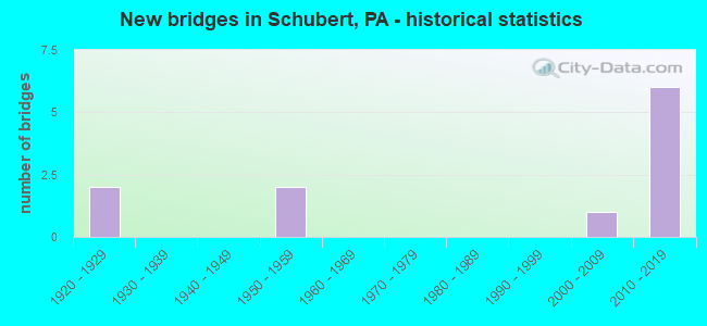
- New bridges - historical statistics
- 21920-1929
- 21950-1959
- 12000-2009
- 62010-2019


- Bridge Condition - Deck
- 20.0%Very good
- 20.0%Good
- 40.0%Satisfactory
- 20.0%Fair

- Bridge Condition - Superstructure
- 33.3%Very good
- 33.3%Satisfactory
- 16.7%Fair
- 16.7%Poor

- Bridge Condition - Substructure
- 33.3%Very good
- 66.7%Fair

- Bridge Condition - Channel
- 80.0%Fair
- 20.0%Poor
Find on map >> Show street view
Structure Number: 4634, Location: .1MI.E.OF EXIT 16(5) (Lat: 40.487014, Lng: -76.241325), Route carried "on" structure: Interstate 78, Year Built: 1950, Year Reconstructed: 1977, Status: Open, Structure Length: 0.82m (2.69ft), Average Daily Traffic: 39,239 (year 2021), Truck Traffic: 37%, Average Future Daily Traffic: 44,925 (year 2032), Design Load: HS 20+Mod, Features Intersected: TRIB. LITTLE SWATARA CRK
Minimum Vertical Clearance: 30+ m (98+ ft), Kilometerpoint: 11.496, Lanes on structure: 6, Base Highway Network: Yes, Owner: State Highway Agency, Approaching Roadway Width: 35.7m (117.1ft), Skew: 30 degrees, Material/Design: Concrete, Design/Construction: Tee Beam, Number Of Spans In Main Unit: 1, Length of Maximum Span: 7.6m (24.9ft), Curb-To-Curb Width: 35.8m (117.5ft), Out-to-Out Width: 36.8m (120.7ft)
Condition: Deck: Satisfactory, Superstructure: Satisfactory, Substructure: Fair, Channel: Fair, Operating Rating: 57.2 metric tons, Method Used To Determine Operating Rating: Load Factor (LF), Inventory Rating: 34.5 metric tons, Method Used To Determine Inventory Rating: Load Factor (LF), Structural Evaluation: Somewhat better than minimum adequacy, Deck Geometry: Superior to present desirable criteria, Waterway Adequacy: Equal to present minimum criteria, Approach Roadway Alignment: Equal to present desirable criteria, Length Of Structure Improvement: 1.40m (4.59ft), Designated Inspection Frequency: Every 24 months, Inspection Date: March 2021, Deck Structure Type: Concrete Cast-file-Place, Wearing Surface/Protective System: Wearing Surface: Latex Concrete
Find on map >> Show street view
Structure Number: 4819, Location: 2 MI.N.OF REHRERSBURG (Lat: 40.475203, Lng: -76.229156), Route carried "on" structure: State highway 419, Year Built: 1928, Status: Open, Structure Length: 1.31m (4.30ft), Average Daily Traffic: 2,661 (year 2020), Truck Traffic: 16%, Average Future Daily Traffic: 3,718 (year 2032), Design Load: HS 20, Features Intersected: LITTLE SWATARA CREEK
Minimum Vertical Clearance: 30+ m (98+ ft), Kilometerpoint: 15.385, Lanes on structure: 2, Owner: State Highway Agency, Approaching Roadway Width: 8.5m (27.9ft), Material/Design: Concrete, Design/Construction: Tee Beam, Number Of Spans In Main Unit: 1, Length of Maximum Span: 12.5m (41.0ft), Curb-To-Curb Width: 7.1m (23.3ft), Out-to-Out Width: 7.6m (24.9ft)
Condition: Deck: Satisfactory, Superstructure: Satisfactory, Substructure: Fair, Channel: Poor, Operating Rating: 54.4 metric tons, Method Used To Determine Operating Rating: Load Factor (LF), Inventory Rating: 32.7 metric tons, Method Used To Determine Inventory Rating: Load Factor (LF), Structural Evaluation: Somewhat better than minimum adequacy, Deck Geometry: High priority of replacement, Waterway Adequacy: Equal to present minimum criteria, Approach Roadway Alignment: Equal to present desirable criteria, Length Of Structure Improvement: 2.00m (6.56ft), Designated Inspection Frequency: Every 24 months, Inspection Date: Febuary 2020, Bridge Improvement Cost: $41,000, Roadway Improvement Cost: $121,000, Total Project Cost: $554,000, Deck Structure Type: Concrete Cast-file-Place, Wearing Surface/Protective System: Wearing Surface: Bituminous
Find on map >> Show street view
Structure Number: 482, Location: 4 POINT RD. @ MERKEY DR. (Lat: 40.489931, Lng: -76.223808), Route carried "on" structure: State highway 419, Year Built: 1958, Status: Open, Structure Length: 0.64m (2.10ft), Average Daily Traffic: 2,661 (year 2020), Truck Traffic: 16%, Average Future Daily Traffic: 3,718 (year 2032), Design Load: HS 20, Features Intersected: STONE CREEK
Minimum Vertical Clearance: 30+ m (98+ ft), Kilometerpoint: 16.443, Lanes on structure: 2, Owner: State Highway Agency, Approaching Roadway Width: 12.2m (40.0ft), Skew: 3 degrees, Material/Design: Concrete, Design/Construction: Culvert, Number Of Spans In Main Unit: 1, Length of Maximum Span: 6.4m (21.0ft)
Condition: Channel: Fair, Culverts: Good, Operating Rating: 89.8 metric tons, Method Used To Determine Operating Rating: Field evaluation and documented engineering judgment, Inventory Rating: 89.8 metric tons, Method Used To Determine Inventory Rating: Field evaluation and documented engineering judgment, Structural Evaluation: Better than present minimum criteria, Waterway Adequacy: Superior to present desirable criteria, Approach Roadway Alignment: Equal to present desirable criteria, Length Of Structure Improvement: 1.20m (3.94ft), Designated Inspection Frequency: Every 48 months, Inspection Date: November 2019
Find on map >> Show street view
Structure Number: 5334, Location: 3 MILES EAST OF BETHEL (Lat: 40.482283, Lng: -76.233611), Route carried "on" structure: Business City street , Year Built: 1928, Status: Open, Structure Length: 1.16m (3.81ft), Average Daily Traffic: 885 (year 1985), Truck Traffic: 1%, Average Future Daily Traffic: 1,239 (year 2005), Features Intersected: STONE CREEK, Facility Carried by Structure: OLD RTE. 22
Minimum Vertical Clearance: 30+ m (98+ ft), Kilometerpoint: 0.000, Lanes on structure: 2, Owner: Town or Township Highway Agency, Approaching Roadway Width: 7.0m (23.0ft), Skew: 4 degrees, Material/Design: Concrete, Design/Construction: Tee Beam, Number Of Spans In Main Unit: 1, Length of Maximum Span: 11.0m (36.1ft), Curb-To-Curb Width: 7.3m (24.0ft), Out-to-Out Width: 7.9m (25.9ft)
Condition: Deck: Fair, Superstructure: Poor, Substructure: Fair, Channel: Fair, Operating Rating: 52.6 metric tons, Method Used To Determine Operating Rating: Field evaluation and documented engineering judgment, Inventory Rating: 30.8 metric tons, Method Used To Determine Inventory Rating: Field evaluation and documented engineering judgment, Structural Evaluation: Meets minimum limits, Deck Geometry: Meets minimum limits, Waterway Adequacy: Better than present minimum criteria, Approach Roadway Alignment: Equal to present minimum criteria, Length Of Structure Improvement: 1.20m (3.94ft), Designated Inspection Frequency: Every 24 months, Inspection Date: September 2021, Bridge Improvement Cost: $5,000, Roadway Improvement Cost: $31,000, Total Project Cost: $63,000, Deck Structure Type: Concrete Cast-file-Place, Wearing Surface/Protective System: Wearing Surface: Bituminous
Find on map >> Show street view
Structure Number: 44013, Location: SW OF STRAUSSTOWN (Lat: 40.481622, Lng: -76.207519), Route carried "on" structure: City street , Year Built: 2007, Status: Open, Structure Length: 0.70m (2.30ft), Average Daily Traffic: 50 (year 2012), Average Future Daily Traffic: 60 (year 2022), Design Load: H 15, Features Intersected: LITTLE SWATARA CREEK, Facility Carried by Structure: SWATARA DRIVE
Minimum Vertical Clearance: 30+ m (98+ ft), Kilometerpoint: 0.000, Lanes on structure: 2, Owner: Town or Township Highway Agency, Approaching Roadway Width: 4.9m (16.1ft), Material/Design: Masonry, Design/Construction: Arch - Deck, Number Of Spans In Main Unit: 2, Length of Maximum Span: 3.4m (11.2ft), Curb-To-Curb Width: 5.1m (16.7ft), Out-to-Out Width: 6.3m (20.7ft)
Condition: Superstructure: Fair, Substructure: Fair, Channel: Fair, Operating Rating: 40.8 metric tons, Method Used To Determine Operating Rating: Field evaluation and documented engineering judgment, Inventory Rating: 24.5 metric tons, Method Used To Determine Inventory Rating: Field evaluation and documented engineering judgment, Structural Evaluation: Somewhat better than minimum adequacy, Deck Geometry: High priority of corrective action, Waterway Adequacy: Equal to present minimum criteria, Approach Roadway Alignment: Equal to present desirable criteria, Designated Inspection Frequency: Every 24 months, Other Special Inspection Frequency: Every 12 months, Inspection Date: April 2020, Other Special Inspection Date: April 2021
Find on map >> Show street view
Structure Number: 53353, Location: Midway Exit (Lat: 40.486275, Lng: -76.244492), Route carried "on" structure: State highway , Year Built: 2016, Status: Open, Structure Length: 3.63m (11.91ft), Average Daily Traffic: 1,421 (year 2022), Truck Traffic: 30%, Average Future Daily Traffic: 2,098 (year 2038), Design Load: HL 93, Features Intersected: I-78 (LR 141), Facility Carried by Structure: SR 4041 (Midway)
Minimum Vertical Clearance: 30+ m (98+ ft), Kilometerpoint: 0.000, Lanes on structure: 2, Lanes under structure: 4, Owner: State Highway Agency, Approaching Roadway Width: 12.8m (42.0ft), Material/Design: Prestressed concrete, Design/Construction: Stringer/Multi-beam, Number Of Spans In Main Unit: 1, Length of Maximum Span: 35.1m (115.2ft), Curb or Sidewalk Widths: Left: 0.5m (1.6ft), Right: 0.5m (1.6ft), Curb-To-Curb Width: 12.8m (42.0ft), Out-to-Out Width: 13.9m (45.6ft)
Condition: Deck: Good, Superstructure: Very good, Substructure: Very good, Operating Rating: 56.7 metric tons, Method Used To Determine Operating Rating: Assigned ratings based on Load and Resistance Factor Design (LRFD) reported by rating factor (RF) using HL93 loadings, Inventory Rating: 38.9 metric tons, Method Used To Determine Inventory Rating: Assigned ratings based on Load and Resistance Factor Design (LRFD) reported by rating factor (RF) using HL93 loadings, Structural Evaluation: Equal to present desirable criteria, Deck Geometry: Better than present minimum criteria, Underclear: High priority of corrective action, Approach Roadway Alignment: Equal to present desirable criteria, Designated Inspection Frequency: Every 48 months, Inspection Date: July 2018, Deck Structure Type: Concrete Cast-file-Place, Wearing Surface/Protective System: Wearing Surface: Monolithic Concrete, Deck Protection: Epoxy Coated Reinforcing
Find on map >> Show street view
Structure Number: 53697, Location: PA 419 / I-78 INTERCHANGE (Lat: 40.491208, Lng: -76.223250), Route carried "on" structure: State highway 419, Year Built: 2016, Status: Open, Structure Length: 4.11m (13.48ft), Average Daily Traffic: 3,107 (year 2020), Truck Traffic: 9%, Average Future Daily Traffic: 3,769 (year 2039), Design Load: HL 93, Features Intersected: I-78
Minimum Vertical Clearance: 30+ m (98+ ft), Kilometerpoint: 17.233, Lanes on structure: 2, Lanes under structure: 4, Owner: State Highway Agency, Approaching Roadway Width: 14.0m (45.9ft), Skew: 3 degrees, Material/Design: Prestressed concrete, Design/Construction: Stringer/Multi-beam, Number Of Spans In Main Unit: 1, Length of Maximum Span: 40.5m (132.9ft), Curb-To-Curb Width: 14.1m (46.3ft), Out-to-Out Width: 15.2m (49.9ft)
Condition: Deck: Very good, Superstructure: Very good, Substructure: Very good, Operating Rating: 51.8 metric tons, Method Used To Determine Operating Rating: Assigned ratings based on Load and Resistance Factor Design (LRFD) reported by rating factor (RF) using HL93 loadings, Inventory Rating: 32.4 metric tons, Method Used To Determine Inventory Rating: Assigned ratings based on Load and Resistance Factor Design (LRFD) reported by rating factor (RF) using HL93 loadings, Structural Evaluation: Equal to present desirable criteria, Deck Geometry: Superior to present desirable criteria, Underclear: Equal to present minimum criteria, Approach Roadway Alignment: Better than present minimum criteria, Designated Inspection Frequency: Every 48 months, Inspection Date: December 2018, Deck Structure Type: Concrete Cast-file-Place, Wearing Surface/Protective System: Wearing Surface: Latex Concrete, Deck Protection: Epoxy Coated Reinforcing
Find on map >> Show street view
Structure Number: 53353, Location: Midway Exit (Lat: 40.486275, Lng: -76.244492), Route carried "under" structure: Interstate 78, Year Built: 2016, Structure Length: 0. m, Average Daily Traffic: 19,384 (year 2021), Truck Traffic: 38%, Features Intersected: I-78 (LR 141), Facility Carried by Structure: SR 4041 (Midway)
Minimum Vertical Clearance: 5.09m (16.70ft), Kilometerpoint: 11.496, Lanes on structure: 2, Lanes under structure: 2, Material/Design: Prestressed concrete, Design/Construction: Stringer/Multi-beam, Length of Maximum Span: 35.1m (115.2ft)
Find on map >> Show street view
Structure Number: 53353, Location: Midway Exit (Lat: 40.486275, Lng: -76.244492), Route carried "under" structure: Interstate 78, Year Built: 2016, Structure Length: 0. m, Average Daily Traffic: 19,855 (year 2021), Truck Traffic: 37%, Features Intersected: I-78 (LR 141), Facility Carried by Structure: SR 4041 (Midway)
Minimum Vertical Clearance: 5.09m (16.70ft), Kilometerpoint: 11.502, Lanes on structure: 2, Lanes under structure: 2, Material/Design: Prestressed concrete, Design/Construction: Stringer/Multi-beam, Length of Maximum Span: 35.1m (115.2ft)
Find on map >> Show street view
Structure Number: 53697, Location: PA 419 / I-78 INTERCHANGE (Lat: 40.491208, Lng: -76.223250), Route carried "under" structure: Interstate 78, Year Built: 2016, Structure Length: 0. m, Average Daily Traffic: 24,396 (year 2021), Truck Traffic: 32%, Features Intersected: I-78, Facility Carried by Structure: PA 419 (LR 310)
Minimum Vertical Clearance: 5.03m (16.50ft), Kilometerpoint: 13.115, Lanes on structure: 2, Lanes under structure: 2, Material/Design: Prestressed concrete, Design/Construction: Stringer/Multi-beam, Length of Maximum Span: 40.5m (132.9ft)
Find on map >> Show street view
Structure Number: 53697, Location: PA 419 / I-78 INTERCHANGE (Lat: 40.491208, Lng: -76.223250), Route carried "under" structure: Interstate 78, Year Built: 2016, Structure Length: 0. m, Average Daily Traffic: 24,013 (year 2021), Truck Traffic: 35%, Features Intersected: I-78, Facility Carried by Structure: PA 419 (LR 310)
Minimum Vertical Clearance: 5.09m (16.70ft), Kilometerpoint: 13.111, Lanes on structure: 2, Lanes under structure: 2, Material/Design: Prestressed concrete, Design/Construction: Stringer/Multi-beam, Length of Maximum Span: 40.5m (132.9ft)