Bridge Statistics for Saylorsburg, Pennsylvania (PA)
Condition, Traffic, Stress, Structural Evaluation, Project Costs
- National Bridge Inventory (NBI) Statistics
- 39Number of bridges
- 164ft / 50.1mTotal length
- $6,008,000Total costs
- 347,124Total average daily traffic
- 38,819Total average daily truck traffic
- National Bridge Inventory (NBI) Registered Bridges for Saylorsburg
- No street view available for this location
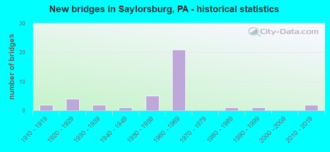
- New bridges - historical statistics
- 21910-1919
- 41920-1929
- 21930-1939
- 11940-1949
- 51950-1959
- 211960-1969
- 11980-1989
- 11990-1999
- 22010-2019

- Reconstructed bridges - Historical Statistics
- 31970-1979
- 01980-1989
- 01990-1999
- 42000-2009
- 22010-2019


- Bridge Condition - Deck
- 4.3%Excellent
- 21.7%Very good
- 17.4%Good
- 21.7%Satisfactory
- 13.0%Fair
- 21.7%Poor

- Bridge Condition - Superstructure
- 7.7%Very good
- 11.5%Good
- 38.5%Satisfactory
- 19.2%Fair
- 23.1%Poor

- Bridge Condition - Substructure
- 3.8%Very good
- 23.1%Good
- 26.9%Satisfactory
- 38.5%Fair
- 7.7%Poor

- Bridge Condition - Channel
- 5.0%Excellent
- 10.0%Good
- 10.0%Satisfactory
- 55.0%Fair
- 20.0%Poor
Find on map >> Show street view
Structure Number: 26668, Location: PA.33OVER CHERRYVALLEY RD (Lat: 40.884947, Lng: -75.308794), Route carried "on" structure: State highway 33, Year Built: 1958, Year Reconstructed: 1984, Status: Open, Structure Length: 1.16m (3.81ft), Average Daily Traffic: 37,369 (year 2021), Truck Traffic: 15%, Average Future Daily Traffic: 46,243 (year 2032), Design Load: HS 20, Features Intersected: SR 2002(LR 45007)
Minimum Vertical Clearance: 30+ m (98+ ft), Kilometerpoint: 3.594, Lanes on structure: 4, Lanes under structure: 2, Base Highway Network: Yes, Owner: State Highway Agency, Approaching Roadway Width: 14.6m (47.9ft), Skew: 23 degrees, Material/Design: Concrete, Design/Construction: Tee Beam, Number Of Spans In Main Unit: 1, Length of Maximum Span: 9.8m (32.2ft), Curb-To-Curb Width: 24.4m (80.1ft), Out-to-Out Width: 26.7m (87.6ft)
Condition: Deck: Satisfactory, Superstructure: Satisfactory, Substructure: Satisfactory, Operating Rating: 63.5 metric tons, Method Used To Determine Operating Rating: Load Factor (LF), Inventory Rating: 38.1 metric tons, Method Used To Determine Inventory Rating: Load Factor (LF), Structural Evaluation: Equal to present minimum criteria, Deck Geometry: Superior to present desirable criteria, Underclear: Meets minimum limits, Approach Roadway Alignment: Equal to present desirable criteria, Length Of Structure Improvement: 1.80m (5.91ft), Designated Inspection Frequency: Every 24 months, Inspection Date: August 2020, Bridge Improvement Cost: $11,000, Roadway Improvement Cost: $33,000, Total Project Cost: $151,000, Deck Structure Type: Concrete Cast-file-Place, Wearing Surface/Protective System: Wearing Surface: Latex Concrete
Find on map >> Show street view
Structure Number: 26671, Location: 0.1 MI.S.OF 209 INTER. (Lat: 40.923944, Lng: -75.299853), Route carried "on" structure: State highway 33, Year Built: 1963, Year Reconstructed: 1984, Status: Open, Structure Length: 1.19m (3.90ft), Average Daily Traffic: 37,369 (year 2021), Truck Traffic: 15%, Average Future Daily Traffic: 46,243 (year 2032), Design Load: HS 20, Features Intersected: SR 2008 (LR 949)
Minimum Vertical Clearance: 30+ m (98+ ft), Kilometerpoint: 8.470, Lanes on structure: 2, Lanes under structure: 2, Base Highway Network: Yes, Owner: State Highway Agency, Approaching Roadway Width: 25.6m (84.0ft), Skew: 20 degrees, Material/Design: Prestressed concrete, Design/Construction: Box Beam or Girders - Single/Spread, Number Of Spans In Main Unit: 1, Length of Maximum Span: 11.3m (37.1ft), Curb-To-Curb Width: 24.4m (80.1ft), Out-to-Out Width: 27.4m (89.9ft)
Condition: Deck: Satisfactory, Superstructure: Satisfactory, Substructure: Satisfactory, Operating Rating: 65.3 metric tons, Method Used To Determine Operating Rating: Load Factor (LF), Inventory Rating: 35.4 metric tons, Method Used To Determine Inventory Rating: Load Factor (LF), Structural Evaluation: Equal to present minimum criteria, Deck Geometry: Superior to present desirable criteria, Underclear: Meets minimum limits, Approach Roadway Alignment: Equal to present desirable criteria, Length Of Structure Improvement: 1.80m (5.91ft), Designated Inspection Frequency: Every 24 months, Inspection Date: November 2019, Bridge Improvement Cost: $12,000, Roadway Improvement Cost: $35,000, Total Project Cost: $160,000, Deck Structure Type: Concrete Cast-file-Place, Wearing Surface/Protective System: Wearing Surface: Latex Concrete
Find on map >> Show street view
Structure Number: 2679, Location: US209 & US209BUS.JCT. (Lat: 40.927833, Lng: -75.317108), Route carried "on" structure: Alternate US 209, Year Built: 1963, Status: Open, Structure Length: 1.86m (6.10ft), Average Daily Traffic: 12,368 (year 2022), Truck Traffic: 5%, Average Future Daily Traffic: 17,047 (year 2032), Design Load: HS 20, Features Intersected: US209 BUS.(SR 2012)
Minimum Vertical Clearance: 30+ m (98+ ft), Kilometerpoint: 18.672, Lanes on structure: 4, Lanes under structure: 2, Base Highway Network: Yes, Owner: State Highway Agency, Approaching Roadway Width: 25.6m (84.0ft), Skew: 24 degrees, Material/Design: Prestressed concrete, Design/Construction: Stringer/Multi-beam, Number Of Spans In Main Unit: 1, Length of Maximum Span: 18.0m (59.1ft), Curb-To-Curb Width: 24.4m (80.1ft), Out-to-Out Width: 27.3m (89.6ft)
Condition: Deck: Fair, Superstructure: Satisfactory, Substructure: Satisfactory, Operating Rating: 44.5 metric tons, Method Used To Determine Operating Rating: Load Factor (LF), Structural Evaluation: High priority of corrective action, Deck Geometry: Superior to present desirable criteria, Underclear: Somewhat better than minimum adequacy, Approach Roadway Alignment: Equal to present desirable criteria, Length Of Structure Improvement: 2.50m (8.20ft), Designated Inspection Frequency: Every 24 months, Inspection Date: November 2019, Bridge Improvement Cost: $60,000, Roadway Improvement Cost: $177,000, Total Project Cost: $810,000, Deck Structure Type: Concrete Cast-file-Place, Wearing Surface/Protective System: Wearing Surface: Monolithic Concrete
Find on map >> Show street view
Structure Number: 26791, Location: SCIOTA (Lat: 40.925453, Lng: -75.305119), Route carried "on" structure: Alternate US 209, Year Built: 1963, Status: Open, Structure Length: 1.68m (5.51ft), Average Daily Traffic: 12,368 (year 2022), Truck Traffic: 5%, Average Future Daily Traffic: 17,047 (year 2032), Design Load: HS 20, Features Intersected: LAKE CREEK
Minimum Vertical Clearance: 30+ m (98+ ft), Kilometerpoint: 19.500, Lanes on structure: 4, Base Highway Network: Yes, Owner: State Highway Agency, Approaching Roadway Width: 20.7m (67.9ft), Skew: 20 degrees, Material/Design: Prestressed concrete, Design/Construction: Stringer/Multi-beam, Number Of Spans In Main Unit: 1, Length of Maximum Span: 16.2m (53.1ft), Curb or Sidewalk Widths: Left: 0.5m (1.6ft), Right: 0.5m (1.6ft), Curb-To-Curb Width: 19.5m (64.0ft), Out-to-Out Width: 22.4m (73.5ft)
Condition: Deck: Poor, Superstructure: Good, Substructure: Fair, Channel: Fair, Operating Rating: 57.2 metric tons, Method Used To Determine Operating Rating: Load Factor (LF), Inventory Rating: 1.8 metric tons, Method Used To Determine Inventory Rating: Load Factor (LF), Structural Evaluation: High priority of corrective action, Deck Geometry: Better than present minimum criteria, Waterway Adequacy: Superior to present desirable criteria, Approach Roadway Alignment: Equal to present desirable criteria, Length Of Structure Improvement: 2.40m (7.87ft), Designated Inspection Frequency: Every 24 months, Inspection Date: November 2019, Bridge Improvement Cost: $47,000, Roadway Improvement Cost: $138,000, Total Project Cost: $635,000, Deck Structure Type: Closed Grating, Wearing Surface/Protective System: Wearing Surface: Bituminous
Find on map >> Show street view
Structure Number: 26792, Location: AT 209 INTERCHANGE (Lat: 40.925694, Lng: -75.300164), Route carried "on" structure: US 209, Year Built: 1963, Status: Open, Structure Length: 1.58m (5.18ft), Average Daily Traffic: 41,372 (year 2022), Truck Traffic: 11%, Average Future Daily Traffic: 56,548 (year 2032), Design Load: HS 20, Features Intersected: US209(LR164ALT)&RAMPSE&F, Facility Carried by Structure: PA 33 (LR 796)
Minimum Vertical Clearance: 30+ m (98+ ft), Kilometerpoint: 20.376, Lanes on structure: 4, Lanes under structure: 8, Base Highway Network: Yes, Owner: State Highway Agency, Approaching Roadway Width: 25.6m (84.0ft), Skew: 20 degrees, Material/Design: Prestressed concrete, Design/Construction: Box Beam or Girders - Single/Spread, Number Of Spans In Main Unit: 1, Length of Maximum Span: 15.2m (49.9ft), Curb-To-Curb Width: 25.6m (84.0ft), Out-to-Out Width: 27.3m (89.6ft)
Condition: Deck: Satisfactory, Superstructure: Satisfactory, Substructure: Satisfactory, Operating Rating: 40.8 metric tons, Method Used To Determine Operating Rating: Load Factor (LF), Inventory Rating: 24.5 metric tons, Method Used To Determine Inventory Rating: Load Factor (LF), Structural Evaluation: Equal to present minimum criteria, Deck Geometry: Superior to present desirable criteria, Underclear: Meets minimum limits, Approach Roadway Alignment: Equal to present desirable criteria, Length Of Structure Improvement: 2.30m (7.55ft), Designated Inspection Frequency: Every 24 months, Inspection Date: August 2021, Deck Structure Type: Concrete Cast-file-Place, Wearing Surface/Protective System: Wearing Surface: Latex Concrete
Find on map >> Show street view
Structure Number: 26793, Location: S.END OF SNYDERSVIL RAMPS (Lat: 40.945447, Lng: -75.292197), Route carried "on" structure: US 209, Year Built: 1963, Year Reconstructed: 2011, Status: Open, Structure Length: 2.29m (7.51ft), Average Daily Traffic: 41,372 (year 2022), Truck Traffic: 11%, Average Future Daily Traffic: 56,548 (year 2032), Design Load: HS 20, Features Intersected: MCMICHAEL CREEK
Minimum Vertical Clearance: 30+ m (98+ ft), Kilometerpoint: 22.661, Lanes on structure: 4, Base Highway Network: Yes, Owner: State Highway Agency, Approaching Roadway Width: 24.7m (81.0ft), Skew: 30 degrees, Material/Design: Prestressed concrete, Design/Construction: Stringer/Multi-beam, Number Of Spans In Main Unit: 1, Length of Maximum Span: 22.9m (75.1ft), Curb-To-Curb Width: 24.7m (81.0ft), Out-to-Out Width: 26.8m (87.9ft)
Condition: Deck: Good, Superstructure: Good, Substructure: Good, Channel: Fair, Operating Rating: 73.5 metric tons, Method Used To Determine Operating Rating: Load Factor (LF), Inventory Rating: 16.3 metric tons, Method Used To Determine Inventory Rating: Load Factor (LF), Structural Evaluation: Meets minimum limits, Deck Geometry: Superior to present desirable criteria, Waterway Adequacy: Equal to present desirable criteria, Approach Roadway Alignment: Equal to present desirable criteria, Length Of Structure Improvement: 3.00m (9.84ft), Designated Inspection Frequency: Every 24 months, Inspection Date: August 2021, Bridge Improvement Cost: $33,000, Roadway Improvement Cost: $97,000, Total Project Cost: $446,000, Deck Structure Type: Concrete Cast-file-Place, Wearing Surface/Protective System: Wearing Surface: Monolithic Concrete, Deck Protection: Epoxy Coated Reinforcing
Find on map >> Show street view
Structure Number: 26952, Location: PA33 INTERCHANGE (Lat: 40.894094, Lng: -75.312914), Route carried "on" structure: State highway , Year Built: 1963, Status: Open, Structure Length: 4.05m (13.29ft), Average Daily Traffic: 5,969 (year 2022), Truck Traffic: 4%, Average Future Daily Traffic: 8,622 (year 2032), Design Load: HS 20, Features Intersected: PA 33, Facility Carried by Structure: SR 2004(LR 165)
Minimum Vertical Clearance: 30+ m (98+ ft), Kilometerpoint: 0.000, Lanes on structure: 2, Lanes under structure: 8, Owner: State Highway Agency, Approaching Roadway Width: 9.8m (32.2ft), Skew: 4 degrees, Material/Design: Steel, Design/Construction: Stringer/Multi-beam, Number Of Spans In Main Unit: 1, Length of Maximum Span: 38.4m (126.0ft), Curb or Sidewalk Widths: Left: 0.5m (1.6ft), Right: 0.5m (1.6ft), Curb-To-Curb Width: 9.8m (32.2ft), Out-to-Out Width: 11.4m (37.4ft)
Condition: Deck: Fair, Superstructure: Fair, Substructure: Satisfactory, Operating Rating: 65.3 metric tons, Method Used To Determine Operating Rating: Load Factor (LF), Inventory Rating: 39.0 metric tons, Method Used To Determine Inventory Rating: Load Factor (LF), Structural Evaluation: Somewhat better than minimum adequacy, Deck Geometry: Meets minimum limits, Underclear: Meets minimum limits, Approach Roadway Alignment: Equal to present desirable criteria, Length Of Structure Improvement: 4.90m (16.08ft), Designated Inspection Frequency: Every 24 months, Inspection Date: August 2021, Bridge Improvement Cost: $23,000, Roadway Improvement Cost: $66,000, Total Project Cost: $305,000, Deck Structure Type: Concrete Cast-file-Place, Wearing Surface/Protective System: Wearing Surface: Latex Concrete
Find on map >> Show street view
Structure Number: 26959, Location: BOSSARDSVILLE RD. (Lat: 40.927342, Lng: -75.308542), Route carried "on" structure: State highway , Year Built: 1958, Status: Open, Structure Length: 1.58m (5.18ft), Average Daily Traffic: 994 (year 2020), Truck Traffic: 11%, Average Future Daily Traffic: 1,885 (year 2032), Design Load: HS 20, Features Intersected: LAKE CREEK, Facility Carried by Structure: SR 2008 (LR 45008)
Minimum Vertical Clearance: 30+ m (98+ ft), Kilometerpoint: 0.000, Lanes on structure: 2, Owner: State Highway Agency, Approaching Roadway Width: 7.3m (24.0ft), Skew: 3 degrees, Material/Design: Steel, Design/Construction: Stringer/Multi-beam, Number Of Spans In Main Unit: 1, Length of Maximum Span: 14.9m (48.9ft), Curb-To-Curb Width: 8.9m (29.2ft), Out-to-Out Width: 9.6m (31.5ft)
Condition: Deck: Satisfactory, Superstructure: Fair, Substructure: Fair, Channel: Fair, Operating Rating: 40.8 metric tons, Method Used To Determine Operating Rating: Load Factor (LF), Inventory Rating: 24.5 metric tons, Method Used To Determine Inventory Rating: Load Factor (LF), Structural Evaluation: Somewhat better than minimum adequacy, Deck Geometry: Somewhat better than minimum adequacy, Waterway Adequacy: Better than present minimum criteria, Approach Roadway Alignment: Better than present minimum criteria, Length Of Structure Improvement: 2.30m (7.55ft), Designated Inspection Frequency: Every 24 months, Underwater Inspection Frequency: Every 60 months, Inspection Date: March 2021, Underwater Inspection Date: September 2021, Bridge Improvement Cost: $4,000, Roadway Improvement Cost: $12,000, Total Project Cost: $55,000, Deck Structure Type: Corrugated Steel, Wearing Surface/Protective System: Wearing Surface: Bituminous
Find on map >> Show street view
Structure Number: 26963, Location: MANOR DRIVE OVER US 209 (Lat: 40.948058, Lng: -75.291394), Route carried "on" structure: State highway , Year Built: 1963, Year Reconstructed: 2012, Status: Open, Structure Length: 4.75m (15.58ft), Average Daily Traffic: 546 (year 2022), Truck Traffic: 7%, Average Future Daily Traffic: 3,146 (year 2032), Design Load: HS 20, Features Intersected: US 209/PA 33(LR 796), Facility Carried by Structure: SR 2010 (MANOR DR)
Minimum Vertical Clearance: 30+ m (98+ ft), Kilometerpoint: 0.000, Lanes on structure: 2, Lanes under structure: 4, Owner: State Highway Agency, Approaching Roadway Width: 13.1m (43.0ft), Skew: 2 degrees, Material/Design: Prestressed concrete, Design/Construction: Stringer/Multi-beam, Number Of Spans In Main Unit: 1, Number Of Approach Spans: 2, Length of Maximum Span: 28.0m (91.9ft), Curb or Sidewalk Widths: Left: 0.2m (0.7ft), Right: 0.2m (0.7ft), Curb-To-Curb Width: 12.8m (42.0ft), Out-to-Out Width: 13.9m (45.6ft)
Condition: Deck: Good, Superstructure: Satisfactory, Substructure: Good, Operating Rating: 67.1 metric tons, Method Used To Determine Operating Rating: Load Factor (LF), Inventory Rating: 22.7 metric tons, Method Used To Determine Inventory Rating: Load Factor (LF), Structural Evaluation: Equal to present minimum criteria, Deck Geometry: Superior to present desirable criteria, Underclear: High priority of corrective action, Approach Roadway Alignment: Equal to present desirable criteria, Length Of Structure Improvement: 4.80m (15.75ft), Designated Inspection Frequency: Every 24 months, Inspection Date: January 2021, Deck Structure Type: Concrete Cast-file-Place, Wearing Surface/Protective System: Wearing Surface: Latex Concrete
Find on map >> Show street view
Structure Number: 26965, Location: MANOR DRIVE (Lat: 40.950758, Lng: -75.286725), Route carried "on" structure: State highway , Year Built: 1960, Status: Open, Structure Length: 3.81m (12.50ft), Average Daily Traffic: 546 (year 2022), Truck Traffic: 7%, Average Future Daily Traffic: 3,146 (year 2032), Design Load: HS 20, Features Intersected: MCMICHAEL CREEK, Facility Carried by Structure: SR 2010(MANOR DR.)
Minimum Vertical Clearance: 30+ m (98+ ft), Kilometerpoint: 0.546, Lanes on structure: 2, Owner: State Highway Agency, Approaching Roadway Width: 6.7m (22.0ft), Material/Design: Steel, Design/Construction: Stringer/Multi-beam, Number Of Spans In Main Unit: 2, Length of Maximum Span: 18.6m (61.0ft), Curb or Sidewalk Widths: Left: 0.5m (1.6ft), Right: 0.5m (1.6ft), Curb-To-Curb Width: 8.5m (27.9ft), Out-to-Out Width: 10.2m (33.5ft)
Condition: Deck: Good, Superstructure: Fair, Substructure: Fair, Channel: Fair, Operating Rating: 80.7 metric tons, Method Used To Determine Operating Rating: Load Factor (LF), Inventory Rating: 48.1 metric tons, Method Used To Determine Inventory Rating: Load Factor (LF), Structural Evaluation: Somewhat better than minimum adequacy, Deck Geometry: Somewhat better than minimum adequacy, Waterway Adequacy: Equal to present desirable criteria, Approach Roadway Alignment: Equal to present desirable criteria, Length Of Structure Improvement: 4.80m (15.75ft), Designated Inspection Frequency: Every 24 months, Inspection Date: November 2020, Bridge Improvement Cost: $11,000, Roadway Improvement Cost: $34,000, Total Project Cost: $153,000, Deck Structure Type: Concrete Cast-file-Place, Wearing Surface/Protective System: Wearing Surface: Bituminous
Find on map >> Show street view
Structure Number: 26971, Location: 900 FT.N.OF US 209 (Lat: 40.930858, Lng: -75.317244), Route carried "on" structure: Business US 209B, Year Built: 1928, Year Reconstructed: 2012, Status: Open, Structure Length: 2.50m (8.20ft), Average Daily Traffic: 4,480 (year 2021), Truck Traffic: 4%, Average Future Daily Traffic: 4,058 (year 2032), Features Intersected: MCMICHAELS CREEK, Facility Carried by Structure: SR 2012(LR 164SP.)
Minimum Vertical Clearance: 30+ m (98+ ft), Kilometerpoint: 4.205, Lanes on structure: 2, Owner: State Highway Agency, Approaching Roadway Width: 8.5m (27.9ft), Material/Design: Masonry, Design/Construction: Arch - Deck, Number Of Spans In Main Unit: 3, Length of Maximum Span: 7.3m (24.0ft), Curb-To-Curb Width: 8.1m (26.6ft), Out-to-Out Width: 8.8m (28.9ft)
Condition: Deck: Very good, Superstructure: Good, Substructure: Good, Channel: Fair, Operating Rating: 79.8 metric tons, Method Used To Determine Operating Rating: Field evaluation and documented engineering judgment, Inventory Rating: 48.1 metric tons, Method Used To Determine Inventory Rating: Field evaluation and documented engineering judgment, Structural Evaluation: Better than present minimum criteria, Deck Geometry: High priority of corrective action, Waterway Adequacy: Equal to present minimum criteria, Approach Roadway Alignment: Better than present minimum criteria, Length Of Structure Improvement: 3.20m (10.50ft), Designated Inspection Frequency: Every 24 months, Inspection Date: March 2020, Bridge Improvement Cost: $77,000, Roadway Improvement Cost: $228,000, Total Project Cost: $1,044,000, Deck Structure Type: Concrete Cast-file-Place, Wearing Surface/Protective System: Wearing Surface: Bituminous, Membrane: Preformed Fabric, Deck Protection: Epoxy Coated Reinforcing
Find on map >> Show street view
Structure Number: 26972, Location: 1 MILE S OF SNYDERSVILLE (Lat: 40.947539, Lng: -75.304322), Route carried "on" structure: Business US 209B, Year Built: 1925, Year Reconstructed: 2011, Status: Open, Structure Length: 1.52m (4.99ft), Average Daily Traffic: 4,480 (year 2021), Truck Traffic: 4%, Average Future Daily Traffic: 4,058 (year 2032), Design Load: HS 20, Features Intersected: APPENZELL CREEK, Facility Carried by Structure: US 209 BUS.(LR164)
Minimum Vertical Clearance: 30+ m (98+ ft), Kilometerpoint: 6.246, Lanes on structure: 2, Owner: State Highway Agency, Approaching Roadway Width: 8.2m (26.9ft), Skew: 1 degrees, Material/Design: Concrete, Design/Construction: Arch - Deck, Number Of Spans In Main Unit: 1, Length of Maximum Span: 15.2m (49.9ft), Curb-To-Curb Width: 7.5m (24.6ft), Out-to-Out Width: 7.9m (25.9ft)
Condition: Deck: Very good, Superstructure: Satisfactory, Substructure: Fair, Channel: Fair, Inventory Rating: 99.8 metric tons, Method Used To Determine Inventory Rating: Load Factor (LF), Structural Evaluation: Somewhat better than minimum adequacy, Deck Geometry: High priority of replacement, Waterway Adequacy: Better than present minimum criteria, Approach Roadway Alignment: Equal to present desirable criteria, Length Of Structure Improvement: 2.20m (7.22ft), Designated Inspection Frequency: Every 24 months, Inspection Date: August 2021, Bridge Improvement Cost: $48,000, Roadway Improvement Cost: $141,000, Total Project Cost: $647,000, Deck Structure Type: Concrete Cast-file-Place, Wearing Surface/Protective System: Wearing Surface: Bituminous, Membrane: Preformed Fabric, Deck Protection: Epoxy Coated Reinforcing
Find on map >> Show street view
Structure Number: 26973, Location: SNYDERSVILLE (Lat: 40.958278, Lng: -75.292881), Route carried "on" structure: Business US 209B, Year Built: 1925, Status: Posted for load, Structure Length: 1.13m (3.71ft), Average Daily Traffic: 8,064 (year 2022), Truck Traffic: 4%, Average Future Daily Traffic: 9,670 (year 2032), Design Load: HS 20, Features Intersected: KETTLE CREEK, Facility Carried by Structure: US 209 BUS.(LR164)
Minimum Vertical Clearance: 30+ m (98+ ft), Kilometerpoint: 8.064, Lanes on structure: 2, Owner: State Highway Agency, Approaching Roadway Width: 8.5m (27.9ft), Skew: 4 degrees, Material/Design: Concrete, Design/Construction: Tee Beam, Number Of Spans In Main Unit: 1, Length of Maximum Span: 10.4m (34.1ft), Curb or Sidewalk Widths: Left: 0.6m (2.0ft), Right: 0.0m, Curb-To-Curb Width: 9.0m (29.5ft), Out-to-Out Width: 10.3m (33.8ft)
Condition: Deck: Poor, Superstructure: Poor, Substructure: Poor, Channel: Poor, Operating Rating: 29.0 metric tons, Method Used To Determine Operating Rating: Load Factor (LF), Inventory Rating: 17.2 metric tons, Method Used To Determine Inventory Rating: Load Factor (LF), Structural Evaluation: Meets minimum limits, Deck Geometry: High priority of replacement, Waterway Adequacy: Equal to present minimum criteria, Approach Roadway Alignment: Equal to present desirable criteria, Bridge Posting: Required (Relationship of Operating Rating to Maximum Legal Load: 30.0 - 39.9% below), Length Of Structure Improvement: 1.70m (5.58ft), Designated Inspection Frequency: Every 24 months, Other Special Inspection Frequency: Every 12 months, Inspection Date: Febuary 2020, Other Special Inspection Date: Febuary 2021, Bridge Improvement Cost: $49,000, Roadway Improvement Cost: $143,000, Total Project Cost: $656,000, Deck Structure Type: Concrete Cast-file-Place, Wearing Surface/Protective System: Wearing Surface: Bituminous
Find on map >> Show street view
Structure Number: 26998, Location: 2 MI.W.OF SR 3015 (Lat: 40.852664, Lng: -75.360661), Route carried "on" structure: State highway , Year Built: 1925, Status: Open, Structure Length: 0.73m (2.40ft), Average Daily Traffic: 309 (year 2020), Truck Traffic: 9%, Average Future Daily Traffic: 540 (year 2032), Features Intersected: AQUASHICOLA CREEK, Facility Carried by Structure: SR 3002(LR 45052)
Minimum Vertical Clearance: 30+ m (98+ ft), Kilometerpoint: 11.980, Lanes on structure: 2, Owner: State Highway Agency, Approaching Roadway Width: 4.9m (16.1ft), Skew: 3 degrees, Material/Design: Masonry, Design/Construction: Arch - Deck, Number Of Spans In Main Unit: 1, Length of Maximum Span: 7.3m (24.0ft), Curb-To-Curb Width: 5.5m (18.0ft), Out-to-Out Width: 6.6m (21.7ft)
Condition: Superstructure: Fair, Substructure: Fair, Channel: Fair, Operating Rating: 49.0 metric tons, Method Used To Determine Operating Rating: Field evaluation and documented engineering judgment, Inventory Rating: 32.7 metric tons, Method Used To Determine Inventory Rating: Field evaluation and documented engineering judgment, Structural Evaluation: Somewhat better than minimum adequacy, Deck Geometry: High priority of corrective action, Waterway Adequacy: Equal to present desirable criteria, Approach Roadway Alignment: Equal to present desirable criteria, Length Of Structure Improvement: 0.90m (2.95ft), Designated Inspection Frequency: Every 24 months, Inspection Date: March 2021, Bridge Improvement Cost: $27,000, Roadway Improvement Cost: $150,000, Total Project Cost: $360,000
Find on map >> Show street view
Structure Number: 27022, Location: ROLLING HILLS ROAD (Lat: 40.874275, Lng: -75.332142), Route carried "on" structure: State highway , Year Built: 1960, Year Reconstructed: 2018, Status: Open, Structure Length: 1.62m (5.31ft), Average Daily Traffic: 1,200 (year 2022), Truck Traffic: 5%, Average Future Daily Traffic: 1,896 (year 2032), Design Load: HS 20, Features Intersected: AQUASHICOLA CREEK, Facility Carried by Structure: SR 3015(LR 45006)
Minimum Vertical Clearance: 30+ m (98+ ft), Kilometerpoint: 0.885, Lanes on structure: 2, Owner: State Highway Agency, Approaching Roadway Width: 9.1m (29.9ft), Material/Design: Prestressed concrete, Design/Construction: Box Beam or Girders - Multiple, Number Of Spans In Main Unit: 1, Length of Maximum Span: 15.5m (50.9ft), Curb or Sidewalk Widths: Left: 0.5m (1.6ft), Right: 0.5m (1.6ft), Curb-To-Curb Width: 10.6m (34.8ft), Out-to-Out Width: 12.2m (40.0ft)
Condition: Deck: Very good, Superstructure: Satisfactory, Substructure: Satisfactory, Channel: Fair, Operating Rating: 90.7 metric tons, Method Used To Determine Operating Rating: Load Factor (LF), Inventory Rating: 39.0 metric tons, Method Used To Determine Inventory Rating: Load Factor (LF), Structural Evaluation: Equal to present minimum criteria, Deck Geometry: Equal to present minimum criteria, Waterway Adequacy: Equal to present desirable criteria, Approach Roadway Alignment: Equal to present desirable criteria, Length Of Structure Improvement: 2.30m (7.55ft), Designated Inspection Frequency: Every 24 months, Inspection Date: January 2021, Deck Structure Type: Concrete Cast-file-Place, Wearing Surface/Protective System: Wearing Surface: Monolithic Concrete, Deck Protection: Epoxy Coated Reinforcing
Find on map >> Show street view
Structure Number: 27027, Location: VILLAGE OF SAYLORSBURG (Lat: 40.894978, Lng: -75.321619), Route carried "on" structure: State highway , Year Built: 1938, Status: Open, Structure Length: 0.70m (2.30ft), Average Daily Traffic: 10,633 (year 2020), Truck Traffic: 4%, Average Future Daily Traffic: 17,763 (year 2032), Design Load: HS 20, Features Intersected: LAKE CREEK, Facility Carried by Structure: SR 3017(LR 930)
Minimum Vertical Clearance: 30+ m (98+ ft), Kilometerpoint: 4.749, Lanes on structure: 2, Owner: State Highway Agency, Approaching Roadway Width: 9.1m (29.9ft), Skew: 1 degrees, Material/Design: Concrete, Design/Construction: Tee Beam, Number Of Spans In Main Unit: 1, Length of Maximum Span: 6.4m (21.0ft), Curb-To-Curb Width: 13.1m (43.0ft), Out-to-Out Width: 14.0m (45.9ft)
Condition: Deck: Fair, Superstructure: Satisfactory, Substructure: Fair, Channel: Fair, Operating Rating: 42.6 metric tons, Method Used To Determine Operating Rating: Load Factor (LF), Inventory Rating: 25.4 metric tons, Method Used To Determine Inventory Rating: Load Factor (LF), Structural Evaluation: Somewhat better than minimum adequacy, Deck Geometry: Somewhat better than minimum adequacy, Waterway Adequacy: Equal to present desirable criteria, Approach Roadway Alignment: Equal to present desirable criteria, Length Of Structure Improvement: 1.30m (4.27ft), Designated Inspection Frequency: Every 24 months, Inspection Date: November 2019, Bridge Improvement Cost: $16,000, Roadway Improvement Cost: $48,000, Total Project Cost: $219,000, Deck Structure Type: Concrete Cast-file-Place, Wearing Surface/Protective System: Wearing Surface: Bituminous
Find on map >> Show street view
Structure Number: 27034, Location: PENSYL CK. RD.@ SMILEY LA (Lat: 40.950814, Lng: -75.331033), Route carried "on" structure: State highway , Year Built: 1956, Year Reconstructed: 2018, Status: Open, Structure Length: 1.92m (6.30ft), Average Daily Traffic: 1,116 (year 2022), Truck Traffic: 2%, Average Future Daily Traffic: 1,634 (year 2032), Design Load: HS 20, Features Intersected: APPENZELL CREEK, Facility Carried by Structure: SR 3020(LR 45073)
Minimum Vertical Clearance: 30+ m (98+ ft), Kilometerpoint: 0.000, Lanes on structure: 2, Owner: State Highway Agency, Approaching Roadway Width: 7.0m (23.0ft), Skew: 3 degrees, Material/Design: Prestressed concrete, Design/Construction: Box Beam or Girders - Multiple, Number Of Spans In Main Unit: 1, Length of Maximum Span: 18.3m (60.0ft), Curb-To-Curb Width: 8.6m (28.2ft), Out-to-Out Width: 9.5m (31.2ft)
Condition: Deck: Very good, Superstructure: Satisfactory, Substructure: Good, Channel: Satisfactory, Operating Rating: 42.6 metric tons, Method Used To Determine Operating Rating: Load Factor (LF), Inventory Rating: 1.8 metric tons, Method Used To Determine Inventory Rating: Load Factor (LF), Structural Evaluation: High priority of corrective action, Deck Geometry: Somewhat better than minimum adequacy, Waterway Adequacy: Equal to present minimum criteria, Approach Roadway Alignment: Equal to present desirable criteria, Length Of Structure Improvement: 2.60m (8.53ft), Designated Inspection Frequency: Every 24 months, Inspection Date: June 2020, Bridge Improvement Cost: $6,000, Roadway Improvement Cost: $17,000, Total Project Cost: $79,000, Deck Structure Type: Concrete Cast-file-Place, Wearing Surface/Protective System: Wearing Surface: Monolithic Concrete, Deck Protection: Epoxy Coated Reinforcing
Find on map >> Show street view
Structure Number: 27035, Location: NEOLA ROAD (Lat: 40.953033, Lng: -75.333492), Route carried "on" structure: State highway , Year Built: 1941, Year Reconstructed: 1982, Status: Open, Structure Length: 1.19m (3.90ft), Average Daily Traffic: 1,453 (year 2020), Truck Traffic: 3%, Average Future Daily Traffic: 2,681 (year 2032), Design Load: HS 20, Features Intersected: APPENZELL CREEK, Facility Carried by Structure: SR 3021(LR 45021)
Minimum Vertical Clearance: 30+ m (98+ ft), Kilometerpoint: 2.361, Lanes on structure: 2, Owner: State Highway Agency, Approaching Roadway Width: 6.1m (20.0ft), Skew: 3 degrees, Material/Design: Steel, Design/Construction: Stringer/Multi-beam, Number Of Spans In Main Unit: 1, Length of Maximum Span: 11.3m (37.1ft), Curb-To-Curb Width: 7.3m (24.0ft), Out-to-Out Width: 8.4m (27.6ft)
Condition: Deck: Good, Superstructure: Fair, Substructure: Satisfactory, Channel: Fair, Operating Rating: 50.8 metric tons, Method Used To Determine Operating Rating: Load Factor (LF), Inventory Rating: 29.9 metric tons, Method Used To Determine Inventory Rating: Load Factor (LF), Structural Evaluation: Somewhat better than minimum adequacy, Deck Geometry: Meets minimum limits, Waterway Adequacy: Equal to present desirable criteria, Approach Roadway Alignment: Better than present minimum criteria, Length Of Structure Improvement: 1.80m (5.91ft), Designated Inspection Frequency: Every 24 months, Inspection Date: November 2020, Bridge Improvement Cost: $4,000, Roadway Improvement Cost: $11,000, Total Project Cost: $51,000, Deck Structure Type: Concrete Cast-file-Place, Wearing Surface/Protective System: Wearing Surface: Monolithic Concrete, Deck Protection: Epoxy Coated Reinforcing
Find on map >> Show street view
Structure Number: 2704, Location: MIDDLE EASTON BELMONT PK (Lat: 40.943858, Lng: -75.295228), Route carried "on" structure: State highway , Year Built: 1910, Status: Posted for load, Structure Length: 1.58m (5.18ft), Average Daily Traffic: 1,400 (year 2022), Truck Traffic: 10%, Average Future Daily Traffic: 2,133 (year 2032), Design Load: HS 20, Features Intersected: MCMICHAEL CREEK, Facility Carried by Structure: SR 3023 (LR 949)
Minimum Vertical Clearance: 30+ m (98+ ft), Kilometerpoint: 1.308, Lanes on structure: 2, Owner: State Highway Agency, Approaching Roadway Width: 6.7m (22.0ft), Material/Design: Masonry, Design/Construction: Arch - Deck, Number Of Spans In Main Unit: 2, Length of Maximum Span: 7.3m (24.0ft), Curb-To-Curb Width: 5.8m (19.0ft), Out-to-Out Width: 6.7m (22.0ft)
Condition: Superstructure: Poor, Substructure: Poor, Channel: Poor, Operating Rating: 32.7 metric tons, Method Used To Determine Operating Rating: Field evaluation and documented engineering judgment, Inventory Rating: 21.8 metric tons, Method Used To Determine Inventory Rating: Field evaluation and documented engineering judgment, Structural Evaluation: Meets minimum limits, Deck Geometry: High priority of replacement, Waterway Adequacy: Better than present minimum criteria, Approach Roadway Alignment: Equal to present desirable criteria, Length Of Structure Improvement: 2.30m (7.55ft), Designated Inspection Frequency: Every 24 months, Other Special Inspection Frequency: Every 12 months, Inspection Date: March 2020, Other Special Inspection Date: March 2021, Bridge Improvement Cost: $7,000, Roadway Improvement Cost: $21,000, Total Project Cost: $95,000
Find on map >> Show street view
Structure Number: 27041, Location: M. EASTON-BELMONT PIKE (Lat: 40.949075, Lng: -75.296003), Route carried "on" structure: Spur State highway , Year Built: 1954, Status: Open, Structure Length: 2.35m (7.71ft), Average Daily Traffic: 2,119 (year 2021), Truck Traffic: 5%, Average Future Daily Traffic: 3,803 (year 2032), Design Load: HS 20, Features Intersected: APPENZELL CREEK, Facility Carried by Structure: SR 3023 (LR 949)
Minimum Vertical Clearance: 30+ m (98+ ft), Kilometerpoint: 2.441, Lanes on structure: 2, Owner: State Highway Agency, Approaching Roadway Width: 7.3m (24.0ft), Skew: 4 degrees, Material/Design: Steel, Design/Construction: Stringer/Multi-beam, Number Of Spans In Main Unit: 1, Length of Maximum Span: 21.3m (69.9ft), Curb-To-Curb Width: 7.3m (24.0ft), Out-to-Out Width: 7.9m (25.9ft)
Condition: Deck: Poor, Superstructure: Poor, Substructure: Fair, Channel: Poor, Operating Rating: 59.0 metric tons, Method Used To Determine Operating Rating: Load Factor (LF), Inventory Rating: 35.4 metric tons, Method Used To Determine Inventory Rating: Load Factor (LF), Structural Evaluation: Meets minimum limits, Deck Geometry: High priority of replacement, Waterway Adequacy: Equal to present desirable criteria, Approach Roadway Alignment: Better than present minimum criteria, Length Of Structure Improvement: 3.00m (9.84ft), Designated Inspection Frequency: Every 24 months, Other Special Inspection Frequency: Every 12 months, Inspection Date: August 2021, Other Special Inspection Date: August 2021, Bridge Improvement Cost: $6,000, Roadway Improvement Cost: $17,000, Total Project Cost: $78,000, Deck Structure Type: Open Grating
Find on map >> Show street view
Structure Number: 27084, Location: SAYLORSBURG (Lat: 40.904956, Lng: -75.302153), Route carried "on" structure: City street , Year Built: 1930, Status: Open, Structure Length: 0.82m (2.69ft), Average Daily Traffic: 50 (year 2005), Average Future Daily Traffic: 50 (year 2035), Features Intersected: LAKE CREEK, Facility Carried by Structure: GOLF COURSE RD
Minimum Vertical Clearance: 30+ m (98+ ft), Kilometerpoint: 0.000, Lanes on structure: 2, Owner: Town or Township Highway Agency, Approaching Roadway Width: 4.6m (15.1ft), Skew: 3 degrees, Material/Design: Concrete, Design/Construction: Tee Beam, Number Of Spans In Main Unit: 1, Length of Maximum Span: 7.9m (25.9ft), Curb or Sidewalk Widths: Left: 0.2m (0.7ft), Right: 0.2m (0.7ft), Curb-To-Curb Width: 4.8m (15.7ft), Out-to-Out Width: 5.5m (18.0ft)
Condition: Deck: Satisfactory, Superstructure: Satisfactory, Substructure: Fair, Channel: Fair, Operating Rating: 76.2 metric tons, Method Used To Determine Operating Rating: Field evaluation and documented engineering judgment, Inventory Rating: 45.4 metric tons, Method Used To Determine Inventory Rating: Field evaluation and documented engineering judgment, Structural Evaluation: Somewhat better than minimum adequacy, Deck Geometry: High priority of replacement, Waterway Adequacy: Better than present minimum criteria, Approach Roadway Alignment: Better than present minimum criteria, Length Of Structure Improvement: 1.50m (4.92ft), Designated Inspection Frequency: Every 24 months, Inspection Date: September 2020, Bridge Improvement Cost: $3,000, Roadway Improvement Cost: $9,000, Total Project Cost: $41,000, Deck Structure Type: Concrete Cast-file-Place, Wearing Surface/Protective System: Wearing Surface: Bituminous
Find on map >> Show street view
Structure Number: 27086, Location: 0.7 MI. W OF SCIOTA (Lat: 40.932064, Lng: -75.332575), Route carried "on" structure: City street , Year Built: 1986, Status: Open, Structure Length: 1.92m (6.30ft), Average Daily Traffic: 427 (year 2001), Average Future Daily Traffic: 125 (year 2025), Design Load: HS 20, Features Intersected: MCMICHAEL CREEK, Facility Carried by Structure: T-221
Minimum Vertical Clearance: 30+ m (98+ ft), Kilometerpoint: 0.000, Lanes on structure: 2, Owner: County Highway Agency, Approaching Roadway Width: 8.5m (27.9ft), Skew: 2 degrees, Material/Design: Prestressed concrete, Design/Construction: Box Beam or Girders - Multiple, Number Of Spans In Main Unit: 1, Length of Maximum Span: 18.3m (60.0ft), Curb-To-Curb Width: 8.8m (28.9ft), Out-to-Out Width: 9.8m (32.2ft)
Condition: Deck: Poor, Superstructure: Poor, Substructure: Good, Channel: Satisfactory, Operating Rating: 46.3 metric tons, Method Used To Determine Operating Rating: Load Factor (LF), Inventory Rating: 21.8 metric tons, Method Used To Determine Inventory Rating: Load Factor (LF), Structural Evaluation: Meets minimum limits, Deck Geometry: Somewhat better than minimum adequacy, Waterway Adequacy: Better than present minimum criteria, Approach Roadway Alignment: Equal to present desirable criteria, Length Of Structure Improvement: 1.90m (6.23ft), Designated Inspection Frequency: Every 24 months, Inspection Date: August 2020, Deck Structure Type: Other, Wearing Surface/Protective System: Wearing Surface: Bituminous, Membrane: Preformed Fabric
Find on map >> Show street view
Structure Number: 27087, Location: SANDHILL (Lat: 40.947114, Lng: -75.308631), Route carried "on" structure: City street , Year Built: 1915, Status: Posted for load, Structure Length: 1.07m (3.51ft), Average Daily Traffic: 187 (year 2005), Truck Traffic: 1%, Average Future Daily Traffic: 500 (year 2030), Features Intersected: APPENZELL CREEK, Facility Carried by Structure: FOUNDRY RD T-231
Minimum Vertical Clearance: 30+ m (98+ ft), Kilometerpoint: 0.000, Lanes on structure: 2, Owner: County Highway Agency, Approaching Roadway Width: 4.9m (16.1ft), Material/Design: Masonry, Design/Construction: Arch - Deck, Number Of Spans In Main Unit: 1, Length of Maximum Span: 10.7m (35.1ft), Curb-To-Curb Width: 5.3m (17.4ft), Out-to-Out Width: 5.3m (17.4ft)
Condition: Superstructure: Poor, Substructure: Fair, Channel: Good, Operating Rating: 32.7 metric tons, Method Used To Determine Operating Rating: Field evaluation and documented engineering judgment, Inventory Rating: 21.8 metric tons, Method Used To Determine Inventory Rating: Field evaluation and documented engineering judgment, Structural Evaluation: Meets minimum limits, Deck Geometry: High priority of replacement, Waterway Adequacy: Better than present minimum criteria, Approach Roadway Alignment: Equal to present desirable criteria, Length Of Structure Improvement: 1.10m (3.61ft), Designated Inspection Frequency: Every 24 months, Other Special Inspection Frequency: Every 12 months, Inspection Date: April 2020, Other Special Inspection Date: April 2021, Bridge Improvement Cost: $2,000, Roadway Improvement Cost: $5,000, Total Project Cost: $23,000, Deck Structure Type: Other
Find on map >> Show street view
Structure Number: 39926, Location: SAYLORSBURG (Lat: 40.897947, Lng: -75.312353), Route carried "on" structure: City street , Year Built: 1997, Status: Open, Structure Length: 0.98m (3.22ft), Average Daily Traffic: 387 (year 2005), Truck Traffic: 1%, Average Future Daily Traffic: 635 (year 2030), Design Load: HS 25 or greater, Features Intersected: LAKE CREEK, Facility Carried by Structure: EAST TERRACE DRIVE
Minimum Vertical Clearance: 30+ m (98+ ft), Kilometerpoint: 0.000, Lanes on structure: 2, Owner: Town or Township Highway Agency, Approaching Roadway Width: 6.7m (22.0ft), Skew: 1 degrees, Material/Design: Prestressed concrete, Design/Construction: Box Beam or Girders - Multiple, Number Of Spans In Main Unit: 1, Length of Maximum Span: 9.4m (30.8ft), Curb or Sidewalk Widths: Left: 0.2m (0.7ft), Right: 0.2m (0.7ft), Curb-To-Curb Width: 8.8m (28.9ft), Out-to-Out Width: 9.8m (32.2ft)
Condition: Deck: Poor, Superstructure: Poor, Substructure: Fair, Channel: Poor, Operating Rating: 51.7 metric tons, Method Used To Determine Operating Rating: Load Factor (LF), Inventory Rating: 28.1 metric tons, Method Used To Determine Inventory Rating: Load Factor (LF), Structural Evaluation: Meets minimum limits, Deck Geometry: Equal to present minimum criteria, Waterway Adequacy: Somewhat better than minimum adequacy, Approach Roadway Alignment: Equal to present desirable criteria, Designated Inspection Frequency: Every 24 months, Underwater Inspection Frequency: Every 24 months, Inspection Date: September 2020, Underwater Inspection Date: September 2020, Deck Structure Type: Other, Wearing Surface/Protective System: Wearing Surface: Bituminous
Find on map >> Show street view
Structure Number: 47974, Location: SCIOTA (Lat: 40.932000, Lng: -75.319556), Route carried "on" structure: Other road , Year Built: 2013, Status: Open, Structure Length: 2.01m (6.59ft), Average Daily Traffic: 100 (year 2018), Average Future Daily Traffic: 122 (year 2038), Design Load: HL 93, Features Intersected: MCMICHAEL CREEK, Facility Carried by Structure: T-221
Minimum Vertical Clearance: 30+ m (98+ ft), Kilometerpoint: 0.000, Lanes on structure: 2, Toll: Toll bridge, Owner: Town or Township Highway Agency, Approaching Roadway Width: 6.1m (20.0ft), Skew: 3 degrees, Material/Design: Prestressed concrete, Design/Construction: Box Beam or Girders - Single/Spread, Number Of Spans In Main Unit: 1, Length of Maximum Span: 16.2m (53.1ft), Curb-To-Curb Width: 7.5m (24.6ft), Out-to-Out Width: 8.4m (27.6ft)
Condition: Deck: Very good, Superstructure: Very good, Substructure: Good, Channel: Good, Operating Rating: 61.6 metric tons, Method Used To Determine Operating Rating: Assigned ratings based on Load and Resistance Factor Design (LRFD) reported by rating factor (RF) using HL93 loadings, Inventory Rating: 36.9 metric tons, Method Used To Determine Inventory Rating: Assigned ratings based on Load and Resistance Factor Design (LRFD) reported by rating factor (RF) using HL93 loadings, Structural Evaluation: Better than present minimum criteria, Deck Geometry: Equal to present minimum criteria, Waterway Adequacy: Superior to present desirable criteria, Approach Roadway Alignment: Equal to present desirable criteria, Designated Inspection Frequency: Every 24 months, Inspection Date: August 2021, Deck Structure Type: Concrete Cast-file-Place, Wearing Surface/Protective System: Wearing Surface: Monolithic Concrete, Deck Protection: Epoxy Coated Reinforcing
Find on map >> Show street view
Structure Number: 53386, Location: AT JUNCT. WITH PA33 SB (Lat: 40.955858, Lng: -75.287297), Route carried "on" structure: US 209, Year Built: 2017, Status: Open, Structure Length: 4.11m (13.48ft), Average Daily Traffic: 15,034 (year 2020), Truck Traffic: 17%, Average Future Daily Traffic: 25,833 (year 2032), Design Load: HL 93, Features Intersected: Appenzell Creek
Minimum Vertical Clearance: 30+ m (98+ ft), Kilometerpoint: 23.889, Lanes on structure: 2, Base Highway Network: Yes, Owner: State Highway Agency, Maintenance Responsibility: Private, Approaching Roadway Width: 12.5m (41.0ft), Skew: 4 degrees, Material/Design: Prestressed concrete, Design/Construction: Stringer/Multi-beam, Number Of Spans In Main Unit: 1, Length of Maximum Span: 39.3m (128.9ft), Curb-To-Curb Width: 17.2m (56.4ft), Out-to-Out Width: 17.8m (58.4ft)
Condition: Deck: Excellent, Superstructure: Very good, Substructure: Very good, Channel: Excellent, Operating Rating: 50.5 metric tons, Method Used To Determine Operating Rating: Assigned ratings based on Load and Resistance Factor Design (LRFD) reported by rating factor (RF) using HL93 loadings, Inventory Rating: 37.9 metric tons, Method Used To Determine Inventory Rating: Assigned ratings based on Load and Resistance Factor Design (LRFD) reported by rating factor (RF) using HL93 loadings, Structural Evaluation: Equal to present desirable criteria, Deck Geometry: Superior to present desirable criteria, Waterway Adequacy: Superior to present desirable criteria, Approach Roadway Alignment: Equal to present desirable criteria, Designated Inspection Frequency: Every 24 months, Inspection Date: July 2020, Deck Structure Type: Concrete Cast-file-Place, Wearing Surface/Protective System: Wearing Surface: Integral Concrete, Deck Protection: Epoxy Coated Reinforcing
Find on map >> Show street view
Structure Number: 26668, Location: PA.33OVER CHERRYVALLEY RD (Lat: 40.884947, Lng: -75.308794), Route carried "under" structure: State highway , Year Built: 1958, Structure Length: 0. m, Average Daily Traffic: 260 (year 2022), Truck Traffic: 10%, Features Intersected: SR 2002(LR 45007), Facility Carried by Structure: PA 33 (LR 796)
Minimum Vertical Clearance: 4.63m (15.19ft), Kilometerpoint: 0.000, Lanes on structure: 4, Lanes under structure: 2, Material/Design: Concrete, Design/Construction: Tee Beam, Length of Maximum Span: 9.8m (32.2ft)
Find on map >> Show street view
Structure Number: 26671, Location: 0.1 MI.S.OF 209 INTER. (Lat: 40.923944, Lng: -75.299853), Route carried "under" structure: State highway , Year Built: 1963, Structure Length: 0. m, Average Daily Traffic: 1,559 (year 2022), Truck Traffic: 30%, Features Intersected: SR 2008 (LR 949), Facility Carried by Structure: PA 33 (LR 796)
Minimum Vertical Clearance: 4.30m (14.11ft), Kilometerpoint: 1.276, Lanes on structure: 2, Lanes under structure: 2, Material/Design: Prestressed concrete, Design/Construction: Box Beam or Girders - Single/Spread, Length of Maximum Span: 11.3m (37.1ft)
Find on map >> Show street view
Structure Number: 2679, Location: US209 & US209BUS.JCT. (Lat: 40.927833, Lng: -75.317108), Route carried "under" structure: Business State highway , Year Built: 1963, Structure Length: 0. m, Average Daily Traffic: 4,480 (year 2021), Truck Traffic: 4%, Features Intersected: US209 BUS.(SR 2012), Facility Carried by Structure: US 209(LR 164 ALT)
Minimum Vertical Clearance: 4.45m (14.60ft), Kilometerpoint: 3.322, Lanes on structure: 4, Lanes under structure: 2, Material/Design: Prestressed concrete, Design/Construction: Stringer/Multi-beam, Length of Maximum Span: 18.0m (59.1ft)
Find on map >> Show street view
Structure Number: 26792, Location: AT 209 INTERCHANGE (Lat: 40.925694, Lng: -75.300164), Route carried "under" structure: Alternate State highway , Year Built: 1963, Structure Length: 0. m, Average Daily Traffic: 4,675 (year 2022), Truck Traffic: 7%, Features Intersected: US209(LR164ALT)&RAMPSE&F, Facility Carried by Structure: PA 33 (LR 796)
Minimum Vertical Clearance: 4.39m (14.40ft), Kilometerpoint: 0.000, Lanes on structure: 4, Lanes under structure: 2, Material/Design: Prestressed concrete, Design/Construction: Box Beam or Girders - Single/Spread, Length of Maximum Span: 15.2m (49.9ft)
Find on map >> Show street view
Structure Number: 26792, Location: AT 209 INTERCHANGE (Lat: 40.925694, Lng: -75.300164), Route carried "under" structure: Ramp US 209, Year Built: 1963, Structure Length: 0. m, Average Daily Traffic: 6,347 (year 2022), Truck Traffic: 5%, Features Intersected: US209(LR164ALT)&RAMPSE&F, Facility Carried by Structure: PA 33 (LR 796)
Minimum Vertical Clearance: 4.39m (14.40ft), Kilometerpoint: 19.500, Lanes on structure: 4, Lanes under structure: 2, Material/Design: Prestressed concrete, Design/Construction: Box Beam or Girders - Single/Spread, Length of Maximum Span: 15.2m (49.9ft)
Find on map >> Show street view
Structure Number: 26792, Location: AT 209 INTERCHANGE (Lat: 40.925694, Lng: -75.300164), Route carried "under" structure: Ramp US 209, Year Built: 1963, Structure Length: 0. m, Average Daily Traffic: 6,021 (year 2022), Truck Traffic: 4%, Features Intersected: US209(LR164ALT)&RAMPSE&F, Facility Carried by Structure: PA 33 (LR 796)
Minimum Vertical Clearance: 4.54m (14.90ft), Kilometerpoint: 19.446, Lanes on structure: 4, Lanes under structure: 2, Material/Design: Prestressed concrete, Design/Construction: Box Beam or Girders - Single/Spread, Length of Maximum Span: 15.2m (49.9ft)
Find on map >> Show street view
Structure Number: 26792, Location: AT 209 INTERCHANGE (Lat: 40.925694, Lng: -75.300164), Route carried "under" structure: Alternate State highway , Year Built: 1963, Structure Length: 0. m, Average Daily Traffic: 964 (year 2022), Truck Traffic: 7%, Features Intersected: US209(LR164ALT)&RAMPSE&F, Facility Carried by Structure: PA 33 (LR 796)
Minimum Vertical Clearance: 4.55m (14.93ft), Kilometerpoint: 0.000, Lanes on structure: 4, Lanes under structure: 2, Material/Design: Prestressed concrete, Design/Construction: Box Beam or Girders - Single/Spread, Length of Maximum Span: 15.2m (49.9ft)
Find on map >> Show street view
Structure Number: 26952, Location: PA33 INTERCHANGE (Lat: 40.894094, Lng: -75.312914), Route carried "under" structure: State highway 33, Year Built: 1963, Structure Length: 0. m, Average Daily Traffic: 19,459 (year 2021), Truck Traffic: 15%, Features Intersected: PA 33, Facility Carried by Structure: SR 2004(LR 165)
Minimum Vertical Clearance: 4.54m (14.90ft), Kilometerpoint: 4.300, Lanes on structure: 2, Lanes under structure: 4, Material/Design: Steel, Design/Construction: Stringer/Multi-beam, Length of Maximum Span: 38.4m (126.0ft)
Find on map >> Show street view
Structure Number: 26952, Location: PA33 INTERCHANGE (Lat: 40.894094, Lng: -75.312914), Route carried "under" structure: State highway 33, Year Built: 1963, Structure Length: 0. m, Average Daily Traffic: 17,910 (year 2021), Truck Traffic: 15%, Features Intersected: PA 33, Facility Carried by Structure: SR 2004(LR 165)
Minimum Vertical Clearance: 4.39m (14.40ft), Kilometerpoint: 4.287, Lanes on structure: 2, Lanes under structure: 4, Material/Design: Steel, Design/Construction: Stringer/Multi-beam, Length of Maximum Span: 38.4m (126.0ft)
Find on map >> Show street view
Structure Number: 2696, Location: Bossardsville Road (Lat: 40.925661, Lng: -75.302481), Route carried "under" structure: US 209, Year Built: 1963, Structure Length: 0. m, Average Daily Traffic: 6,021 (year 2022), Truck Traffic: 4%, Features Intersected: US 209, Facility Carried by Structure: SR 2008 (LR 949)
Minimum Vertical Clearance: 4.88m (16.01ft), Kilometerpoint: 19.446, Lanes on structure: 2, Lanes under structure: 4, Material/Design: Prestressed concrete, Design/Construction: Stringer/Multi-beam, Length of Maximum Span: 21.3m (69.9ft)
Find on map >> Show street view
Structure Number: 2696, Location: Bossardsville Road (Lat: 40.925661, Lng: -75.302481), Route carried "under" structure: US 209, Year Built: 1963, Structure Length: 0. m, Average Daily Traffic: 6,347 (year 2022), Truck Traffic: 5%, Features Intersected: US 209, Facility Carried by Structure: SR 2008 (LR 949)
Minimum Vertical Clearance: 4.51m (14.80ft), Kilometerpoint: 19.500, Lanes on structure: 2, Lanes under structure: 4, Material/Design: Prestressed concrete, Design/Construction: Stringer/Multi-beam, Length of Maximum Span: 21.3m (69.9ft)
Find on map >> Show street view
Structure Number: 26963, Location: MANOR DRIVE OVER US 209 (Lat: 40.948058, Lng: -75.291394), Route carried "under" structure: US 209, Year Built: 1963, Structure Length: 0. m, Average Daily Traffic: 15,034 (year 2020), Truck Traffic: 17%, Features Intersected: US 209/PA 33(LR 796), Facility Carried by Structure: SR 2010 (MANOR DR)
Minimum Vertical Clearance: 4.45m (14.60ft), Kilometerpoint: 22.656, Lanes on structure: 2, Lanes under structure: 2, Material/Design: Prestressed concrete, Design/Construction: Stringer/Multi-beam, Length of Maximum Span: 28.0m (91.9ft)
Find on map >> Show street view
Structure Number: 26963, Location: MANOR DRIVE OVER US 209 (Lat: 40.948058, Lng: -75.291394), Route carried "under" structure: US 209, Year Built: 1963, Structure Length: 0. m, Average Daily Traffic: 16,335 (year 2020), Truck Traffic: 15%, Features Intersected: US 209/PA 33(LR 796), Facility Carried by Structure: SR 2010 (MANOR DR)
Minimum Vertical Clearance: 4.48m (14.70ft), Kilometerpoint: 22.661, Lanes on structure: 2, Lanes under structure: 2, Material/Design: Prestressed concrete, Design/Construction: Stringer/Multi-beam, Length of Maximum Span: 28.0m (91.9ft)