Bridge Statistics for Savanna, Illinois (IL)
Condition, Traffic, Stress, Structural Evaluation, Project Costs
- National Bridge Inventory (NBI) Statistics
- 22Number of bridges
- 466ft / 142mTotal length
- 28,710Total average daily traffic
- 3,841Total average daily truck traffic
- National Bridge Inventory (NBI) Registered Bridges for Savanna
- No street view available for this location
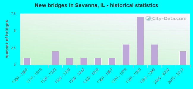
- New bridges - historical statistics
- 11900-1909
- 21920-1929
- 11930-1939
- 11940-1949
- 11950-1959
- 11960-1969
- 31970-1979
- 71980-1989
- 31990-1999
- 22010-2019

- Reconstructed bridges - Historical Statistics
- 11980-1989
- 01990-1999
- 12000-2009


- Bridge Condition - Deck
- 6.3%Very good
- 18.8%Good
- 56.3%Satisfactory
- 6.3%Fair
- 6.3%Poor
- 6.3%Serious

- Bridge Condition - Superstructure
- 12.5%Very good
- 18.8%Good
- 50.0%Satisfactory
- 6.3%Fair
- 6.3%Poor
- 6.3%Serious

- Bridge Condition - Substructure
- 12.5%Very good
- 50.0%Good
- 18.8%Satisfactory
- 12.5%Fair
- 6.3%Poor

- Bridge Condition - Channel
- 37.5%Very good
- 56.3%Good
- 6.3%Satisfactory

- Bridge Condition - Culverts
- 66.7%Very good
- 33.3%Satisfactory
Find on map >> Show street view
Structure Number: 80015, Location: 3.1 MI S JO DAV CO (Lat: 42.160469, Lng: -90.185864), Route carried "on" structure: State highway 84, Year Built: 1927, Year Reconstructed: 1991, Status: Open, Structure Length: 8.82m (28.94ft), Average Daily Traffic: 1,750 (year 2021), Truck Traffic: 15%, Average Future Daily Traffic: 1,900 (year 2040), Design Load: HS 20, Features Intersected: RUSH CREEK
Minimum Vertical Clearance: 30+ m (98+ ft), Kilometerpoint: 97.314, Lanes on structure: 2, Base Highway Network: Yes, Owner: State Highway Agency, Approaching Roadway Width: 9.8m (32.2ft), Material/Design: Steel continuous, Design/Construction: Stringer/Multi-beam, Number Of Spans In Main Unit: 5, Length of Maximum Span: 17.6m (57.7ft), Curb-To-Curb Width: 9.8m (32.2ft), Out-to-Out Width: 10.7m (35.1ft)
Condition: Deck: Satisfactory, Superstructure: Fair, Substructure: Good, Channel: Good, Operating Rating: 64.2 metric tons, Method Used To Determine Operating Rating: Load Factor (LF) rating reported by rating factor (RF) method using MS18 loading, Inventory Rating: 34.3 metric tons, Method Used To Determine Inventory Rating: Load Factor (LF) rating reported by rating factor (RF) method using MS18 loading, Structural Evaluation: Somewhat better than minimum adequacy, Deck Geometry: Somewhat better than minimum adequacy, Waterway Adequacy: Equal to present desirable criteria, Approach Roadway Alignment: Equal to present desirable criteria, Designated Inspection Frequency: Every 24 months, Inspection Date: October 2021, Deck Structure Type: Concrete Cast-file-Place, Wearing Surface/Protective System: Deck Protection: Epoxy Coated Reinforcing
Find on map >> Show street view
Structure Number: 80016, Location: 2 MI N SAVANNA (Lat: 42.139656, Lng: -90.165753), Route carried "on" structure: State highway 84, Year Built: 1929, Year Reconstructed: 2008, Status: Open, Structure Length: 1.44m (4.72ft), Average Daily Traffic: 1,950 (year 2021), Truck Traffic: 14%, Average Future Daily Traffic: 1,900 (year 2040), Design Load: HS 20+Mod, Features Intersected: DRAINAGE DITCH
Minimum Vertical Clearance: 30+ m (98+ ft), Kilometerpoint: 94.369, Lanes on structure: 2, Base Highway Network: Yes, Owner: State Highway Agency, Approaching Roadway Width: 7.3m (24.0ft), Skew: 4 degrees, Material/Design: Prestressed concrete, Design/Construction: Box Beam or Girders - Multiple, Number Of Spans In Main Unit: 1, Length of Maximum Span: 13.1m (43.0ft), Curb-To-Curb Width: 10.1m (33.1ft), Out-to-Out Width: 10.1m (33.1ft)
Condition: Deck: Satisfactory, Superstructure: Satisfactory, Substructure: Satisfactory, Channel: Good, Operating Rating: 63.2 metric tons, Method Used To Determine Operating Rating: Load Factor (LF) rating reported by rating factor (RF) method using MS18 loading, Inventory Rating: 37.9 metric tons, Method Used To Determine Inventory Rating: Load Factor (LF) rating reported by rating factor (RF) method using MS18 loading, Structural Evaluation: Equal to present minimum criteria, Deck Geometry: Somewhat better than minimum adequacy, Waterway Adequacy: Equal to present desirable criteria, Approach Roadway Alignment: Equal to present desirable criteria, Designated Inspection Frequency: Every 24 months, Inspection Date: May 2021, Deck Structure Type: Concrete Precast Panels, Wearing Surface/Protective System: Wearing Surface: Integral Concrete
Find on map >> Show street view
Structure Number: 80028, Location: 1.0 MI S JCT ILL 64 (Lat: 42.075281, Lng: -90.125225), Route carried "on" structure: State highway 84, Year Built: 1978, Status: Open, Structure Length: 10.84m (35.56ft), Average Daily Traffic: 4,500 (year 2021), Truck Traffic: 12%, Average Future Daily Traffic: 5,200 (year 2040), Design Load: HS 20+Mod, Features Intersected: PLUM RIVER
Minimum Vertical Clearance: 30+ m (98+ ft), Kilometerpoint: 85.212, Lanes on structure: 2, Base Highway Network: Yes, Owner: State Highway Agency, Approaching Roadway Width: 13.4m (44.0ft), Material/Design: Steel continuous, Design/Construction: Stringer/Multi-beam, Number Of Spans In Main Unit: 7, Length of Maximum Span: 21.3m (69.9ft), Curb-To-Curb Width: 13.1m (43.0ft), Out-to-Out Width: 14.0m (45.9ft)
Condition: Deck: Fair, Superstructure: Satisfactory, Substructure: Satisfactory, Channel: Good, Operating Rating: 58.0 metric tons, Method Used To Determine Operating Rating: Load Factor (LF) rating reported by rating factor (RF) method using MS18 loading, Inventory Rating: 34.7 metric tons, Method Used To Determine Inventory Rating: Load Factor (LF) rating reported by rating factor (RF) method using MS18 loading, Structural Evaluation: Equal to present minimum criteria, Deck Geometry: Equal to present minimum criteria, Waterway Adequacy: Equal to present desirable criteria, Approach Roadway Alignment: Equal to present desirable criteria, Designated Inspection Frequency: Every 24 months, Other Special Inspection Frequency: Every 24 months, Inspection Date: October 2021, Other Special Inspection Date: October 2021, Deck Structure Type: Concrete Cast-file-Place, Wearing Surface/Protective System: Deck Protection: Epoxy Coated Reinforcing
Find on map >> Show street view
Structure Number: 8004, Location: .3 MI S IL64 SAVANNA (Lat: 42.084883, Lng: -90.131303), Route carried "on" structure: State highway 84, Year Built: 1988, Status: Open, Structure Length: 7.95m (26.08ft), Average Daily Traffic: 5,950 (year 2021), Truck Traffic: 9%, Average Future Daily Traffic: 7,800 (year 2040), Design Load: HS 20, Features Intersected: DM&E RR
Minimum Vertical Clearance: 30+ m (98+ ft), Kilometerpoint: 86.419, Lanes on structure: 2, Base Highway Network: Yes, Owner: State Highway Agency, Approaching Roadway Width: 9.1m (29.9ft), Skew: 2 degrees, Material/Design: Prestressed concrete continuous, Design/Construction: Stringer/Multi-beam, Number Of Spans In Main Unit: 4, Length of Maximum Span: 22.1m (72.5ft), Curb-To-Curb Width: 9.1m (29.9ft), Out-to-Out Width: 11.5m (37.7ft)
Condition: Deck: Satisfactory, Superstructure: Good, Substructure: Good, Operating Rating: 72.3 metric tons, Method Used To Determine Operating Rating: Load Factor (LF) rating reported by rating factor (RF) method using MS18 loading, Inventory Rating: 43.1 metric tons, Method Used To Determine Inventory Rating: Load Factor (LF) rating reported by rating factor (RF) method using MS18 loading, Structural Evaluation: Better than present minimum criteria, Deck Geometry: Meets minimum limits, Underclear: Superior to present desirable criteria, Approach Roadway Alignment: Equal to present desirable criteria, Designated Inspection Frequency: Every 48 months, Inspection Date: January 2020, Deck Structure Type: Concrete Cast-file-Place, Wearing Surface/Protective System: Deck Protection: Epoxy Coated Reinforcing
Find on map >> Show street view
Structure Number: 80041, Location: .1 MI S IL64 SAVANNA (Lat: 42.088508, Lng: -90.133308), Route carried "on" structure: State highway 84, Year Built: 1988, Status: Open, Structure Length: 8.06m (26.44ft), Average Daily Traffic: 5,950 (year 2021), Truck Traffic: 9%, Average Future Daily Traffic: 10,200 (year 2040), Design Load: HS 20+Mod, Features Intersected: SOO LINE RR/CITY ST
Minimum Vertical Clearance: 30+ m (98+ ft), Kilometerpoint: 86.854, Lanes on structure: 2, Lanes under structure: 2, Base Highway Network: Yes, Owner: State Highway Agency, Approaching Roadway Width: 9.1m (29.9ft), Skew: 2 degrees, Material/Design: Prestressed concrete continuous, Design/Construction: Stringer/Multi-beam, Number Of Spans In Main Unit: 4, Length of Maximum Span: 23.5m (77.1ft), Curb or Sidewalk Widths: Left: 0.0m, Right: 1.5m (4.9ft), Curb-To-Curb Width: 9.1m (29.9ft), Out-to-Out Width: 11.5m (37.7ft)
Condition: Deck: Satisfactory, Superstructure: Satisfactory, Substructure: Satisfactory, Operating Rating: 75.2 metric tons, Method Used To Determine Operating Rating: Load Factor (LF) rating reported by rating factor (RF) method using MS18 loading, Inventory Rating: 44.4 metric tons, Method Used To Determine Inventory Rating: Load Factor (LF) rating reported by rating factor (RF) method using MS18 loading, Structural Evaluation: Equal to present minimum criteria, Deck Geometry: Meets minimum limits, Underclear: Meets minimum limits, Approach Roadway Alignment: Equal to present desirable criteria, Designated Inspection Frequency: Every 24 months, Inspection Date: November 2021, Deck Structure Type: Concrete Cast-file-Place, Wearing Surface/Protective System: Deck Protection: Epoxy Coated Reinforcing
Find on map >> Show street view
Structure Number: 80045, Location: 0.6MI. E. OF IL 84 (Lat: 42.098119, Lng: -90.127036), Route carried "on" structure: US 52, Year Built: 1999, Status: Open, Structure Length: 7.20m (23.62ft), Average Daily Traffic: 3,350 (year 2021), Truck Traffic: 15%, Average Future Daily Traffic: 3,900 (year 2040), Design Load: HS 20+Mod, Features Intersected: PLUM RIVER
Minimum Vertical Clearance: 30+ m (98+ ft), Kilometerpoint: 4.747, Lanes on structure: 2, Base Highway Network: Yes, Owner: State Highway Agency, Approaching Roadway Width: 12.2m (40.0ft), Material/Design: Prestressed concrete continuous, Design/Construction: Stringer/Multi-beam, Number Of Spans In Main Unit: 2, Length of Maximum Span: 35.3m (115.8ft), Curb or Sidewalk Widths: Left: 1.8m (5.9ft), Right: 0.0m, Curb-To-Curb Width: 12.0m (39.4ft), Out-to-Out Width: 14.8m (48.6ft)
Condition: Deck: Satisfactory, Superstructure: Good, Substructure: Good, Channel: Good, Operating Rating: 64.5 metric tons, Method Used To Determine Operating Rating: Load Factor (LF) rating reported by rating factor (RF) method using MS18 loading, Inventory Rating: 39.9 metric tons, Method Used To Determine Inventory Rating: Load Factor (LF) rating reported by rating factor (RF) method using MS18 loading, Structural Evaluation: Better than present minimum criteria, Deck Geometry: Somewhat better than minimum adequacy, Waterway Adequacy: Equal to present desirable criteria, Approach Roadway Alignment: Equal to present desirable criteria, Designated Inspection Frequency: Every 24 months, Inspection Date: October 2021, Deck Structure Type: Concrete Cast-file-Place, Wearing Surface/Protective System: Deck Protection: Epoxy Coated Reinforcing
Find on map >> Show street view
Structure Number: 80052, Location: NW EDGE OF SAVANNA (Lat: 42.104072, Lng: -90.160914), Route carried "on" structure: US 52, Year Built: 2018, Status: Open, Structure Length: 74.80m (245.41ft), Average Daily Traffic: 2,300 (year 2021), Truck Traffic: 17%, Average Future Daily Traffic: 2,100 (year 2040), Design Load: HS 25 or greater, Features Intersected: MISS RIV & BNRR
Minimum Vertical Clearance: 5.18m (16.99ft), Kilometerpoint: 0.016, Lanes on structure: 2, Base Highway Network: Yes, Owner: State Highway Agency, Approaching Roadway Width: 12.2m (40.0ft), Navigation Control: Yes ( Vertical Clearance: 24.7m (81.0ft), Horizontal Clearance: 154.8m (507.9ft)), Material/Design: Steel, Design/Construction: Arch - Thru, Number Of Spans In Main Unit: 1, Number Of Approach Spans: 11, Length of Maximum Span: 166.4m (545.9ft), Curb-To-Curb Width: 12.2m (40.0ft), Out-to-Out Width: 13.2m (43.3ft)
Condition: Deck: Good, Superstructure: Very good, Substructure: Good, Channel: Very good, Operating Rating: 46.0 metric tons, Method Used To Determine Operating Rating: Load and Resistance Factor Rating (LRFR) rating reported by rating factor(RF) method using HL-93 loadings, Inventory Rating: 35.6 metric tons, Method Used To Determine Inventory Rating: Load and Resistance Factor Rating (LRFR) rating reported by rating factor(RF) method using HL-93 loadings, Structural Evaluation: Better than present minimum criteria, Deck Geometry: Equal to present minimum criteria, Waterway Adequacy: Equal to present desirable criteria, Approach Roadway Alignment: Somewhat better than minimum adequacy, Designated Inspection Frequency: Every 24 months, Critical Feature Inspection Frequency: Every 24 months, Underwater Inspection Frequency: Every 60 months, Inspection Date: September 2021, Critical Feature Inspection Date: September 2021, Underwater Inspection Date: September 2021, Deck Structure Type: Concrete Cast-file-Place, Wearing Surface/Protective System: Deck Protection: Epoxy Coated Reinforcing
Find on map >> Show street view
Structure Number: 83007, Location: 1 MI NE SAVANA (Lat: 42.112711, Lng: -90.117903), Route carried "on" structure: County highway , Year Built: 1966, Status: Open, Structure Length: 0.79m (2.59ft), Average Daily Traffic: 200 (year 2021), Truck Traffic: 10%, Average Future Daily Traffic: 500 (year 2040), Design Load: HS 15, Features Intersected: TRIBUTARY OF PLUM R, Facility Carried by Structure: NORTH OAKTON ROAD
Minimum Vertical Clearance: 30+ m (98+ ft), Kilometerpoint: 0.161, Lanes on structure: 2, Owner: Town or Township Highway Agency, Approaching Roadway Width: 6.4m (21.0ft), Material/Design: Concrete, Design/Construction: Culvert, Number Of Spans In Main Unit: 2, Length of Maximum Span: 3.9m (12.8ft)
Condition: Channel: Good, Culverts: Very good, Operating Rating: 40.8 metric tons, Method Used To Determine Operating Rating: Load Factor (LF) rating reported by rating factor (RF) method using MS18 loading, Inventory Rating: 24.6 metric tons, Method Used To Determine Inventory Rating: Load Factor (LF) rating reported by rating factor (RF) method using MS18 loading, Structural Evaluation: Equal to present minimum criteria, Waterway Adequacy: Equal to present desirable criteria, Approach Roadway Alignment: Equal to present desirable criteria, Designated Inspection Frequency: Every 24 months, Inspection Date: May 2020
Find on map >> Show street view
Structure Number: 83008, Location: 3 MI NNE SAVANNA (Lat: 42.134436, Lng: -90.097689), Route carried "on" structure: County highway , Year Built: 1977, Status: Open, Structure Length: 1.65m (5.41ft), Average Daily Traffic: 25 (year 2021), Average Future Daily Traffic: 25 (year 2040), Design Load: HS 20, Features Intersected: CAMP CREEK, Facility Carried by Structure: W MESSMER ROAD
Minimum Vertical Clearance: 30+ m (98+ ft), Kilometerpoint: 3.830, Lanes on structure: 2, Owner: Town or Township Highway Agency, Approaching Roadway Width: 5.5m (18.0ft), Skew: 2 degrees, Material/Design: Prestressed concrete, Design/Construction: Box Beam or Girders - Multiple, Number Of Spans In Main Unit: 1, Length of Maximum Span: 15.4m (50.5ft), Curb-To-Curb Width: 7.3m (24.0ft), Out-to-Out Width: 7.3m (24.0ft)
Condition: Deck: Satisfactory, Superstructure: Satisfactory, Substructure: Good, Channel: Good, Operating Rating: 44.4 metric tons, Method Used To Determine Operating Rating: Assigned rating based on Load Factor Design (LFD) reported by rating factor (RF) using MS18 loading, Inventory Rating: 32.4 metric tons, Method Used To Determine Inventory Rating: Assigned rating based on Load Factor Design (LFD) reported by rating factor (RF) using MS18 loading, Structural Evaluation: Equal to present minimum criteria, Deck Geometry: Equal to present minimum criteria, Waterway Adequacy: Equal to present desirable criteria, Approach Roadway Alignment: Equal to present desirable criteria, Designated Inspection Frequency: Every 24 months, Inspection Date: May 2020, Deck Structure Type: Concrete Precast Panels, Wearing Surface/Protective System: Wearing Surface: Gravel
Find on map >> Show street view
Structure Number: 8301, Location: 1.5MI E MISS PALISAD (Lat: 42.145233, Lng: -90.123003), Route carried "on" structure: County highway , Year Built: 1994, Status: Open, Structure Length: 3.54m (11.61ft), Average Daily Traffic: 150 (year 2021), Truck Traffic: 15%, Average Future Daily Traffic: 200 (year 2040), Design Load: HS 20, Features Intersected: CAMP CREEK, Facility Carried by Structure: ZION RD - CH 16
Minimum Vertical Clearance: 30+ m (98+ ft), Kilometerpoint: 5.504, Lanes on structure: 2, Owner: County Highway Agency, Approaching Roadway Width: 7.3m (24.0ft), Skew: 2 degrees, Material/Design: Concrete, Design/Construction: Channel Beam, Number Of Spans In Main Unit: 3, Length of Maximum Span: 11.6m (38.1ft), Curb-To-Curb Width: 9.1m (29.9ft), Out-to-Out Width: 9.1m (29.9ft)
Condition: Deck: Very good, Superstructure: Satisfactory, Substructure: Good, Channel: Good, Operating Rating: 44.1 metric tons, Method Used To Determine Operating Rating: Assigned rating based on Load Factor Design (LFD) reported by rating factor (RF) using MS18 loading, Inventory Rating: 32.4 metric tons, Method Used To Determine Inventory Rating: Assigned rating based on Load Factor Design (LFD) reported by rating factor (RF) using MS18 loading, Structural Evaluation: Equal to present minimum criteria, Deck Geometry: Equal to present minimum criteria, Waterway Adequacy: Equal to present desirable criteria, Approach Roadway Alignment: Better than present minimum criteria, Designated Inspection Frequency: Every 24 months, Inspection Date: May 2020, Deck Structure Type: Concrete Precast Panels, Wearing Surface/Protective System: Wearing Surface: Gravel
Find on map >> Show street view
Structure Number: 83117, Location: 3 MI NE SAVANNA (Lat: 42.133094, Lng: -90.091461), Route carried "on" structure: County highway , Year Built: 1986, Status: Open, Structure Length: 1.41m (4.63ft), Average Daily Traffic: 50 (year 2021), Truck Traffic: 8%, Average Future Daily Traffic: 200 (year 2040), Design Load: HS 20, Features Intersected: CAMP CR, Facility Carried by Structure: N OAKTON RD
Minimum Vertical Clearance: 30+ m (98+ ft), Kilometerpoint: 6.131, Lanes on structure: 2, Owner: Town or Township Highway Agency, Approaching Roadway Width: 5.5m (18.0ft), Material/Design: Prestressed concrete, Design/Construction: Box Beam or Girders - Multiple, Number Of Spans In Main Unit: 1, Length of Maximum Span: 13.4m (44.0ft), Curb-To-Curb Width: 7.3m (24.0ft), Out-to-Out Width: 7.3m (24.0ft)
Condition: Deck: Good, Superstructure: Good, Substructure: Very good, Channel: Very good, Operating Rating: 44.4 metric tons, Method Used To Determine Operating Rating: Assigned rating based on Load Factor Design (LFD) reported by rating factor (RF) using MS18 loading, Inventory Rating: 32.4 metric tons, Method Used To Determine Inventory Rating: Assigned rating based on Load Factor Design (LFD) reported by rating factor (RF) using MS18 loading, Structural Evaluation: Better than present minimum criteria, Deck Geometry: Equal to present minimum criteria, Waterway Adequacy: Equal to present minimum criteria, Approach Roadway Alignment: Equal to present desirable criteria, Designated Inspection Frequency: Every 48 months, Inspection Date: May 2020, Deck Structure Type: Concrete Precast Panels
Find on map >> Show street view
Structure Number: 83503, Location: .25 MI E SAVANNA (Lat: 42.080767, Lng: -90.106517), Route carried "on" structure: County highway , Year Built: 1977, Status: Open, Structure Length: 3.79m (12.43ft), Average Daily Traffic: 775 (year 2021), Truck Traffic: 37%, Average Future Daily Traffic: 1,500 (year 2040), Design Load: HS 20, Features Intersected: PLUM RIVER, Facility Carried by Structure: TR-38 (W Wacker Rd
Minimum Vertical Clearance: 30+ m (98+ ft), Kilometerpoint: 0.595, Lanes on structure: 2, Owner: Town or Township Highway Agency, Approaching Roadway Width: 6.7m (22.0ft), Skew: 1 degrees, Material/Design: Prestressed concrete, Design/Construction: Box Beam or Girders - Multiple, Number Of Spans In Main Unit: 3, Length of Maximum Span: 12.1m (39.7ft), Curb-To-Curb Width: 7.3m (24.0ft), Out-to-Out Width: 7.9m (25.9ft)
Condition: Deck: Satisfactory, Superstructure: Satisfactory, Substructure: Fair, Channel: Satisfactory, Operating Rating: 53.8 metric tons, Method Used To Determine Operating Rating: Load Factor (LF) rating reported by rating factor (RF) method using MS18 loading, Inventory Rating: 32.1 metric tons, Method Used To Determine Inventory Rating: Load Factor (LF) rating reported by rating factor (RF) method using MS18 loading, Structural Evaluation: Somewhat better than minimum adequacy, Deck Geometry: Meets minimum limits, Waterway Adequacy: Better than present minimum criteria, Approach Roadway Alignment: Equal to present minimum criteria, Designated Inspection Frequency: Every 24 months, Inspection Date: June 2020, Deck Structure Type: Concrete Precast Panels, Wearing Surface/Protective System: Wearing Surface: Gravel
Find on map >> Show street view
Structure Number: 83504, Location: 1 MI SO OF SAVANNA (Lat: 42.069714, Lng: -90.110097), Route carried "on" structure: County highway , Year Built: 1984, Status: Open, Structure Length: 3.81m (12.50ft), Average Daily Traffic: 150 (year 2021), Truck Traffic: 9%, Average Future Daily Traffic: 25 (year 2040), Design Load: HS 20, Features Intersected: DRAINAGE DITCH, Facility Carried by Structure: WEST DOTY ROAD
Minimum Vertical Clearance: 30+ m (98+ ft), Kilometerpoint: 1.287, Lanes on structure: 2, Owner: Town or Township Highway Agency, Approaching Roadway Width: 6.1m (20.0ft), Skew: 3 degrees, Material/Design: Prestressed concrete, Design/Construction: Box Beam or Girders - Multiple, Number Of Spans In Main Unit: 3, Length of Maximum Span: 12.6m (41.3ft), Curb-To-Curb Width: 7.3m (24.0ft), Out-to-Out Width: 7.3m (24.0ft)
Condition: Deck: Poor, Superstructure: Poor, Substructure: Poor, Channel: Very good, Operating Rating: 37.9 metric tons, Method Used To Determine Operating Rating: Load Factor (LF) rating reported by rating factor (RF) method using MS18 loading, Inventory Rating: 18.1 metric tons, Method Used To Determine Inventory Rating: Load Factor (LF) rating reported by rating factor (RF) method using MS18 loading, Structural Evaluation: Meets minimum limits, Deck Geometry: Somewhat better than minimum adequacy, Waterway Adequacy: Equal to present desirable criteria, Approach Roadway Alignment: Equal to present desirable criteria, Designated Inspection Frequency: Every 24 months, Inspection Date: June 2020, Deck Structure Type: Concrete Precast Panels, Wearing Surface/Protective System: Wearing Surface: Gravel
Find on map >> Show street view
Structure Number: 83505, Location: SE EDGE OF SAVANNA (Lat: 42.080656, Lng: -90.113347), Route carried "on" structure: County highway , Year Built: 1996, Status: Open, Structure Length: 1.77m (5.81ft), Average Daily Traffic: 775 (year 2021), Truck Traffic: 37%, Average Future Daily Traffic: 1,250 (year 2040), Design Load: HS 20, Features Intersected: BNSF RR, Facility Carried by Structure: WACKER RD
Minimum Vertical Clearance: 30+ m (98+ ft), Kilometerpoint: 0.016, Lanes on structure: 2, Owner: Town or Township Highway Agency, Approaching Roadway Width: 7.0m (23.0ft), Skew: 3 degrees, Material/Design: Steel, Design/Construction: Stringer/Multi-beam, Number Of Spans In Main Unit: 1, Length of Maximum Span: 16.2m (53.1ft), Curb-To-Curb Width: 9.1m (29.9ft), Out-to-Out Width: 10.0m (32.8ft)
Condition: Deck: Satisfactory, Superstructure: Very good, Substructure: Very good, Operating Rating: 53.8 metric tons, Method Used To Determine Operating Rating: Load Factor (LF) rating reported by rating factor (RF) method using MS18 loading, Inventory Rating: 32.4 metric tons, Method Used To Determine Inventory Rating: Load Factor (LF) rating reported by rating factor (RF) method using MS18 loading, Structural Evaluation: Equal to present desirable criteria, Deck Geometry: Equal to present minimum criteria, Underclear: Equal to present desirable criteria, Approach Roadway Alignment: Equal to present minimum criteria, Designated Inspection Frequency: Every 48 months, Inspection Date: May 2020, Deck Structure Type: Concrete Cast-file-Place, Wearing Surface/Protective System: Deck Protection: Internally Sealed
Find on map >> Show street view
Structure Number: 8361, Location: 2 MILES S SAVANNA (Lat: 42.048533, Lng: -90.090106), Route carried "on" structure: County highway , Year Built: 1955, Status: Open, Structure Length: 1.52m (4.99ft), Average Daily Traffic: 400 (year 2021), Truck Traffic: 18%, Average Future Daily Traffic: 400 (year 2040), Design Load: H 15, Features Intersected: DRAINAGE DITCH, Facility Carried by Structure: W AIRPORT ROAD
Minimum Vertical Clearance: 30+ m (98+ ft), Kilometerpoint: 2.156, Lanes on structure: 2, Owner: Town or Township Highway Agency, Approaching Roadway Width: 5.8m (19.0ft), Material/Design: Steel, Design/Construction: Stringer/Multi-beam, Number Of Spans In Main Unit: 1, Length of Maximum Span: 15.0m (49.2ft), Curb-To-Curb Width: 7.3m (24.0ft), Out-to-Out Width: 7.7m (25.3ft)
Condition: Deck: Good, Superstructure: Satisfactory, Substructure: Good, Channel: Very good, Operating Rating: 36.3 metric tons, Method Used To Determine Operating Rating: Load Factor (LF) rating reported by rating factor (RF) method using MS18 loading, Inventory Rating: 21.7 metric tons, Method Used To Determine Inventory Rating: Load Factor (LF) rating reported by rating factor (RF) method using MS18 loading, Structural Evaluation: Equal to present minimum criteria, Deck Geometry: Somewhat better than minimum adequacy, Waterway Adequacy: Equal to present desirable criteria, Approach Roadway Alignment: Better than present minimum criteria, Designated Inspection Frequency: Every 24 months, Inspection Date: May 2020, Deck Structure Type: Concrete Cast-file-Place
Find on map >> Show street view
Structure Number: 83617, Location: 2 M SE OF SAVANNA (Lat: 42.050694, Lng: -90.082069), Route carried "on" structure: County highway , Year Built: 1982, Status: Open, Structure Length: 1.65m (5.41ft), Average Daily Traffic: 50 (year 2021), Truck Traffic: 40%, Average Future Daily Traffic: 150 (year 2040), Design Load: HS 20, Features Intersected: DEER CREEK, Facility Carried by Structure: SCENIC BLUFF ROAD
Minimum Vertical Clearance: 30+ m (98+ ft), Kilometerpoint: 3.203, Lanes on structure: 2, Owner: Town or Township Highway Agency, Approaching Roadway Width: 5.2m (17.1ft), Material/Design: Prestressed concrete, Design/Construction: Box Beam or Girders - Multiple, Number Of Spans In Main Unit: 1, Length of Maximum Span: 15.5m (50.9ft), Curb-To-Curb Width: 7.3m (24.0ft), Out-to-Out Width: 7.4m (24.3ft)
Condition: Deck: Serious, Superstructure: Serious, Substructure: Fair, Channel: Good, Operating Rating: 46.0 metric tons, Method Used To Determine Operating Rating: Load Factor (LF) rating reported by rating factor (RF) method using MS18 loading, Inventory Rating: 27.5 metric tons, Method Used To Determine Inventory Rating: Load Factor (LF) rating reported by rating factor (RF) method using MS18 loading, Structural Evaluation: High priority of corrective action, Deck Geometry: Equal to present minimum criteria, Waterway Adequacy: Better than present minimum criteria, Approach Roadway Alignment: Equal to present desirable criteria, Designated Inspection Frequency: Every 24 months, Other Special Inspection Frequency: Every 12 months, Inspection Date: May 2020, Other Special Inspection Date: November 2021, Deck Structure Type: Concrete Precast Panels, Wearing Surface/Protective System: Wearing Surface: Bituminous
Find on map >> Show street view
Structure Number: 83618, Location: 3 MI SE SAVANNA (Lat: 42.054519, Lng: -90.065625), Route carried "on" structure: County highway , Year Built: 1984, Status: Open, Structure Length: 1.94m (6.36ft), Average Daily Traffic: 25 (year 2021), Average Future Daily Traffic: 25 (year 2040), Design Load: HS 20, Features Intersected: BR OF PLUM RIVER, Facility Carried by Structure: HICKORY GROVE ROAD
Minimum Vertical Clearance: 30+ m (98+ ft), Kilometerpoint: 1.223, Lanes on structure: 2, Owner: Town or Township Highway Agency, Approaching Roadway Width: 4.9m (16.1ft), Material/Design: Prestressed concrete, Design/Construction: Box Beam or Girders - Multiple, Number Of Spans In Main Unit: 1, Length of Maximum Span: 18.6m (61.0ft), Curb-To-Curb Width: 7.3m (24.0ft), Out-to-Out Width: 7.3m (24.0ft)
Condition: Deck: Satisfactory, Superstructure: Satisfactory, Substructure: Good, Channel: Very good, Operating Rating: 44.4 metric tons, Method Used To Determine Operating Rating: Assigned rating based on Load Factor Design (LFD) reported by rating factor (RF) using MS18 loading, Inventory Rating: 32.4 metric tons, Method Used To Determine Inventory Rating: Assigned rating based on Load Factor Design (LFD) reported by rating factor (RF) using MS18 loading, Structural Evaluation: Equal to present minimum criteria, Deck Geometry: Equal to present minimum criteria, Waterway Adequacy: Equal to present desirable criteria, Approach Roadway Alignment: Better than present minimum criteria, Designated Inspection Frequency: Every 24 months, Inspection Date: May 2020, Deck Structure Type: Concrete Precast Panels
Find on map >> Show street view
Structure Number: 83634, Location: SW CORN SEC29 (Lat: 42.037178, Lng: -90.073094), Route carried "on" structure: County highway , Year Built: 1945, Status: Open, Structure Length: 0.70m (2.30ft), Average Daily Traffic: 75 (year 2021), Average Future Daily Traffic: 75 (year 2032), Features Intersected: NO NAME CRK, Facility Carried by Structure: SCENIC BLUFF RD
Minimum Vertical Clearance: 30+ m (98+ ft), Kilometerpoint: 1.271, Lanes on structure: 2, Owner: Town or Township Highway Agency, Approaching Roadway Width: 5.8m (19.0ft), Material/Design: Steel, Design/Construction: Culvert, Number Of Spans In Main Unit: 3, Length of Maximum Span: 1.8m (5.9ft)
Condition: Channel: Good, Culverts: Satisfactory, Operating Rating: 45.0 metric tons, Method Used To Determine Operating Rating: Load Factor (LF) rating reported by rating factor (RF) method using MS18 loading, Inventory Rating: 26.9 metric tons, Method Used To Determine Inventory Rating: Load Factor (LF) rating reported by rating factor (RF) method using MS18 loading, Structural Evaluation: Equal to present minimum criteria, Waterway Adequacy: Equal to present minimum criteria, Approach Roadway Alignment: Better than present minimum criteria, Designated Inspection Frequency: Every 24 months, Inspection Date: May 2020
Find on map >> Show street view
Structure Number: 83635, Location: 2 MI SE SAVANNA (Lat: 42.069983, Lng: -90.091303), Route carried "on" structure: County highway , Year Built: 2017, Status: Open, Structure Length: 0.73m (2.40ft), Average Daily Traffic: 50 (year 2021), Truck Traffic: 40%, Average Future Daily Traffic: 250 (year 2076), Design Load: HS 20+Mod, Features Intersected: BRANCH OF PLUM RIVER, Facility Carried by Structure: S SCENIC BLUFF ROA
Minimum Vertical Clearance: 30+ m (98+ ft), Kilometerpoint: 0.853, Lanes on structure: 2, Owner: Town or Township Highway Agency, Approaching Roadway Width: 6.1m (20.0ft), Material/Design: Steel, Design/Construction: Culvert, Number Of Spans In Main Unit: 3, Length of Maximum Span: 2.1m (6.9ft)
Condition: Channel: Very good, Culverts: Very good, Operating Rating: 71.9 metric tons, Method Used To Determine Operating Rating: Load Factor (LF) rating reported by rating factor (RF) method using MS18 loading, Inventory Rating: 43.1 metric tons, Method Used To Determine Inventory Rating: Load Factor (LF) rating reported by rating factor (RF) method using MS18 loading, Structural Evaluation: Equal to present desirable criteria, Waterway Adequacy: Equal to present minimum criteria, Approach Roadway Alignment: Equal to present desirable criteria, Designated Inspection Frequency: Every 24 months, Inspection Date: December 2019, Deck Structure Type: Other
Find on map >> Show street view
Structure Number: 80041, Location: .1 MI S IL64 SAVANNA (Lat: 42.088339, Lng: -90.133208), Route carried "under" structure: City street , Year Built: 1988, Structure Length: 0. m, Average Daily Traffic: 35 (year 2021), Features Intersected: SOO LINE RR/CITY ST, Facility Carried by Structure: IL 84
Minimum Vertical Clearance: 7.01m (23.00ft), Kilometerpoint: 0.193, Lanes on structure: 2, Lanes under structure: 2, Material/Design: Prestressed concrete continuous, Design/Construction: Stringer/Multi-beam, Length of Maximum Span: 23.5m (77.1ft)
Find on map >> Show street view
Structure Number: 89906, Location: 2 MI SE SAVANNA (Lat: 42.059097, Lng: -90.088147), Route carried "under" structure: County highway , Year Built: 1900, Structure Length: 0. m, Average Daily Traffic: 50 (year 2021), Truck Traffic: 40%, Features Intersected: SCENIC BLUFF RD, Facility Carried by Structure: BNSF RR
Minimum Vertical Clearance: 3.48m (11.42ft), Kilometerpoint: 2.124, Lanes under structure: 2, Material/Design: Concrete, Design/Construction: Slab, Length of Maximum Span: 5.8m (19.0ft)
Find on map >> Show street view
Structure Number: 89908, Location: 1 MI SE SAVANNA (Lat: 42.076567, Lng: -90.089981), Route carried "under" structure: County highway , Year Built: 1934, Structure Length: 0. m, Average Daily Traffic: 150 (year 2021), Truck Traffic: 27%, Features Intersected: WACKER RD, Facility Carried by Structure: DM&E RR
Minimum Vertical Clearance: 3.53m (11.58ft), Kilometerpoint: 2.156, Lanes under structure: 2, Material/Design: Steel, Design/Construction: Stringer/Multi-beam, Length of Maximum Span: 8.5m (27.9ft)