Bridge Statistics for Savage, Maryland (MD)
Condition, Traffic, Stress, Structural Evaluation, Project Costs
- National Bridge Inventory (NBI) Statistics
- 11Number of bridges
- 112ft / 34.4mTotal length
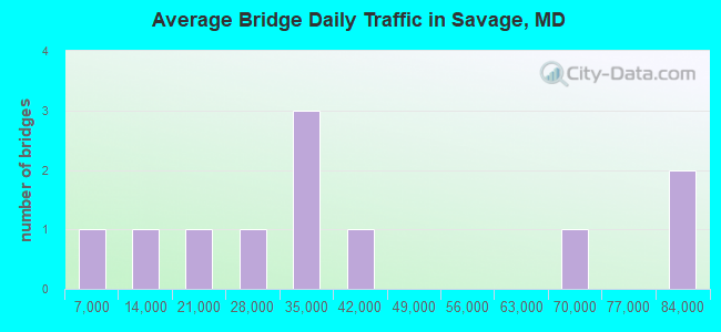
- 415,487Total average daily traffic
- 22,236Total average daily truck traffic
- National Bridge Inventory (NBI) Registered Bridges for Savage
- No street view available for this location
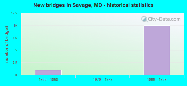
- New bridges - historical statistics
- 11960-1969
- 101980-1989
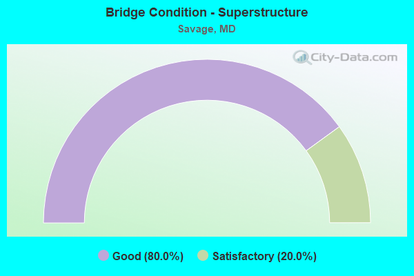
- Bridge Condition - Superstructure
- 80.0%Good
- 20.0%Satisfactory
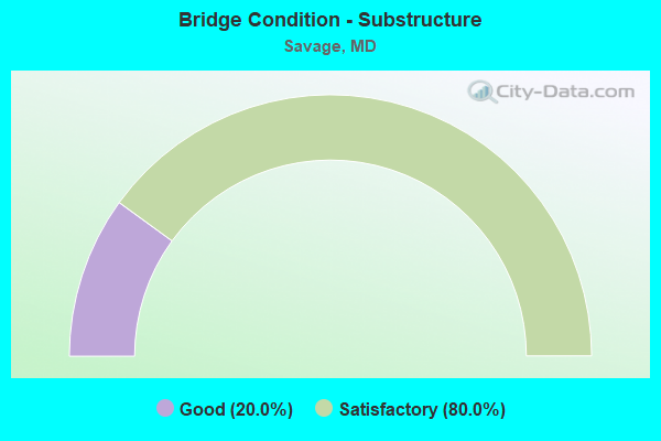
- Bridge Condition - Substructure
- 20.0%Good
- 80.0%Satisfactory
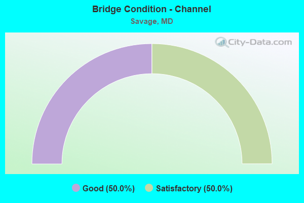
- Bridge Condition - Channel
- 50.0%Good
- 50.0%Satisfactory
Find on map >> Show street view
Structure Number: 10000013009901, Location: 0.85 MILE NORTH OF MD 32 (Lat: 39.149061, Lng: -76.804786), Route carried "on" structure: US 1, Year Built: 1969, Status: Open, Structure Length: 4.24m (13.91ft), Average Daily Traffic: 21,992 (year 2009), Truck Traffic: 8%, Average Future Daily Traffic: 24,031 (year 2026), Design Load: HS 20, Features Intersected: CSX TRANS.
Minimum Vertical Clearance: 30+ m (98+ ft), Kilometerpoint: 5.953, Lanes on structure: 6, Base Highway Network: Yes, Owner: State Highway Agency, Approaching Roadway Width: 20.7m (67.9ft), Material/Design: Steel continuous, Design/Construction: Stringer/Multi-beam, Number Of Spans In Main Unit: 3, Length of Maximum Span: 16.5m (54.1ft), Curb-To-Curb Width: 25.6m (84.0ft), Out-to-Out Width: 26.6m (87.3ft)
Condition: Deck: Satisfactory, Superstructure: Satisfactory, Substructure: Good, Inventory Rating: 59.9 metric tons, Method Used To Determine Inventory Rating: Load Factor (LF), Structural Evaluation: Equal to present minimum criteria, Deck Geometry: Somewhat better than minimum adequacy, Underclear: Equal to present minimum criteria, Approach Roadway Alignment: Equal to present desirable criteria, Designated Inspection Frequency: Every 24 months, Inspection Date: April 2021, Deck Structure Type: Concrete Cast-file-Place, Wearing Surface/Protective System: Wearing Surface: Monolithic Concrete
Find on map >> Show street view
Structure Number: 100000130108013, Location: 1.50 MILES N OF AA CO (Lat: 39.138725, Lng: -76.811858), Route carried "on" structure: State highway 32, Year Built: 1983, Status: Open, Structure Length: 6.77m (22.21ft), Average Daily Traffic: 80,612 (year 2009), Truck Traffic: 8%, Average Future Daily Traffic: 42,380 (year 2026), Design Load: HS 20, Features Intersected: US 1
Minimum Vertical Clearance: 30+ m (98+ ft), Kilometerpoint: 2.383, Lanes on structure: 2, Lanes under structure: 4, Base Highway Network: Yes, Owner: State Highway Agency, Approaching Roadway Width: 12.2m (40.0ft), Material/Design: Steel continuous, Design/Construction: Girder and Floorbeam System, Number Of Spans In Main Unit: 2, Length of Maximum Span: 33.8m (110.9ft), Curb-To-Curb Width: 12.2m (40.0ft), Out-to-Out Width: 13.1m (43.0ft)
Condition: Deck: Satisfactory, Superstructure: Good, Substructure: Satisfactory, Operating Rating: 83.9 metric tons, Method Used To Determine Operating Rating: Load Factor (LF), Inventory Rating: 50.3 metric tons, Method Used To Determine Inventory Rating: Load Factor (LF), Structural Evaluation: Equal to present minimum criteria, Deck Geometry: Better than present minimum criteria, Underclear: Superior to present desirable criteria, Approach Roadway Alignment: Equal to present desirable criteria, Designated Inspection Frequency: Every 24 months, Inspection Date: October 2020, Deck Structure Type: Concrete Cast-file-Place, Wearing Surface/Protective System: Wearing Surface: Monolithic Concrete, Deck Protection: Epoxy Coated Reinforcing
Find on map >> Show street view
Structure Number: 100000130108014, Location: 1.50 MILES N OF AA CO (Lat: 39.138736, Lng: -76.812689), Route carried "on" structure: State highway 32, Year Built: 1983, Status: Open, Structure Length: 6.77m (22.21ft), Average Daily Traffic: 80,612 (year 2009), Truck Traffic: 8%, Average Future Daily Traffic: 42,380 (year 2026), Design Load: HS 20, Features Intersected: US 1
Minimum Vertical Clearance: 30+ m (98+ ft), Kilometerpoint: 2.383, Lanes on structure: 2, Lanes under structure: 4, Base Highway Network: Yes, Owner: State Highway Agency, Approaching Roadway Width: 12.2m (40.0ft), Material/Design: Steel continuous, Design/Construction: Girder and Floorbeam System, Number Of Spans In Main Unit: 2, Length of Maximum Span: 33.8m (110.9ft), Curb-To-Curb Width: 12.2m (40.0ft), Out-to-Out Width: 13.1m (43.0ft)
Condition: Deck: Satisfactory, Superstructure: Good, Substructure: Satisfactory, Operating Rating: 83.9 metric tons, Method Used To Determine Operating Rating: Load Factor (LF), Inventory Rating: 50.3 metric tons, Method Used To Determine Inventory Rating: Load Factor (LF), Structural Evaluation: Equal to present minimum criteria, Deck Geometry: Better than present minimum criteria, Underclear: Superior to present desirable criteria, Approach Roadway Alignment: Equal to present desirable criteria, Designated Inspection Frequency: Every 24 months, Inspection Date: October 2020, Deck Structure Type: Concrete Cast-file-Place, Wearing Surface/Protective System: Wearing Surface: Monolithic Concrete, Deck Protection: Epoxy Coated Reinforcing
Find on map >> Show street view
Structure Number: 10000013010901, Location: 1.50 MILES N OF AA CO (Lat: 39.138878, Lng: -76.811733), Route carried "on" structure: Ramp State highway 32, Year Built: 1983, Status: Open, Structure Length: 6.77m (22.21ft), Average Daily Traffic: 15,788 (year 2006), Truck Traffic: 8%, Average Future Daily Traffic: 18,204 (year 2026), Design Load: HS 20, Features Intersected: US 1
Minimum Vertical Clearance: 30+ m (98+ ft), Kilometerpoint: 0.677, Lanes on structure: 2, Lanes under structure: 4, Base Highway Network: Yes, Owner: State Highway Agency, Approaching Roadway Width: 13.1m (43.0ft), Material/Design: Steel continuous, Design/Construction: Girder and Floorbeam System, Number Of Spans In Main Unit: 2, Length of Maximum Span: 33.8m (110.9ft), Curb-To-Curb Width: 13.1m (43.0ft), Out-to-Out Width: 14.1m (46.3ft)
Condition: Deck: Satisfactory, Superstructure: Good, Substructure: Satisfactory, Operating Rating: 88.4 metric tons, Method Used To Determine Operating Rating: Load Factor (LF), Inventory Rating: 53.1 metric tons, Method Used To Determine Inventory Rating: Load Factor (LF), Structural Evaluation: Equal to present minimum criteria, Deck Geometry: Superior to present desirable criteria, Underclear: Superior to present desirable criteria, Approach Roadway Alignment: Equal to present desirable criteria, Designated Inspection Frequency: Every 24 months, Inspection Date: October 2020, Deck Structure Type: Concrete Cast-file-Place, Wearing Surface/Protective System: Wearing Surface: Monolithic Concrete, Deck Protection: Epoxy Coated Reinforcing
Find on map >> Show street view
Structure Number: 10000013011001, Location: 1.50 MILES N OF AA CO (Lat: 39.138586, Lng: -76.812792), Route carried "on" structure: Ramp State highway 32, Year Built: 1983, Status: Open, Structure Length: 6.77m (22.21ft), Average Daily Traffic: 9,852 (year 2006), Truck Traffic: 8%, Average Future Daily Traffic: 11,359 (year 2026), Design Load: HS 20, Features Intersected: US 1
Minimum Vertical Clearance: 30+ m (98+ ft), Kilometerpoint: 0.579, Lanes on structure: 2, Lanes under structure: 4, Base Highway Network: Yes, Owner: State Highway Agency, Approaching Roadway Width: 13.1m (43.0ft), Material/Design: Steel continuous, Design/Construction: Girder and Floorbeam System, Number Of Spans In Main Unit: 2, Length of Maximum Span: 33.8m (110.9ft), Curb-To-Curb Width: 13.1m (43.0ft), Out-to-Out Width: 14.1m (46.3ft)
Condition: Deck: Satisfactory, Superstructure: Good, Substructure: Satisfactory, Operating Rating: 88.4 metric tons, Method Used To Determine Operating Rating: Load Factor (LF), Inventory Rating: 53.1 metric tons, Method Used To Determine Inventory Rating: Load Factor (LF), Structural Evaluation: Equal to present minimum criteria, Deck Geometry: Superior to present desirable criteria, Underclear: Superior to present desirable criteria, Approach Roadway Alignment: Equal to present desirable criteria, Designated Inspection Frequency: Every 24 months, Inspection Date: October 2020, Deck Structure Type: Concrete Cast-file-Place, Wearing Surface/Protective System: Wearing Surface: Monolithic Concrete, Deck Protection: Epoxy Coated Reinforcing
Find on map >> Show street view
Structure Number: 10000013011302, Location: 0.05 MILE EAST OF US 1 (Lat: 39.140194, Lng: -76.809983), Route carried "on" structure: Ramp State highway 32, Year Built: 1983, Status: Open, Structure Length: 1.89m (6.20ft), Average Daily Traffic: 3,123 (year 2006), Truck Traffic: 8%, Average Future Daily Traffic: 3,601 (year 2026), Design Load: HS 20, Features Intersected: GUILFORD BRANCH
Minimum Vertical Clearance: 30+ m (98+ ft), Kilometerpoint: 0.415, Lanes on structure: 1, Base Highway Network: Yes, Owner: State Highway Agency, Approaching Roadway Width: 8.8m (28.9ft), Skew: 5 degrees, Material/Design: Concrete, Design/Construction: Culvert, Length of Maximum Span: 3.0m (9.8ft)
Condition: Channel: Good, Culverts: Satisfactory, Operating Rating: 32.7 metric tons, Method Used To Determine Operating Rating: Field evaluation and documented engineering judgment, Inventory Rating: 32.7 metric tons, Method Used To Determine Inventory Rating: Field evaluation and documented engineering judgment, Structural Evaluation: Equal to present minimum criteria, Waterway Adequacy: Equal to present desirable criteria, Approach Roadway Alignment: Equal to present desirable criteria, Designated Inspection Frequency: Every 24 months, Inspection Date: July 2021
Find on map >> Show street view
Structure Number: 10000013011602, Location: 0.418 MILE SOUTH OF US 1 (Lat: 39.134908, Lng: -76.805414), Route carried "on" structure: State highway 32, Year Built: 1983, Status: Open, Structure Length: 1.16m (3.81ft), Average Daily Traffic: 66,020 (year 2013), Truck Traffic: 8%, Average Future Daily Traffic: 73,345 (year 2026), Design Load: HS 20, Features Intersected: GUILFORD BRANCH
Minimum Vertical Clearance: 30+ m (98+ ft), Kilometerpoint: 1.741, Lanes on structure: 9, Base Highway Network: Yes, Owner: State Highway Agency, Approaching Roadway Width: 34.1m (111.9ft), Skew: 3 degrees, Material/Design: Concrete, Design/Construction: Culvert, Length of Maximum Span: 3.7m (12.1ft)
Condition: Channel: Satisfactory, Culverts: Satisfactory, Operating Rating: 32.7 metric tons, Method Used To Determine Operating Rating: Field evaluation and documented engineering judgment, Inventory Rating: 32.7 metric tons, Method Used To Determine Inventory Rating: Field evaluation and documented engineering judgment, Structural Evaluation: Equal to present minimum criteria, Waterway Adequacy: Equal to present desirable criteria, Approach Roadway Alignment: Equal to present desirable criteria, Designated Inspection Frequency: Every 24 months, Inspection Date: July 2021
Find on map >> Show street view
Structure Number: 100000130108013, Location: 0.25 M N OF HOWARD STREET (Lat: 39.138725, Lng: -76.811858), Route carried "under" structure: US 1, Year Built: 1983, Structure Length: 0. m, Average Daily Traffic: 33,812 (year 2009), Features Intersected: US 1, Facility Carried by Structure: MD 32 EBR
Minimum Vertical Clearance: 5.18m (16.99ft), Kilometerpoint: 4.586, Lanes on structure: 2, Lanes under structure: 4, Material/Design: Steel continuous, Design/Construction: Girder and Floorbeam System, Length of Maximum Span: 33.8m (110.9ft)
Find on map >> Show street view
Structure Number: 100000130108014, Location: 0.25 M N OF HOWARD STREET (Lat: 39.138736, Lng: -76.812689), Route carried "under" structure: US 1, Year Built: 1983, Structure Length: 0. m, Average Daily Traffic: 33,812 (year 2009), Features Intersected: US 1, Facility Carried by Structure: MD 32 WBR
Minimum Vertical Clearance: 5.18m (16.99ft), Kilometerpoint: 4.586, Lanes on structure: 2, Lanes under structure: 4, Material/Design: Steel continuous, Design/Construction: Girder and Floorbeam System, Length of Maximum Span: 33.8m (110.9ft)
Find on map >> Show street view
Structure Number: 10000013010901, Location: 0.28 M N OF HOWARD STREET (Lat: 39.138878, Lng: -76.811733), Route carried "under" structure: US 1, Year Built: 1983, Structure Length: 0. m, Average Daily Traffic: 33,812 (year 2009), Features Intersected: US 1, Facility Carried by Structure: MD 32 WB COLLEC.RD
Minimum Vertical Clearance: 5.18m (16.99ft), Kilometerpoint: 4.634, Lanes on structure: 2, Lanes under structure: 4, Material/Design: Steel continuous, Design/Construction: Girder and Floorbeam System, Length of Maximum Span: 33.8m (110.9ft)
Find on map >> Show street view
Structure Number: 10000013011001, Location: 0.22 M N OF HOWARD STREET (Lat: 39.138586, Lng: -76.812792), Route carried "under" structure: US 1, Year Built: 1983, Structure Length: 0. m, Average Daily Traffic: 36,052 (year 2009), Features Intersected: US 1, Facility Carried by Structure: MD 32 EB COLLEC.RD
Minimum Vertical Clearance: 5.18m (16.99ft), Kilometerpoint: 4.537, Lanes on structure: 2, Lanes under structure: 4, Material/Design: Steel continuous, Design/Construction: Girder and Floorbeam System, Length of Maximum Span: 33.8m (110.9ft)