Bridge Statistics for Saranac, Michigan (MI)
Condition, Traffic, Stress, Structural Evaluation, Project Costs
- National Bridge Inventory (NBI) Statistics
- 10Number of bridges
- 85ft / 25.8mTotal length
- 25,940Total average daily traffic
- 1,275Total average daily truck traffic
- 33,585Total future (year 2018) average daily traffic
- National Bridge Inventory (NBI) Registered Bridges for Saranac
- No street view available for this location
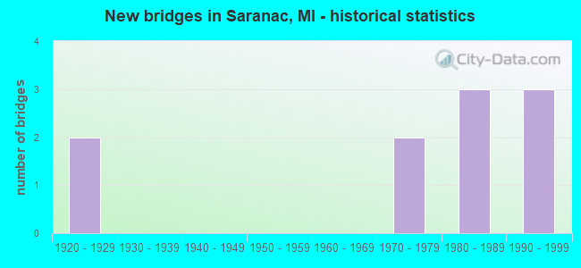
- New bridges - historical statistics
- 21920-1929
- 21970-1979
- 31980-1989
- 31990-1999


- Bridge Condition - Deck
- 57.1%Good
- 42.9%Satisfactory

- Bridge Condition - Superstructure
- 28.6%Very good
- 14.3%Good
- 42.9%Satisfactory
- 14.3%Fair

- Bridge Condition - Substructure
- 42.9%Very good
- 28.6%Good
- 14.3%Satisfactory
- 14.3%Fair

- Bridge Condition - Channel
- 10.0%Very good
- 20.0%Good
- 40.0%Satisfactory
- 30.0%Fair

- Bridge Condition - Culverts
- 66.7%Good
- 33.3%Poor
Find on map >> Show street view
Structure Number: 4002, Location: 2.6 MI E OF KENT CO LINE (Lat: 42.933428, Lng: -85.260289), Route carried "on" structure: State highway 21, Year Built: 1929, Status: Open, Structure Length: 0.79m (2.59ft), Average Daily Traffic: 5,100 (year 2008), Truck Traffic: 5%, Average Future Daily Traffic: 6,700 (year 2032), Design Load: H 15, Features Intersected: TOLES CREEK
Minimum Vertical Clearance: 30.48m (100.00ft), Kilometerpoint: 4.260, Lanes on structure: 2, Base Highway Network: Yes (Inventory Route: 50, Subroute: 4), Owner: State Highway Agency, Approaching Roadway Width: 12.2m (40.0ft), Material/Design: Concrete continuous, Design/Construction: Culvert, Number Of Spans In Main Unit: 2, Length of Maximum Span: 3.9m (12.8ft), Curb-To-Curb Width: 10.7m (35.1ft), Out-to-Out Width: 11.5m (37.7ft)
Condition: Channel: Fair, Culverts: Good, Operating Rating: 59.6 metric tons, Method Used To Determine Operating Rating: Load Factor (LF) rating reported by rating factor (RF) method using MS18 loading, Inventory Rating: 35.6 metric tons, Method Used To Determine Inventory Rating: Load Factor (LF) rating reported by rating factor (RF) method using MS18 loading, Structural Evaluation: Better than present minimum criteria, Deck Geometry: Meets minimum limits, Waterway Adequacy: Equal to present desirable criteria, Approach Roadway Alignment: Better than present minimum criteria, Designated Inspection Frequency: Every 24 months, Inspection Date: December 2020
Find on map >> Show street view
Structure Number: 4003, Location: 6.3 MI E OF KENT CO LINE (Lat: 42.946186, Lng: -85.190756), Route carried "on" structure: State highway 21, Year Built: 1929, Status: Open, Structure Length: 0.98m (3.22ft), Average Daily Traffic: 5,896 (year 2007), Truck Traffic: 5%, Average Future Daily Traffic: 8,880 (year 2018), Design Load: H 15, Features Intersected: RED CREEK
Minimum Vertical Clearance: 30.48m (100.00ft), Kilometerpoint: 10.271, Lanes on structure: 2, Base Highway Network: Yes (Inventory Route: 50, Subroute: 4), Owner: State Highway Agency, Approaching Roadway Width: 12.2m (40.0ft), Material/Design: Concrete continuous, Design/Construction: Culvert, Number Of Spans In Main Unit: 2, Length of Maximum Span: 4.8m (15.7ft), Out-to-Out Width: 11.5m (37.7ft)
Condition: Channel: Satisfactory, Culverts: Good, Operating Rating: 76.1 metric tons, Method Used To Determine Operating Rating: Load Factor (LF) rating reported by rating factor (RF) method using MS18 loading, Inventory Rating: 45.7 metric tons, Method Used To Determine Inventory Rating: Load Factor (LF) rating reported by rating factor (RF) method using MS18 loading, Structural Evaluation: Better than present minimum criteria, Waterway Adequacy: Better than present minimum criteria, Approach Roadway Alignment: Equal to present minimum criteria, Designated Inspection Frequency: Every 24 months, Inspection Date: December 2020
Find on map >> Show street view
Structure Number: 4053, Location: 1.0 MILE SOUTH OF SARANAC (Lat: 42.911292, Lng: -85.213914), Route carried "on" structure: ServiceCounty highway , Year Built: 1997, Status: Open, Structure Length: 1.98m (6.50ft), Average Daily Traffic: 250 (year 2008), Truck Traffic: 8%, Average Future Daily Traffic: 291 (year 2028), Design Load: HS 20+Mod, Features Intersected: LAKE CREEK, Facility Carried by Structure: MACARTHUR ROAD
Minimum Vertical Clearance: 30.48m (100.00ft), Kilometerpoint: 4.587, Lanes on structure: 2, Owner: County Highway Agency, Approaching Roadway Width: 9.1m (29.9ft), Material/Design: Prestressed concrete, Design/Construction: Box Beam or Girders - Multiple, Number Of Spans In Main Unit: 1, Length of Maximum Span: 18.6m (61.0ft), Curb-To-Curb Width: 9.1m (29.9ft), Out-to-Out Width: 9.5m (31.2ft)
Condition: Deck: Good, Superstructure: Good, Substructure: Very good, Channel: Satisfactory, Operating Rating: 77.4 metric tons, Method Used To Determine Operating Rating: Load Factor (LF) rating reported by rating factor (RF) method using MS18 loading, Inventory Rating: 46.3 metric tons, Method Used To Determine Inventory Rating: Load Factor (LF) rating reported by rating factor (RF) method using MS18 loading, Structural Evaluation: Better than present minimum criteria, Deck Geometry: Equal to present minimum criteria, Waterway Adequacy: Better than present minimum criteria, Approach Roadway Alignment: Somewhat better than minimum adequacy, Designated Inspection Frequency: Every 24 months, Inspection Date: October 2020, Deck Structure Type: Concrete Cast-file-Place, Wearing Surface/Protective System: Wearing Surface: Monolithic Concrete, Deck Protection: Epoxy Coated Reinforcing
Find on map >> Show street view
Structure Number: 4054, Location: 1.5 MILES SOUTH OF SARANA (Lat: 42.900522, Lng: -85.215342), Route carried "on" structure: ServiceCounty highway , Year Built: 1973, Status: Posted for load, Structure Length: 0.79m (2.59ft), Average Daily Traffic: 297 (year 2006), Truck Traffic: 4%, Average Future Daily Traffic: 346 (year 2028), Design Load: HS 20+Mod, Features Intersected: LAKE CREEK, Facility Carried by Structure: PECK LAKE ROAD
Minimum Vertical Clearance: 30.48m (100.00ft), Kilometerpoint: 7.886, Lanes on structure: 2, Owner: County Highway Agency, Approaching Roadway Width: 7.3m (24.0ft), Material/Design: Wood or Timber, Design/Construction: Slab, Number Of Spans In Main Unit: 1, Length of Maximum Span: 7.6m (24.9ft), Curb-To-Curb Width: 9.1m (29.9ft), Out-to-Out Width: 9.6m (31.5ft)
Condition: Deck: Satisfactory, Superstructure: Satisfactory, Substructure: Fair, Channel: Fair, Operating Rating: 39.9 metric tons, Method Used To Determine Operating Rating: Allowable Stress (AS) rating reported by rating factor (RF) method using MS18 loading, Inventory Rating: 27.5 metric tons, Method Used To Determine Inventory Rating: Allowable Stress (AS) rating reported by rating factor (RF) method using MS18 loading, Structural Evaluation: Somewhat better than minimum adequacy, Deck Geometry: Equal to present minimum criteria, Waterway Adequacy: Better than present minimum criteria, Approach Roadway Alignment: Equal to present minimum criteria, Bridge Posting: Required (Relationship of Operating Rating to Maximum Legal Load: 10.0 - 19.9% below), Designated Inspection Frequency: Every 24 months, Inspection Date: October 2020, Deck Structure Type: Wood or Timber, Wearing Surface/Protective System: Wearing Surface: Bituminous
Find on map >> Show street view
Structure Number: 4055, Location: 1.0 MILE SE OF SARANAC (Lat: 42.915361, Lng: -85.193533), Route carried "on" structure: ServiceCounty highway , Year Built: 1993, Status: Open, Structure Length: 0.67m (2.20ft), Average Daily Traffic: 321 (year 2008), Truck Traffic: 10%, Average Future Daily Traffic: 373 (year 2028), Design Load: HS 20+Mod, Features Intersected: UNNAMED CREEK, Facility Carried by Structure: JACKSON ROAD
Minimum Vertical Clearance: 30.48m (100.00ft), Kilometerpoint: 3.945, Lanes on structure: 2, Owner: County Highway Agency, Approaching Roadway Width: 6.1m (20.0ft), Skew: 2 degrees, Material/Design: Steel, Design/Construction: Culvert, Number Of Spans In Main Unit: 2, Length of Maximum Span: 3.0m (9.8ft)
Condition: Channel: Fair, Culverts: Poor, Operating Rating: 60.9 metric tons, Method Used To Determine Operating Rating: Load Factor (LF) rating reported by rating factor (RF) method using MS18 loading, Inventory Rating: 36.6 metric tons, Method Used To Determine Inventory Rating: Load Factor (LF) rating reported by rating factor (RF) method using MS18 loading, Structural Evaluation: Meets minimum limits, Waterway Adequacy: Equal to present minimum criteria, Approach Roadway Alignment: Equal to present minimum criteria, Designated Inspection Frequency: Every 12 months, Inspection Date: October 2021, Wearing Surface/Protective System: Wearing Surface: Gravel
Find on map >> Show street view
Structure Number: 4106, Location: IN SARANAC (Lat: 42.928581, Lng: -85.213497), Route carried "on" structure: City street 3444, Year Built: 1995, Status: Open, Structure Length: 1.68m (5.51ft), Average Daily Traffic: 777 (year 2003), Average Future Daily Traffic: 860 (year 2023), Design Load: HS 20+Mod, Features Intersected: LAKE CREEK, Facility Carried by Structure: SUMMIT STREET
Minimum Vertical Clearance: 30.48m (100.00ft), Kilometerpoint: 8.232, Lanes on structure: 2, Owner: City or Municipal Highway Agency, Approaching Roadway Width: 9.1m (29.9ft), Material/Design: Prestressed concrete, Design/Construction: Box Beam or Girders - Multiple, Number Of Spans In Main Unit: 1, Length of Maximum Span: 16.4m (53.8ft), Curb or Sidewalk Widths: Left: 1.8m (5.9ft), Right: 1.8m (5.9ft), Curb-To-Curb Width: 9.1m (29.9ft), Out-to-Out Width: 13.6m (44.6ft)
Condition: Deck: Good, Superstructure: Very good, Substructure: Good, Channel: Good, Operating Rating: 90.4 metric tons, Method Used To Determine Operating Rating: Load Factor (LF) rating reported by rating factor (RF) method using MS18 loading, Inventory Rating: 54.1 metric tons, Method Used To Determine Inventory Rating: Load Factor (LF) rating reported by rating factor (RF) method using MS18 loading, Structural Evaluation: Better than present minimum criteria, Deck Geometry: Equal to present minimum criteria, Waterway Adequacy: Equal to present desirable criteria, Approach Roadway Alignment: Equal to present desirable criteria, Designated Inspection Frequency: Every 24 months, Inspection Date: September 2021, Deck Structure Type: Concrete Cast-file-Place, Wearing Surface/Protective System: Wearing Surface: Monolithic Concrete, Deck Protection: Epoxy Coated Reinforcing
Find on map >> Show street view
Structure Number: 4107, Location: IN SARANAC (Lat: 42.928431, Lng: -85.213217), Route carried "on" structure: City street 3415, Year Built: 1987, Status: Open, Structure Length: 1.52m (4.99ft), Average Daily Traffic: 1,333 (year 2003), Truck Traffic: 5%, Average Future Daily Traffic: 1,550 (year 2023), Design Load: HS 20+Mod, Features Intersected: LAKE CREEK, Facility Carried by Structure: SOUTH BRIDGE ST S
Minimum Vertical Clearance: 30.48m (100.00ft), Kilometerpoint: 7.384, Lanes on structure: 2, Owner: City or Municipal Highway Agency, Approaching Roadway Width: 6.1m (20.0ft), Skew: 2 degrees, Material/Design: Prestressed concrete, Design/Construction: Box Beam or Girders - Multiple, Number Of Spans In Main Unit: 1, Length of Maximum Span: 14.5m (47.6ft), Curb-To-Curb Width: 12.5m (41.0ft), Out-to-Out Width: 13.3m (43.6ft)
Condition: Deck: Good, Superstructure: Fair, Substructure: Very good, Channel: Satisfactory, Operating Rating: 64.8 metric tons, Method Used To Determine Operating Rating: Load Factor (LF) rating reported by rating factor (RF) method using MS18 loading, Inventory Rating: 38.9 metric tons, Method Used To Determine Inventory Rating: Load Factor (LF) rating reported by rating factor (RF) method using MS18 loading, Structural Evaluation: Somewhat better than minimum adequacy, Deck Geometry: Better than present minimum criteria, Waterway Adequacy: Equal to present desirable criteria, Approach Roadway Alignment: Equal to present desirable criteria, Designated Inspection Frequency: Every 24 months, Inspection Date: September 2021, Deck Structure Type: Concrete Precast Panels, Wearing Surface/Protective System: Wearing Surface: Bituminous, Membrane: Preformed Fabric, Deck Protection: Epoxy Coated Reinforcing
Find on map >> Show street view
Structure Number: 4108, Location: IN SARANAC (Lat: 42.925208, Lng: -85.213131), Route carried "on" structure: City street 3415, Year Built: 1987, Status: Open, Structure Length: 1.52m (4.99ft), Average Daily Traffic: 1,333 (year 2003), Truck Traffic: 5%, Average Future Daily Traffic: 1,550 (year 2023), Design Load: HS 20+Mod, Features Intersected: LAKE CREEK, Facility Carried by Structure: SOUTH BRIDGE ST N
Minimum Vertical Clearance: 30.48m (100.00ft), Kilometerpoint: 7.025, Lanes on structure: 2, Owner: City or Municipal Highway Agency, Approaching Roadway Width: 6.1m (20.0ft), Skew: 2 degrees, Material/Design: Prestressed concrete, Design/Construction: Box Beam or Girders - Multiple, Number Of Spans In Main Unit: 1, Length of Maximum Span: 14.5m (47.6ft), Curb-To-Curb Width: 12.5m (41.0ft), Out-to-Out Width: 13.3m (43.6ft)
Condition: Deck: Satisfactory, Superstructure: Satisfactory, Substructure: Very good, Channel: Good, Operating Rating: 64.8 metric tons, Method Used To Determine Operating Rating: Load Factor (LF) rating reported by rating factor (RF) method using MS18 loading, Inventory Rating: 38.9 metric tons, Method Used To Determine Inventory Rating: Load Factor (LF) rating reported by rating factor (RF) method using MS18 loading, Structural Evaluation: Equal to present minimum criteria, Deck Geometry: Better than present minimum criteria, Waterway Adequacy: Equal to present desirable criteria, Approach Roadway Alignment: Equal to present desirable criteria, Designated Inspection Frequency: Every 24 months, Inspection Date: September 2021, Deck Structure Type: Concrete Precast Panels, Wearing Surface/Protective System: Wearing Surface: Bituminous, Membrane: Preformed Fabric
Find on map >> Show street view
Structure Number: 4109, Location: 0.32 M S M21 IN SARANAC (Lat: 42.932683, Lng: -85.213331), Route carried "on" structure: County highway 3415, Year Built: 1977, Status: Posted for load, Structure Length: 14.11m (46.29ft), Average Daily Traffic: 7,300 (year 2017), Truck Traffic: 5%, Average Future Daily Traffic: 8,300 (year 2037), Design Load: HS 20+Mod, Features Intersected: GRAND RIVER-CHANNEL, Facility Carried by Structure: NORTH BRIDGE ST
Minimum Vertical Clearance: 30.48m (100.00ft), Kilometerpoint: 7.855, Lanes on structure: 2, Owner: City or Municipal Highway Agency, Approaching Roadway Width: 11.9m (39.0ft), Material/Design: Prestressed concrete, Design/Construction: Box Beam or Girders - Multiple, Number Of Spans In Main Unit: 6, Length of Maximum Span: 23.2m (76.1ft), Curb or Sidewalk Widths: Left: 1.5m (4.9ft), Right: 1.5m (4.9ft), Curb-To-Curb Width: 8.5m (27.9ft), Out-to-Out Width: 12.3m (40.4ft)
Condition: Deck: Satisfactory, Superstructure: Satisfactory, Substructure: Satisfactory, Channel: Satisfactory, Operating Rating: 54.1 metric tons, Method Used To Determine Operating Rating: Load Factor (LF) rating reported by rating factor (RF) method using MS18 loading, Inventory Rating: 32.4 metric tons, Method Used To Determine Inventory Rating: Load Factor (LF) rating reported by rating factor (RF) method using MS18 loading, Structural Evaluation: Equal to present minimum criteria, Deck Geometry: Meets minimum limits, Waterway Adequacy: Equal to present desirable criteria, Approach Roadway Alignment: Better than present minimum criteria, Bridge Posting: Required (Relationship of Operating Rating to Maximum Legal Load: 0.1 - 9.9% below), Designated Inspection Frequency: Every 24 months, Inspection Date: September 2021, Deck Structure Type: Concrete Precast Panels, Wearing Surface/Protective System: Wearing Surface: Bituminous, Membrane: Preformed Fabric
Find on map >> Show street view
Structure Number: 411, Location: IN SARANAC (Lat: 42.929506, Lng: -85.215161), Route carried "on" structure: City street , Year Built: 1986, Status: Posted for load, Structure Length: 1.77m (5.81ft), Average Daily Traffic: 3,333 (year 2003), Truck Traffic: 5%, Average Future Daily Traffic: 4,735 (year 2023), Design Load: HS 20+Mod, Features Intersected: LAKE CREEK, Facility Carried by Structure: DIVISION STREET
Minimum Vertical Clearance: 30.48m (100.00ft), Kilometerpoint: 0.246, Lanes on structure: 2, Owner: City or Municipal Highway Agency, Approaching Roadway Width: 6.1m (20.0ft), Material/Design: Prestressed concrete, Design/Construction: Box Beam or Girders - Multiple, Number Of Spans In Main Unit: 1, Length of Maximum Span: 17.1m (56.1ft), Curb or Sidewalk Widths: Left: 0.0m, Right: 1.5m (4.9ft), Curb-To-Curb Width: 8.5m (27.9ft), Out-to-Out Width: 11.0m (36.1ft)
Condition: Deck: Good, Superstructure: Very good, Substructure: Good, Channel: Very good, Operating Rating: 48.6 metric tons, Method Used To Determine Operating Rating: Load Factor (LF) rating reported by rating factor (RF) method using MS18 loading, Inventory Rating: 29.2 metric tons, Method Used To Determine Inventory Rating: Load Factor (LF) rating reported by rating factor (RF) method using MS18 loading, Structural Evaluation: Better than present minimum criteria, Deck Geometry: Meets minimum limits, Waterway Adequacy: Equal to present desirable criteria, Approach Roadway Alignment: Equal to present desirable criteria, Bridge Posting: Required (Relationship of Operating Rating to Maximum Legal Load: 0.1 - 9.9% below), Designated Inspection Frequency: Every 24 months, Inspection Date: September 2021, Deck Structure Type: Concrete Precast Panels, Wearing Surface/Protective System: Wearing Surface: Bituminous, Membrane: Preformed Fabric