Bridge Statistics for Santee, South Carolina (SC)
Condition, Traffic, Stress, Structural Evaluation, Project Costs
- National Bridge Inventory (NBI) Statistics
- 22Number of bridges
- 1,145ft / 349mTotal length
- 282,075Total average daily traffic
- 53,909Total average daily truck traffic
- National Bridge Inventory (NBI) Registered Bridges for Santee
- No street view available for this location
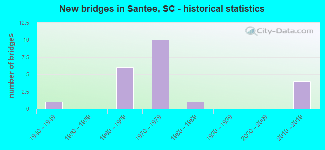
- New bridges - historical statistics
- 11940-1949
- 61960-1969
- 101970-1979
- 11980-1989
- 42010-2019


- Bridge Condition - Deck
- 14.3%Very good
- 28.6%Good
- 42.9%Satisfactory
- 14.3%Fair

- Bridge Condition - Superstructure
- 14.3%Very good
- 50.0%Good
- 28.6%Satisfactory
- 7.1%Fair

- Bridge Condition - Substructure
- 35.7%Very good
- 14.3%Good
- 35.7%Satisfactory
- 14.3%Fair

- Bridge Condition - Channel
- 30.0%Very good
- 50.0%Good
- 10.0%Satisfactory
- 10.0%Fair

- Bridge Condition - Culverts
- 50.0%Good
- 50.0%Satisfactory
Find on map >> Show street view
Structure Number: 1894, Location: 3MI E ELLOREE (Lat: 33.523128, Lng: -80.513731), Route carried "on" structure: State highway 105, Year Built: 2013, Status: Open, Structure Length: 2.26m (7.41ft), Average Daily Traffic: 800 (year 2020), Truck Traffic: 5%, Average Future Daily Traffic: 1,168 (year 2040), Design Load: HL 93, Features Intersected: SPILLWAY - BROWNING
Minimum Vertical Clearance: 30+ m (98+ ft), Kilometerpoint: 7.025, Lanes on structure: 2, Owner: State Highway Agency, Approaching Roadway Width: 8.6m (28.2ft), Material/Design: Concrete, Design/Construction: Slab, Number Of Spans In Main Unit: 1, Number Of Approach Spans: 2, Length of Maximum Span: 9.1m (29.9ft), Curb-To-Curb Width: 10.4m (34.1ft), Out-to-Out Width: 11.4m (37.4ft)
Condition: Deck: Good, Superstructure: Good, Substructure: Very good, Channel: Very good, Operating Rating: 53.8 metric tons, Method Used To Determine Operating Rating: Load and Resistance Factor Rating (LRFR) rating reported by rating factor(RF) method using HL-93 loadings, Inventory Rating: 41.5 metric tons, Method Used To Determine Inventory Rating: Load and Resistance Factor Rating (LRFR) rating reported by rating factor(RF) method using HL-93 loadings, Structural Evaluation: Better than present minimum criteria, Deck Geometry: Equal to present minimum criteria, Waterway Adequacy: Equal to present desirable criteria, Approach Roadway Alignment: Better than present minimum criteria, Length Of Structure Improvement: 2.26m (7.41ft), Designated Inspection Frequency: Every 24 months, Inspection Date: November 2020, Deck Structure Type: Concrete Cast-file-Place, Wearing Surface/Protective System: Wearing Surface: Monolithic Concrete
Find on map >> Show street view
Structure Number: 5135, Location: .25MI E OF SANTEE (Lat: 33.485000, Lng: -80.470278), Route carried "on" structure: State highway 6, Year Built: 1967, Status: Open, Structure Length: 7.80m (25.59ft), Average Daily Traffic: 11,300 (year 2021), Truck Traffic: 6%, Average Future Daily Traffic: 17,967 (year 2041), Design Load: HS 20, Features Intersected: I-95
Minimum Vertical Clearance: 30+ m (98+ ft), Kilometerpoint: 15.315, Lanes on structure: 2, Lanes under structure: 4, Base Highway Network: Yes, Owner: State Highway Agency, Approaching Roadway Width: 8.5m (27.9ft), Skew: 1 degrees, Material/Design: Prestressed concrete, Design/Construction: Stringer/Multi-beam, Number Of Spans In Main Unit: 4, Length of Maximum Span: 22.6m (74.1ft), Curb or Sidewalk Widths: Left: 1.2m (3.9ft), Right: 1.2m (3.9ft), Curb-To-Curb Width: 8.5m (27.9ft), Out-to-Out Width: 11.4m (37.4ft)
Condition: Deck: Good, Superstructure: Good, Substructure: Good, Operating Rating: 58.3 metric tons, Method Used To Determine Operating Rating: Load and Resistance Factor Rating (LRFR) rating reported by rating factor(RF) method using HL-93 loadings, Inventory Rating: 29.5 metric tons, Method Used To Determine Inventory Rating: Load and Resistance Factor Rating (LRFR) rating reported by rating factor(RF) method using HL-93 loadings, Structural Evaluation: Better than present minimum criteria, Deck Geometry: Meets minimum limits, Underclear: High priority of corrective action, Approach Roadway Alignment: Equal to present desirable criteria, Length Of Structure Improvement: 7.80m (25.59ft), Designated Inspection Frequency: Every 24 months, Inspection Date: December 2021, Deck Structure Type: Concrete Cast-file-Place, Wearing Surface/Protective System: Wearing Surface: Bituminous
Find on map >> Show street view
Structure Number: 5249, Location: 7MI S OF SUMMERTON (Lat: 33.505186, Lng: -80.452475), Route carried "on" structure: Interstate 95, Year Built: 1968, Status: Open, Structure Length: 137.16m (450.00ft), Average Daily Traffic: 19,450 (year 2021), Truck Traffic: 22%, Average Future Daily Traffic: 34,038 (year 2041), Design Load: HS 20, Features Intersected: LAKE MARION
Minimum Vertical Clearance: 30+ m (98+ ft), Kilometerpoint: 160.281, Lanes on structure: 2, Base Highway Network: Yes, Owner: State Highway Agency, Approaching Roadway Width: 11.6m (38.1ft), Navigation Control: Yes ( Vertical Clearance: 15.2m (49.9ft), Horizontal Clearance: 30.5m (100.1ft)), Material/Design: Steel continuous, Design/Construction: Stringer/Multi-beam, Number Of Spans In Main Unit: 5, Number Of Approach Spans: 80, Length of Maximum Span: 42.7m (140.1ft), Curb-To-Curb Width: 9.4m (30.8ft), Out-to-Out Width: 10.7m (35.1ft)
Condition: Deck: Fair, Superstructure: Fair, Substructure: Fair, Channel: Satisfactory, Operating Rating: 35.6 metric tons, Method Used To Determine Operating Rating: Load and Resistance Factor Rating (LRFR) rating reported by rating factor(RF) method using HL-93 loadings, Inventory Rating: 22.4 metric tons, Method Used To Determine Inventory Rating: Load and Resistance Factor Rating (LRFR) rating reported by rating factor(RF) method using HL-93 loadings, Structural Evaluation: Somewhat better than minimum adequacy, Deck Geometry: Meets minimum limits, Waterway Adequacy: Equal to present minimum criteria, Approach Roadway Alignment: Equal to present desirable criteria, Length Of Structure Improvement: 137.16m (450.00ft), Designated Inspection Frequency: Every 24 months, Underwater Inspection Frequency: Every 60 months, Inspection Date: October 2021, Underwater Inspection Date: Febuary 2021, Deck Structure Type: Concrete Cast-file-Place, Wearing Surface/Protective System: Wearing Surface: Monolithic Concrete
Find on map >> Show street view
Structure Number: 525, Location: 7MI S OF SUMMERTON (Lat: 33.518133, Lng: -80.435556), Route carried "on" structure: Interstate 95, Year Built: 1968, Status: Open, Structure Length: 10.97m (35.99ft), Average Daily Traffic: 16,500 (year 2020), Truck Traffic: 16%, Average Future Daily Traffic: 28,875 (year 2040), Design Load: HS 20, Features Intersected: LAKE MARION RELIEF
Minimum Vertical Clearance: 30+ m (98+ ft), Kilometerpoint: 162.943, Lanes on structure: 2, Base Highway Network: Yes, Owner: State Highway Agency, Approaching Roadway Width: 11.6m (38.1ft), Material/Design: Concrete, Design/Construction: Tee Beam, Number Of Spans In Main Unit: 9, Length of Maximum Span: 12.2m (40.0ft), Curb-To-Curb Width: 9.4m (30.8ft), Out-to-Out Width: 10.7m (35.1ft)
Condition: Deck: Satisfactory, Superstructure: Satisfactory, Substructure: Satisfactory, Channel: Good, Operating Rating: 60.3 metric tons, Method Used To Determine Operating Rating: Load and Resistance Factor Rating (LRFR) rating reported by rating factor(RF) method using HL-93 loadings, Inventory Rating: 46.3 metric tons, Method Used To Determine Inventory Rating: Load and Resistance Factor Rating (LRFR) rating reported by rating factor(RF) method using HL-93 loadings, Structural Evaluation: Equal to present minimum criteria, Deck Geometry: Meets minimum limits, Waterway Adequacy: Equal to present minimum criteria, Approach Roadway Alignment: Equal to present desirable criteria, Length Of Structure Improvement: 10.97m (35.99ft), Designated Inspection Frequency: Every 24 months, Underwater Inspection Frequency: Every 60 months, Inspection Date: October 2021, Underwater Inspection Date: Febuary 2021, Deck Structure Type: Concrete Cast-file-Place, Wearing Surface/Protective System: Wearing Surface: Monolithic Concrete
Find on map >> Show street view
Structure Number: 5258, Location: 7MI S OF SUMMERTON (Lat: 33.505347, Lng: -80.452739), Route carried "on" structure: Interstate 95, Year Built: 1968, Status: Open, Structure Length: 137.16m (450.00ft), Average Daily Traffic: 16,500 (year 2020), Truck Traffic: 16%, Average Future Daily Traffic: 28,875 (year 2040), Design Load: HS 20, Features Intersected: LAKE MARION
Minimum Vertical Clearance: 30+ m (98+ ft), Kilometerpoint: 160.291, Lanes on structure: 2, Base Highway Network: Yes, Owner: State Highway Agency, Approaching Roadway Width: 11.6m (38.1ft), Navigation Control: Yes ( Vertical Clearance: 15.2m (49.9ft), Horizontal Clearance: 30.5m (100.1ft)), Material/Design: Steel continuous, Design/Construction: Stringer/Multi-beam, Number Of Spans In Main Unit: 5, Number Of Approach Spans: 80, Length of Maximum Span: 42.7m (140.1ft), Curb-To-Curb Width: 9.4m (30.8ft), Out-to-Out Width: 10.7m (35.1ft)
Condition: Deck: Fair, Superstructure: Satisfactory, Substructure: Fair, Channel: Very good, Operating Rating: 34.3 metric tons, Method Used To Determine Operating Rating: Load and Resistance Factor Rating (LRFR) rating reported by rating factor(RF) method using HL-93 loadings, Inventory Rating: 22.4 metric tons, Method Used To Determine Inventory Rating: Load and Resistance Factor Rating (LRFR) rating reported by rating factor(RF) method using HL-93 loadings, Structural Evaluation: Somewhat better than minimum adequacy, Deck Geometry: Meets minimum limits, Waterway Adequacy: Equal to present minimum criteria, Approach Roadway Alignment: Equal to present desirable criteria, Length Of Structure Improvement: 137.16m (450.00ft), Designated Inspection Frequency: Every 24 months, Underwater Inspection Frequency: Every 60 months, Inspection Date: October 2021, Underwater Inspection Date: Febuary 2021, Deck Structure Type: Concrete Cast-file-Place, Wearing Surface/Protective System: Wearing Surface: Monolithic Concrete
Find on map >> Show street view
Structure Number: 5259, Location: 7MI S OF SUMMERTON (Lat: 33.518325, Lng: -80.435778), Route carried "on" structure: Interstate 95, Year Built: 1968, Status: Open, Structure Length: 10.97m (35.99ft), Average Daily Traffic: 16,500 (year 2020), Truck Traffic: 16%, Average Future Daily Traffic: 28,875 (year 2040), Design Load: HS 20, Features Intersected: LAKE MARION RELIEF
Minimum Vertical Clearance: 30+ m (98+ ft), Kilometerpoint: 162.941, Lanes on structure: 2, Base Highway Network: Yes, Owner: State Highway Agency, Approaching Roadway Width: 11.6m (38.1ft), Material/Design: Concrete, Design/Construction: Tee Beam, Number Of Spans In Main Unit: 9, Length of Maximum Span: 12.2m (40.0ft), Curb-To-Curb Width: 9.4m (30.8ft), Out-to-Out Width: 10.7m (35.1ft)
Condition: Deck: Satisfactory, Superstructure: Satisfactory, Substructure: Satisfactory, Channel: Good, Operating Rating: 60.3 metric tons, Method Used To Determine Operating Rating: Load and Resistance Factor Rating (LRFR) rating reported by rating factor(RF) method using HL-93 loadings, Inventory Rating: 46.3 metric tons, Method Used To Determine Inventory Rating: Load and Resistance Factor Rating (LRFR) rating reported by rating factor(RF) method using HL-93 loadings, Structural Evaluation: Equal to present minimum criteria, Deck Geometry: Meets minimum limits, Waterway Adequacy: Equal to present desirable criteria, Approach Roadway Alignment: Equal to present desirable criteria, Length Of Structure Improvement: 10.97m (35.99ft), Designated Inspection Frequency: Every 24 months, Underwater Inspection Frequency: Every 60 months, Inspection Date: October 2021, Underwater Inspection Date: Febuary 2021, Deck Structure Type: Concrete Cast-file-Place, Wearing Surface/Protective System: Wearing Surface: Monolithic Concrete
Find on map >> Show street view
Structure Number: 5826, Location: 1 MI SE OF SANTEE (Lat: 33.473667, Lng: -80.475222), Route carried "on" structure: Interstate 95, Year Built: 1970, Status: Open, Structure Length: 6.71m (22.01ft), Average Daily Traffic: 18,850 (year 2021), Truck Traffic: 21%, Average Future Daily Traffic: 32,988 (year 2041), Design Load: HS 20, Features Intersected: FRTG RD & S.C.L. RR
Minimum Vertical Clearance: 30+ m (98+ ft), Kilometerpoint: 156.634, Lanes on structure: 2, Lanes under structure: 2, Base Highway Network: Yes, Owner: State Highway Agency, Approaching Roadway Width: 11.6m (38.1ft), Material/Design: Prestressed concrete, Design/Construction: Stringer/Multi-beam, Number Of Spans In Main Unit: 4, Length of Maximum Span: 16.8m (55.1ft), Curb-To-Curb Width: 12.2m (40.0ft), Out-to-Out Width: 13.0m (42.7ft)
Condition: Deck: Satisfactory, Superstructure: Good, Substructure: Very good, Operating Rating: 71.3 metric tons, Method Used To Determine Operating Rating: Load and Resistance Factor Rating (LRFR) rating reported by rating factor(RF) method using HL-93 loadings, Inventory Rating: 49.9 metric tons, Method Used To Determine Inventory Rating: Load and Resistance Factor Rating (LRFR) rating reported by rating factor(RF) method using HL-93 loadings, Structural Evaluation: Better than present minimum criteria, Deck Geometry: Better than present minimum criteria, Underclear: Superior to present desirable criteria, Approach Roadway Alignment: Equal to present desirable criteria, Length Of Structure Improvement: 6.71m (22.01ft), Designated Inspection Frequency: Every 24 months, Inspection Date: December 2021, Deck Structure Type: Concrete Cast-file-Place, Wearing Surface/Protective System: Wearing Surface: Monolithic Concrete
Find on map >> Show street view
Structure Number: 5827, Location: 1 MI SE OF SANTEE (Lat: 33.473831, Lng: -80.475514), Route carried "on" structure: Interstate 95, Year Built: 1970, Status: Open, Structure Length: 6.71m (22.01ft), Average Daily Traffic: 18,850 (year 2021), Truck Traffic: 21%, Average Future Daily Traffic: 32,988 (year 2041), Design Load: HS 20, Features Intersected: FRTG RD & S.C.L. RR
Minimum Vertical Clearance: 30+ m (98+ ft), Kilometerpoint: 156.599, Lanes on structure: 2, Lanes under structure: 2, Base Highway Network: Yes, Owner: State Highway Agency, Approaching Roadway Width: 11.6m (38.1ft), Material/Design: Prestressed concrete, Design/Construction: Stringer/Multi-beam, Number Of Spans In Main Unit: 4, Length of Maximum Span: 16.8m (55.1ft), Curb-To-Curb Width: 12.2m (40.0ft), Out-to-Out Width: 13.0m (42.7ft)
Condition: Deck: Satisfactory, Superstructure: Good, Substructure: Good, Operating Rating: 65.4 metric tons, Method Used To Determine Operating Rating: Load and Resistance Factor Rating (LRFR) rating reported by rating factor(RF) method using HL-93 loadings, Inventory Rating: 49.9 metric tons, Method Used To Determine Inventory Rating: Load and Resistance Factor Rating (LRFR) rating reported by rating factor(RF) method using HL-93 loadings, Structural Evaluation: Better than present minimum criteria, Deck Geometry: Better than present minimum criteria, Underclear: Superior to present desirable criteria, Approach Roadway Alignment: Equal to present desirable criteria, Length Of Structure Improvement: 6.71m (22.01ft), Designated Inspection Frequency: Every 24 months, Inspection Date: December 2021, Deck Structure Type: Concrete Cast-file-Place, Wearing Surface/Protective System: Wearing Surface: Monolithic Concrete
Find on map >> Show street view
Structure Number: 5828, Location: 2MI S OF SANTEE (Lat: 33.462300, Lng: -80.478253), Route carried "on" structure: US 15, Year Built: 2015, Status: Open, Structure Length: 5.94m (19.49ft), Average Daily Traffic: 5,200 (year 2021), Truck Traffic: 18%, Average Future Daily Traffic: 9,048 (year 2041), Design Load: HS 20, Features Intersected: I-95
Minimum Vertical Clearance: 30+ m (98+ ft), Kilometerpoint: 22.064, Lanes on structure: 4, Lanes under structure: 6, Base Highway Network: Yes, Owner: State Highway Agency, Approaching Roadway Width: 22.3m (73.2ft), Skew: 20 degrees, Material/Design: Prestressed concrete continuous, Design/Construction: Stringer/Multi-beam, Number Of Spans In Main Unit: 2, Length of Maximum Span: 29.6m (97.1ft), Curb-To-Curb Width: 30.2m (99.1ft), Out-to-Out Width: 31.4m (103.0ft)
Condition: Deck: Very good, Superstructure: Very good, Substructure: Very good, Operating Rating: 50.2 metric tons, Method Used To Determine Operating Rating: Load and Resistance Factor Rating (LRFR) rating reported by rating factor(RF) method using HL-93 loadings, Inventory Rating: 31.4 metric tons, Method Used To Determine Inventory Rating: Load and Resistance Factor Rating (LRFR) rating reported by rating factor(RF) method using HL-93 loadings, Structural Evaluation: Better than present minimum criteria, Deck Geometry: Superior to present desirable criteria, Underclear: Equal to present minimum criteria, Approach Roadway Alignment: Equal to present desirable criteria, Length Of Structure Improvement: 5.94m (19.49ft), Designated Inspection Frequency: Every 24 months, Inspection Date: December 2021, Deck Structure Type: Concrete Cast-file-Place, Wearing Surface/Protective System: Wearing Surface: Monolithic Concrete
Find on map >> Show street view
Structure Number: 5829, Location: 4MI SW OF SANTEE (Lat: 33.462672, Lng: -80.531200), Route carried "on" structure: US 301, Year Built: 1970, Status: Open, Structure Length: 0.98m (3.22ft), Average Daily Traffic: 7,100 (year 2021), Truck Traffic: 16%, Average Future Daily Traffic: 12,354 (year 2041), Design Load: HS 20, Features Intersected: PROVIDENCE SWAMP
Minimum Vertical Clearance: 30+ m (98+ ft), Kilometerpoint: 56.105, Lanes on structure: 4, Base Highway Network: Yes, Owner: State Highway Agency, Approaching Roadway Width: 29.9m (98.1ft), Material/Design: Concrete, Design/Construction: Culvert, Number Of Spans In Main Unit: 3, Length of Maximum Span: 3.0m (9.8ft), Curb-To-Curb Width: 35.7m (117.1ft), Out-to-Out Width: 36.3m (119.1ft)
Condition: Channel: Good, Culverts: Satisfactory, Operating Rating: 33.0 metric tons, Method Used To Determine Operating Rating: Load and Resistance Factor Rating (LRFR) rating reported by rating factor(RF) method using HL-93 loadings, Inventory Rating: 25.3 metric tons, Method Used To Determine Inventory Rating: Load and Resistance Factor Rating (LRFR) rating reported by rating factor(RF) method using HL-93 loadings, Structural Evaluation: Equal to present minimum criteria, Deck Geometry: Superior to present desirable criteria, Waterway Adequacy: Equal to present minimum criteria, Approach Roadway Alignment: Equal to present desirable criteria, Length Of Structure Improvement: 0.98m (3.22ft), Designated Inspection Frequency: Every 24 months, Inspection Date: December 2021
Find on map >> Show street view
Structure Number: 5997, Location: 8MI NW OF HOLLY HILL (Lat: 33.412778, Lng: -80.499722), Route carried "on" structure: US 15, Year Built: 1971, Status: Open, Structure Length: 8.32m (27.30ft), Average Daily Traffic: 3,200 (year 2021), Truck Traffic: 14%, Average Future Daily Traffic: 4,672 (year 2041), Design Load: HS 20, Features Intersected: I-95
Minimum Vertical Clearance: 30+ m (98+ ft), Kilometerpoint: 14.136, Lanes on structure: 2, Lanes under structure: 4, Owner: State Highway Agency, Approaching Roadway Width: 12.2m (40.0ft), Skew: 3 degrees, Material/Design: Steel, Design/Construction: Stringer/Multi-beam, Number Of Spans In Main Unit: 4, Length of Maximum Span: 30.2m (99.1ft), Curb-To-Curb Width: 18.3m (60.0ft), Out-to-Out Width: 19.2m (63.0ft)
Condition: Deck: Satisfactory, Superstructure: Good, Substructure: Satisfactory, Operating Rating: 53.8 metric tons, Method Used To Determine Operating Rating: Load and Resistance Factor Rating (LRFR) rating reported by rating factor(RF) method using HL-93 loadings, Inventory Rating: 41.5 metric tons, Method Used To Determine Inventory Rating: Load and Resistance Factor Rating (LRFR) rating reported by rating factor(RF) method using HL-93 loadings, Structural Evaluation: Equal to present minimum criteria, Deck Geometry: Superior to present desirable criteria, Underclear: Somewhat better than minimum adequacy, Approach Roadway Alignment: Equal to present desirable criteria, Length Of Structure Improvement: 8.32m (27.30ft), Designated Inspection Frequency: Every 24 months, Inspection Date: December 2021, Deck Structure Type: Concrete Cast-file-Place, Wearing Surface/Protective System: Wearing Surface: Monolithic Concrete
Find on map >> Show street view
Structure Number: 6, Location: 4.2MI S OF SANTEE (Lat: 33.425000, Lng: -80.491667), Route carried "on" structure: State highway 210, Year Built: 1971, Status: Open, Structure Length: 8.66m (28.41ft), Average Daily Traffic: 600 (year 2021), Truck Traffic: 6%, Average Future Daily Traffic: 876 (year 2041), Design Load: HS 20, Features Intersected: I-95
Minimum Vertical Clearance: 30+ m (98+ ft), Kilometerpoint: 38.323, Lanes on structure: 2, Lanes under structure: 4, Owner: State Highway Agency, Approaching Roadway Width: 9.1m (29.9ft), Skew: 3 degrees, Material/Design: Steel, Design/Construction: Stringer/Multi-beam, Number Of Spans In Main Unit: 4, Length of Maximum Span: 31.1m (102.0ft), Curb-To-Curb Width: 12.2m (40.0ft), Out-to-Out Width: 13.2m (43.3ft)
Condition: Deck: Good, Superstructure: Good, Substructure: Very good, Operating Rating: 46.3 metric tons, Method Used To Determine Operating Rating: Load and Resistance Factor Rating (LRFR) rating reported by rating factor(RF) method using HL-93 loadings, Inventory Rating: 35.6 metric tons, Method Used To Determine Inventory Rating: Load and Resistance Factor Rating (LRFR) rating reported by rating factor(RF) method using HL-93 loadings, Structural Evaluation: Better than present minimum criteria, Deck Geometry: Equal to present desirable criteria, Underclear: Equal to present minimum criteria, Approach Roadway Alignment: Equal to present desirable criteria, Length Of Structure Improvement: 8.66m (28.41ft), Designated Inspection Frequency: Every 24 months, Inspection Date: December 2021, Deck Structure Type: Concrete Cast-file-Place, Wearing Surface/Protective System: Wearing Surface: Bituminous
Find on map >> Show street view
Structure Number: 6561, Location: 8MI NW HOLLY HILL (Lat: 33.426261, Lng: -80.507172), Route carried "on" structure: State highway 1530, Year Built: 1974, Status: Open, Structure Length: 0.91m (2.99ft), Average Daily Traffic: 125 (year 2021), Truck Traffic: 5%, Average Future Daily Traffic: 160 (year 2041), Design Load: H 10, Features Intersected: TRIB TO PROVIDENCE SWAMP
Minimum Vertical Clearance: 30+ m (98+ ft), Kilometerpoint: 0.594, Lanes on structure: 2, Owner: State Highway Agency, Approaching Roadway Width: 5.2m (17.1ft), Material/Design: Concrete, Design/Construction: Slab, Number Of Spans In Main Unit: 2, Length of Maximum Span: 4.6m (15.1ft), Curb-To-Curb Width: 7.9m (25.9ft), Out-to-Out Width: 8.4m (27.6ft)
Condition: Deck: Satisfactory, Superstructure: Satisfactory, Substructure: Satisfactory, Channel: Fair, Operating Rating: 22.0 metric tons, Method Used To Determine Operating Rating: Load and Resistance Factor Rating (LRFR) rating reported by rating factor(RF) method using HL-93 loadings, Inventory Rating: 17.2 metric tons, Method Used To Determine Inventory Rating: Load and Resistance Factor Rating (LRFR) rating reported by rating factor(RF) method using HL-93 loadings, Structural Evaluation: Somewhat better than minimum adequacy, Deck Geometry: Somewhat better than minimum adequacy, Waterway Adequacy: Better than present minimum criteria, Approach Roadway Alignment: Equal to present desirable criteria, Bridge Posting: Required (Relationship of Operating Rating to Maximum Legal Load: 20.0 - 29.9% below), Length Of Structure Improvement: 0.91m (2.99ft), Designated Inspection Frequency: Every 24 months, Inspection Date: November 2020, Deck Structure Type: Concrete Precast Panels, Wearing Surface/Protective System: Wearing Surface: Monolithic Concrete
Find on map >> Show street view
Structure Number: 7819, Location: 3.5MI SW OF SANTEE (Lat: 33.450217, Lng: -80.518356), Route carried "on" structure: State highway 267, Year Built: 1984, Status: Open, Structure Length: 1.37m (4.49ft), Average Daily Traffic: 2,100 (year 2020), Truck Traffic: 17%, Average Future Daily Traffic: 3,066 (year 2040), Design Load: H 15, Features Intersected: PROVIDENCE SWAMP
Minimum Vertical Clearance: 30+ m (98+ ft), Kilometerpoint: 1.276, Lanes on structure: 2, Owner: State Highway Agency, Approaching Roadway Width: 7.9m (25.9ft), Material/Design: Concrete, Design/Construction: Slab, Number Of Spans In Main Unit: 3, Length of Maximum Span: 4.6m (15.1ft), Curb-To-Curb Width: 9.6m (31.5ft), Out-to-Out Width: 10.3m (33.8ft)
Condition: Deck: Good, Superstructure: Good, Substructure: Satisfactory, Channel: Good, Operating Rating: 30.1 metric tons, Method Used To Determine Operating Rating: Load and Resistance Factor Rating (LRFR) rating reported by rating factor(RF) method using HL-93 loadings, Inventory Rating: 23.3 metric tons, Method Used To Determine Inventory Rating: Load and Resistance Factor Rating (LRFR) rating reported by rating factor(RF) method using HL-93 loadings, Structural Evaluation: Equal to present minimum criteria, Deck Geometry: Meets minimum limits, Waterway Adequacy: Equal to present minimum criteria, Approach Roadway Alignment: Equal to present minimum criteria, Length Of Structure Improvement: 1.37m (4.49ft), Designated Inspection Frequency: Every 24 months, Inspection Date: December 2021, Deck Structure Type: Concrete Precast Panels, Wearing Surface/Protective System: Wearing Surface: Bituminous
Find on map >> Show street view
Structure Number: 982, Location: 8 MI S ELLOREE (Lat: 33.459889, Lng: -80.527278), Route carried "on" structure: State highway 82, Year Built: 1948, Status: Open, Structure Length: 0.98m (3.22ft), Average Daily Traffic: 100 (year 2020), Truck Traffic: 7%, Average Future Daily Traffic: 139 (year 2040), Design Load: H 15, Features Intersected: PROVIDENCE SWAMP
Minimum Vertical Clearance: 30+ m (98+ ft), Kilometerpoint: 0.198, Lanes on structure: 2, Owner: State Highway Agency, Approaching Roadway Width: 6.1m (20.0ft), Material/Design: Concrete, Design/Construction: Culvert, Number Of Spans In Main Unit: 3, Length of Maximum Span: 3.0m (9.8ft), Curb-To-Curb Width: 11.6m (38.1ft), Out-to-Out Width: 12.2m (40.0ft)
Condition: Channel: Good, Culverts: Good, Operating Rating: 58.0 metric tons, Method Used To Determine Operating Rating: Load and Resistance Factor Rating (LRFR) rating reported by rating factor(RF) method using HL-93 loadings, Inventory Rating: 44.7 metric tons, Method Used To Determine Inventory Rating: Load and Resistance Factor Rating (LRFR) rating reported by rating factor(RF) method using HL-93 loadings, Structural Evaluation: Better than present minimum criteria, Deck Geometry: Superior to present desirable criteria, Waterway Adequacy: Better than present minimum criteria, Approach Roadway Alignment: Equal to present minimum criteria, Length Of Structure Improvement: 0.98m (3.22ft), Designated Inspection Frequency: Every 24 months, Inspection Date: November 2020
Find on map >> Show street view
Structure Number: 10066, Location: 4 MI SE OF SANTEE (Lat: 33.467103, Lng: -80.456233), Route carried "on" structure: Ramp State highway 6, Year Built: 2015, Status: Open, Structure Length: 1.83m (6.00ft), Average Daily Traffic: 1,900 (year 2020), Truck Traffic: 8%, Average Future Daily Traffic: 3,021 (year 2040), Design Load: HL 93, Features Intersected: UNNAMED STEAM
Minimum Vertical Clearance: 30+ m (98+ ft), Kilometerpoint: 0.525, Lanes on structure: 2, Base Highway Network: Yes, Owner: State Highway Agency, Approaching Roadway Width: 13.1m (43.0ft), Skew: 4 degrees, Material/Design: Prestressed concrete, Design/Construction: Stringer/Multi-beam, Number Of Spans In Main Unit: 1, Length of Maximum Span: 18.3m (60.0ft), Curb-To-Curb Width: 18.0m (59.1ft), Out-to-Out Width: 19.0m (62.3ft)
Condition: Deck: Very good, Superstructure: Very good, Substructure: Very good, Channel: Very good, Operating Rating: 35.0 metric tons, Method Used To Determine Operating Rating: Load and Resistance Factor Rating (LRFR) rating reported by rating factor(RF) method using HL-93 loadings, Inventory Rating: 18.8 metric tons, Method Used To Determine Inventory Rating: Load and Resistance Factor Rating (LRFR) rating reported by rating factor(RF) method using HL-93 loadings, Structural Evaluation: Somewhat better than minimum adequacy, Deck Geometry: Superior to present desirable criteria, Waterway Adequacy: Equal to present desirable criteria, Approach Roadway Alignment: Equal to present desirable criteria, Length Of Structure Improvement: 1.83m (6.00ft), Designated Inspection Frequency: Every 24 months, Inspection Date: December 2021, Deck Structure Type: Concrete Cast-file-Place, Wearing Surface/Protective System: Wearing Surface: Monolithic Concrete
Find on map >> Show street view
Structure Number: 5135, Location: .25MI E OF SANTEE (Lat: 33.485000, Lng: -80.470278), Route carried "under" structure: Interstate 95, Year Built: 1967, Structure Length: 0. m, Average Daily Traffic: 37,700 (year 2021), Truck Traffic: 21%, Features Intersected: I-95, Facility Carried by Structure: SC 6
Minimum Vertical Clearance: 4.88m (16.01ft), Kilometerpoint: 158.054, Lanes on structure: 2, Lanes under structure: 4, Material/Design: Prestressed concrete, Design/Construction: Stringer/Multi-beam, Length of Maximum Span: 22.6m (74.1ft)
Find on map >> Show street view
Structure Number: 5826, Location: 1 MI SE OF SANTEE (Lat: 33.473667, Lng: -80.475222), Route carried "under" structure: County highway 2041, Year Built: 1970, Structure Length: 0. m, Average Daily Traffic: 100 (year 2021), Truck Traffic: 5%, Features Intersected: FRTG RD & S.C.L. RR, Facility Carried by Structure: I-95 NB
Minimum Vertical Clearance: 6.86m (22.51ft), Kilometerpoint: 1.044, Lanes on structure: 2, Lanes under structure: 2, Material/Design: Prestressed concrete, Design/Construction: Stringer/Multi-beam, Length of Maximum Span: 16.8m (55.1ft)
Find on map >> Show street view
Structure Number: 5827, Location: 1 MI SE OF SANTEE (Lat: 33.473831, Lng: -80.475514), Route carried "under" structure: County highway 2041, Year Built: 1970, Structure Length: 0. m, Average Daily Traffic: 100 (year 2021), Truck Traffic: 5%, Features Intersected: FRTG RD & S.C.L. RR, Facility Carried by Structure: I-95 SB
Minimum Vertical Clearance: 6.86m (22.51ft), Kilometerpoint: 1.044, Lanes on structure: 2, Lanes under structure: 2, Material/Design: Prestressed concrete, Design/Construction: Stringer/Multi-beam, Length of Maximum Span: 16.8m (55.1ft)
Find on map >> Show street view
Structure Number: 5828, Location: 2MI S OF SANTEE (Lat: 33.462300, Lng: -80.478253), Route carried "under" structure: Interstate 95, Year Built: 2015, Structure Length: 0. m, Average Daily Traffic: 35,100 (year 2021), Truck Traffic: 21%, Features Intersected: I-95, Facility Carried by Structure: US 15 NB
Minimum Vertical Clearance: 5.18m (16.99ft), Kilometerpoint: 155.342, Lanes on structure: 4, Lanes under structure: 6, Material/Design: Prestressed concrete continuous, Design/Construction: Stringer/Multi-beam, Length of Maximum Span: 29.6m (97.1ft)
Find on map >> Show street view
Structure Number: 5997, Location: 8MI NW OF HOLLY HILL (Lat: 33.412778, Lng: -80.499722), Route carried "under" structure: Interstate 95, Year Built: 1971, Structure Length: 0. m, Average Daily Traffic: 34,900 (year 2021), Truck Traffic: 21%, Features Intersected: I-95, Facility Carried by Structure: US 15
Minimum Vertical Clearance: 5.18m (16.99ft), Kilometerpoint: 149.428, Lanes on structure: 2, Lanes under structure: 4, Material/Design: Steel, Design/Construction: Stringer/Multi-beam, Length of Maximum Span: 30.2m (99.1ft)
Find on map >> Show street view
Structure Number: 6, Location: 4.2MI S OF SANTEE (Lat: 33.425000, Lng: -80.491667), Route carried "under" structure: Interstate 95, Year Built: 1971, Structure Length: 0. m, Average Daily Traffic: 35,100 (year 2021), Truck Traffic: 21%, Features Intersected: I-95, Facility Carried by Structure: SC 210
Minimum Vertical Clearance: 5.44m (17.85ft), Kilometerpoint: 151.037, Lanes on structure: 2, Lanes under structure: 4, Material/Design: Steel, Design/Construction: Stringer/Multi-beam, Length of Maximum Span: 31.1m (102.0ft)