Bridge Statistics for Santa Monica, California (CA)
Condition, Traffic, Stress, Structural Evaluation, Project Costs
- National Bridge Inventory (NBI) Statistics
- 40Number of bridges
- 348ft / 106mTotal length
- $3,432,000Total costs
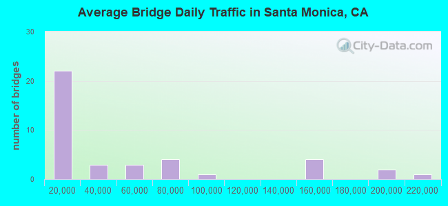
- 1,954,809Total average daily traffic
- 35,818Total average daily truck traffic
- National Bridge Inventory (NBI) Registered Bridges for Santa Monica
- No street view available for this location
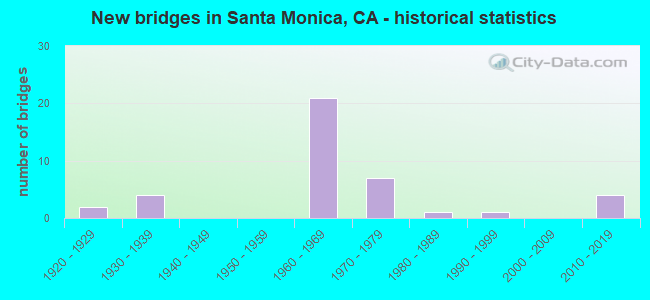
- New bridges - historical statistics
- 21920-1929
- 41930-1939
- 211960-1969
- 71970-1979
- 11980-1989
- 11990-1999
- 42010-2019
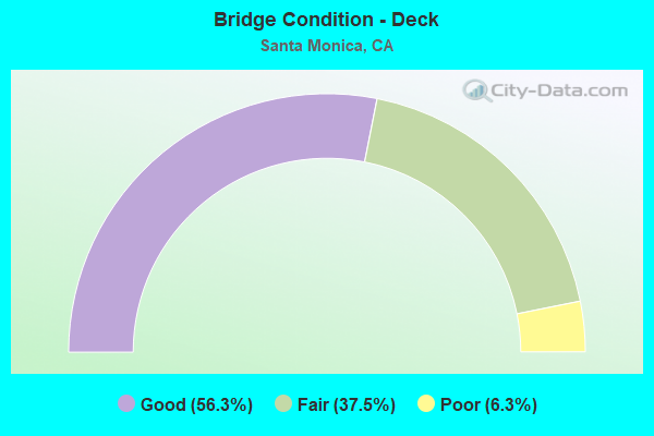
- Bridge Condition - Deck
- 56.3%Good
- 37.5%Fair
- 6.3%Poor
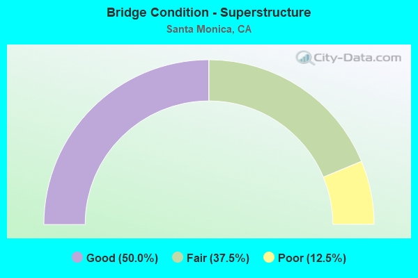
- Bridge Condition - Superstructure
- 50.0%Good
- 37.5%Fair
- 12.5%Poor
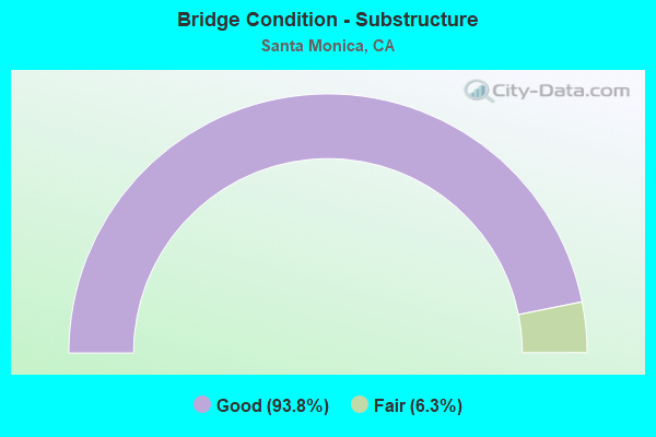
- Bridge Condition - Substructure
- 93.8%Good
- 6.3%Fair
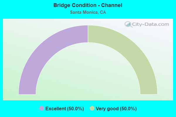
- Bridge Condition - Channel
- 50.0%Excellent
- 50.0%Very good
Find on map >> Show street view
Structure Number: 53 0382, Location: 07-LA-110-24.16-LA (Lat: 34.065775, Lng: -118.242650), Route carried "on" structure: City street , Year Built: 1939, Status: Open, Structure Length: 5.79m (19.00ft), Average Daily Traffic: 2,000 (year 2020), Truck Traffic: 1%, Average Future Daily Traffic: 2,266 (year 2037), Design Load: HS 20, Features Intersected: STATE ROUTE 110, Facility Carried by Structure: COLLEGE STREET
Minimum Vertical Clearance: 30+ m (98+ ft), Kilometerpoint: 0.000, Lanes on structure: 2, Lanes under structure: 6, Owner: State Highway Agency, Approaching Roadway Width: 11.6m (38.1ft), Skew: 3 degrees, Material/Design: Concrete continuous, Design/Construction: Box Beam or Girders - Multiple, Number Of Spans In Main Unit: 3, Length of Maximum Span: 36.3m (119.1ft), Curb or Sidewalk Widths: Left: 1.5m (4.9ft), Right: 1.5m (4.9ft), Curb-To-Curb Width: 7.3m (24.0ft), Out-to-Out Width: 11.3m (37.1ft)
Condition: Deck: Good, Superstructure: Good, Substructure: Good, Operating Rating: 37.9 metric tons, Method Used To Determine Operating Rating: Load and Resistance Factor Rating (LRFR) rating reported by rating factor(RF) method using HL-93 loadings, Inventory Rating: 29.2 metric tons, Method Used To Determine Inventory Rating: Load and Resistance Factor Rating (LRFR) rating reported by rating factor(RF) method using HL-93 loadings, Structural Evaluation: Better than present minimum criteria, Deck Geometry: Meets minimum limits, Underclear: High priority of corrective action, Approach Roadway Alignment: Superior to present desirable criteria, Designated Inspection Frequency: Every 24 months, Inspection Date: November 2020, Deck Structure Type: Concrete Cast-file-Place, Wearing Surface/Protective System: Wearing Surface: Bituminous
Find on map >> Show street view
Structure Number: 53 1592, Location: 07-LA-001-R34.89-SMCA (Lat: 34.012400, Lng: -118.490342), Route carried "on" structure: City street L659, Year Built: 1965, Status: Open, Structure Length: 4.66m (15.29ft), Average Daily Traffic: 34,000 (year 2017), Truck Traffic: 2%, Average Future Daily Traffic: 39,812 (year 2040), Design Load: HS 20, Features Intersected: ROUTE 1, Facility Carried by Structure: FOURTH ST
Minimum Vertical Clearance: 30+ m (98+ ft), Kilometerpoint: 0.000, Lanes on structure: 5, Lanes under structure: 4, Owner: State Highway Agency, Approaching Roadway Width: 16.8m (55.1ft), Skew: 4 degrees, Material/Design: Concrete continuous, Design/Construction: Box Beam or Girders - Multiple, Number Of Spans In Main Unit: 2, Length of Maximum Span: 22.6m (74.1ft), Curb or Sidewalk Widths: Left: 2.7m (8.9ft), Right: 2.7m (8.9ft), Curb-To-Curb Width: 16.8m (55.1ft), Out-to-Out Width: 22.9m (75.1ft)
Condition: Deck: Good, Superstructure: Good, Substructure: Good, Operating Rating: 54.4 metric tons, Method Used To Determine Operating Rating: Load and Resistance Factor Rating (LRFR) rating reported by rating factor(RF) method using HL-93 loadings, Inventory Rating: 39.5 metric tons, Method Used To Determine Inventory Rating: Load and Resistance Factor Rating (LRFR) rating reported by rating factor(RF) method using HL-93 loadings, Structural Evaluation: Better than present minimum criteria, Deck Geometry: High priority of replacement, Underclear: Meets minimum limits, Approach Roadway Alignment: Equal to present desirable criteria, Designated Inspection Frequency: Every 24 months, Inspection Date: November 2021, Deck Structure Type: Concrete Cast-file-Place
Find on map >> Show street view
Structure Number: 53 1594, Location: 07-LA-001-R34.55-SMCA (Lat: 34.014675, Lng: -118.485519), Route carried "on" structure: State highway 1, Year Built: 1965, Status: Open, Structure Length: 7.01m (23.00ft), Average Daily Traffic: 48,000 (year 2017), Truck Traffic: 3%, Average Future Daily Traffic: 50,172 (year 2040), Design Load: HS 20, Features Intersected: INTERSTATE 10, Facility Carried by Structure: LINCOLN BLVD
Minimum Vertical Clearance: 30+ m (98+ ft), Kilometerpoint: 34.550, Lanes on structure: 7, Lanes under structure: 6, Base Highway Network: Yes (, Subroute: 1), Owner: State Highway Agency, Approaching Roadway Width: 25.9m (85.0ft), Material/Design: Concrete continuous, Design/Construction: Box Beam or Girders - Multiple, Number Of Spans In Main Unit: 2, Length of Maximum Span: 34.1m (111.9ft), Curb or Sidewalk Widths: Left: 2.4m (7.9ft), Right: 2.4m (7.9ft), Curb-To-Curb Width: 25.9m (85.0ft), Out-to-Out Width: 31.4m (103.0ft)
Condition: Deck: Good, Superstructure: Good, Substructure: Good, Operating Rating: 44.4 metric tons, Method Used To Determine Operating Rating: Load and Resistance Factor Rating (LRFR) rating reported by rating factor(RF) method using HL-93 loadings, Inventory Rating: 34.3 metric tons, Method Used To Determine Inventory Rating: Load and Resistance Factor Rating (LRFR) rating reported by rating factor(RF) method using HL-93 loadings, Structural Evaluation: Better than present minimum criteria, Deck Geometry: Meets minimum limits, Underclear: Meets minimum limits, Approach Roadway Alignment: Equal to present desirable criteria, Designated Inspection Frequency: Every 24 months, Inspection Date: November 2021, Deck Structure Type: Concrete Cast-file-Place
Find on map >> Show street view
Structure Number: 53 1595, Location: 07-LA-010-R2.38-SMCA (Lat: 34.016706, Lng: -118.482489), Route carried "on" structure: City street , Year Built: 1965, Status: Open, Structure Length: 6.02m (19.75ft), Average Daily Traffic: 13,525 (year 2012), Truck Traffic: 5%, Average Future Daily Traffic: 16,696 (year 2042), Design Load: HS 20, Features Intersected: INTERSTATE 10, Facility Carried by Structure: 11TH STREET
Minimum Vertical Clearance: 30+ m (98+ ft), Kilometerpoint: 0.000, Lanes on structure: 3, Lanes under structure: 10, Owner: State Highway Agency, Approaching Roadway Width: 18.3m (60.0ft), Material/Design: Concrete continuous, Design/Construction: Box Beam or Girders - Multiple, Number Of Spans In Main Unit: 2, Length of Maximum Span: 31.2m (102.4ft), Curb or Sidewalk Widths: Left: 1.8m (5.9ft), Right: 1.8m (5.9ft), Curb-To-Curb Width: 18.3m (60.0ft), Out-to-Out Width: 22.6m (74.1ft)
Condition: Deck: Good, Superstructure: Fair, Substructure: Good, Operating Rating: 37.9 metric tons, Method Used To Determine Operating Rating: Load and Resistance Factor Rating (LRFR) rating reported by rating factor(RF) method using HL-93 loadings, Inventory Rating: 29.2 metric tons, Method Used To Determine Inventory Rating: Load and Resistance Factor Rating (LRFR) rating reported by rating factor(RF) method using HL-93 loadings, Structural Evaluation: Somewhat better than minimum adequacy, Deck Geometry: Superior to present desirable criteria, Underclear: High priority of corrective action, Approach Roadway Alignment: Superior to present desirable criteria, Designated Inspection Frequency: Every 24 months, Inspection Date: Febuary 2022, Deck Structure Type: Concrete Cast-file-Place
Find on map >> Show street view
Structure Number: 53 1596, Location: 07-LA-010-R2.61-SMCA (Lat: 34.018964, Lng: -118.479592), Route carried "on" structure: City street , Year Built: 1965, Status: Open, Structure Length: 7.18m (23.56ft), Average Daily Traffic: 10,275 (year 2012), Truck Traffic: 1%, Average Future Daily Traffic: 12,843 (year 2042), Design Load: HS 20, Features Intersected: INTERSTATE 10, Facility Carried by Structure: 14TH STREET
Minimum Vertical Clearance: 30+ m (98+ ft), Kilometerpoint: 0.000, Lanes on structure: 2, Lanes under structure: 8, Owner: State Highway Agency, Approaching Roadway Width: 18.3m (60.0ft), Material/Design: Concrete continuous, Design/Construction: Box Beam or Girders - Multiple, Number Of Spans In Main Unit: 2, Length of Maximum Span: 35.9m (117.8ft), Curb or Sidewalk Widths: Left: 1.8m (5.9ft), Right: 1.8m (5.9ft), Curb-To-Curb Width: 18.3m (60.0ft), Out-to-Out Width: 22.6m (74.1ft)
Condition: Deck: Good, Superstructure: Fair, Substructure: Good, Operating Rating: 53.1 metric tons, Method Used To Determine Operating Rating: Load and Resistance Factor Rating (LRFR) rating reported by rating factor(RF) method using HL-93 loadings, Inventory Rating: 40.8 metric tons, Method Used To Determine Inventory Rating: Load and Resistance Factor Rating (LRFR) rating reported by rating factor(RF) method using HL-93 loadings, Structural Evaluation: Somewhat better than minimum adequacy, Deck Geometry: Superior to present desirable criteria, Underclear: Meets minimum limits, Approach Roadway Alignment: Superior to present desirable criteria, Designated Inspection Frequency: Every 24 months, Inspection Date: Febuary 2022, Deck Structure Type: Concrete Cast-file-Place
Find on map >> Show street view
Structure Number: 53 1597, Location: 07-LA-010-R2.84-SMCA (Lat: 34.021228, Lng: -118.476742), Route carried "on" structure: City street , Year Built: 1965, Status: Open, Structure Length: 7.90m (25.92ft), Average Daily Traffic: 2,900 (year 2012), Truck Traffic: 1%, Average Future Daily Traffic: 3,588 (year 2042), Design Load: HS 20, Features Intersected: INTERSTATE 10, Facility Carried by Structure: 17TH STREET
Minimum Vertical Clearance: 30+ m (98+ ft), Kilometerpoint: 0.000, Lanes on structure: 2, Lanes under structure: 8, Owner: State Highway Agency, Approaching Roadway Width: 18.3m (60.0ft), Material/Design: Concrete continuous, Design/Construction: Box Beam or Girders - Multiple, Number Of Spans In Main Unit: 4, Length of Maximum Span: 25.6m (84.0ft), Curb or Sidewalk Widths: Left: 1.8m (5.9ft), Right: 1.8m (5.9ft), Curb-To-Curb Width: 18.3m (60.0ft), Out-to-Out Width: 22.6m (74.1ft)
Condition: Deck: Good, Superstructure: Fair, Substructure: Good, Operating Rating: 37.3 metric tons, Method Used To Determine Operating Rating: Load and Resistance Factor Rating (LRFR) rating reported by rating factor(RF) method using HL-93 loadings, Inventory Rating: 28.5 metric tons, Method Used To Determine Inventory Rating: Load and Resistance Factor Rating (LRFR) rating reported by rating factor(RF) method using HL-93 loadings, Structural Evaluation: Somewhat better than minimum adequacy, Deck Geometry: Superior to present desirable criteria, Underclear: High priority of corrective action, Approach Roadway Alignment: Superior to present desirable criteria, Designated Inspection Frequency: Every 24 months, Inspection Date: Febuary 2022, Deck Structure Type: Concrete Cast-file-Place
Find on map >> Show street view
Structure Number: 53 1598, Location: 07-LA-010-R3.07-SMCA (Lat: 34.023106, Lng: -118.473386), Route carried "on" structure: City street , Year Built: 1965, Status: Open, Structure Length: 7.33m (24.05ft), Average Daily Traffic: 15,690 (year 2010), Truck Traffic: 8%, Average Future Daily Traffic: 18,417 (year 2042), Design Load: HS 20, Features Intersected: INTERSTATE 10, Facility Carried by Structure: 20TH STREET
Minimum Vertical Clearance: 30+ m (98+ ft), Kilometerpoint: 0.000, Lanes on structure: 4, Lanes under structure: 6, Owner: State Highway Agency, Approaching Roadway Width: 18.3m (60.0ft), Skew: 2 degrees, Material/Design: Concrete continuous, Design/Construction: Box Beam or Girders - Multiple, Number Of Spans In Main Unit: 4, Length of Maximum Span: 24.4m (80.1ft), Curb or Sidewalk Widths: Left: 2.4m (7.9ft), Right: 2.4m (7.9ft), Curb-To-Curb Width: 18.3m (60.0ft), Out-to-Out Width: 23.8m (78.1ft)
Condition: Deck: Fair, Superstructure: Fair, Substructure: Good, Operating Rating: 53.8 metric tons, Method Used To Determine Operating Rating: Load and Resistance Factor Rating (LRFR) rating reported by rating factor(RF) method using HL-93 loadings, Inventory Rating: 40.5 metric tons, Method Used To Determine Inventory Rating: Load and Resistance Factor Rating (LRFR) rating reported by rating factor(RF) method using HL-93 loadings, Structural Evaluation: Somewhat better than minimum adequacy, Deck Geometry: Somewhat better than minimum adequacy, Underclear: Somewhat better than minimum adequacy, Approach Roadway Alignment: Superior to present desirable criteria, Designated Inspection Frequency: Every 24 months, Inspection Date: Febuary 2022, Deck Structure Type: Concrete Cast-file-Place
Find on map >> Show street view
Structure Number: 53 1599, Location: 07-LA-010-R3.34-SMCA (Lat: 34.024397, Lng: -118.468964), Route carried "on" structure: City street , Year Built: 1963, Status: Open, Structure Length: 5.14m (16.86ft), Average Daily Traffic: 24,870 (year 2010), Truck Traffic: 2%, Average Future Daily Traffic: 31,184 (year 2042), Design Load: HS 20, Features Intersected: INTERSTATE 10, Facility Carried by Structure: CLOVERFIELD BLVD
Minimum Vertical Clearance: 30+ m (98+ ft), Kilometerpoint: 0.000, Lanes on structure: 6, Lanes under structure: 6, Base Highway Network: Yes, Owner: State Highway Agency, Approaching Roadway Width: 20.7m (67.9ft), Skew: 22 degrees, Material/Design: Concrete continuous, Design/Construction: Box Beam or Girders - Multiple, Number Of Spans In Main Unit: 2, Length of Maximum Span: 25.7m (84.3ft), Curb or Sidewalk Widths: Left: 1.8m (5.9ft), Right: 1.8m (5.9ft), Curb-To-Curb Width: 20.7m (67.9ft), Out-to-Out Width: 26.8m (87.9ft)
Condition: Deck: Fair, Superstructure: Good, Substructure: Fair, Operating Rating: 53.5 metric tons, Method Used To Determine Operating Rating: Load and Resistance Factor Rating (LRFR) rating reported by rating factor(RF) method using HL-93 loadings, Inventory Rating: 38.6 metric tons, Method Used To Determine Inventory Rating: Load and Resistance Factor Rating (LRFR) rating reported by rating factor(RF) method using HL-93 loadings, Structural Evaluation: Somewhat better than minimum adequacy, Deck Geometry: High priority of replacement, Underclear: Somewhat better than minimum adequacy, Approach Roadway Alignment: Superior to present desirable criteria, Designated Inspection Frequency: Every 24 months, Inspection Date: Febuary 2022, Deck Structure Type: Concrete Cast-file-Place, Wearing Surface/Protective System: Wearing Surface: Monolithic Concrete
Find on map >> Show street view
Structure Number: 53 16, Location: 07-LA-010-R3.71-SMCA (Lat: 34.026039, Lng: -118.462911), Route carried "on" structure: Interstate 10, Year Built: 1965, Status: Open, Structure Length: 4.18m (13.71ft), Average Daily Traffic: 185,000 (year 2010), Average Future Daily Traffic: 202,347 (year 2042), Design Load: HS 20, Features Intersected: STEWART STREET
Minimum Vertical Clearance: 30+ m (98+ ft), Kilometerpoint: 3.710, Lanes on structure: 8, Lanes under structure: 2, Base Highway Network: Yes (, Subroute: 1), Owner: State Highway Agency, Approaching Roadway Width: 41.4m (135.8ft), Skew: 32 degrees, Material/Design: Concrete continuous, Design/Construction: Tee Beam, Number Of Spans In Main Unit: 3, Length of Maximum Span: 21.0m (68.9ft), Curb-To-Curb Width: 41.4m (135.8ft), Out-to-Out Width: 42.9m (140.7ft)
Condition: Deck: Fair, Superstructure: Good, Substructure: Good, Operating Rating: 28.5 metric tons, Method Used To Determine Operating Rating: Load and Resistance Factor Rating (LRFR) rating reported by rating factor(RF) method using HL-93 loadings, Inventory Rating: 22.0 metric tons, Method Used To Determine Inventory Rating: Load and Resistance Factor Rating (LRFR) rating reported by rating factor(RF) method using HL-93 loadings, Structural Evaluation: Somewhat better than minimum adequacy, Deck Geometry: Superior to present desirable criteria, Underclear: Meets minimum limits, Approach Roadway Alignment: Superior to present desirable criteria, Designated Inspection Frequency: Every 24 months, Inspection Date: Febuary 2022, Deck Structure Type: Concrete Cast-file-Place
Find on map >> Show street view
Structure Number: 53 257, Location: 07-LA-105-R16.14-DNY (Lat: 33.912692, Lng: -118.134017), Route carried "on" structure: City street L066, Year Built: 1989, Status: Open, Structure Length: 9.30m (30.51ft), Average Daily Traffic: 12,400 (year 2006), Truck Traffic: 1%, Average Future Daily Traffic: 14,109 (year 2042), Design Load: HS 20+Mod, Features Intersected: ROUTE 105, LRT, Facility Carried by Structure: CLARK AVENUE
Minimum Vertical Clearance: 30+ m (98+ ft), Kilometerpoint: 0.000, Lanes on structure: 4, Lanes under structure: 10, Owner: State Highway Agency, Approaching Roadway Width: 18.3m (60.0ft), Material/Design: Prestressed concrete continuous, Design/Construction: Box Beam or Girders - Multiple, Number Of Spans In Main Unit: 2, Length of Maximum Span: 46.6m (152.9ft), Curb or Sidewalk Widths: Left: 1.5m (4.9ft), Right: 1.5m (4.9ft), Curb-To-Curb Width: 18.3m (60.0ft), Out-to-Out Width: 21.9m (71.9ft)
Condition: Deck: Good, Superstructure: Poor, Substructure: Good, Operating Rating: 54.1 metric tons, Method Used To Determine Operating Rating: Assigned rating based on Load Factor Design (LFD) reported in metric tons, Inventory Rating: 32.4 metric tons, Method Used To Determine Inventory Rating: Assigned rating based on Load Factor Design (LFD) reported in metric tons, Structural Evaluation: Meets minimum limits, Deck Geometry: Somewhat better than minimum adequacy, Underclear: High priority of corrective action, Approach Roadway Alignment: Superior to present desirable criteria, Length Of Structure Improvement: 9.30m (30.51ft), Designated Inspection Frequency: Every 24 months, Inspection Date: July 2020, Bridge Improvement Cost: $2,043,000, Roadway Improvement Cost: $408,000, Total Project Cost: $3,432,000 ( Estimate for 2021), Deck Structure Type: Concrete Cast-file-Place
Find on map >> Show street view
Structure Number: 53 2603, Location: 07-LA-014-R60.60-PMDL (Lat: 34.593339, Lng: -118.134008), Route carried "on" structure: State highway 14, Year Built: 1970, Status: Open, Structure Length: 1.62m (5.31ft), Average Daily Traffic: 89,000 (year 2017), Truck Traffic: 4%, Average Future Daily Traffic: 192,510 (year 2041), Design Load: HS 20, Features Intersected: AVENUE "P-8" DRAIN
Minimum Vertical Clearance: 30+ m (98+ ft), Kilometerpoint: 60.600, Lanes on structure: 6, Base Highway Network: Yes (, Subroute: 1), Owner: State Highway Agency, Approaching Roadway Width: 42.0m (137.8ft), Skew: 1 degrees, Material/Design: Concrete continuous, Design/Construction: Culvert, Number Of Spans In Main Unit: 6, Length of Maximum Span: 2.4m (7.9ft), Curb-To-Curb Width: 42.0m (137.8ft), Out-to-Out Width: 54.3m (178.1ft)
Condition: Channel: Very good, Culverts: Good, Operating Rating: 54.1 metric tons, Method Used To Determine Operating Rating: Field evaluation and documented engineering judgment, Inventory Rating: 32.4 metric tons, Method Used To Determine Inventory Rating: Field evaluation and documented engineering judgment, Structural Evaluation: Better than present minimum criteria, Deck Geometry: Superior to present desirable criteria, Waterway Adequacy: Equal to present desirable criteria, Approach Roadway Alignment: Equal to present desirable criteria, Designated Inspection Frequency: Every 48 months, Inspection Date: March 2019
Find on map >> Show street view
Structure Number: 53 264, Location: 07-LA-010S-18.59-LA (Lat: 34.056006, Lng: -118.211439), Route carried "on" structure: City street , Year Built: 1925, Status: Open, Structure Length: 7.96m (26.12ft), Average Daily Traffic: 5,000 (year 2012), Truck Traffic: 5%, Average Future Daily Traffic: 6,328 (year 2041), Features Intersected: I 10 BUSWAY & METROLINK, Facility Carried by Structure: STATE STREET
Minimum Vertical Clearance: 30+ m (98+ ft), Kilometerpoint: 0.000, Lanes on structure: 4, Lanes under structure: 3, Owner: State Highway Agency, Approaching Roadway Width: 13.0m (42.7ft), Material/Design: Concrete, Design/Construction: Stringer/Multi-beam, Number Of Spans In Main Unit: 8, Length of Maximum Span: 10.4m (34.1ft), Curb or Sidewalk Widths: Left: 1.6m (5.2ft), Right: 1.6m (5.2ft), Curb-To-Curb Width: 13.0m (42.7ft), Out-to-Out Width: 16.8m (55.1ft)
Condition: Deck: Good, Superstructure: Good, Substructure: Good, Operating Rating: 38.6 metric tons, Method Used To Determine Operating Rating: Load and Resistance Factor Rating (LRFR) rating reported by rating factor(RF) method using HL-93 loadings, Inventory Rating: 29.8 metric tons, Method Used To Determine Inventory Rating: Load and Resistance Factor Rating (LRFR) rating reported by rating factor(RF) method using HL-93 loadings, Structural Evaluation: Better than present minimum criteria, Deck Geometry: High priority of replacement, Underclear: High priority of corrective action, Approach Roadway Alignment: Better than present minimum criteria, Designated Inspection Frequency: Every 24 months, Inspection Date: August 2021, Deck Structure Type: Concrete Cast-file-Place
Find on map >> Show street view
Structure Number: 53 2649S, Location: 07-LA-001-R34.67-SMCA (Lat: 34.014072, Lng: -118.487689), Route carried "on" structure: State highway 1, Year Built: 1979, Status: Open, Structure Length: 13.11m (43.01ft), Average Daily Traffic: 7,000 (year 2017), Truck Traffic: 5%, Average Future Daily Traffic: 11,074 (year 2040), Design Load: HS 20, Features Intersected: WB 10-NB 1 CONNECTOR RMP
Minimum Vertical Clearance: 30+ m (98+ ft), Kilometerpoint: 34.670, Lanes on structure: 1, Lanes under structure: 2, Base Highway Network: Yes (, Subroute: 1), Owner: State Highway Agency, Approaching Roadway Width: 7.3m (24.0ft), Skew: 9 degrees, Material/Design: Prestressed concrete continuous, Design/Construction: Box Beam or Girders - Multiple, Number Of Spans In Main Unit: 4, Length of Maximum Span: 46.0m (150.9ft), Curb-To-Curb Width: 7.3m (24.0ft), Out-to-Out Width: 8.4m (27.6ft)
Condition: Deck: Good, Superstructure: Good, Substructure: Good, Operating Rating: 99.8 metric tons, Method Used To Determine Operating Rating: Load Factor (LF), Inventory Rating: 32.4 metric tons, Method Used To Determine Inventory Rating: Load Factor (LF), Structural Evaluation: Better than present minimum criteria, Deck Geometry: High priority of replacement, Underclear: Meets minimum limits, Approach Roadway Alignment: Equal to present desirable criteria, Designated Inspection Frequency: Every 24 months, Inspection Date: November 2021, Deck Structure Type: Concrete Cast-file-Place
Find on map >> Show street view
Structure Number: 53C0109, Location: 0.1MI N/O I-10 FWY (Lat: 34.012922, Lng: -118.490933), Route carried "on" structure: City street , Year Built: 1965, Status: Open, Structure Length: 1.09m (3.58ft), Average Daily Traffic: 17,040 (year 2018), Truck Traffic: 2%, Average Future Daily Traffic: 20,450 (year 2040), Design Load: HS 20+Mod, Features Intersected: SEARS ACCESS TUNNEL, Facility Carried by Structure: 4TH ST
Minimum Vertical Clearance: 30.47m (99.97ft), Kilometerpoint: 0.000, Lanes on structure: 4, Lanes under structure: 1, Owner: City or Municipal Highway Agency, Approaching Roadway Width: 13.1m (43.0ft), Skew: 20 degrees, Material/Design: Concrete, Design/Construction: Stringer/Multi-beam, Number Of Spans In Main Unit: 1, Length of Maximum Span: 9.4m (30.8ft), Curb or Sidewalk Widths: Left: 2.7m (8.9ft), Right: 2.7m (8.9ft), Curb-To-Curb Width: 13.1m (43.0ft), Out-to-Out Width: 22.9m (75.1ft)
Condition: Deck: Fair, Superstructure: Good, Substructure: Good, Operating Rating: 52.2 metric tons, Method Used To Determine Operating Rating: Load Factor (LF), Inventory Rating: 31.4 metric tons, Method Used To Determine Inventory Rating: Load Factor (LF), Structural Evaluation: Better than present minimum criteria, Deck Geometry: High priority of replacement, Underclear: High priority of corrective action, Approach Roadway Alignment: Equal to present desirable criteria, Designated Inspection Frequency: Every 24 months, Inspection Date: April 2020, Deck Structure Type: Concrete Cast-file-Place
Find on map >> Show street view
Structure Number: 53C052, Location: 0.2MI W/O GAREY AVE (Lat: 34.116139, Lng: -117.753489), Route carried "on" structure: City street , Year Built: 1977, Status: Open, Structure Length: 0.85m (2.79ft), Average Daily Traffic: 204 (year 2012), Truck Traffic: 2%, Average Future Daily Traffic: 204 (year 2041), Design Load: HS 20, Features Intersected: LIVE OAK WASH, Facility Carried by Structure: AMHERST ST
Minimum Vertical Clearance: 30.47m (99.97ft), Kilometerpoint: 0.000, Lanes on structure: 2, Owner: City or Municipal Highway Agency, Approaching Roadway Width: 6.1m (20.0ft), Skew: 3 degrees, Material/Design: Concrete, Design/Construction: Slab, Number Of Spans In Main Unit: 1, Length of Maximum Span: 6.4m (21.0ft), Curb or Sidewalk Widths: Left: 1.6m (5.2ft), Right: 1.6m (5.2ft), Curb-To-Curb Width: 12.1m (39.7ft), Out-to-Out Width: 15.9m (52.2ft)
Condition: Deck: Fair, Superstructure: Fair, Substructure: Good, Channel: Excellent, Operating Rating: 91.7 metric tons, Method Used To Determine Operating Rating: Load Factor (LF), Inventory Rating: 54.8 metric tons, Method Used To Determine Inventory Rating: Load Factor (LF), Structural Evaluation: Somewhat better than minimum adequacy, Deck Geometry: Superior to present desirable criteria, Waterway Adequacy: Superior to present desirable criteria, Approach Roadway Alignment: Better than present minimum criteria, Designated Inspection Frequency: Every 24 months, Inspection Date: October 2021, Deck Structure Type: Concrete Cast-file-Place, Wearing Surface/Protective System: Wearing Surface: Monolithic Concrete
Find on map >> Show street view
Structure Number: 53C0528, Location: 0.5MI S/O PICO BLVD (Lat: 34.003914, Lng: -118.481297), Route carried "on" structure: City street L659, Year Built: 1965, Status: Open, Structure Length: 2.01m (6.59ft), Average Daily Traffic: 5,840 (year 2016), Truck Traffic: 2%, Average Future Daily Traffic: 6,720 (year 2040), Design Load: HS 20, Features Intersected: OCEAN PARK BLVD, Facility Carried by Structure: 4TH ST
Minimum Vertical Clearance: 30.47m (99.97ft), Kilometerpoint: 0.000, Lanes on structure: 4, Lanes under structure: 2, Owner: City or Municipal Highway Agency, Approaching Roadway Width: 14.0m (45.9ft), Material/Design: Concrete, Design/Construction: Box Beam or Girders - Single/Spread, Number Of Spans In Main Unit: 1, Length of Maximum Span: 19.5m (64.0ft), Curb or Sidewalk Widths: Left: 2.9m (9.5ft), Right: 2.9m (9.5ft), Curb-To-Curb Width: 18.1m (59.4ft), Out-to-Out Width: 24.3m (79.7ft)
Condition: Deck: Fair, Superstructure: Fair, Substructure: Good, Operating Rating: 48.3 metric tons, Method Used To Determine Operating Rating: Load Factor (LF), Inventory Rating: 29.2 metric tons, Method Used To Determine Inventory Rating: Load Factor (LF), Structural Evaluation: Somewhat better than minimum adequacy, Deck Geometry: Somewhat better than minimum adequacy, Underclear: Equal to present minimum criteria, Approach Roadway Alignment: Equal to present desirable criteria, Designated Inspection Frequency: Every 24 months, Inspection Date: March 2020, Deck Structure Type: Concrete Cast-file-Place
Find on map >> Show street view
Structure Number: 53C19, Location: 0.6MI W/O LINCOLN BLVD (Lat: 34.010175, Lng: -118.496381), Route carried "on" structure: City street , Year Built: 1939, Status: Posted for load, Structure Length: 14.85m (48.72ft), Average Daily Traffic: 727 (year 2014), Truck Traffic: 1%, Average Future Daily Traffic: 800 (year 2041), Design Load: H 15, Features Intersected: APPIAN WAY / PROMENADE, Facility Carried by Structure: COLORADO AVE
Minimum Vertical Clearance: 30.47m (99.97ft), Kilometerpoint: 0.000, Lanes on structure: 2, Lanes under structure: 6, Owner: City or Municipal Highway Agency, Approaching Roadway Width: 7.3m (24.0ft), Material/Design: Concrete, Design/Construction: Slab, Number Of Spans In Main Unit: 17, Length of Maximum Span: 11.0m (36.1ft), Curb-To-Curb Width: 6.2m (20.3ft), Out-to-Out Width: 10.5m (34.4ft)
Condition: Deck: Poor, Superstructure: Poor, Substructure: Good, Operating Rating: 24.6 metric tons, Method Used To Determine Operating Rating: Load Factor (LF), Inventory Rating: 14.9 metric tons, Method Used To Determine Inventory Rating: Load Factor (LF), Structural Evaluation: Meets minimum limits, Deck Geometry: High priority of corrective action, Underclear: High priority of replacement, Approach Roadway Alignment: Better than present minimum criteria, Bridge Posting: Required (Relationship of Operating Rating to Maximum Legal Load: 30.0 - 39.9% below), Length Of Structure Improvement: 14.85m (48.72ft), Designated Inspection Frequency: Every 12 months, Inspection Date: March 2021, Bridge Improvement Cost: $3,571,000, Deck Structure Type: Concrete Cast-file-Place
Find on map >> Show street view
Structure Number: 53 0316, Location: 07-LA-001-35.07-SMCA (Lat: 34.012111, Lng: -118.492822), Route carried "under" structure: State highway 1, Year Built: 1926, Structure Length: 0. m, Average Daily Traffic: 58,000 (year 2017), Truck Traffic: 3%, Features Intersected: ROUTE 1, Facility Carried by Structure: MAIN STREET
Minimum Vertical Clearance: 6.52m (21.39ft), Kilometerpoint: 35.070, Lanes on structure: 2, Lanes under structure: 4, Material/Design: Concrete, Design/Construction: Arch - Deck, Length of Maximum Span: 30.8m (101.0ft)
Find on map >> Show street view
Structure Number: 53 0388, Location: 07-LA-001-35.59-SMCA (Lat: 34.014878, Lng: -118.500289), Route carried "under" structure: State highway 1, Year Built: 1935, Structure Length: 0. m, Average Daily Traffic: 72,000 (year 2021), Truck Traffic: 2%, Features Intersected: STATE ROUTE 1, Facility Carried by Structure: PEDESTRIAN WALKWAY
Minimum Vertical Clearance: 4.42m (14.50ft), Kilometerpoint: 35.590, Lanes under structure: 6, Material/Design: Steel, Design/Construction: Arch - Deck, Length of Maximum Span: 29.0m (95.1ft)
Find on map >> Show street view
Structure Number: 53 1592, Location: 07-LA-001-R34.89-SMCA (Lat: 34.012400, Lng: -118.490342), Route carried "under" structure: State highway 1, Year Built: 1965, Structure Length: 0. m, Average Daily Traffic: 58,000 (year 2017), Truck Traffic: 2%, Features Intersected: ROUTE 1, Facility Carried by Structure: FOURTH ST
Minimum Vertical Clearance: 4.74m (15.55ft), Kilometerpoint: 34.890, Lanes on structure: 5, Lanes under structure: 4, Material/Design: Concrete continuous, Design/Construction: Box Beam or Girders - Multiple, Length of Maximum Span: 22.6m (74.1ft)
Find on map >> Show street view
Structure Number: 53 1594, Location: 07-LA-001-R34.55-SMCA (Lat: 34.014675, Lng: -118.485519), Route carried "under" structure: Interstate 10, Year Built: 1965, Structure Length: 0. m, Average Daily Traffic: 215,000 (year 2017), Truck Traffic: 2%, Features Intersected: INTERSTATE 10, Facility Carried by Structure: LINCOLN BLVD
Minimum Vertical Clearance: 4.70m (15.42ft), Kilometerpoint: 2.160, Lanes on structure: 7, Lanes under structure: 6, Material/Design: Concrete continuous, Design/Construction: Box Beam or Girders - Multiple, Length of Maximum Span: 34.1m (111.9ft)
Find on map >> Show street view
Structure Number: 53 1595, Location: 07-LA-010-R2.38-SMCA (Lat: 34.016706, Lng: -118.482489), Route carried "under" structure: Interstate 10, Year Built: 1965, Structure Length: 0. m, Average Daily Traffic: 141,500 (year 2012), Truck Traffic: 2%, Features Intersected: INTERSTATE 10, Facility Carried by Structure: 11TH STREET
Minimum Vertical Clearance: 4.88m (16.01ft), Kilometerpoint: 2.380, Lanes on structure: 3, Lanes under structure: 10, Material/Design: Concrete continuous, Design/Construction: Box Beam or Girders - Multiple, Length of Maximum Span: 31.2m (102.4ft)
Find on map >> Show street view
Structure Number: 53 1596, Location: 07-LA-010-R2.61-SMCA (Lat: 34.018964, Lng: -118.479592), Route carried "under" structure: Interstate 10, Year Built: 1965, Structure Length: 0. m, Average Daily Traffic: 141,000 (year 2012), Truck Traffic: 2%, Features Intersected: INTERSTATE 10, Facility Carried by Structure: 14TH STREET
Minimum Vertical Clearance: 4.78m (15.68ft), Kilometerpoint: 2.610, Lanes on structure: 2, Lanes under structure: 8, Material/Design: Concrete continuous, Design/Construction: Box Beam or Girders - Multiple, Length of Maximum Span: 35.9m (117.8ft)
Find on map >> Show street view
Structure Number: 53 1597, Location: 07-LA-010-R2.84-SMCA (Lat: 34.021228, Lng: -118.476742), Route carried "under" structure: Interstate 10, Year Built: 1965, Structure Length: 0. m, Average Daily Traffic: 141,000 (year 2012), Truck Traffic: 2%, Features Intersected: INTERSTATE 10, Facility Carried by Structure: 17TH STREET
Minimum Vertical Clearance: 4.95m (16.24ft), Kilometerpoint: 2.840, Lanes on structure: 2, Lanes under structure: 8, Material/Design: Concrete continuous, Design/Construction: Box Beam or Girders - Multiple, Length of Maximum Span: 25.6m (84.0ft)
Find on map >> Show street view
Structure Number: 53 1598, Location: 07-LA-010-R3.07-SMCA (Lat: 34.023106, Lng: -118.473386), Route carried "under" structure: Interstate 10, Year Built: 1965, Structure Length: 0. m, Average Daily Traffic: 141,500 (year 2010), Truck Traffic: 2%, Features Intersected: INTERSTATE 10, Facility Carried by Structure: 20TH STREET
Minimum Vertical Clearance: 4.83m (15.85ft), Kilometerpoint: 3.070, Lanes on structure: 4, Lanes under structure: 6, Material/Design: Concrete continuous, Design/Construction: Box Beam or Girders - Multiple, Length of Maximum Span: 24.4m (80.1ft)
Find on map >> Show street view
Structure Number: 53 1599, Location: 07-LA-010-R3.34-SMCA (Lat: 34.024397, Lng: -118.468964), Route carried "under" structure: Interstate 10, Year Built: 1963, Structure Length: 0. m, Average Daily Traffic: 185,000 (year 2010), Features Intersected: INTERSTATE 10, Facility Carried by Structure: CLOVERFIELD BLVD
Minimum Vertical Clearance: 4.90m (16.08ft), Kilometerpoint: 3.340, Lanes on structure: 6, Lanes under structure: 6, Material/Design: Concrete continuous, Design/Construction: Box Beam or Girders - Multiple, Length of Maximum Span: 25.7m (84.3ft)
Find on map >> Show street view
Structure Number: 53 16, Location: 07-LA-010-R3.71-SMCA (Lat: 34.026039, Lng: -118.462911), Route carried "under" structure: City street , Year Built: 1965, Structure Length: 0. m, Average Daily Traffic: 6,700 (year 2010), Truck Traffic: 1%, Features Intersected: STEWART STREET, Facility Carried by Structure: INTERSTATE 10
Minimum Vertical Clearance: 4.65m (15.26ft), Kilometerpoint: 0.000, Lanes on structure: 8, Lanes under structure: 2, Material/Design: Concrete continuous, Design/Construction: Tee Beam, Length of Maximum Span: 21.0m (68.9ft)
Find on map >> Show street view
Structure Number: 53 1603, Location: 07-LA-010-R4.24-SMCA (Lat: 34.027597, Lng: -118.454450), Route carried "under" structure: City street , Year Built: 1965, Structure Length: 0. m, Average Daily Traffic: 13,180 (year 2010), Truck Traffic: 2%, Features Intersected: PICO BLVD, CENTINELA AVE, Facility Carried by Structure: INTERSTATE 10
Minimum Vertical Clearance: 5.05m (16.57ft), Kilometerpoint: 0.000, Lanes on structure: 8, Lanes under structure: 4, Material/Design: Concrete continuous, Design/Construction: Box Beam or Girders - Multiple, Length of Maximum Span: 32.9m (107.9ft)
Find on map >> Show street view
Structure Number: 53 1603, Location: 07-LA-010-R4.24-SMCA (Lat: 34.027597, Lng: -118.454450), Route carried "under" structure: City street , Year Built: 1965, Structure Length: 0. m, Average Daily Traffic: 23,100 (year 2010), Truck Traffic: 2%, Features Intersected: PICO BLVD, CENTINELA AVE, Facility Carried by Structure: INTERSTATE 10
Minimum Vertical Clearance: 4.67m (15.32ft), Kilometerpoint: 0.000, Lanes on structure: 8, Lanes under structure: 4, Material/Design: Concrete continuous, Design/Construction: Box Beam or Girders - Multiple, Length of Maximum Span: 32.9m (107.9ft)
Find on map >> Show street view
Structure Number: 53 2578, Location: 07-LA-001-35.39-SMCA (Lat: 34.012636, Lng: -118.498008), Route carried "under" structure: City street 1, Year Built: 1979, Structure Length: 0. m, Average Daily Traffic: 77,760 (year 2012), Truck Traffic: 2%, Features Intersected: PACIFIC COAST HIGHWAY, Facility Carried by Structure: BROADWAY POC
Minimum Vertical Clearance: 5.56m (18.24ft), Kilometerpoint: 35.390, Lanes under structure: 6, Material/Design: Prestressed concrete, Design/Construction: Box Beam or Girders - Multiple, Length of Maximum Span: 41.5m (136.2ft)
Find on map >> Show street view
Structure Number: 53 2579, Location: 07-LA-001-36.04-SMCA (Lat: 34.019467, Lng: -118.505944), Route carried "under" structure: State highway 1, Year Built: 1979, Structure Length: 0. m, Average Daily Traffic: 72,000 (year 2021), Truck Traffic: 2%, Features Intersected: STATE ROUTE 1, Facility Carried by Structure: PEDESTRIAN WALKWAY
Minimum Vertical Clearance: 5.70m (18.70ft), Kilometerpoint: 36.040, Lanes under structure: 6, Material/Design: Prestressed concrete continuous, Design/Construction: Box Beam or Girders - Multiple, Length of Maximum Span: 42.7m (140.1ft)
Find on map >> Show street view
Structure Number: 53 2602, Location: 07-LA-001-36.25-SMCA (Lat: 34.021169, Lng: -118.508119), Route carried "under" structure: State highway 1, Year Built: 1979, Structure Length: 0. m, Average Daily Traffic: 76,000 (year 2017), Truck Traffic: 2%, Features Intersected: STATE ROUTE 1, Facility Carried by Structure: PEDESTRIAN WALKWAY
Minimum Vertical Clearance: 5.82m (19.09ft), Kilometerpoint: 36.250, Lanes under structure: 6, Material/Design: Prestressed concrete continuous, Design/Construction: Box Beam or Girders - Multiple, Length of Maximum Span: 36.0m (118.1ft)
Find on map >> Show street view
Structure Number: 53 2649S, Location: 07-LA-001-R34.67-SMCA (Lat: 34.014072, Lng: -118.487689), Route carried "under" structure: Ramp State highway 1, Year Built: 1979, Structure Length: 0. m, Average Daily Traffic: 2,300 (year 2017), Truck Traffic: 2%, Features Intersected: WB 10-NB 1 CONNECTOR RMP
Minimum Vertical Clearance: 4.72m (15.49ft), Kilometerpoint: 34.670, Lanes on structure: 1, Lanes under structure: 2, Material/Design: Prestressed concrete continuous, Design/Construction: Box Beam or Girders - Multiple, Length of Maximum Span: 46.0m (150.9ft)
Find on map >> Show street view
Structure Number: 53 2740K, Location: 07-LA-001-R34.83-SMCA (Lat: 34.013283, Lng: -118.488131), Route carried "under" structure: State highway 1, Year Built: 1992, Structure Length: 0. m, Average Daily Traffic: 2,920 (year 2017), Truck Traffic: 2%, Features Intersected: S1-LINCOLN BL OFF-RAMP
Minimum Vertical Clearance: 5.26m (17.26ft), Kilometerpoint: 34.830, Lanes on structure: 2, Lanes under structure: 4, Material/Design: Prestressed concrete continuous, Design/Construction: Box Beam or Girders - Multiple, Length of Maximum Span: 32.9m (107.9ft)
Find on map >> Show street view
Structure Number: 53C0528, Location: 0.5MI S/O PICO BLVD (Lat: 34.003914, Lng: -118.481297), Route carried "under" structure: ServiceCity street , Year Built: 1965, Structure Length: 0. m, Average Daily Traffic: 3,200 (year 2012), Features Intersected: OCEAN PARK BLVD, Facility Carried by Structure: 4TH ST
Minimum Vertical Clearance: 4.59m (15.06ft), Kilometerpoint: 0.000, Lanes on structure: 4, Lanes under structure: 2, Material/Design: Concrete, Design/Construction: Box Beam or Girders - Single/Spread, Length of Maximum Span: 19.5m (64.0ft)
Find on map >> Show street view
Structure Number: 53C19, Location: 0.6MI W/O LINCOLN BLVD (Lat: 34.010175, Lng: -118.496381), Route carried "under" structure: City street , Year Built: 1939, Structure Length: 0. m, Average Daily Traffic: 500 (year 2012), Truck Traffic: 1%, Features Intersected: APPIAN WAY / PROMENADE, Facility Carried by Structure: COLORADO AVE
Minimum Vertical Clearance: 4.60m (15.09ft), Kilometerpoint: 0.000, Lanes on structure: 2, Lanes under structure: 2, Material/Design: Concrete, Design/Construction: Slab, Length of Maximum Span: 11.0m (36.1ft)
Find on map >> Show street view
Structure Number: 53C2334, Location: 0.1 MI E PACIFIC COAST HY (Lat: 34.019592, Lng: -118.505358), Route carried "under" structure: City street Q110, Year Built: 2016, Structure Length: 0. m, Average Daily Traffic: 10,118 (year 2012), Truck Traffic: 2%, Features Intersected: CALIFORNIA INCLINE, Facility Carried by Structure: IDAHO AVENUE POC
Minimum Vertical Clearance: 5.90m (19.36ft), Kilometerpoint: 0.000, Lanes under structure: 2, Material/Design: Concrete continuous, Design/Construction: Slab, Length of Maximum Span: 16.1m (52.8ft)
Find on map >> Show street view
Structure Number: 53C2344, Location: 80FT S/O OLYMPIC BLVD (Lat: 34.026972, Lng: -118.472111), Route carried "under" structure: City street , Year Built: 2013, Structure Length: 0. m, Average Daily Traffic: 13,520 (year 2016), Truck Traffic: 2%, Features Intersected: CLOVERFIELD BLVD, Facility Carried by Structure: EXPOSITION LRT
Minimum Vertical Clearance: 5.79m (19.00ft), Kilometerpoint: 0.000, Lanes under structure: 4, Material/Design: Prestressed concrete continuous, Design/Construction: Box Beam or Girders - Single/Spread, Length of Maximum Span: 44.1m (144.7ft)
Find on map >> Show street view
Structure Number: 53C2345, Location: 581 FT W/O CLOVERFIELD BL (Lat: 34.026333, Lng: -118.473778), Route carried "under" structure: City street , Year Built: 2013, Structure Length: 0. m, Average Daily Traffic: 13,520 (year 2016), Truck Traffic: 2%, Features Intersected: OLYMPIC BLVD, Facility Carried by Structure: EXPOSITION LRT
Minimum Vertical Clearance: 4.88m (16.01ft), Kilometerpoint: 0.000, Lanes under structure: 4, Material/Design: Prestressed concrete continuous, Design/Construction: Box Beam or Girders - Single/Spread, Length of Maximum Span: 48.9m (160.4ft)
Find on map >> Show street view
Structure Number: 53C2346, Location: 330 FT S/O W. OLYMIPIC BL (Lat: 34.030778, Lng: -118.457389), Route carried "under" structure: City street , Year Built: 2014, Structure Length: 0. m, Average Daily Traffic: 13,520 (year 2016), Truck Traffic: 2%, Features Intersected: S. CENTINELA AVE, Facility Carried by Structure: EXPOSITION LRT
Minimum Vertical Clearance: 4.88m (16.01ft), Kilometerpoint: 0.000, Lanes under structure: 4, Material/Design: Prestressed concrete, Design/Construction: Stringer/Multi-beam, Length of Maximum Span: 26.0m (85.3ft)