Bridge Statistics for Sandy, Utah (UT)
Condition, Traffic, Stress, Structural Evaluation, Project Costs
- National Bridge Inventory (NBI) Statistics
- 34Number of bridges
- 154ft / 47.3mTotal length
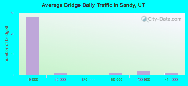
- 1,163,567Total average daily traffic
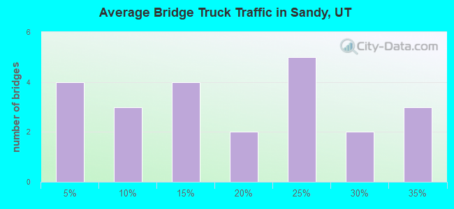
- 216,081Total average daily truck traffic
- National Bridge Inventory (NBI) Registered Bridges for Sandy
- No street view available for this location
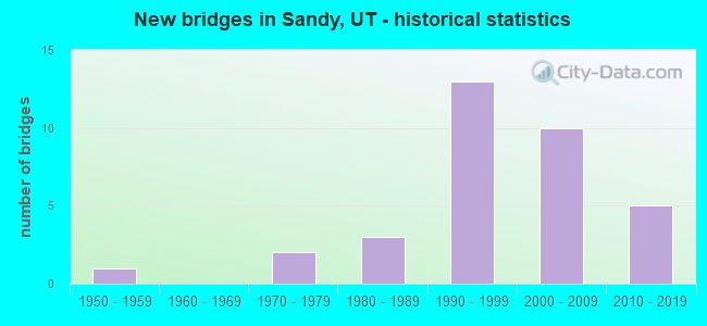
- New bridges - historical statistics
- 11950-1959
- 21970-1979
- 31980-1989
- 131990-1999
- 102000-2009
- 52010-2019
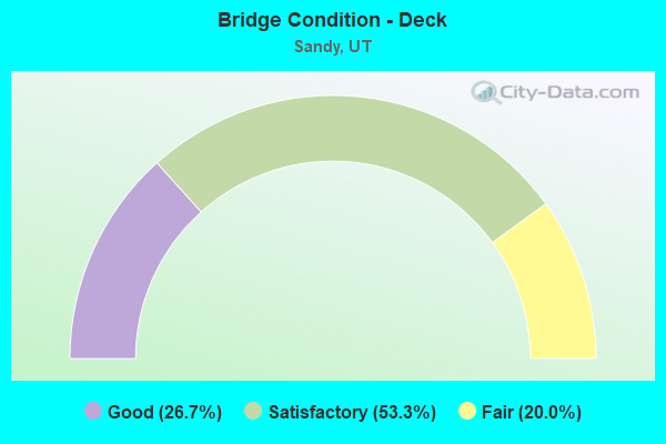
- Bridge Condition - Deck
- 26.7%Good
- 53.3%Satisfactory
- 20.0%Fair
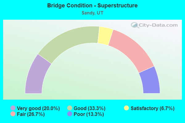
- Bridge Condition - Superstructure
- 20.0%Very good
- 33.3%Good
- 6.7%Satisfactory
- 26.7%Fair
- 13.3%Poor
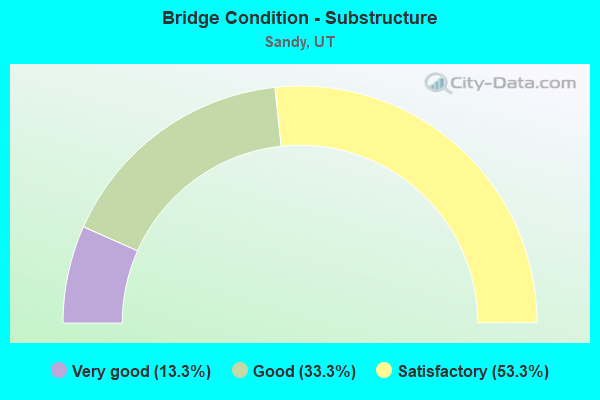
- Bridge Condition - Substructure
- 13.3%Very good
- 33.3%Good
- 53.3%Satisfactory
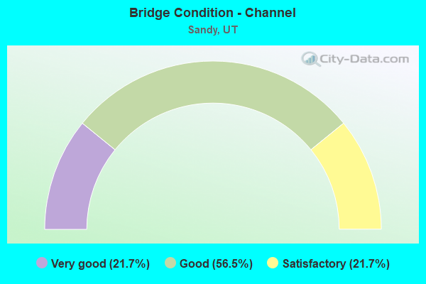
- Bridge Condition - Channel
- 21.7%Very good
- 56.5%Good
- 21.7%Satisfactory
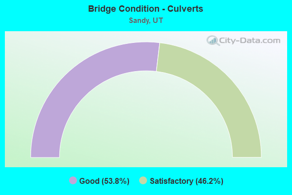
- Bridge Condition - Culverts
- 53.8%Good
- 46.2%Satisfactory
Find on map >> Show street view
Structure Number: 35036F, Location: 480 E. 8000 S., SANDY (Lat: 40.605856, Lng: -111.877564), Route carried "on" structure: City street 2090, Year Built: 1985, Status: Open, Structure Length: 0.76m (2.49ft), Average Daily Traffic: 500 (year 2020), Average Future Daily Traffic: 625 (year 2040), Design Load: HS 20+Mod, Features Intersected: EAST JORDAN CANAL, Facility Carried by Structure: 8000 SOUTH STREET
Minimum Vertical Clearance: 30+ m (98+ ft), Kilometerpoint: 2.768, Lanes on structure: 2, Owner: City or Municipal Highway Agency, Approaching Roadway Width: 11.6m (38.1ft), Skew: 3 degrees, Material/Design: Prestressed concrete, Design/Construction: Tee Beam, Number Of Spans In Main Unit: 1, Length of Maximum Span: 6.7m (22.0ft), Curb or Sidewalk Widths: Left: 1.2m (3.9ft), Right: 1.2m (3.9ft), Curb-To-Curb Width: 11.6m (38.1ft), Out-to-Out Width: 24.6m (80.7ft)
Condition: Deck: Satisfactory, Superstructure: Fair, Substructure: Satisfactory, Channel: Good, Operating Rating: 32.4 metric tons, Method Used To Determine Operating Rating: Load and Resistance Factor Rating (LRFR) rating reported by rating factor(RF) method using HL-93 loadings, Inventory Rating: 19.8 metric tons, Method Used To Determine Inventory Rating: Load Factor (LF) rating reported by rating factor (RF) method using MS18 loading, Structural Evaluation: Somewhat better than minimum adequacy, Deck Geometry: Better than present minimum criteria, Waterway Adequacy: Better than present minimum criteria, Approach Roadway Alignment: Equal to present desirable criteria, Designated Inspection Frequency: Every 24 months, Inspection Date: Febuary 2020, Deck Structure Type: Concrete Precast Panels, Wearing Surface/Protective System: Wearing Surface: Monolithic Concrete
Find on map >> Show street view
Structure Number: 35038D, Location: 240 E. 8680 S., SANDY (Lat: 40.593808, Lng: -111.883600), Route carried "on" structure: City street 2086, Year Built: 2003, Status: Open, Structure Length: 0.96m (3.15ft), Average Daily Traffic: 1,289 (year 2020), Average Future Daily Traffic: 1,611 (year 2040), Design Load: HS 20+Mod, Features Intersected: EAST JORDAN CANAL, Facility Carried by Structure: 8680 SOUTH STREET
Minimum Vertical Clearance: 30+ m (98+ ft), Kilometerpoint: 0.612, Lanes on structure: 2, Owner: City or Municipal Highway Agency, Approaching Roadway Width: 12.2m (40.0ft), Skew: 3 degrees, Material/Design: Concrete, Design/Construction: Frame, Number Of Spans In Main Unit: 1, Length of Maximum Span: 9.0m (29.5ft), Curb or Sidewalk Widths: Left: 3.5m (11.5ft), Right: 3.5m (11.5ft), Curb-To-Curb Width: 12.2m (40.0ft), Out-to-Out Width: 21.3m (69.9ft)
Condition: Deck: Good, Superstructure: Good, Substructure: Good, Channel: Good, Operating Rating: 32.4 metric tons, Method Used To Determine Operating Rating: Load and Resistance Factor Rating (LRFR) rating reported by rating factor(RF) method using HL-93 loadings, Inventory Rating: 19.8 metric tons, Method Used To Determine Inventory Rating: Load Factor (LF) rating reported by rating factor (RF) method using MS18 loading, Structural Evaluation: Somewhat better than minimum adequacy, Deck Geometry: Better than present minimum criteria, Waterway Adequacy: Better than present minimum criteria, Approach Roadway Alignment: Better than present minimum criteria, Designated Inspection Frequency: Every 24 months, Inspection Date: Febuary 2022, Deck Structure Type: Concrete Precast Panels, Wearing Surface/Protective System: Wearing Surface: Bituminous
Find on map >> Show street view
Structure Number: 35039E, Location: 250 E. 8720 S., SANDY (Lat: 40.593086, Lng: -111.884725), Route carried "on" structure: City street , Year Built: 1996, Status: Open, Structure Length: 0.72m (2.36ft), Average Daily Traffic: 3,233 (year 2020), Truck Traffic: 1%, Average Future Daily Traffic: 3,928 (year 2040), Design Load: HS 20+Mod, Features Intersected: EAST JORDAN CANAL, Facility Carried by Structure: 8720 SOUTH STREET
Minimum Vertical Clearance: 30+ m (98+ ft), Kilometerpoint: 0.015, Lanes on structure: 2, Owner: City or Municipal Highway Agency, Approaching Roadway Width: 12.2m (40.0ft), Skew: 5 degrees, Material/Design: Concrete, Design/Construction: Culvert, Number Of Spans In Main Unit: 1, Length of Maximum Span: 6.4m (21.0ft), Curb or Sidewalk Widths: Left: 1.5m (4.9ft), Right: 1.5m (4.9ft)
Condition: Channel: Good, Culverts: Good, Operating Rating: 38.2 metric tons, Method Used To Determine Operating Rating: Load Factor (LF) rating reported by rating factor (RF) method using MS18 loading, Inventory Rating: 24.3 metric tons, Method Used To Determine Inventory Rating: Load Factor (LF) rating reported by rating factor (RF) method using MS18 loading, Structural Evaluation: Equal to present minimum criteria, Waterway Adequacy: Better than present minimum criteria, Approach Roadway Alignment: Equal to present desirable criteria, Designated Inspection Frequency: Every 24 months, Underwater Inspection Frequency: Every 60 months, Inspection Date: Febuary 2020
Find on map >> Show street view
Structure Number: 35040E, Location: 200 E. 8800 S., SANDY (Lat: 40.591667, Lng: -111.884906), Route carried "on" structure: City street , Year Built: 2006, Status: Open, Structure Length: 0.73m (2.40ft), Average Daily Traffic: 1,626 (year 2020), Truck Traffic: 5%, Average Future Daily Traffic: 1,976 (year 2040), Design Load: HL 93, Features Intersected: EAST JORDAN CANAL, Facility Carried by Structure: 8800 SOUTH STREET
Minimum Vertical Clearance: 30+ m (98+ ft), Kilometerpoint: 0.011, Lanes on structure: 2, Owner: City or Municipal Highway Agency, Approaching Roadway Width: 10.5m (34.4ft), Material/Design: Concrete, Design/Construction: Culvert, Number Of Spans In Main Unit: 1, Length of Maximum Span: 6.7m (22.0ft), Curb or Sidewalk Widths: Left: 1.8m (5.9ft), Right: 1.8m (5.9ft), Curb-To-Curb Width: 10.5m (34.4ft), Out-to-Out Width: 15.1m (49.5ft)
Condition: Channel: Good, Culverts: Good, Operating Rating: 35.3 metric tons, Method Used To Determine Operating Rating: Load and Resistance Factor Rating (LRFR) rating reported by rating factor(RF) method using HL-93 loadings, Inventory Rating: 28.5 metric tons, Method Used To Determine Inventory Rating: Load and Resistance Factor Rating (LRFR) rating reported by rating factor(RF) method using HL-93 loadings, Structural Evaluation: Better than present minimum criteria, Deck Geometry: Equal to present minimum criteria, Waterway Adequacy: Equal to present desirable criteria, Approach Roadway Alignment: Equal to present desirable criteria, Designated Inspection Frequency: Every 24 months, Inspection Date: December 2021
Find on map >> Show street view
Structure Number: 35045E, Location: 150 E. 11000 S., SANDY (Lat: 40.551581, Lng: -111.886192), Route carried "on" structure: City street 2061, Year Built: 1996, Status: Open, Structure Length: 0.85m (2.79ft), Average Daily Traffic: 9,251 (year 2020), Average Future Daily Traffic: 11,564 (year 2040), Design Load: HS 20+Mod, Features Intersected: EAST JORDAN CANAL, Facility Carried by Structure: 11000 SOUTH STREET
Minimum Vertical Clearance: 30+ m (98+ ft), Kilometerpoint: 0.663, Lanes on structure: 2, Owner: City or Municipal Highway Agency, Approaching Roadway Width: 17.1m (56.1ft), Skew: 3 degrees, Material/Design: Concrete, Design/Construction: Culvert, Number Of Spans In Main Unit: 1, Length of Maximum Span: 7.7m (25.3ft), Curb or Sidewalk Widths: Left: 1.5m (4.9ft), Right: 1.5m (4.9ft), Curb-To-Curb Width: 17.1m (56.1ft), Out-to-Out Width: 24.1m (79.1ft)
Condition: Channel: Good, Culverts: Good, Operating Rating: 37.3 metric tons, Method Used To Determine Operating Rating: Load and Resistance Factor Rating (LRFR) rating reported by rating factor(RF) method using HL-93 loadings, Inventory Rating: 31.4 metric tons, Method Used To Determine Inventory Rating: Load and Resistance Factor Rating (LRFR) rating reported by rating factor(RF) method using HL-93 loadings, Structural Evaluation: Better than present minimum criteria, Deck Geometry: Superior to present desirable criteria, Waterway Adequacy: Equal to present minimum criteria, Approach Roadway Alignment: Equal to present desirable criteria, Designated Inspection Frequency: Every 24 months, Inspection Date: Febuary 2020
Find on map >> Show street view
Structure Number: 35051F, Location: 50 W. 9400 S., SANDY (Lat: 40.580611, Lng: -111.892614), Route carried "on" structure: City street 2098, Year Built: 1980, Status: Open, Structure Length: 0.73m (2.40ft), Average Daily Traffic: 2,429 (year 2020), Average Future Daily Traffic: 3,036 (year 2040), Design Load: HL 93, Features Intersected: EAST JORDAN CANAL, Facility Carried by Structure: 9400 SOUTH STREET
Minimum Vertical Clearance: 30+ m (98+ ft), Kilometerpoint: 0.566, Lanes on structure: 5, Owner: City or Municipal Highway Agency, Approaching Roadway Width: 18.9m (62.0ft), Skew: 12 degrees, Material/Design: Prestressed concrete, Design/Construction: Tee Beam, Number Of Spans In Main Unit: 1, Length of Maximum Span: 6.6m (21.7ft), Curb or Sidewalk Widths: Left: 2.4m (7.9ft), Right: 2.4m (7.9ft), Curb-To-Curb Width: 18.9m (62.0ft), Out-to-Out Width: 24.4m (80.1ft)
Condition: Deck: Satisfactory, Superstructure: Fair, Substructure: Satisfactory, Channel: Good, Operating Rating: 32.4 metric tons, Method Used To Determine Operating Rating: Load and Resistance Factor Rating (LRFR) rating reported by rating factor(RF) method using HL-93 loadings, Inventory Rating: 19.4 metric tons, Method Used To Determine Inventory Rating: Load Factor (LF) rating reported by rating factor (RF) method using MS18 loading, Structural Evaluation: Somewhat better than minimum adequacy, Deck Geometry: Meets minimum limits, Waterway Adequacy: Better than present minimum criteria, Approach Roadway Alignment: Equal to present desirable criteria, Designated Inspection Frequency: Every 24 months, Inspection Date: Febuary 2020, Deck Structure Type: Concrete Precast Panels, Wearing Surface/Protective System: Wearing Surface: Bituminous
Find on map >> Show street view
Structure Number: 35052E, Location: 50 W. 8755 S., SANDY (Lat: 40.592222, Lng: -111.891311), Route carried "on" structure: City street , Year Built: 1989, Status: Open, Structure Length: 0.70m (2.30ft), Average Daily Traffic: 504 (year 2020), Truck Traffic: 1%, Average Future Daily Traffic: 612 (year 2040), Design Load: HS 20+Mod, Features Intersected: JORDAN AND SALT LAKE C, Facility Carried by Structure: COTTAGE AVENUE
Minimum Vertical Clearance: 30+ m (98+ ft), Kilometerpoint: 0.399, Lanes on structure: 2, Owner: City or Municipal Highway Agency, Approaching Roadway Width: 8.2m (26.9ft), Material/Design: Concrete, Design/Construction: Culvert, Number Of Spans In Main Unit: 2, Length of Maximum Span: 3.0m (9.8ft), Curb or Sidewalk Widths: Left: 1.8m (5.9ft), Right: 1.8m (5.9ft)
Condition: Channel: Satisfactory, Culverts: Good, Operating Rating: 83.9 metric tons, Method Used To Determine Operating Rating: Load and Resistance Factor Rating (LRFR) rating reported by rating factor(RF) method using HL-93 loadings, Inventory Rating: 57.0 metric tons, Method Used To Determine Inventory Rating: Load and Resistance Factor Rating (LRFR) rating reported by rating factor(RF) method using HL-93 loadings, Structural Evaluation: Better than present minimum criteria, Waterway Adequacy: Equal to present minimum criteria, Approach Roadway Alignment: Equal to present desirable criteria, Designated Inspection Frequency: Every 24 months, Inspection Date: Febuary 2020
Find on map >> Show street view
Structure Number: 35053E, Location: 50 W. 8720 S., SANDY (Lat: 40.593133, Lng: -111.892231), Route carried "on" structure: City street , Year Built: 2007, Status: Open, Structure Length: 0.95m (3.12ft), Average Daily Traffic: 460 (year 2020), Truck Traffic: 1%, Average Future Daily Traffic: 559 (year 2040), Design Load: HL 93, Features Intersected: JORDAN AND SALT LAKE C, Facility Carried by Structure: 8720 SOUTH STREET
Minimum Vertical Clearance: 30+ m (98+ ft), Kilometerpoint: 0.098, Lanes on structure: 2, Owner: City or Municipal Highway Agency, Approaching Roadway Width: 12.2m (40.0ft), Skew: 5 degrees, Material/Design: Concrete, Design/Construction: Culvert, Number Of Spans In Main Unit: 1, Length of Maximum Span: 8.6m (28.2ft), Curb or Sidewalk Widths: Left: 1.8m (5.9ft), Right: 1.8m (5.9ft), Curb-To-Curb Width: 12.2m (40.0ft), Out-to-Out Width: 18.4m (60.4ft)
Condition: Channel: Very good, Culverts: Good, Operating Rating: 42.4 metric tons, Method Used To Determine Operating Rating: Load and Resistance Factor Rating (LRFR) rating reported by rating factor(RF) method using HL-93 loadings, Inventory Rating: 34.0 metric tons, Method Used To Determine Inventory Rating: Load and Resistance Factor Rating (LRFR) rating reported by rating factor(RF) method using HL-93 loadings, Structural Evaluation: Better than present minimum criteria, Deck Geometry: Equal to present desirable criteria, Waterway Adequacy: Better than present minimum criteria, Approach Roadway Alignment: Equal to present desirable criteria, Designated Inspection Frequency: Every 24 months, Inspection Date: December 2021, Deck Structure Type: Concrete Cast-file-Place, Wearing Surface/Protective System: Wearing Surface: Bituminous, Deck Protection: Epoxy Coated Reinforcing
Find on map >> Show street view
Structure Number: 35157E, Location: 75 W. 11000 S., SANDY (Lat: 40.551597, Lng: -111.892050), Route carried "on" structure: City street 2061, Year Built: 1995, Status: Open, Structure Length: 0.71m (2.33ft), Average Daily Traffic: 497 (year 2020), Average Future Daily Traffic: 621 (year 2040), Design Load: HS 20+Mod, Features Intersected: JORDAN AND SALT LAKE C, Facility Carried by Structure: 11000 SOUTH STREET
Minimum Vertical Clearance: 30+ m (98+ ft), Kilometerpoint: 0.167, Lanes on structure: 5, Owner: City or Municipal Highway Agency, Approaching Roadway Width: 25.6m (84.0ft), Skew: 2 degrees, Material/Design: Concrete, Design/Construction: Culvert, Number Of Spans In Main Unit: 1, Length of Maximum Span: 7.1m (23.3ft), Curb or Sidewalk Widths: Left: 1.2m (3.9ft), Right: 1.2m (3.9ft)
Condition: Channel: Good, Culverts: Good, Operating Rating: 32.4 metric tons, Method Used To Determine Operating Rating: Load and Resistance Factor Rating (LRFR) rating reported by rating factor(RF) method using HL-93 loadings, Inventory Rating: 19.4 metric tons, Method Used To Determine Inventory Rating: Load Factor (LF) rating reported by rating factor (RF) method using MS18 loading, Structural Evaluation: Somewhat better than minimum adequacy, Waterway Adequacy: Better than present minimum criteria, Approach Roadway Alignment: Equal to present desirable criteria, Designated Inspection Frequency: Every 24 months, Inspection Date: Febuary 2020
Find on map >> Show street view
Structure Number: 35158D, Location: 100 E. 10000 S., SANDY (Lat: 40.569728, Lng: -111.889244), Route carried "on" structure: City street 2080, Year Built: 1995, Status: Open, Structure Length: 0.66m (2.17ft), Average Daily Traffic: 9,322 (year 2020), Average Future Daily Traffic: 11,653 (year 2040), Design Load: HS 20+Mod, Features Intersected: JORDAN AND SALT LAKE C, Facility Carried by Structure: 10000 SOUTH STREET
Minimum Vertical Clearance: 30+ m (98+ ft), Kilometerpoint: 7.558, Lanes on structure: 3, Owner: City or Municipal Highway Agency, Approaching Roadway Width: 18.0m (59.1ft), Material/Design: Concrete, Design/Construction: Frame, Number Of Spans In Main Unit: 1, Length of Maximum Span: 6.2m (20.3ft), Curb or Sidewalk Widths: Left: 0.0m, Right: 1.5m (4.9ft), Curb-To-Curb Width: 18.0m (59.1ft), Out-to-Out Width: 30.5m (100.1ft)
Condition: Deck: Fair, Superstructure: Fair, Substructure: Satisfactory, Channel: Good, Operating Rating: 32.4 metric tons, Method Used To Determine Operating Rating: Load and Resistance Factor Rating (LRFR) rating reported by rating factor(RF) method using HL-93 loadings, Inventory Rating: 19.4 metric tons, Method Used To Determine Inventory Rating: Load Factor (LF) rating reported by rating factor (RF) method using MS18 loading, Structural Evaluation: Meets minimum limits, Deck Geometry: Superior to present desirable criteria, Waterway Adequacy: Equal to present desirable criteria, Approach Roadway Alignment: Equal to present desirable criteria, Designated Inspection Frequency: Every 24 months, Inspection Date: Febuary 2020, Deck Structure Type: Concrete Precast Panels, Wearing Surface/Protective System: Wearing Surface: Monolithic Concrete
Find on map >> Show street view
Structure Number: 35159V, Location: ADJACENT TO JORDAN HIGH (Lat: 40.571958, Lng: -111.886583), Route carried "on" structure: City street 2080, Year Built: 1995, Status: Open, Structure Length: 0.82m (2.69ft), Average Daily Traffic: 9,322 (year 2020), Average Future Daily Traffic: 11,653 (year 2040), Design Load: HS 20+Mod, Features Intersected: EAST JORDAN CANAL, Facility Carried by Structure: SEGO LILY DRIVE
Minimum Vertical Clearance: 30.18m (99.02ft), Kilometerpoint: 7.909, Lanes on structure: 4, Owner: City or Municipal Highway Agency, Approaching Roadway Width: 18.9m (62.0ft), Skew: 1 degrees, Material/Design: Steel, Design/Construction: Culvert, Number Of Spans In Main Unit: 1, Length of Maximum Span: 8.2m (26.9ft), Curb or Sidewalk Widths: Left: 1.5m (4.9ft), Right: 1.5m (4.9ft)
Condition: Channel: Very good, Culverts: Good, Operating Rating: 62.2 metric tons, Method Used To Determine Operating Rating: Load and Resistance Factor Rating (LRFR) rating reported by rating factor(RF) method using HL-93 loadings, Inventory Rating: 31.4 metric tons, Method Used To Determine Inventory Rating: Load and Resistance Factor Rating (LRFR) rating reported by rating factor(RF) method using HL-93 loadings, Structural Evaluation: Better than present minimum criteria, Waterway Adequacy: Equal to present desirable criteria, Approach Roadway Alignment: Equal to present desirable criteria, Designated Inspection Frequency: Every 24 months, Inspection Date: Febuary 2020
Find on map >> Show street view
Structure Number: 35162F, Location: 3040 E.COBBLE CAN.LN.SL.C (Lat: 40.588742, Lng: -111.807047), Route carried "on" structure: County highway , Year Built: 1995, Status: Open, Structure Length: 2.04m (6.69ft), Average Daily Traffic: 378 (year 2020), Average Future Daily Traffic: 459 (year 2040), Design Load: HS 20+Mod, Features Intersected: LITTLE COTTONWOOD CREEK, Facility Carried by Structure: COBBLE CANYON LN.
Minimum Vertical Clearance: 30+ m (98+ ft), Kilometerpoint: 0.038, Lanes on structure: 2, Owner: City or Municipal Highway Agency, Approaching Roadway Width: 7.3m (24.0ft), Material/Design: Prestressed concrete, Design/Construction: Tee Beam, Number Of Spans In Main Unit: 1, Length of Maximum Span: 19.8m (65.0ft), Curb or Sidewalk Widths: Left: 1.5m (4.9ft), Right: 0.3m (1.0ft), Curb-To-Curb Width: 7.3m (24.0ft), Out-to-Out Width: 9.8m (32.2ft)
Condition: Deck: Satisfactory, Superstructure: Poor, Substructure: Satisfactory, Channel: Very good, Operating Rating: 32.4 metric tons, Method Used To Determine Operating Rating: Load and Resistance Factor Rating (LRFR) rating reported by rating factor(RF) method using HL-93 loadings, Inventory Rating: 22.7 metric tons, Method Used To Determine Inventory Rating: Load Factor (LF) rating reported by rating factor (RF) method using MS18 loading, Structural Evaluation: Meets minimum limits, Deck Geometry: Somewhat better than minimum adequacy, Waterway Adequacy: Equal to present desirable criteria, Approach Roadway Alignment: Better than present minimum criteria, Designated Inspection Frequency: Every 12 months, Inspection Date: December 2020, Deck Structure Type: Concrete Precast Panels, Wearing Surface/Protective System: Wearing Surface: Bituminous
Find on map >> Show street view
Structure Number: 35176E, Location: 8900 S. 200 E., SANDY (Lat: 40.589250, Lng: -111.885278), Route carried "on" structure: ServiceOther road , Year Built: 1999, Status: Open, Structure Length: 0.65m (2.13ft), Average Daily Traffic: 2,520 (year 2020), Truck Traffic: 1%, Average Future Daily Traffic: 3,062 (year 2040), Design Load: HS 20+Mod, Features Intersected: EAST JORDAN CANAL, Facility Carried by Structure: UTA PARKING LOT RD
Minimum Vertical Clearance: 30+ m (98+ ft), Kilometerpoint: 0.000, Lanes on structure: 2, Owner: City or Municipal Highway Agency, Approaching Roadway Width: 7.0m (23.0ft), Material/Design: Concrete, Design/Construction: Culvert, Number Of Spans In Main Unit: 1, Length of Maximum Span: 6.1m (20.0ft), Curb or Sidewalk Widths: Left: 2.4m (7.9ft), Right: 0.0m
Condition: Channel: Good, Culverts: Satisfactory, Operating Rating: 32.4 metric tons, Method Used To Determine Operating Rating: Load and Resistance Factor Rating (LRFR) rating reported by rating factor(RF) method using HL-93 loadings, Inventory Rating: 19.4 metric tons, Method Used To Determine Inventory Rating: Load Factor (LF) rating reported by rating factor (RF) method using MS18 loading, Structural Evaluation: Somewhat better than minimum adequacy, Waterway Adequacy: Better than present minimum criteria, Approach Roadway Alignment: Equal to present desirable criteria, Designated Inspection Frequency: Every 24 months, Inspection Date: Febuary 2020
Find on map >> Show street view
Structure Number: 35184D, Location: 255 W. 9760 S., SANDY (Lat: 40.575861, Lng: -111.899358), Route carried "on" structure: City street , Year Built: 2003, Status: Open, Structure Length: 0.72m (2.36ft), Average Daily Traffic: 2,520 (year 2020), Truck Traffic: 5%, Average Future Daily Traffic: 3,062 (year 2040), Design Load: HS 20+Mod, Features Intersected: JORDAN AND SALT LAKE C, Facility Carried by Structure: TOWNE RIDGE PRKWY.
Minimum Vertical Clearance: 30+ m (98+ ft), Kilometerpoint: 0.010, Lanes on structure: 3, Owner: City or Municipal Highway Agency, Approaching Roadway Width: 11.9m (39.0ft), Skew: 20 degrees, Material/Design: Concrete, Design/Construction: Frame, Number Of Spans In Main Unit: 1, Length of Maximum Span: 6.7m (22.0ft), Curb or Sidewalk Widths: Left: 1.2m (3.9ft), Right: 1.2m (3.9ft), Curb-To-Curb Width: 11.9m (39.0ft), Out-to-Out Width: 22.9m (75.1ft)
Condition: Deck: Satisfactory, Superstructure: Satisfactory, Substructure: Satisfactory, Channel: Good, Operating Rating: 32.4 metric tons, Method Used To Determine Operating Rating: Load and Resistance Factor Rating (LRFR) rating reported by rating factor(RF) method using HL-93 loadings, Inventory Rating: 19.4 metric tons, Method Used To Determine Inventory Rating: Load Factor (LF) rating reported by rating factor (RF) method using MS18 loading, Structural Evaluation: Somewhat better than minimum adequacy, Deck Geometry: High priority of corrective action, Waterway Adequacy: Equal to present desirable criteria, Approach Roadway Alignment: Better than present minimum criteria, Designated Inspection Frequency: Every 24 months, Inspection Date: Febuary 2020, Deck Structure Type: Concrete Precast Panels, Wearing Surface/Protective System: Wearing Surface: Monolithic Concrete
Find on map >> Show street view
Structure Number: 35185D, Location: 200 W. 9750 S., SANDY (Lat: 40.575792, Lng: -111.895953), Route carried "on" structure: City street , Year Built: 2003, Status: Open, Structure Length: 1.25m (4.10ft), Average Daily Traffic: 2,520 (year 2020), Truck Traffic: 5%, Average Future Daily Traffic: 3,062 (year 2040), Design Load: HS 20+Mod, Features Intersected: EAST JORDAN CANAL, Facility Carried by Structure: TOWNE RIDGE PRKWY.
Minimum Vertical Clearance: 30+ m (98+ ft), Kilometerpoint: 0.150, Lanes on structure: 3, Owner: City or Municipal Highway Agency, Approaching Roadway Width: 12.5m (41.0ft), Skew: 5 degrees, Material/Design: Concrete, Design/Construction: Frame, Number Of Spans In Main Unit: 1, Length of Maximum Span: 11.4m (37.4ft), Curb or Sidewalk Widths: Left: 1.2m (3.9ft), Right: 1.2m (3.9ft), Curb-To-Curb Width: 12.5m (41.0ft), Out-to-Out Width: 27.3m (89.6ft)
Condition: Deck: Satisfactory, Superstructure: Good, Substructure: Good, Channel: Good, Operating Rating: 34.3 metric tons, Method Used To Determine Operating Rating: Load and Resistance Factor Rating (LRFR) rating reported by rating factor(RF) method using HL-93 loadings, Inventory Rating: 28.8 metric tons, Method Used To Determine Inventory Rating: Load and Resistance Factor Rating (LRFR) rating reported by rating factor(RF) method using HL-93 loadings, Structural Evaluation: Better than present minimum criteria, Deck Geometry: Meets minimum limits, Waterway Adequacy: Equal to present desirable criteria, Approach Roadway Alignment: Better than present minimum criteria, Designated Inspection Frequency: Every 24 months, Inspection Date: Febuary 2020, Deck Structure Type: Concrete Precast Panels, Wearing Surface/Protective System: Wearing Surface: Monolithic Concrete
Find on map >> Show street view
Structure Number: 35211F, Location: 100 E. 10600 S., SANDY (Lat: 40.558858, Lng: -111.888792), Route carried "on" structure: City street 2078, Year Built: 1979, Status: Open, Structure Length: 0.67m (2.20ft), Average Daily Traffic: 23,677 (year 2020), Average Future Daily Traffic: 29,596 (year 2040), Design Load: HS 20+Mod, Features Intersected: JORDAN AND SALT LAKE C
Minimum Vertical Clearance: 30+ m (98+ ft), Kilometerpoint: 0.616, Lanes on structure: 5, Owner: City or Municipal Highway Agency, Approaching Roadway Width: 18.6m (61.0ft), Material/Design: Prestressed concrete, Design/Construction: Tee Beam, Number Of Spans In Main Unit: 1, Length of Maximum Span: 6.1m (20.0ft), Curb or Sidewalk Widths: Left: 2.4m (7.9ft), Right: 2.4m (7.9ft), Curb-To-Curb Width: 18.6m (61.0ft), Out-to-Out Width: 24.4m (80.1ft)
Condition: Deck: Fair, Superstructure: Fair, Substructure: Good, Channel: Good, Operating Rating: 32.4 metric tons, Method Used To Determine Operating Rating: Load and Resistance Factor Rating (LRFR) rating reported by rating factor(RF) method using HL-93 loadings, Inventory Rating: 19.4 metric tons, Method Used To Determine Inventory Rating: Load Factor (LF) rating reported by rating factor (RF) method using MS18 loading, Structural Evaluation: Meets minimum limits, Deck Geometry: High priority of corrective action, Waterway Adequacy: Better than present minimum criteria, Approach Roadway Alignment: Equal to present desirable criteria, Designated Inspection Frequency: Every 24 months, Inspection Date: Febuary 2020, Deck Structure Type: Concrete Precast Panels, Wearing Surface/Protective System: Wearing Surface: Bituminous
Find on map >> Show street view
Structure Number: D 856, Location: SR-151 over Monroe Street (Lat: 40.558953, Lng: -111.897292), Route carried "on" structure: State highway 151, Year Built: 2017, Status: Open, Structure Length: 1.23m (4.04ft), Average Daily Traffic: 41,373 (year 2020), Truck Traffic: 25%, Average Future Daily Traffic: 51,716 (year 2040), Design Load: HL 93, Features Intersected: Monroe Street, Facility Carried by Structure: 10600 South
Minimum Vertical Clearance: 4.98m (16.34ft), Kilometerpoint: 6.805, Lanes on structure: 8, Lanes under structure: 1, Base Highway Network: Yes, Owner: State Highway Agency, Approaching Roadway Width: 20.6m (67.6ft), Skew: 21 degrees, Material/Design: Concrete, Design/Construction: Slab, Number Of Spans In Main Unit: 1, Length of Maximum Span: 11.8m (38.7ft), Curb or Sidewalk Widths: Left: 2.6m (8.5ft), Right: 2.6m (8.5ft), Curb-To-Curb Width: 20.6m (67.6ft), Out-to-Out Width: 55.7m (182.7ft)
Condition: Deck: Good, Superstructure: Very good, Substructure: Good, Operating Rating: 51.2 metric tons, Method Used To Determine Operating Rating: Load and Resistance Factor Rating (LRFR) rating reported by rating factor(RF) method using HL-93 loadings, Inventory Rating: 39.5 metric tons, Method Used To Determine Inventory Rating: Load and Resistance Factor Rating (LRFR) rating reported by rating factor(RF) method using HL-93 loadings, Structural Evaluation: Better than present minimum criteria, Deck Geometry: High priority of replacement, Underclear: Somewhat better than minimum adequacy, Approach Roadway Alignment: Equal to present desirable criteria, Designated Inspection Frequency: Every 24 months, Inspection Date: November 2020, Deck Structure Type: Concrete Cast-file-Place, Wearing Surface/Protective System: Wearing Surface: Latex Concrete, Deck Protection: Epoxy Coated Reinforcing
Find on map >> Show street view
Structure Number: E107, Location: APPROX. 10900 SO. STATE (Lat: 40.553550, Lng: -111.890772), Route carried "on" structure: US 89, Year Built: 1956, Status: Open, Structure Length: 0.68m (2.23ft), Average Daily Traffic: 31,209 (year 2020), Truck Traffic: 10%, Average Future Daily Traffic: 39,011 (year 2040), Design Load: HS 20+Mod, Features Intersected: JORDAN & SALT LAKE CANAL
Minimum Vertical Clearance: 30+ m (98+ ft), Kilometerpoint: 587.281, Lanes on structure: 5, Base Highway Network: Yes, Owner: State Highway Agency, Approaching Roadway Width: 25.0m (82.0ft), Skew: 26 degrees, Material/Design: Concrete, Design/Construction: Culvert, Number Of Spans In Main Unit: 1, Length of Maximum Span: 6.1m (20.0ft), Curb or Sidewalk Widths: Left: 1.5m (4.9ft), Right: 1.5m (4.9ft)
Condition: Channel: Satisfactory, Culverts: Satisfactory, Operating Rating: 46.7 metric tons, Method Used To Determine Operating Rating: Load Factor (LF) rating reported by rating factor (RF) method using MS18 loading, Inventory Rating: 31.8 metric tons, Method Used To Determine Inventory Rating: Load Factor (LF) rating reported by rating factor (RF) method using MS18 loading, Structural Evaluation: Equal to present minimum criteria, Waterway Adequacy: Equal to present minimum criteria, Approach Roadway Alignment: Equal to present desirable criteria, Designated Inspection Frequency: Every 24 months, Inspection Date: November 2020, Deck Structure Type: Concrete Cast-file-Place, Wearing Surface/Protective System: Wearing Surface: Bituminous
Find on map >> Show street view
Structure Number: E2405, Location: 100 E.9000 SO., SANDY (Lat: 40.588103, Lng: -111.886944), Route carried "on" structure: State highway 209, Year Built: 1996, Status: Open, Structure Length: 0.61m (2.00ft), Average Daily Traffic: 38,628 (year 2020), Truck Traffic: 31%, Average Future Daily Traffic: 48,285 (year 2040), Design Load: HS 20+Mod, Features Intersected: EAST JORDAN CANAL
Minimum Vertical Clearance: 30+ m (98+ ft), Kilometerpoint: 20.028, Lanes on structure: 4, Owner: State Highway Agency, Approaching Roadway Width: 25.0m (82.0ft), Skew: 3 degrees, Material/Design: Concrete, Design/Construction: Culvert, Number Of Spans In Main Unit: 1, Length of Maximum Span: 4.9m (16.1ft), Curb or Sidewalk Widths: Left: 1.5m (4.9ft), Right: 1.5m (4.9ft)
Condition: Channel: Very good, Culverts: Satisfactory, Operating Rating: 64.5 metric tons, Method Used To Determine Operating Rating: Load and Resistance Factor Rating (LRFR) rating reported by rating factor(RF) method using HL-93 loadings, Inventory Rating: 43.4 metric tons, Method Used To Determine Inventory Rating: Load and Resistance Factor Rating (LRFR) rating reported by rating factor(RF) method using HL-93 loadings, Structural Evaluation: Equal to present minimum criteria, Waterway Adequacy: Equal to present desirable criteria, Approach Roadway Alignment: Equal to present desirable criteria, Designated Inspection Frequency: Every 24 months, Inspection Date: November 2020
Find on map >> Show street view
Structure Number: E2543, Location: At 9250 South State St. (Lat: 40.583064, Lng: -111.890814), Route carried "on" structure: US 89, Year Built: 2006, Status: Open, Structure Length: 0.73m (2.40ft), Average Daily Traffic: 22,216 (year 2020), Truck Traffic: 10%, Average Future Daily Traffic: 27,770 (year 2040), Design Load: HL 93, Features Intersected: EAST JORDAN CANAL
Minimum Vertical Clearance: 30+ m (98+ ft), Kilometerpoint: 590.558, Lanes on structure: 6, Owner: State Highway Agency, Approaching Roadway Width: 24.5m (80.4ft), Skew: 21 degrees, Material/Design: Concrete, Design/Construction: Culvert, Number Of Spans In Main Unit: 1, Length of Maximum Span: 6.1m (20.0ft), Curb or Sidewalk Widths: Left: 2.4m (7.9ft), Right: 2.4m (7.9ft)
Condition: Channel: Good, Culverts: Satisfactory, Operating Rating: 52.8 metric tons, Method Used To Determine Operating Rating: Load and Resistance Factor Rating (LRFR) rating reported by rating factor(RF) method using HL-93 loadings, Inventory Rating: 44.7 metric tons, Method Used To Determine Inventory Rating: Load and Resistance Factor Rating (LRFR) rating reported by rating factor(RF) method using HL-93 loadings, Structural Evaluation: Equal to present minimum criteria, Waterway Adequacy: Equal to present desirable criteria, Approach Roadway Alignment: Equal to present desirable criteria, Designated Inspection Frequency: Every 24 months, Inspection Date: November 2020
Find on map >> Show street view
Structure Number: E2544, Location: APPROX. 9750 SO.STATE ST. (Lat: 40.574292, Lng: -111.890825), Route carried "on" structure: US 89, Year Built: 2007, Status: Open, Structure Length: 0.73m (2.40ft), Average Daily Traffic: 31,209 (year 2020), Truck Traffic: 10%, Average Future Daily Traffic: 39,011 (year 2040), Design Load: HL 93, Features Intersected: EAST JORDAN CANAL
Minimum Vertical Clearance: 30+ m (98+ ft), Kilometerpoint: 589.584, Lanes on structure: 5, Owner: State Highway Agency, Approaching Roadway Width: 28.5m (93.5ft), Skew: 5 degrees, Material/Design: Concrete, Design/Construction: Culvert, Number Of Spans In Main Unit: 1, Length of Maximum Span: 6.7m (22.0ft), Curb or Sidewalk Widths: Left: 2.4m (7.9ft), Right: 2.4m (7.9ft)
Condition: Channel: Satisfactory, Culverts: Satisfactory, Operating Rating: 40.2 metric tons, Method Used To Determine Operating Rating: Load and Resistance Factor Rating (LRFR) rating reported by rating factor(RF) method using HL-93 loadings, Inventory Rating: 33.0 metric tons, Method Used To Determine Inventory Rating: Load and Resistance Factor Rating (LRFR) rating reported by rating factor(RF) method using HL-93 loadings, Structural Evaluation: Equal to present minimum criteria, Waterway Adequacy: Equal to present desirable criteria, Approach Roadway Alignment: Equal to present desirable criteria, Designated Inspection Frequency: Every 24 months, Inspection Date: November 2020, Wearing Surface/Protective System: Wearing Surface: Epoxy Overlay, Deck Protection: Epoxy Coated Reinforcing
Find on map >> Show street view
Structure Number: E2546, Location: At 10100 South State (Lat: 40.567319, Lng: -111.890800), Route carried "on" structure: US 89, Year Built: 2006, Status: Open, Structure Length: 0.64m (2.10ft), Average Daily Traffic: 31,209 (year 2020), Truck Traffic: 10%, Average Future Daily Traffic: 39,011 (year 2040), Design Load: HL 93, Features Intersected: JORDAN & SALT LAKE CANAL
Minimum Vertical Clearance: 30+ m (98+ ft), Kilometerpoint: 588.810, Lanes on structure: 7, Base Highway Network: Yes, Owner: State Highway Agency, Approaching Roadway Width: 29.6m (97.1ft), Skew: 23 degrees, Material/Design: Concrete, Design/Construction: Culvert, Number Of Spans In Main Unit: 1, Length of Maximum Span: 5.8m (19.0ft), Curb or Sidewalk Widths: Left: 2.4m (7.9ft), Right: 2.4m (7.9ft)
Condition: Channel: Satisfactory, Culverts: Satisfactory, Operating Rating: 48.3 metric tons, Method Used To Determine Operating Rating: Load and Resistance Factor Rating (LRFR) rating reported by rating factor(RF) method using HL-93 loadings, Inventory Rating: 38.6 metric tons, Method Used To Determine Inventory Rating: Load and Resistance Factor Rating (LRFR) rating reported by rating factor(RF) method using HL-93 loadings, Structural Evaluation: Equal to present minimum criteria, Waterway Adequacy: Better than present minimum criteria, Approach Roadway Alignment: Equal to present desirable criteria, Designated Inspection Frequency: Every 24 months, Inspection Date: November 2020
Find on map >> Show street view
Structure Number: F 58, Location: 300 E.10600 S., SANDY (Lat: 40.558856, Lng: -111.883058), Route carried "on" structure: City street 2078, Year Built: 1979, Status: Open, Structure Length: 0.63m (2.07ft), Average Daily Traffic: 23,677 (year 2020), Average Future Daily Traffic: 29,596 (year 2040), Design Load: HL 93, Features Intersected: EAST JORDAN CANAL, Facility Carried by Structure: 10600 SO
Minimum Vertical Clearance: 30+ m (98+ ft), Kilometerpoint: 1.102, Lanes on structure: 5, Owner: City or Municipal Highway Agency, Approaching Roadway Width: 18.6m (61.0ft), Skew: 1 degrees, Material/Design: Prestressed concrete, Design/Construction: Tee Beam, Number Of Spans In Main Unit: 1, Length of Maximum Span: 6.3m (20.7ft), Curb or Sidewalk Widths: Left: 2.4m (7.9ft), Right: 2.4m (7.9ft), Curb-To-Curb Width: 18.6m (61.0ft), Out-to-Out Width: 24.4m (80.1ft)
Condition: Deck: Fair, Superstructure: Poor, Substructure: Satisfactory, Channel: Satisfactory, Operating Rating: 32.4 metric tons, Method Used To Determine Operating Rating: Load and Resistance Factor Rating (LRFR) rating reported by rating factor(RF) method using HL-93 loadings, Inventory Rating: 19.4 metric tons, Method Used To Determine Inventory Rating: Load Factor (LF) rating reported by rating factor (RF) method using MS18 loading, Structural Evaluation: Meets minimum limits, Deck Geometry: High priority of corrective action, Waterway Adequacy: Better than present minimum criteria, Approach Roadway Alignment: Equal to present desirable criteria, Designated Inspection Frequency: Every 24 months, Inspection Date: December 2021, Deck Structure Type: Concrete Precast Panels, Wearing Surface/Protective System: Wearing Surface: Bituminous
Find on map >> Show street view
Structure Number: F 727, Location: 10100 South 700 East (Lat: 40.568878, Lng: -111.872131), Route carried "on" structure: State highway 71, Year Built: 2007, Status: Open, Structure Length: 4.63m (15.19ft), Average Daily Traffic: 23,890 (year 2020), Truck Traffic: 16%, Average Future Daily Traffic: 29,863 (year 2040), Design Load: HL 93, Features Intersected: DRY CK.,DIMPLE DELLE
Minimum Vertical Clearance: 30+ m (98+ ft), Kilometerpoint: 14.366, Lanes on structure: 4, Owner: State Highway Agency, Approaching Roadway Width: 29.5m (96.8ft), Material/Design: Prestressed concrete, Design/Construction: Stringer/Multi-beam, Number Of Spans In Main Unit: 1, Length of Maximum Span: 45.4m (149.0ft), Curb or Sidewalk Widths: Left: 2.4m (7.9ft), Right: 2.4m (7.9ft), Curb-To-Curb Width: 29.5m (96.8ft), Out-to-Out Width: 29.5m (96.8ft)
Condition: Deck: Satisfactory, Superstructure: Very good, Substructure: Very good, Channel: Very good, Operating Rating: 41.5 metric tons, Method Used To Determine Operating Rating: Load and Resistance Factor Rating (LRFR) rating reported by rating factor(RF) method using HL-93 loadings, Inventory Rating: 37.9 metric tons, Method Used To Determine Inventory Rating: Load Factor (LF) rating reported by rating factor (RF) method using MS18 loading, Structural Evaluation: Equal to present desirable criteria, Deck Geometry: Superior to present desirable criteria, Waterway Adequacy: Equal to present desirable criteria, Approach Roadway Alignment: Equal to present desirable criteria, Designated Inspection Frequency: Every 24 months, Inspection Date: November 2020, Deck Structure Type: Concrete Cast-file-Place, Wearing Surface/Protective System: Wearing Surface: Epoxy Overlay, Deck Protection: Epoxy Coated Reinforcing
Find on map >> Show street view
Structure Number: 1F 609N, Location: 9000 SOUTH INTERCHANGE (Lat: 40.587614, Lng: -111.900142), Route carried "on" structure: Interstate 15, Year Built: 1999, Status: Open, Structure Length: 6.37m (20.90ft), Average Daily Traffic: 227,001 (year 2020), Truck Traffic: 22%, Average Future Daily Traffic: 283,751 (year 2040), Design Load: HS 25 or greater, Features Intersected: SR-209,9000 SOUTH STREET
Minimum Vertical Clearance: 30+ m (98+ ft), Kilometerpoint: 476.267, Lanes on structure: 5, Lanes under structure: 8, Base Highway Network: Yes, Owner: State Highway Agency, Approaching Roadway Width: 25.9m (85.0ft), Skew: 31 degrees, Material/Design: Prestressed concrete, Design/Construction: Stringer/Multi-beam, Number Of Spans In Main Unit: 1, Length of Maximum Span: 60.6m (198.8ft), Curb-To-Curb Width: 25.1m (82.3ft), Out-to-Out Width: 25.9m (85.0ft)
Condition: Deck: Satisfactory, Superstructure: Very good, Substructure: Satisfactory, Operating Rating: 61.2 metric tons, Method Used To Determine Operating Rating: Load and Resistance Factor Rating (LRFR) rating reported by rating factor(RF) method using HL-93 loadings, Inventory Rating: 44.7 metric tons, Method Used To Determine Inventory Rating: Load and Resistance Factor Rating (LRFR) rating reported by rating factor(RF) method using HL-93 loadings, Structural Evaluation: Equal to present minimum criteria, Deck Geometry: Better than present minimum criteria, Underclear: Meets minimum limits, Approach Roadway Alignment: Equal to present desirable criteria, Designated Inspection Frequency: Every 24 months, Inspection Date: October 2020, Deck Structure Type: Concrete Cast-file-Place, Wearing Surface/Protective System: Wearing Surface: Latex Concrete, Deck Protection: Epoxy Coated Reinforcing
Find on map >> Show street view
Structure Number: 3F 609S, Location: 9000 SOUTH INTERCHANGE (Lat: 40.588375, Lng: -111.900617), Route carried "on" structure: Interstate 15, Year Built: 1998, Status: Open, Structure Length: 6.43m (21.10ft), Average Daily Traffic: 166,420 (year 2020), Truck Traffic: 21%, Average Future Daily Traffic: 208,025 (year 2040), Design Load: HS 25 or greater, Features Intersected: SR-209,9000 SOUTH STREET
Minimum Vertical Clearance: 30+ m (98+ ft), Kilometerpoint: 476.162, Lanes on structure: 5, Lanes under structure: 10, Base Highway Network: Yes, Owner: State Highway Agency, Approaching Roadway Width: 24.0m (78.7ft), Skew: 31 degrees, Material/Design: Prestressed concrete, Design/Construction: Stringer/Multi-beam, Number Of Spans In Main Unit: 1, Length of Maximum Span: 61.1m (200.5ft), Curb-To-Curb Width: 24.0m (78.7ft), Out-to-Out Width: 26.0m (85.3ft)
Condition: Deck: Good, Superstructure: Good, Substructure: Good, Operating Rating: 61.2 metric tons, Method Used To Determine Operating Rating: Load and Resistance Factor Rating (LRFR) rating reported by rating factor(RF) method using HL-93 loadings, Inventory Rating: 44.7 metric tons, Method Used To Determine Inventory Rating: Load and Resistance Factor Rating (LRFR) rating reported by rating factor(RF) method using HL-93 loadings, Structural Evaluation: Better than present minimum criteria, Deck Geometry: Equal to present minimum criteria, Underclear: Meets minimum limits, Approach Roadway Alignment: Equal to present desirable criteria, Designated Inspection Frequency: Every 24 months, Inspection Date: October 2020, Deck Structure Type: Concrete Cast-file-Place, Wearing Surface/Protective System: Wearing Surface: Integral Concrete, Deck Protection: Epoxy Coated Reinforcing
Find on map >> Show street view
Structure Number: 3F 646S, Location: 400 W.10000 SO.IN SANDY (Lat: 40.570025, Lng: -111.900122), Route carried "on" structure: Interstate 15, Year Built: 1998, Status: Open, Structure Length: 4.14m (13.58ft), Average Daily Traffic: 166,420 (year 2020), Truck Traffic: 21%, Average Future Daily Traffic: 208,025 (year 2040), Design Load: HL 93, Features Intersected: 10000 SOUTH STREET
Minimum Vertical Clearance: 30+ m (98+ ft), Kilometerpoint: 474.122, Lanes on structure: 7, Lanes under structure: 5, Base Highway Network: Yes, Owner: State Highway Agency, Approaching Roadway Width: 24.9m (81.7ft), Skew: 30 degrees, Material/Design: Prestressed concrete continuous, Design/Construction: Stringer/Multi-beam, Number Of Spans In Main Unit: 1, Length of Maximum Span: 40.5m (132.9ft), Curb-To-Curb Width: 25.1m (82.3ft), Out-to-Out Width: 34.7m (113.8ft)
Condition: Deck: Good, Superstructure: Good, Substructure: Satisfactory, Operating Rating: 60.6 metric tons, Method Used To Determine Operating Rating: Load and Resistance Factor Rating (LRFR) rating reported by rating factor(RF) method using HL-93 loadings, Inventory Rating: 33.4 metric tons, Method Used To Determine Inventory Rating: Load Factor (LF) rating reported by rating factor (RF) method using MS18 loading, Structural Evaluation: Equal to present minimum criteria, Deck Geometry: High priority of replacement, Underclear: Meets minimum limits, Approach Roadway Alignment: Equal to present desirable criteria, Designated Inspection Frequency: Every 24 months, Inspection Date: November 2020, Deck Structure Type: Concrete Cast-file-Place, Wearing Surface/Protective System: Wearing Surface: Epoxy Overlay, Deck Protection: Epoxy Coated Reinforcing
Find on map >> Show street view
Structure Number: 3F 784, Location: AT THE 114TH SO. INTCHG. (Lat: 40.544697, Lng: -111.895022), Route carried "on" structure: Interstate 15, Year Built: 2010, Status: Open, Structure Length: 6.57m (21.56ft), Average Daily Traffic: 156,021 (year 2020), Truck Traffic: 17%, Average Future Daily Traffic: 195,026 (year 2040), Design Load: HL 93, Features Intersected: SR-175, 11400 SOUTH ST.
Minimum Vertical Clearance: 30+ m (98+ ft), Kilometerpoint: 471.275, Lanes on structure: 5, Lanes under structure: 8, Base Highway Network: Yes, Owner: State Highway Agency, Approaching Roadway Width: 26.7m (87.6ft), Skew: 1 degrees, Material/Design: Prestressed concrete, Design/Construction: Stringer/Multi-beam, Number Of Spans In Main Unit: 1, Length of Maximum Span: 64.6m (211.9ft), Curb-To-Curb Width: 26.7m (87.6ft), Out-to-Out Width: 27.6m (90.6ft)
Condition: Deck: Satisfactory, Superstructure: Good, Substructure: Very good, Operating Rating: 93.0 metric tons, Method Used To Determine Operating Rating: Load and Resistance Factor Rating (LRFR) rating reported by rating factor(RF) method using HL-93 loadings, Inventory Rating: 68.4 metric tons, Method Used To Determine Inventory Rating: Load and Resistance Factor Rating (LRFR) rating reported by rating factor(RF) method using HL-93 loadings, Structural Evaluation: Better than present minimum criteria, Deck Geometry: Superior to present desirable criteria, Underclear: Meets minimum limits, Approach Roadway Alignment: Equal to present desirable criteria, Designated Inspection Frequency: Every 24 months, Inspection Date: November 2020, Deck Structure Type: Concrete Precast Panels, Wearing Surface/Protective System: Wearing Surface: Epoxy Overlay, Deck Protection: Epoxy Coated Reinforcing
Find on map >> Show street view
Structure Number: C 807, Location: WEST of 90TH SO. INTCHG. (Lat: 40.588006, Lng: -111.902858), Route carried "under" structure: State highway 209, Year Built: 2000, Structure Length: 0. m, Average Daily Traffic: 39,693 (year 2020), Truck Traffic: 24%, Features Intersected: SR-209, 90th SOUTH ST., Facility Carried by Structure: UNION PACIFIC RR.
Minimum Vertical Clearance: 5.26m (17.26ft), Kilometerpoint: 18.682, Lanes under structure: 9, Material/Design: Steel, Design/Construction: Stringer/Multi-beam, Length of Maximum Span: 21.8m (71.5ft)
Find on map >> Show street view
Structure Number: D 856, Location: SR-151 over Monroe Street (Lat: 40.558953, Lng: -111.897292), Route carried "under" structure: Ramp State highway , Year Built: 2017, Structure Length: 0. m, Truck Traffic: 34%, Features Intersected: Monroe Street, Facility Carried by Structure: 10600 South
Minimum Vertical Clearance: 4.95m (16.24ft), Kilometerpoint: 0.000, Lanes on structure: 8, Lanes under structure: 1, Material/Design: Concrete, Design/Construction: Slab, Length of Maximum Span: 11.8m (38.7ft)
Find on map >> Show street view
Structure Number: F 781, Location: Sandy Utah (Lat: 40.588008, Lng: -111.902714), Route carried "under" structure: State highway 209, Year Built: 2012, Structure Length: 0. m, Average Daily Traffic: 39,693 (year 2020), Truck Traffic: 24%, Features Intersected: SR-209, 9000 SOUTH, Facility Carried by Structure: UTA, FRONT RUNNER
Minimum Vertical Clearance: 5.61m (18.41ft), Kilometerpoint: 18.694, Lanes under structure: 9, Material/Design: Prestressed concrete, Design/Construction: Box Beam or Girders - Multiple, Length of Maximum Span: 26.1m (85.6ft)
Find on map >> Show street view
Structure Number: 3F 609S, Location: 9000 SOUTH INTERCHANGE (Lat: 40.588375, Lng: -111.900617), Route carried "under" structure: State highway 209, Year Built: 1998, Structure Length: 0. m, Average Daily Traffic: 19,851 (year 2020), Truck Traffic: 34%, Features Intersected: SR-209,9000 SOUTH STREET, Facility Carried by Structure: I-15 (SR-15) SBL
Minimum Vertical Clearance: 5.59m (18.34ft), Kilometerpoint: 11.809, Lanes on structure: 5, Lanes under structure: 10, Material/Design: Prestressed concrete, Design/Construction: Stringer/Multi-beam, Length of Maximum Span: 61.1m (200.5ft)
Find on map >> Show street view
Structure Number: 3F 646S, Location: 400 W.10000 SO.IN SANDY (Lat: 40.570025, Lng: -111.900122), Route carried "under" structure: City street , Year Built: 1998, Structure Length: 0. m, Average Daily Traffic: 15,000 (year 2020), Features Intersected: 10000 SOUTH STREET, Facility Carried by Structure: I-15 (SR-15) SBL
Minimum Vertical Clearance: 5.18m (16.99ft), Kilometerpoint: 0.000, Lanes on structure: 7, Lanes under structure: 5, Material/Design: Prestressed concrete continuous, Design/Construction: Stringer/Multi-beam, Length of Maximum Span: 40.5m (132.9ft)
Find on map >> Show street view
Structure Number: 3F 784, Location: AT THE 114TH SO. INTCHG. (Lat: 40.544697, Lng: -111.895022), Route carried "under" structure: State highway 175, Year Built: 2010, Structure Length: 0. m, Average Daily Traffic: 20,009 (year 2020), Truck Traffic: 29%, Features Intersected: SR-175, 11400 SOUTH ST., Facility Carried by Structure: I-15 SB (SR-15)
Minimum Vertical Clearance: 5.06m (16.60ft), Kilometerpoint: 125.529, Lanes on structure: 5, Lanes under structure: 8, Material/Design: Prestressed concrete, Design/Construction: Stringer/Multi-beam, Length of Maximum Span: 64.6m (211.9ft)