Bridge Statistics for San Manuel, Arizona (AZ)
Condition, Traffic, Stress, Structural Evaluation, Project Costs
- National Bridge Inventory (NBI) Statistics
- 10Number of bridges
- 66ft / 19.7mTotal length
- $1,000Total costs
- 20,551Total average daily traffic
- 1,901Total average daily truck traffic
- National Bridge Inventory (NBI) Registered Bridges for San Manuel
- No street view available for this location
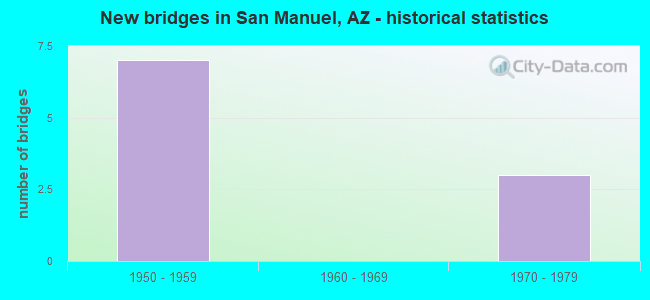
- New bridges - historical statistics
- 71950-1959
- 31970-1979


- Bridge Condition - Superstructure
- 50.0%Very good
- 50.0%Fair

- Bridge Condition - Substructure
- 50.0%Good
- 50.0%Fair

- Bridge Condition - Channel
- 28.6%Good
- 57.1%Satisfactory
- 14.3%Fair

- Bridge Condition - Culverts
- 50.0%Good
- 50.0%Satisfactory
Find on map >> Show street view
Structure Number: 499, Location: at Jct with Old SR 76 (Lat: 32.664100, Lng: -110.683300), Route carried "on" structure: State highway 77, Year Built: 1957, Status: Open, Structure Length: 2.93m (9.61ft), Average Daily Traffic: 3,517 (year 2019), Truck Traffic: 10%, Average Future Daily Traffic: 10,097 (year 2040), Design Load: HS 20, Features Intersected: Old SR76
Minimum Vertical Clearance: 30+ m (98+ ft), Kilometerpoint: 175.660, Lanes on structure: 2, Lanes under structure: 2, Owner: State Highway Agency, Approaching Roadway Width: 12.2m (40.0ft), Material/Design: Steel, Design/Construction: Stringer/Multi-beam, Number Of Spans In Main Unit: 3, Number Of Approach Spans: 2, Length of Maximum Span: 13.7m (44.9ft), Curb or Sidewalk Widths: Left: 0.5m (1.6ft), Right: 0.5m (1.6ft), Curb-To-Curb Width: 12.2m (40.0ft), Out-to-Out Width: 13.7m (44.9ft)
Condition: Deck: Satisfactory, Superstructure: Fair, Substructure: Fair, Operating Rating: 76.2 metric tons, Method Used To Determine Operating Rating: Load Factor (LF), Inventory Rating: 45.4 metric tons, Method Used To Determine Inventory Rating: Load Factor (LF), Structural Evaluation: Somewhat better than minimum adequacy, Deck Geometry: Equal to present minimum criteria, Underclear: High priority of replacement, Approach Roadway Alignment: Equal to present minimum criteria, Length Of Structure Improvement: 3.75m (12.30ft), Designated Inspection Frequency: Every 24 months, Inspection Date: July 2021, Total Project Cost: $1,000 ( Estimate for 2021), Deck Structure Type: Concrete Cast-file-Place, Wearing Surface/Protective System: Wearing Surface: Monolithic Concrete
Find on map >> Show street view
Structure Number: 7709, Location: 8.9 mi S Jct SR 77 (Lat: 32.575136, Lng: -110.584011), Route carried "on" structure: County highway , Year Built: 1971, Status: Open, Structure Length: 6.34m (20.80ft), Average Daily Traffic: 199 (year 2020), Truck Traffic: 1%, Average Future Daily Traffic: 209 (year 2040), Design Load: HS 20, Features Intersected: Peppersauce Wash, Facility Carried by Structure: Reddington Drive
Minimum Vertical Clearance: 30+ m (98+ ft), Kilometerpoint: 0.000, Lanes on structure: 2, Owner: County Highway Agency, Approaching Roadway Width: 12.2m (40.0ft), Skew: 2 degrees, Material/Design: Prestressed concrete continuous, Design/Construction: Stringer/Multi-beam, Number Of Spans In Main Unit: 3, Length of Maximum Span: 21.0m (68.9ft), Curb-To-Curb Width: 12.2m (40.0ft), Out-to-Out Width: 13.0m (42.7ft)
Condition: Deck: Satisfactory, Superstructure: Very good, Substructure: Good, Channel: Good, Operating Rating: 81.6 metric tons, Method Used To Determine Operating Rating: Load Factor (LF), Inventory Rating: 49.0 metric tons, Method Used To Determine Inventory Rating: Load Factor (LF), Structural Evaluation: Better than present minimum criteria, Deck Geometry: Superior to present desirable criteria, Waterway Adequacy: Equal to present desirable criteria, Approach Roadway Alignment: Equal to present desirable criteria, Designated Inspection Frequency: Every 24 months, Inspection Date: November 2021, Deck Structure Type: Concrete Cast-file-Place, Wearing Surface/Protective System: Wearing Surface: Monolithic Concrete
Find on map >> Show street view
Structure Number: 771, Location: 6.9 mi S Jct SR 77 (Lat: 32.602700, Lng: -110.618700), Route carried "on" structure: County highway , Year Built: 1971, Status: Open, Structure Length: 2.26m (7.41ft), Average Daily Traffic: 283 (year 2020), Truck Traffic: 5%, Average Future Daily Traffic: 293 (year 2040), Design Load: HS 20, Features Intersected: Wash, Facility Carried by Structure: San Man-Tiger Hwy
Minimum Vertical Clearance: 30+ m (98+ ft), Kilometerpoint: 0.000, Lanes on structure: 2, Owner: County Highway Agency, Approaching Roadway Width: 12.2m (40.0ft), Skew: 3 degrees, Material/Design: Concrete continuous, Design/Construction: Culvert, Number Of Spans In Main Unit: 6, Length of Maximum Span: 3.0m (9.8ft)
Condition: Channel: Good, Culverts: Satisfactory, Operating Rating: 89.8 metric tons, Method Used To Determine Operating Rating: Load Factor (LF), Inventory Rating: 89.8 metric tons, Method Used To Determine Inventory Rating: Load Factor (LF), Structural Evaluation: Equal to present minimum criteria, Waterway Adequacy: Equal to present desirable criteria, Approach Roadway Alignment: Equal to present desirable criteria, Designated Inspection Frequency: Every 48 months, Inspection Date: November 2021
Find on map >> Show street view
Structure Number: 7711, Location: 6.1 mi S Jct SR 77 (Lat: 32.602700, Lng: -110.618700), Route carried "on" structure: County highway , Year Built: 1971, Status: Open, Structure Length: 1.31m (4.30ft), Average Daily Traffic: 659 (year 2020), Truck Traffic: 10%, Average Future Daily Traffic: 669 (year 2040), Design Load: HS 20, Features Intersected: Wash, Facility Carried by Structure: San Man-Tiger Hwy
Minimum Vertical Clearance: 30+ m (98+ ft), Kilometerpoint: 0.000, Lanes on structure: 2, Owner: County Highway Agency, Approaching Roadway Width: 12.2m (40.0ft), Material/Design: Concrete continuous, Design/Construction: Culvert, Number Of Spans In Main Unit: 4, Length of Maximum Span: 3.0m (9.8ft)
Condition: Channel: Fair, Culverts: Satisfactory, Operating Rating: 89.8 metric tons, Method Used To Determine Operating Rating: Load Factor (LF), Inventory Rating: 89.8 metric tons, Method Used To Determine Inventory Rating: Load Factor (LF), Structural Evaluation: Equal to present minimum criteria, Waterway Adequacy: Equal to present minimum criteria, Approach Roadway Alignment: Equal to present desirable criteria, Designated Inspection Frequency: Every 48 months, Inspection Date: November 2021
Find on map >> Show street view
Structure Number: 7712, Location: 4.8 mi S Jct SR 77 (Lat: 32.617700, Lng: -110.630800), Route carried "on" structure: County highway , Year Built: 1956, Status: Open, Structure Length: 1.95m (6.40ft), Average Daily Traffic: 3,072 (year 2020), Truck Traffic: 10%, Average Future Daily Traffic: 3,082 (year 2040), Design Load: HS 20, Features Intersected: Big Wash, Facility Carried by Structure: San Man-Tiger Hwy
Minimum Vertical Clearance: 30+ m (98+ ft), Kilometerpoint: 0.000, Lanes on structure: 2, Owner: County Highway Agency, Approaching Roadway Width: 11.6m (38.1ft), Material/Design: Concrete continuous, Design/Construction: Culvert, Number Of Spans In Main Unit: 6, Length of Maximum Span: 3.0m (9.8ft)
Condition: Channel: Satisfactory, Culverts: Good, Operating Rating: 89.8 metric tons, Method Used To Determine Operating Rating: Load Factor (LF), Inventory Rating: 89.8 metric tons, Method Used To Determine Inventory Rating: Load Factor (LF), Structural Evaluation: Better than present minimum criteria, Waterway Adequacy: Equal to present minimum criteria, Approach Roadway Alignment: Equal to present desirable criteria, Designated Inspection Frequency: Every 48 months, Inspection Date: November 2021
Find on map >> Show street view
Structure Number: 7713, Location: 2.7 mi S Jct SR 77 (Lat: 32.634900, Lng: -110.659200), Route carried "on" structure: County highway , Year Built: 1956, Status: Open, Structure Length: 0.98m (3.22ft), Average Daily Traffic: 2,989 (year 2020), Truck Traffic: 10%, Average Future Daily Traffic: 2,999 (year 2040), Design Load: HS 20, Features Intersected: Wash, Facility Carried by Structure: San Man-Tiger Hwy
Minimum Vertical Clearance: 30+ m (98+ ft), Kilometerpoint: 0.000, Lanes on structure: 2, Owner: County Highway Agency, Approaching Roadway Width: 9.8m (32.2ft), Material/Design: Concrete continuous, Design/Construction: Culvert, Number Of Spans In Main Unit: 3, Length of Maximum Span: 3.0m (9.8ft)
Condition: Channel: Satisfactory, Culverts: Satisfactory, Operating Rating: 89.8 metric tons, Method Used To Determine Operating Rating: Load Factor (LF), Inventory Rating: 76.2 metric tons, Method Used To Determine Inventory Rating: Load Factor (LF), Structural Evaluation: Equal to present minimum criteria, Waterway Adequacy: Equal to present desirable criteria, Approach Roadway Alignment: Equal to present desirable criteria, Designated Inspection Frequency: Every 48 months, Inspection Date: November 2021
Find on map >> Show street view
Structure Number: 7714, Location: 2.0 mi S Jct SR 77 (Lat: 32.644444, Lng: -110.675000), Route carried "on" structure: County highway , Year Built: 1956, Status: Open, Structure Length: 1.95m (6.40ft), Average Daily Traffic: 2,965 (year 2020), Truck Traffic: 10%, Average Future Daily Traffic: 2,975 (year 2040), Design Load: HS 20, Features Intersected: Smelter Wash, Facility Carried by Structure: San Man-Tiger Hwy
Minimum Vertical Clearance: 30+ m (98+ ft), Kilometerpoint: 0.000, Lanes on structure: 2, Owner: County Highway Agency, Approaching Roadway Width: 11.6m (38.1ft), Material/Design: Concrete continuous, Design/Construction: Culvert, Number Of Spans In Main Unit: 5, Length of Maximum Span: 3.7m (12.1ft)
Condition: Channel: Satisfactory, Culverts: Good, Operating Rating: 89.8 metric tons, Method Used To Determine Operating Rating: Load Factor (LF), Inventory Rating: 84.4 metric tons, Method Used To Determine Inventory Rating: Load Factor (LF), Structural Evaluation: Better than present minimum criteria, Waterway Adequacy: Equal to present desirable criteria, Approach Roadway Alignment: Equal to present desirable criteria, Designated Inspection Frequency: Every 48 months, Inspection Date: November 2021
Find on map >> Show street view
Structure Number: 7715, Location: 0.6 mi S Jct SR 77 (Lat: 32.661111, Lng: -110.688889), Route carried "on" structure: County highway , Year Built: 1956, Status: Open, Structure Length: 1.95m (6.40ft), Average Daily Traffic: 2,965 (year 2020), Truck Traffic: 10%, Average Future Daily Traffic: 2,975 (year 2040), Design Load: HS 20, Features Intersected: Cottonwood Wash, Facility Carried by Structure: San Man-Tiger Hwy
Minimum Vertical Clearance: 30+ m (98+ ft), Kilometerpoint: 0.000, Lanes on structure: 2, Owner: County Highway Agency, Approaching Roadway Width: 11.6m (38.1ft), Material/Design: Concrete continuous, Design/Construction: Culvert, Number Of Spans In Main Unit: 5, Length of Maximum Span: 3.7m (12.1ft)
Condition: Channel: Satisfactory, Culverts: Good, Operating Rating: 89.8 metric tons, Method Used To Determine Operating Rating: Load Factor (LF), Inventory Rating: 89.8 metric tons, Method Used To Determine Inventory Rating: Load Factor (LF), Structural Evaluation: Better than present minimum criteria, Waterway Adequacy: Equal to present desirable criteria, Approach Roadway Alignment: Equal to present desirable criteria, Designated Inspection Frequency: Every 48 months, Inspection Date: November 2021
Find on map >> Show street view
Structure Number: 499, Location: at Jct with Old SR 76 (Lat: 32.664100, Lng: -110.683300), Route carried "under" structure: County highway , Year Built: 1957, Structure Length: 0. m, Average Daily Traffic: 3,900 (year 2020), Truck Traffic: 7%, Features Intersected: Old SR76, Facility Carried by Structure: SR 77
Minimum Vertical Clearance: 4.75m (15.58ft), Kilometerpoint: 0.000, Lanes on structure: 2, Lanes under structure: 2, Material/Design: Steel, Design/Construction: Stringer/Multi-beam, Length of Maximum Span: 13.7m (44.9ft)
Find on map >> Show street view
Structure Number: 5, Location: 0.2 mi N of Jct Old SR 76 (Lat: 32.664700, Lng: -110.681200), Route carried "under" structure: ServiceOther road , Year Built: 1957, Structure Length: 0. m, Average Daily Traffic: 2 (year 2021), Features Intersected: Abandoned Railroad, Facility Carried by Structure: SR 77
Minimum Vertical Clearance: 7.18m (23.56ft), Kilometerpoint: 0.000, Lanes on structure: 3, Lanes under structure: 1, Material/Design: Steel continuous, Design/Construction: Stringer/Multi-beam, Length of Maximum Span: 18.3m (60.0ft)