Bridge Statistics for San Luis, Colorado (CO)
Condition, Traffic, Stress, Structural Evaluation, Project Costs
- National Bridge Inventory (NBI) Statistics
- 10Number of bridges
- 59ft / 18.0mTotal length
- $217,000Total costs
- 4,157Total average daily traffic
- 119Total average daily truck traffic
- 5,691Total future (year 2038) average daily traffic
- National Bridge Inventory (NBI) Registered Bridges for San Luis
- No street view available for this location
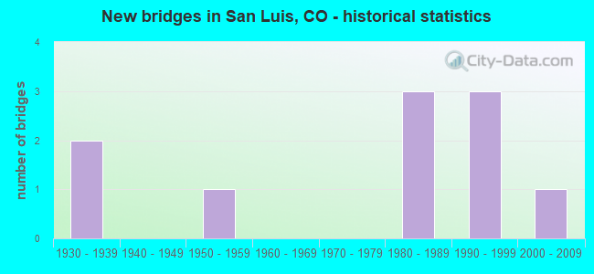
- New bridges - historical statistics
- 21930-1939
- 11950-1959
- 31980-1989
- 31990-1999
- 12000-2009

- Bridge Condition - Deck
- 22.2%Good
- 44.4%Satisfactory
- 33.3%Fair

- Bridge Condition - Superstructure
- 33.3%Good
- 55.6%Satisfactory
- 11.1%Fair

- Bridge Condition - Substructure
- 55.6%Good
- 11.1%Satisfactory
- 33.3%Fair

- Bridge Condition - Channel
- 20.0%Very good
- 60.0%Good
- 20.0%Satisfactory
Find on map >> Show street view
Structure Number: CS152-0.4-S159, Location: 0.4 MI E OF SAN LUIS (Lat: 37.195058, Lng: -105.418131), Route carried "on" structure: County highway , Year Built: 2006, Status: Open, Structure Length: 1.57m (5.15ft), Average Daily Traffic: 1,429 (year 2018), Truck Traffic: 2%, Average Future Daily Traffic: 2,101 (year 2038), Design Load: HS 20, Features Intersected: UNNAMED DRAINAGE, Facility Carried by Structure: COUNTY ROAD P.6
Minimum Vertical Clearance: 30+ m (98+ ft), Kilometerpoint: 3.315, Lanes on structure: 2, Owner: County Highway Agency, Approaching Roadway Width: 7.0m (23.0ft), Material/Design: Steel, Design/Construction: Stringer/Multi-beam, Number Of Spans In Main Unit: 1, Length of Maximum Span: 14.4m (47.2ft), Curb-To-Curb Width: 12.2m (40.0ft), Out-to-Out Width: 12.8m (42.0ft)
Condition: Deck: Good, Superstructure: Good, Substructure: Satisfactory, Channel: Good, Operating Rating: 54.8 metric tons, Method Used To Determine Operating Rating: Load Factor (LF), Inventory Rating: 32.8 metric tons, Method Used To Determine Inventory Rating: Load Factor (LF), Structural Evaluation: Equal to present minimum criteria, Deck Geometry: Better than present minimum criteria, Waterway Adequacy: Equal to present desirable criteria, Approach Roadway Alignment: Equal to present desirable criteria, Designated Inspection Frequency: Every 24 months, Inspection Date: March 2021, Deck Structure Type: Concrete Cast-file-Place, Wearing Surface/Protective System: Wearing Surface: Bituminous
Find on map >> Show street view
Structure Number: CS152A-S0.1152A, Location: .2 MI SE OF CR L.7 (Lat: 37.159897, Lng: -105.381567), Route carried "on" structure: County highway , Year Built: 1992, Status: Open, Structure Length: 1.95m (6.40ft), Average Daily Traffic: 154 (year 2018), Average Future Daily Traffic: 227 (year 2038), Features Intersected: CULEBRA CREEK, Facility Carried by Structure: COUNTY ROAD M.5
Minimum Vertical Clearance: 30+ m (98+ ft), Kilometerpoint: 0.039, Lanes on structure: 2, Owner: County Highway Agency, Approaching Roadway Width: 6.7m (22.0ft), Material/Design: Steel, Design/Construction: Stringer/Multi-beam, Number Of Spans In Main Unit: 1, Length of Maximum Span: 18.3m (60.0ft), Curb-To-Curb Width: 7.3m (24.0ft), Out-to-Out Width: 8.0m (26.2ft)
Condition: Deck: Good, Superstructure: Good, Substructure: Good, Channel: Good, Operating Rating: 55.8 metric tons, Method Used To Determine Operating Rating: Load Factor (LF), Inventory Rating: 33.4 metric tons, Method Used To Determine Inventory Rating: Load Factor (LF), Structural Evaluation: Better than present minimum criteria, Deck Geometry: Somewhat better than minimum adequacy, Waterway Adequacy: Equal to present desirable criteria, Approach Roadway Alignment: High priority of corrective action, Designated Inspection Frequency: Every 24 months, Inspection Date: March 2021, Deck Structure Type: Concrete Cast-file-Place, Wearing Surface/Protective System: Wearing Surface: Bituminous
Find on map >> Show street view
Structure Number: CS242-S0.4-SMME, Location: Just SE OF CR L.7 (Lat: 37.151569, Lng: -105.398911), Route carried "on" structure: County highway , Year Built: 1955, Status: Open, Structure Length: 2.88m (9.45ft), Average Daily Traffic: 400 (year 2018), Truck Traffic: 2%, Average Future Daily Traffic: 588 (year 2038), Features Intersected: CULEBRA CREEK, Facility Carried by Structure: COUNTY ROAD 21
Minimum Vertical Clearance: 30+ m (98+ ft), Kilometerpoint: 18.372, Lanes on structure: 2, Owner: County Highway Agency, Approaching Roadway Width: 7.6m (24.9ft), Material/Design: Concrete, Design/Construction: Tee Beam, Number Of Spans In Main Unit: 3, Length of Maximum Span: 8.7m (28.5ft), Curb-To-Curb Width: 7.8m (25.6ft), Out-to-Out Width: 8.6m (28.2ft)
Condition: Deck: Satisfactory, Superstructure: Fair, Substructure: Fair, Channel: Good, Operating Rating: 36.3 metric tons, Method Used To Determine Operating Rating: Field evaluation and documented engineering judgment, Inventory Rating: 32.7 metric tons, Method Used To Determine Inventory Rating: Field evaluation and documented engineering judgment, Structural Evaluation: Somewhat better than minimum adequacy, Deck Geometry: Somewhat better than minimum adequacy, Waterway Adequacy: Equal to present desirable criteria, Approach Roadway Alignment: Equal to present desirable criteria, Designated Inspection Frequency: Every 24 months, Inspection Date: March 2021, Deck Structure Type: Concrete Cast-file-Place, Wearing Surface/Protective System: Wearing Surface: Bituminous
Find on map >> Show street view
Structure Number: CS242D-0.1-152A, Location: BETWEEN CR L.7 AND M.5 (Lat: 37.161133, Lng: -105.374703), Route carried "on" structure: County highway , Year Built: 1984, Status: Open, Structure Length: 1.23m (4.04ft), Average Daily Traffic: 150 (year 2018), Average Future Daily Traffic: 221 (year 2038), Features Intersected: CULEBRA CREEK, Facility Carried by Structure: COUNTY ROAD 22.3
Minimum Vertical Clearance: 30+ m (98+ ft), Kilometerpoint: 4.617, Lanes on structure: 2, Owner: County Highway Agency, Approaching Roadway Width: 6.7m (22.0ft), Skew: 1 degrees, Material/Design: Steel, Design/Construction: Stringer/Multi-beam, Number Of Spans In Main Unit: 2, Length of Maximum Span: 5.3m (17.4ft), Curb-To-Curb Width: 8.3m (27.2ft), Out-to-Out Width: 9.0m (29.5ft)
Condition: Deck: Fair, Superstructure: Satisfactory, Substructure: Fair, Channel: Good, Operating Rating: 36.1 metric tons, Method Used To Determine Operating Rating: Load Factor (LF), Inventory Rating: 21.6 metric tons, Method Used To Determine Inventory Rating: Load Factor (LF), Structural Evaluation: Somewhat better than minimum adequacy, Deck Geometry: Somewhat better than minimum adequacy, Waterway Adequacy: Equal to present desirable criteria, Approach Roadway Alignment: Equal to present desirable criteria, Designated Inspection Frequency: Every 24 months, Inspection Date: March 2021, Deck Structure Type: Corrugated Steel, Wearing Surface/Protective System: Wearing Surface: Bituminous
Find on map >> Show street view
Structure Number: CSJACQ-S08-142A, Location: 1 MI S OF CR SH 142 (Lat: 37.205706, Lng: -105.485244), Route carried "on" structure: County highway , Year Built: 1987, Status: Open, Structure Length: 1.97m (6.46ft), Average Daily Traffic: 16 (year 2018), Average Future Daily Traffic: 24 (year 2038), Features Intersected: EASTDALE CANAL, Facility Carried by Structure: COUNTY ROAD 16
Minimum Vertical Clearance: 30+ m (98+ ft), Kilometerpoint: 1.558, Lanes on structure: 2, Owner: County Highway Agency, Approaching Roadway Width: 5.5m (18.0ft), Material/Design: Steel, Design/Construction: Stringer/Multi-beam, Number Of Spans In Main Unit: 1, Length of Maximum Span: 18.1m (59.4ft), Curb-To-Curb Width: 7.2m (23.6ft), Out-to-Out Width: 7.9m (25.9ft)
Condition: Deck: Satisfactory, Superstructure: Satisfactory, Substructure: Good, Channel: Good, Operating Rating: 62.4 metric tons, Method Used To Determine Operating Rating: Load Factor (LF), Inventory Rating: 37.4 metric tons, Method Used To Determine Inventory Rating: Load Factor (LF), Structural Evaluation: Equal to present minimum criteria, Deck Geometry: Somewhat better than minimum adequacy, Waterway Adequacy: Equal to present desirable criteria, Approach Roadway Alignment: Somewhat better than minimum adequacy, Designated Inspection Frequency: Every 24 months, Inspection Date: March 2021, Deck Structure Type: Concrete Cast-file-Place, Wearing Surface/Protective System: Wearing Surface: Monolithic Concrete
Find on map >> Show street view
Structure Number: CSSMME-0.6-242A, Location: 0.5 MI SW OF CR 21 (Lat: 37.148836, Lng: -105.410958), Route carried "on" structure: County highway , Year Built: 1988, Status: Open, Structure Length: 1.45m (4.76ft), Average Daily Traffic: 73 (year 2018), Average Future Daily Traffic: 107 (year 2038), Features Intersected: CULEBRA CREEK, Facility Carried by Structure: COUNTY ROAD 19
Minimum Vertical Clearance: 30+ m (98+ ft), Kilometerpoint: 0.965, Lanes on structure: 2, Owner: County Highway Agency, Approaching Roadway Width: 7.0m (23.0ft), Material/Design: Steel, Design/Construction: Stringer/Multi-beam, Number Of Spans In Main Unit: 1, Length of Maximum Span: 13.0m (42.7ft), Curb-To-Curb Width: 7.4m (24.3ft), Out-to-Out Width: 8.0m (26.2ft)
Condition: Deck: Fair, Superstructure: Satisfactory, Substructure: Good, Channel: Very good, Operating Rating: 70.2 metric tons, Method Used To Determine Operating Rating: Load Factor (LF), Inventory Rating: 42.0 metric tons, Method Used To Determine Inventory Rating: Load Factor (LF), Structural Evaluation: Equal to present minimum criteria, Deck Geometry: Equal to present minimum criteria, Waterway Adequacy: Equal to present desirable criteria, Approach Roadway Alignment: Equal to present desirable criteria, Designated Inspection Frequency: Every 24 months, Inspection Date: March 2021, Deck Structure Type: Concrete Cast-file-Place, Wearing Surface/Protective System: Wearing Surface: Monolithic Concrete
Find on map >> Show street view
Structure Number: P-15-C, Location: S. EDGE OF SAN LUIS (Lat: 37.193667, Lng: -105.431028), Route carried "on" structure: State highway 159A, Year Built: 1936, Status: Open, Structure Length: 3.66m (12.01ft), Average Daily Traffic: 800 (year 2020), Truck Traffic: 6%, Average Future Daily Traffic: 896 (year 2040), Design Load: H 15, Features Intersected: CULEBRA CREEK, Facility Carried by Structure: SH 159 ML
Minimum Vertical Clearance: 30+ m (98+ ft), Kilometerpoint: 27.941, Lanes on structure: 2, Base Highway Network: Yes, Owner: State Highway Agency, Approaching Roadway Width: 11.0m (36.1ft), Skew: 9 degrees, Material/Design: Steel, Design/Construction: Stringer/Multi-beam, Number Of Spans In Main Unit: 3, Length of Maximum Span: 14.9m (48.9ft), Curb or Sidewalk Widths: Left: 0.2m (0.7ft), Right: 0.2m (0.7ft), Curb-To-Curb Width: 9.1m (29.9ft), Out-to-Out Width: 10.2m (33.5ft)
Condition: Deck: Fair, Superstructure: Satisfactory, Substructure: Fair, Channel: Good, Operating Rating: 31.8 metric tons, Method Used To Determine Operating Rating: Load Factor (LF), Inventory Rating: 19.1 metric tons, Method Used To Determine Inventory Rating: Load Factor (LF), Structural Evaluation: Somewhat better than minimum adequacy, Deck Geometry: Equal to present minimum criteria, Waterway Adequacy: Equal to present desirable criteria, Approach Roadway Alignment: Better than present minimum criteria, Length Of Structure Improvement: 3.66m (12.01ft), Designated Inspection Frequency: Every 24 months, Inspection Date: July 2021, Bridge Improvement Cost: $145,000, Roadway Improvement Cost: $14,000, Total Project Cost: $217,000, Deck Structure Type: Concrete Cast-file-Place, Wearing Surface/Protective System: Wearing Surface: Bituminous
Find on map >> Show street view
Structure Number: P-15-D, Location: IN SAN LUIS (Lat: 37.200206, Lng: -105.426631), Route carried "on" structure: State highway 142A, Year Built: 1936, Status: Open, Structure Length: 1.10m (3.61ft), Average Daily Traffic: 440 (year 2020), Truck Traffic: 5%, Average Future Daily Traffic: 506 (year 2040), Design Load: HS 20+Mod, Features Intersected: RITO SECO CREEK, Facility Carried by Structure: SH 142 ML
Minimum Vertical Clearance: 30+ m (98+ ft), Kilometerpoint: 53.882, Lanes on structure: 2, Base Highway Network: Yes, Owner: State Highway Agency, Approaching Roadway Width: 6.7m (22.0ft), Skew: 3 degrees, Material/Design: Steel, Design/Construction: Culvert, Number Of Spans In Main Unit: 2, Length of Maximum Span: 5.0m (16.4ft), Curb or Sidewalk Widths: Left: 0.2m (0.7ft), Right: 0.2m (0.7ft), Curb-To-Curb Width: 9.1m (29.9ft), Out-to-Out Width: 10.8m (35.4ft)
Condition: Channel: Very good, Culverts: Good, Structural Evaluation: Better than present minimum criteria, Deck Geometry: Equal to present minimum criteria, Waterway Adequacy: Equal to present desirable criteria, Approach Roadway Alignment: Equal to present desirable criteria, Designated Inspection Frequency: Every 24 months, Inspection Date: March 2021
Find on map >> Show street view
Structure Number: SAN LUIS-1A, Location: 50 FT E OF SH 159 (Lat: 37.201731, Lng: -105.425428), Route carried "on" structure: City street , Year Built: 1990, Status: Open, Structure Length: 1.10m (3.61ft), Average Daily Traffic: 377 (year 2018), Truck Traffic: 2%, Average Future Daily Traffic: 554 (year 2038), Design Load: HS 20, Features Intersected: RITO SECO, Facility Carried by Structure: 6TH STREET
Minimum Vertical Clearance: 30+ m (98+ ft), Kilometerpoint: 0.005, Lanes on structure: 2, Owner: Town or Township Highway Agency, Approaching Roadway Width: 7.6m (24.9ft), Material/Design: Concrete continuous, Design/Construction: Slab, Number Of Spans In Main Unit: 2, Length of Maximum Span: 4.8m (15.7ft), Curb-To-Curb Width: 8.6m (28.2ft), Out-to-Out Width: 9.7m (31.8ft)
Condition: Deck: Satisfactory, Superstructure: Satisfactory, Substructure: Good, Channel: Satisfactory, Operating Rating: 99.6 metric tons, Method Used To Determine Operating Rating: Load Factor (LF), Inventory Rating: 59.6 metric tons, Method Used To Determine Inventory Rating: Load Factor (LF), Structural Evaluation: Equal to present minimum criteria, Deck Geometry: Equal to present minimum criteria, Waterway Adequacy: Better than present minimum criteria, Approach Roadway Alignment: Equal to present desirable criteria, Designated Inspection Frequency: Every 24 months, Inspection Date: March 2021, Deck Structure Type: Concrete Cast-file-Place, Wearing Surface/Protective System: Wearing Surface: Bituminous, Deck Protection: Epoxy Coated Reinforcing
Find on map >> Show street view
Structure Number: SAN LUIS-2A, Location: IN TOWN OF SAN LUIS (Lat: 37.199303, Lng: -105.427739), Route carried "on" structure: City street , Year Built: 1990, Status: Open, Structure Length: 1.11m (3.64ft), Average Daily Traffic: 318 (year 2018), Truck Traffic: 2%, Average Future Daily Traffic: 467 (year 2038), Design Load: HS 20, Features Intersected: RITO SECO, Facility Carried by Structure: ARCHIE STREET
Minimum Vertical Clearance: 30+ m (98+ ft), Kilometerpoint: 0.126, Lanes on structure: 2, Owner: Town or Township Highway Agency, Approaching Roadway Width: 6.1m (20.0ft), Material/Design: Steel, Design/Construction: Stringer/Multi-beam, Number Of Spans In Main Unit: 1, Length of Maximum Span: 9.6m (31.5ft), Curb-To-Curb Width: 7.3m (24.0ft), Out-to-Out Width: 8.4m (27.6ft)
Condition: Deck: Satisfactory, Superstructure: Good, Substructure: Good, Channel: Satisfactory, Operating Rating: 78.5 metric tons, Method Used To Determine Operating Rating: Load Factor (LF), Inventory Rating: 47.1 metric tons, Method Used To Determine Inventory Rating: Load Factor (LF), Structural Evaluation: Better than present minimum criteria, Deck Geometry: Somewhat better than minimum adequacy, Waterway Adequacy: Better than present minimum criteria, Approach Roadway Alignment: Equal to present minimum criteria, Designated Inspection Frequency: Every 24 months, Inspection Date: March 2021, Deck Structure Type: Concrete Cast-file-Place, Wearing Surface/Protective System: Wearing Surface: Monolithic Concrete, Deck Protection: Epoxy Coated Reinforcing