Bridge Statistics for San Juan Capistrano, California (CA)
Condition, Traffic, Stress, Structural Evaluation, Project Costs
- National Bridge Inventory (NBI) Statistics
- 26Number of bridges
- 755ft / 230mTotal length
- $3,470,000Total costs
- 2,073,106Total average daily traffic
- 80,807Total average daily truck traffic
- National Bridge Inventory (NBI) Registered Bridges for San Juan Capistrano
- No street view available for this location

- New bridges - historical statistics
- 11920-1929
- 11940-1949
- 71950-1959
- 21960-1969
- 31970-1979
- 11980-1989
- 71990-1999
- 42010-2019
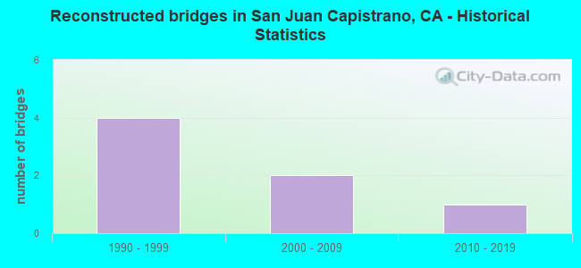
- Reconstructed bridges - Historical Statistics
- 41990-1999
- 22000-2009
- 12010-2019
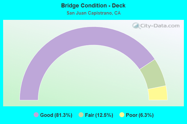
- Bridge Condition - Deck
- 81.3%Good
- 12.5%Fair
- 6.3%Poor
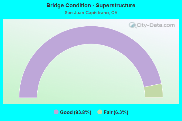
- Bridge Condition - Superstructure
- 93.8%Good
- 6.3%Fair
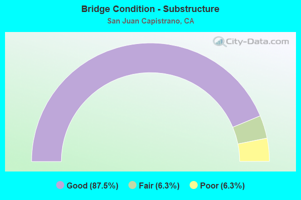
- Bridge Condition - Substructure
- 87.5%Good
- 6.3%Fair
- 6.3%Poor
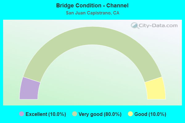
- Bridge Condition - Channel
- 10.0%Excellent
- 80.0%Very good
- 10.0%Good
Find on map >> Show street view
Structure Number: 55 0063, Location: 12-ORA-074-12.34-SJCP (Lat: 33.589019, Lng: -117.515719), Route carried "on" structure: State highway 74, Year Built: 1991, Status: Open, Structure Length: 3.20m (10.50ft), Average Daily Traffic: 9,800 (year 2012), Truck Traffic: 5%, Average Future Daily Traffic: 23,300 (year 2040), Design Load: HS 20+Mod, Features Intersected: HOT SPRINGS CANYON
Minimum Vertical Clearance: 30+ m (98+ ft), Kilometerpoint: 12.340, Lanes on structure: 2, Owner: State Highway Agency, Approaching Roadway Width: 12.2m (40.0ft), Skew: 1 degrees, Material/Design: Prestressed concrete, Design/Construction: Box Beam or Girders - Multiple, Number Of Spans In Main Unit: 1, Length of Maximum Span: 30.5m (100.1ft), Curb-To-Curb Width: 12.2m (40.0ft), Out-to-Out Width: 13.3m (43.6ft)
Condition: Deck: Fair, Superstructure: Good, Substructure: Fair, Channel: Good, Operating Rating: 54.1 metric tons, Method Used To Determine Operating Rating: Assigned rating based on Load Factor Design (LFD) reported in metric tons, Inventory Rating: 32.4 metric tons, Method Used To Determine Inventory Rating: Assigned rating based on Load Factor Design (LFD) reported in metric tons, Structural Evaluation: Somewhat better than minimum adequacy, Deck Geometry: Somewhat better than minimum adequacy, Waterway Adequacy: Better than present minimum criteria, Approach Roadway Alignment: Better than present minimum criteria, Designated Inspection Frequency: Every 24 months, Inspection Date: July 2021, Deck Structure Type: Concrete Cast-file-Place
Find on map >> Show street view
Structure Number: 55 0064, Location: 12-ORA-074-13.29-SJCP (Lat: 33.590386, Lng: -117.501956), Route carried "on" structure: State highway 74, Year Built: 1929, Status: Open, Structure Length: 5.49m (18.01ft), Average Daily Traffic: 9,800 (year 2012), Truck Traffic: 7%, Average Future Daily Traffic: 13,400 (year 2040), Features Intersected: SAN JUAN CANYON
Minimum Vertical Clearance: 30+ m (98+ ft), Kilometerpoint: 13.290, Lanes on structure: 2, Owner: State Highway Agency, Approaching Roadway Width: 6.7m (22.0ft), Material/Design: Concrete, Design/Construction: Arch - Deck, Number Of Spans In Main Unit: 1, Number Of Approach Spans: 2, Length of Maximum Span: 45.4m (149.0ft), Curb-To-Curb Width: 6.7m (22.0ft), Out-to-Out Width: 7.7m (25.3ft)
Condition: Deck: Good, Superstructure: Good, Substructure: Poor, Channel: Very good, Operating Rating: 27.2 metric tons, Method Used To Determine Operating Rating: Load Factor (LF), Inventory Rating: 16.2 metric tons, Method Used To Determine Inventory Rating: Load Factor (LF), Structural Evaluation: Meets minimum limits, Deck Geometry: High priority of replacement, Waterway Adequacy: Equal to present desirable criteria, Approach Roadway Alignment: Equal to present minimum criteria, Length Of Structure Improvement: 5.49m (18.01ft), Designated Inspection Frequency: Every 24 months, Inspection Date: July 2021, Bridge Improvement Cost: $972,000, Roadway Improvement Cost: $194,000, Total Project Cost: $1,634,000 ( Estimate for 2020), Deck Structure Type: Concrete Cast-file-Place, Wearing Surface/Protective System: Wearing Surface: Integral Concrete
Find on map >> Show street view
Structure Number: 55 0221, Location: 12-ORA-005-16.36-LGNH (Lat: 33.596525, Lng: -117.674289), Route carried "on" structure: Interstate 5, Year Built: 1959, Year Reconstructed: 1996, Status: Open, Structure Length: 6.66m (21.85ft), Average Daily Traffic: 344,000 (year 2016), Truck Traffic: 4%, Average Future Daily Traffic: 357,059 (year 2041), Design Load: HS 20, Features Intersected: BNSF RY,AMTRAK,METROLINK
Minimum Vertical Clearance: 30+ m (98+ ft), Kilometerpoint: 16.360, Lanes on structure: 11, Base Highway Network: Yes (, Subroute: 1), Owner: State Highway Agency, Approaching Roadway Width: 53.3m (174.9ft), Skew: 35 degrees, Material/Design: Steel, Design/Construction: Stringer/Multi-beam, Number Of Spans In Main Unit: 3, Length of Maximum Span: 23.3m (76.4ft), Curb-To-Curb Width: 53.3m (174.9ft), Out-to-Out Width: 54.5m (178.8ft)
Condition: Deck: Good, Superstructure: Fair, Substructure: Good, Operating Rating: 30.5 metric tons, Method Used To Determine Operating Rating: Load and Resistance Factor Rating (LRFR) rating reported by rating factor(RF) method using HL-93 loadings, Inventory Rating: 23.7 metric tons, Method Used To Determine Inventory Rating: Load and Resistance Factor Rating (LRFR) rating reported by rating factor(RF) method using HL-93 loadings, Structural Evaluation: Somewhat better than minimum adequacy, Deck Geometry: Superior to present desirable criteria, Underclear: Somewhat better than minimum adequacy, Approach Roadway Alignment: Equal to present desirable criteria, Designated Inspection Frequency: Every 24 months, Inspection Date: July 2021, Deck Structure Type: Concrete Cast-file-Place
Find on map >> Show street view
Structure Number: 55 0227, Location: 12-ORA-005-7.34-SJCP (Lat: 33.473706, Lng: -117.674472), Route carried "on" structure: Interstate 5, Year Built: 1960, Year Reconstructed: 2017, Status: Open, Structure Length: 7.62m (25.00ft), Average Daily Traffic: 278,000 (year 2016), Truck Traffic: 4%, Average Future Daily Traffic: 298,413 (year 2043), Design Load: HS 20, Features Intersected: CAMINO CAPISTRANO ONRAMP
Minimum Vertical Clearance: 30+ m (98+ ft), Kilometerpoint: 7.340, Lanes on structure: 10, Lanes under structure: 2, Base Highway Network: Yes (, Subroute: 1), Owner: State Highway Agency, Approaching Roadway Width: 48.7m (159.8ft), Skew: 35 degrees, Material/Design: Concrete continuous, Design/Construction: Tee Beam, Number Of Spans In Main Unit: 4, Length of Maximum Span: 21.0m (68.9ft), Curb-To-Curb Width: 51.3m (168.3ft), Out-to-Out Width: 52.7m (172.9ft)
Condition: Deck: Good, Superstructure: Good, Substructure: Good, Operating Rating: 54.1 metric tons, Method Used To Determine Operating Rating: Assigned rating based on Load Factor Design (LFD) reported in metric tons, Inventory Rating: 32.4 metric tons, Method Used To Determine Inventory Rating: Assigned rating based on Load Factor Design (LFD) reported in metric tons, Structural Evaluation: Better than present minimum criteria, Deck Geometry: Superior to present desirable criteria, Underclear: Meets minimum limits, Approach Roadway Alignment: Equal to present desirable criteria, Designated Inspection Frequency: Every 24 months, Inspection Date: April 2021, Deck Structure Type: Concrete Cast-file-Place
Find on map >> Show street view
Structure Number: 55 0231, Location: 12-ORA-005-10.91-SJCP (Lat: 33.520472, Lng: -117.665361), Route carried "on" structure: Interstate 5, Year Built: 1958, Year Reconstructed: 1996, Status: Open, Structure Length: 3.81m (12.50ft), Average Daily Traffic: 316,000 (year 2016), Truck Traffic: 4%, Average Future Daily Traffic: 343,915 (year 2043), Design Load: HS 20, Features Intersected: JUNIPERO SERRA RD
Minimum Vertical Clearance: 30+ m (98+ ft), Kilometerpoint: 10.910, Lanes on structure: 12, Lanes under structure: 4, Base Highway Network: Yes (, Subroute: 1), Owner: State Highway Agency, Approaching Roadway Width: 58.5m (191.9ft), Skew: 30 degrees, Material/Design: Concrete continuous, Design/Construction: Tee Beam, Number Of Spans In Main Unit: 3, Length of Maximum Span: 19.2m (63.0ft), Curb-To-Curb Width: 58.5m (191.9ft), Out-to-Out Width: 60.2m (197.5ft)
Condition: Deck: Good, Superstructure: Good, Substructure: Good, Operating Rating: 54.1 metric tons, Method Used To Determine Operating Rating: Assigned rating based on Load Factor Design (LFD) reported in metric tons, Inventory Rating: 32.4 metric tons, Method Used To Determine Inventory Rating: Assigned rating based on Load Factor Design (LFD) reported in metric tons, Structural Evaluation: Better than present minimum criteria, Deck Geometry: Superior to present desirable criteria, Underclear: High priority of corrective action, Approach Roadway Alignment: Equal to present desirable criteria, Designated Inspection Frequency: Every 24 months, Inspection Date: April 2021, Deck Structure Type: Concrete Cast-file-Place, Wearing Surface/Protective System: Wearing Surface: Integral Concrete
Find on map >> Show street view
Structure Number: 55 0289, Location: 12-ORA-005-11.45-SJCP (Lat: 33.527928, Lng: -117.669453), Route carried "on" structure: Interstate 5, Year Built: 1959, Year Reconstructed: 1997, Status: Open, Structure Length: 7.28m (23.88ft), Average Daily Traffic: 316,000 (year 2016), Truck Traffic: 4%, Average Future Daily Traffic: 343,915 (year 2043), Design Load: HS 20, Features Intersected: TRABUCO CREEK
Minimum Vertical Clearance: 30+ m (98+ ft), Kilometerpoint: 11.450, Lanes on structure: 12, Base Highway Network: Yes (, Subroute: 1), Owner: State Highway Agency, Approaching Roadway Width: 65.8m (215.9ft), Skew: 34 degrees, Material/Design: Concrete continuous, Design/Construction: Tee Beam, Number Of Spans In Main Unit: 5, Length of Maximum Span: 15.9m (52.2ft), Curb-To-Curb Width: 65.8m (215.9ft), Out-to-Out Width: 67.5m (221.5ft)
Condition: Deck: Good, Superstructure: Good, Substructure: Good, Channel: Very good, Operating Rating: 54.1 metric tons, Method Used To Determine Operating Rating: Assigned rating based on Load Factor Design (LFD) reported in metric tons, Inventory Rating: 32.4 metric tons, Method Used To Determine Inventory Rating: Assigned rating based on Load Factor Design (LFD) reported in metric tons, Structural Evaluation: Better than present minimum criteria, Deck Geometry: Superior to present desirable criteria, Waterway Adequacy: Equal to present desirable criteria, Approach Roadway Alignment: Equal to present desirable criteria, Designated Inspection Frequency: Every 24 months, Inspection Date: April 2021, Deck Structure Type: Concrete Cast-file-Place
Find on map >> Show street view
Structure Number: 55 0298, Location: 12-ORA-005-8.80-SJCP (Lat: 33.491292, Lng: -117.661800), Route carried "on" structure: Interstate 5, Year Built: 1958, Year Reconstructed: 1996, Status: Open, Structure Length: 3.93m (12.89ft), Average Daily Traffic: 285,000 (year 2016), Truck Traffic: 4%, Average Future Daily Traffic: 298,413 (year 2043), Design Load: HS 20, Features Intersected: SAN JUAN CREEK ROAD
Minimum Vertical Clearance: 30+ m (98+ ft), Kilometerpoint: 8.800, Lanes on structure: 13, Lanes under structure: 3, Base Highway Network: Yes (, Subroute: 1), Owner: State Highway Agency, Approaching Roadway Width: 55.3m (181.4ft), Skew: 31 degrees, Material/Design: Concrete continuous, Design/Construction: Tee Beam, Number Of Spans In Main Unit: 3, Length of Maximum Span: 19.8m (65.0ft), Curb-To-Curb Width: 55.3m (181.4ft), Out-to-Out Width: 56.4m (185.0ft)
Condition: Deck: Good, Superstructure: Good, Substructure: Good, Operating Rating: 54.1 metric tons, Method Used To Determine Operating Rating: Assigned rating based on Load Factor Design (LFD) reported in metric tons, Inventory Rating: 32.4 metric tons, Method Used To Determine Inventory Rating: Assigned rating based on Load Factor Design (LFD) reported in metric tons, Structural Evaluation: Better than present minimum criteria, Deck Geometry: Better than present minimum criteria, Underclear: Meets minimum limits, Approach Roadway Alignment: Equal to present desirable criteria, Length Of Structure Improvement: 3.93m (12.89ft), Designated Inspection Frequency: Every 24 months, Inspection Date: April 2021, Deck Structure Type: Concrete Cast-file-Place
Find on map >> Show street view
Structure Number: 55 0720F, Location: 12-ORA-073-10.34-SJCP (Lat: 33.542047, Lng: -117.674300), Route carried "on" structure: Ramp State highway 73, Year Built: 1996, Status: Open, Structure Length: 68.12m (223.49ft), Average Daily Traffic: 17,400 (year 2010), Truck Traffic: 1%, Average Future Daily Traffic: 20,120 (year 2040), Design Load: HS 20+Mod, Features Intersected: CAMINO CAPISTRANO,METRO
Minimum Vertical Clearance: 30+ m (98+ ft), Kilometerpoint: 10.340, Lanes on structure: 3, Lanes under structure: 10, Base Highway Network: Yes, Toll: On toll road, Owner: State Highway Agency, Approaching Roadway Width: 17.1m (56.1ft), Skew: 9 degrees, Material/Design: Prestressed concrete continuous, Design/Construction: Box Beam or Girders - Multiple, Number Of Spans In Main Unit: 12, Length of Maximum Span: 86.9m (285.1ft), Curb-To-Curb Width: 17.1m (56.1ft), Out-to-Out Width: 18.1m (59.4ft)
Condition: Deck: Good, Superstructure: Good, Substructure: Good, Channel: Very good, Operating Rating: 54.1 metric tons, Method Used To Determine Operating Rating: Assigned rating based on Load Factor Design (LFD) reported in metric tons, Inventory Rating: 32.4 metric tons, Method Used To Determine Inventory Rating: Assigned rating based on Load Factor Design (LFD) reported in metric tons, Structural Evaluation: Better than present minimum criteria, Deck Geometry: Superior to present desirable criteria, Underclear: Meets minimum limits, Waterway Adequacy: Equal to present desirable criteria, Approach Roadway Alignment: Equal to present desirable criteria, Designated Inspection Frequency: Every 24 months, Inspection Date: June 2020, Deck Structure Type: Concrete Cast-file-Place
Find on map >> Show street view
Structure Number: 55 0850R, Location: 12-ORA-074-R2.28-SJCP (Lat: 33.518953, Lng: -117.625622), Route carried "on" structure: State highway 74, Year Built: 1995, Status: Open, Structure Length: 8.20m (26.90ft), Average Daily Traffic: 5,500 (year 2012), Truck Traffic: 4%, Average Future Daily Traffic: 21,150 (year 2040), Design Load: HS 20+Mod, Features Intersected: SAN JUAN CREEK
Minimum Vertical Clearance: 30+ m (98+ ft), Kilometerpoint: 2.280, Lanes on structure: 2, Base Highway Network: Yes (, Subroute: 1), Owner: State Highway Agency, Approaching Roadway Width: 13.2m (43.3ft), Skew: 2 degrees, Material/Design: Prestressed concrete continuous, Design/Construction: Box Beam or Girders - Multiple, Number Of Spans In Main Unit: 2, Length of Maximum Span: 39.6m (129.9ft), Curb-To-Curb Width: 12.2m (40.0ft), Out-to-Out Width: 13.2m (43.3ft)
Condition: Deck: Good, Superstructure: Good, Substructure: Good, Channel: Very good, Operating Rating: 54.1 metric tons, Method Used To Determine Operating Rating: Assigned rating based on Load Factor Design (LFD) reported in metric tons, Inventory Rating: 32.4 metric tons, Method Used To Determine Inventory Rating: Assigned rating based on Load Factor Design (LFD) reported in metric tons, Structural Evaluation: Better than present minimum criteria, Deck Geometry: Somewhat better than minimum adequacy, Waterway Adequacy: Equal to present desirable criteria, Approach Roadway Alignment: Better than present minimum criteria, Designated Inspection Frequency: Every 24 months, Inspection Date: July 2021, Deck Structure Type: Concrete Cast-file-Place
Find on map >> Show street view
Structure Number: 55 1100G, Location: 12-ORA-405-23.30-LALM (Lat: 33.774608, Lng: -118.086747), Route carried "on" structure: Ramp Interstate 405, Year Built: 2012, Status: Open, Structure Length: 22.81m (74.84ft), Average Daily Traffic: 10,000 (year 2013), Truck Traffic: 3%, Average Future Daily Traffic: 12,201 (year 2038), Design Load: HS 20+Mod, Features Intersected: INTERSTATE 405
Minimum Vertical Clearance: 30+ m (98+ ft), Kilometerpoint: 23.300, Lanes on structure: 2, Lanes under structure: 14, Owner: State Highway Agency, Approaching Roadway Width: 11.8m (38.7ft), Skew: 2 degrees, Material/Design: Prestressed concrete continuous, Design/Construction: Box Beam or Girders - Multiple, Number Of Spans In Main Unit: 4, Length of Maximum Span: 81.5m (267.4ft), Curb-To-Curb Width: 11.8m (38.7ft), Out-to-Out Width: 12.8m (42.0ft)
Condition: Deck: Good, Superstructure: Good, Substructure: Good, Operating Rating: 54.1 metric tons, Method Used To Determine Operating Rating: Assigned rating based on Load Factor Design (LFD) reported in metric tons, Inventory Rating: 32.4 metric tons, Method Used To Determine Inventory Rating: Assigned rating based on Load Factor Design (LFD) reported in metric tons, Structural Evaluation: Better than present minimum criteria, Deck Geometry: Superior to present desirable criteria, Underclear: Meets minimum limits, Approach Roadway Alignment: Equal to present desirable criteria, Designated Inspection Frequency: Every 24 months, Inspection Date: September 2021, Deck Structure Type: Concrete Cast-file-Place
Find on map >> Show street view
Structure Number: 55 1104, Location: 12-ORA-074-0.01-SJCP (Lat: 33.502472, Lng: -117.658500), Route carried "on" structure: State highway 74, Year Built: 2018, Status: Open, Structure Length: 8.49m (27.85ft), Average Daily Traffic: 28,000 (year 2012), Truck Traffic: 5%, Average Future Daily Traffic: 41,800 (year 2040), Design Load: HL 93, Features Intersected: ROUTE 5
Minimum Vertical Clearance: 30+ m (98+ ft), Kilometerpoint: 0.010, Lanes on structure: 7, Lanes under structure: 11, Base Highway Network: Yes (, Subroute: 1), Owner: State Highway Agency, Approaching Roadway Width: 30.5m (100.1ft), Skew: 1 degrees, Material/Design: Concrete continuous, Design/Construction: Box Beam or Girders - Multiple, Number Of Spans In Main Unit: 2, Length of Maximum Span: 45.8m (150.3ft), Curb or Sidewalk Widths: Left: 1.5m (4.9ft), Right: 1.5m (4.9ft), Curb-To-Curb Width: 30.5m (100.1ft), Out-to-Out Width: 38.3m (125.7ft)
Condition: Deck: Good, Superstructure: Good, Substructure: Good, Operating Rating: 54.0 metric tons, Method Used To Determine Operating Rating: Field evaluation and documented engineering judgment, Inventory Rating: 32.4 metric tons, Method Used To Determine Inventory Rating: Field evaluation and documented engineering judgment, Structural Evaluation: Better than present minimum criteria, Deck Geometry: Somewhat better than minimum adequacy, Underclear: Meets minimum limits, Approach Roadway Alignment: Equal to present desirable criteria, Designated Inspection Frequency: Every 24 months, Inspection Date: July 2021, Deck Structure Type: Concrete Cast-file-Place
Find on map >> Show street view
Structure Number: 55C0266, Location: 0.5 MI. N/O JUNIPERO S RD (Lat: 33.526647, Lng: -117.670003), Route carried "on" structure: City street , Year Built: 1970, Status: Open, Structure Length: 3.08m (10.10ft), Average Daily Traffic: 5,400 (year 2016), Truck Traffic: 1%, Average Future Daily Traffic: 8,552 (year 2040), Design Load: HS 20, Features Intersected: TRABUCO CREEK CHANNEL, Facility Carried by Structure: CAMINO CAPISTRANO
Minimum Vertical Clearance: 30+ m (98+ ft), Kilometerpoint: 0.000, Lanes on structure: 2, Owner: City or Municipal Highway Agency, Approaching Roadway Width: 12.8m (42.0ft), Skew: 3 degrees, Material/Design: Concrete continuous, Design/Construction: Tee Beam, Number Of Spans In Main Unit: 2, Length of Maximum Span: 14.9m (48.9ft), Curb or Sidewalk Widths: Left: 0.9m (3.0ft), Right: 0.9m (3.0ft), Curb-To-Curb Width: 12.8m (42.0ft), Out-to-Out Width: 15.2m (49.9ft)
Condition: Deck: Fair, Superstructure: Good, Substructure: Good, Channel: Excellent, Operating Rating: 41.8 metric tons, Method Used To Determine Operating Rating: Load and Resistance Factor Rating (LRFR) rating reported by rating factor(RF) method using HL-93 loadings, Inventory Rating: 32.4 metric tons, Method Used To Determine Inventory Rating: Load and Resistance Factor Rating (LRFR) rating reported by rating factor(RF) method using HL-93 loadings, Structural Evaluation: Better than present minimum criteria, Deck Geometry: Somewhat better than minimum adequacy, Waterway Adequacy: Superior to present desirable criteria, Approach Roadway Alignment: Equal to present desirable criteria, Designated Inspection Frequency: Every 24 months, Inspection Date: October 2020, Deck Structure Type: Concrete Cast-file-Place
Find on map >> Show street view
Structure Number: 55C0396, Location: 0.2 MI W/O CAMINO CPSTRN (Lat: 33.497775, Lng: -117.666122), Route carried "on" structure: City street , Year Built: 1946, Year Reconstructed: 2012, Status: Open, Structure Length: 5.36m (17.59ft), Average Daily Traffic: 34,000 (year 2016), Truck Traffic: 1%, Average Future Daily Traffic: 64,130 (year 2040), Features Intersected: TRABUCO CREEK CHANNEL, Facility Carried by Structure: DEL OBISPO STREET
Minimum Vertical Clearance: 30+ m (98+ ft), Kilometerpoint: 0.000, Lanes on structure: 5, Owner: City or Municipal Highway Agency, Approaching Roadway Width: 24.0m (78.7ft), Material/Design: Concrete continuous, Design/Construction: Tee Beam, Number Of Spans In Main Unit: 5, Length of Maximum Span: 26.0m (85.3ft), Curb or Sidewalk Widths: Left: 0.0m, Right: 1.4m (4.6ft), Curb-To-Curb Width: 24.0m (78.7ft), Out-to-Out Width: 26.0m (85.3ft)
Condition: Deck: Poor, Superstructure: Good, Substructure: Good, Channel: Very good, Operating Rating: 24.9 metric tons, Method Used To Determine Operating Rating: Field evaluation and documented engineering judgment, Inventory Rating: 14.9 metric tons, Method Used To Determine Inventory Rating: Field evaluation and documented engineering judgment, Structural Evaluation: High priority of corrective action, Deck Geometry: Equal to present desirable criteria, Waterway Adequacy: Equal to present desirable criteria, Approach Roadway Alignment: Equal to present desirable criteria, Length Of Structure Improvement: 5.36m (17.59ft), Designated Inspection Frequency: Every 24 months, Inspection Date: October 2020, Bridge Improvement Cost: $1,360,000, Roadway Improvement Cost: $218,000, Total Project Cost: $1,836,000 ( Estimate for 2017), Deck Structure Type: Concrete Cast-file-Place
Find on map >> Show street view
Structure Number: 55C0505, Location: 0.3 MI. N/O ORTEGA HWY. (Lat: 33.508042, Lng: -117.657844), Route carried "on" structure: City street , Year Built: 1982, Status: Open, Structure Length: 1.37m (4.49ft), Average Daily Traffic: 14,000 (year 2007), Truck Traffic: 1%, Average Future Daily Traffic: 16,706 (year 2036), Features Intersected: HORNO CREEK CHANNEL, Facility Carried by Structure: RANCHO VIEJO ROAD
Minimum Vertical Clearance: 30+ m (98+ ft), Kilometerpoint: 0.000, Lanes on structure: 4, Owner: City or Municipal Highway Agency, Approaching Roadway Width: 21.7m (71.2ft), Skew: 34 degrees, Material/Design: Concrete, Design/Construction: Culvert, Number Of Spans In Main Unit: 3, Length of Maximum Span: 3.0m (9.8ft), Curb or Sidewalk Widths: Left: 0.2m (0.7ft), Right: 2.7m (8.9ft), Curb-To-Curb Width: 21.7m (71.2ft), Out-to-Out Width: 41.0m (134.5ft)
Condition: Channel: Very good, Culverts: Good, Operating Rating: 54.1 metric tons, Method Used To Determine Operating Rating: Field evaluation and documented engineering judgment, Inventory Rating: 32.4 metric tons, Method Used To Determine Inventory Rating: Field evaluation and documented engineering judgment, Structural Evaluation: Better than present minimum criteria, Deck Geometry: Superior to present desirable criteria, Waterway Adequacy: Superior to present desirable criteria, Approach Roadway Alignment: Equal to present desirable criteria, Designated Inspection Frequency: Every 48 months, Inspection Date: August 2018
Find on map >> Show street view
Structure Number: 55C0608, Location: 0.1 M/ W/O CAMINO CPSTRNO (Lat: 33.473986, Lng: -117.678111), Route carried "on" structure: City street , Year Built: 1992, Status: Open, Structure Length: 7.16m (23.49ft), Average Daily Traffic: 30,000 (year 2010), Truck Traffic: 1%, Average Future Daily Traffic: 31,326 (year 2036), Design Load: HS 20+Mod, Features Intersected: BNSF RY,AMTRAK,METROLINK, Facility Carried by Structure: STONEHILL DRIVE
Minimum Vertical Clearance: 30+ m (98+ ft), Kilometerpoint: 0.000, Lanes on structure: 4, Owner: City or Municipal Highway Agency, Approaching Roadway Width: 25.6m (84.0ft), Material/Design: Prestressed concrete, Design/Construction: Stringer/Multi-beam, Number Of Spans In Main Unit: 3, Length of Maximum Span: 25.9m (85.0ft), Curb or Sidewalk Widths: Left: 1.6m (5.2ft), Right: 1.6m (5.2ft), Curb-To-Curb Width: 25.6m (84.0ft), Out-to-Out Width: 29.3m (96.1ft)
Condition: Deck: Good, Superstructure: Good, Substructure: Good, Operating Rating: 54.1 metric tons, Method Used To Determine Operating Rating: Assigned rating based on Load Factor Design (LFD) reported in metric tons, Inventory Rating: 32.4 metric tons, Method Used To Determine Inventory Rating: Assigned rating based on Load Factor Design (LFD) reported in metric tons, Structural Evaluation: Better than present minimum criteria, Deck Geometry: Superior to present desirable criteria, Underclear: Better than present minimum criteria, Approach Roadway Alignment: Equal to present desirable criteria, Designated Inspection Frequency: Every 48 months, Inspection Date: August 2018, Deck Structure Type: Concrete Cast-file-Place
Find on map >> Show street view
Structure Number: 55C0628, Location: 0.2 MI. N/O ORTEGA HWY (Lat: 33.522461, Lng: -117.619822), Route carried "on" structure: County highway , Year Built: 1997, Year Reconstructed: 2013, Status: Open, Structure Length: 23.65m (77.59ft), Average Daily Traffic: 12,135 (year 2011), Truck Traffic: 1%, Average Future Daily Traffic: 22,292 (year 2038), Design Load: HS 20, Features Intersected: SAN JUAN CREEK, Facility Carried by Structure: ANTONIO PARKWAY
Minimum Vertical Clearance: 30+ m (98+ ft), Kilometerpoint: 0.000, Lanes on structure: 6, Base Highway Network: Yes, Owner: County Highway Agency, Approaching Roadway Width: 26.8m (87.9ft), Skew: 32 degrees, Material/Design: Concrete continuous, Design/Construction: Box Beam or Girders - Multiple, Number Of Spans In Main Unit: 5, Length of Maximum Span: 53.0m (173.9ft), Curb or Sidewalk Widths: Left: 1.5m (4.9ft), Right: 1.5m (4.9ft), Curb-To-Curb Width: 26.8m (87.9ft), Out-to-Out Width: 34.8m (114.2ft)
Condition: Deck: Good, Superstructure: Good, Substructure: Good, Channel: Very good, Operating Rating: 54.1 metric tons, Method Used To Determine Operating Rating: Assigned rating based on Load Factor Design (LFD) reported in metric tons, Inventory Rating: 32.4 metric tons, Method Used To Determine Inventory Rating: Assigned rating based on Load Factor Design (LFD) reported in metric tons, Structural Evaluation: Better than present minimum criteria, Deck Geometry: Better than present minimum criteria, Waterway Adequacy: Equal to present desirable criteria, Approach Roadway Alignment: Equal to present desirable criteria, Designated Inspection Frequency: Every 24 months, Inspection Date: July 2021, Deck Structure Type: Concrete Cast-file-Place
Find on map >> Show street view
Structure Number: 55C0693L, Location: 0.4 MI E/O ANTONIO PKWY (Lat: 33.528831, Lng: -117.610586), Route carried "on" structure: County highway , Year Built: 2015, Status: Open, Structure Length: 43.28m (141.99ft), Average Daily Traffic: 4,000 (year 2017), Truck Traffic: 3%, Average Future Daily Traffic: 6,211 (year 2038), Design Load: HL 93, Features Intersected: CHIQUITA CANYON CREEK, Facility Carried by Structure: COW CAMP ROAD
Minimum Vertical Clearance: 30+ m (98+ ft), Kilometerpoint: 0.000, Lanes on structure: 4, Owner: County Highway Agency, Approaching Roadway Width: 16.5m (54.1ft), Material/Design: Prestressed concrete continuous, Design/Construction: Box Beam or Girders - Multiple, Number Of Spans In Main Unit: 8, Length of Maximum Span: 57.9m (190.0ft), Curb or Sidewalk Widths: Left: 1.8m (5.9ft), Right: 0.0m, Curb-To-Curb Width: 16.2m (53.1ft), Out-to-Out Width: 18.7m (61.4ft)
Condition: Deck: Good, Superstructure: Good, Substructure: Good, Channel: Very good, Operating Rating: 42.1 metric tons, Method Used To Determine Operating Rating: Assigned ratings based on Load and Resistance Factor Design (LRFD) reported by rating factor (RF) using HL93 loadings, Inventory Rating: 32.4 metric tons, Method Used To Determine Inventory Rating: Assigned ratings based on Load and Resistance Factor Design (LRFD) reported by rating factor (RF) using HL93 loadings, Structural Evaluation: Better than present minimum criteria, Deck Geometry: Meets minimum limits, Waterway Adequacy: Equal to present desirable criteria, Approach Roadway Alignment: Equal to present desirable criteria, Designated Inspection Frequency: Every 24 months, Inspection Date: July 2021, Deck Structure Type: Concrete Cast-file-Place
Find on map >> Show street view
Structure Number: 55 0227, Location: 12-ORA-005-7.34-SJCP (Lat: 33.473706, Lng: -117.674472), Route carried "under" structure: Other road , Year Built: 1960, Structure Length: 0. m, Average Daily Traffic: 17,071 (year 2015), Truck Traffic: 4%, Features Intersected: CAMINO CAPISTRANO ONRAMP, Facility Carried by Structure: INTERSTATE 5
Minimum Vertical Clearance: 5.05m (16.57ft), Kilometerpoint: 0.000, Lanes on structure: 10, Lanes under structure: 2, Material/Design: Concrete continuous, Design/Construction: Tee Beam, Length of Maximum Span: 21.0m (68.9ft)
Find on map >> Show street view
Structure Number: 55 023, Location: 12-ORA-005-10.00-SJCP (Lat: 33.508278, Lng: -117.660147), Route carried "under" structure: City street , Year Built: 1958, Structure Length: 0. m, Average Daily Traffic: 3,000 (year 2009), Truck Traffic: 1%, Features Intersected: EL HORNO STREET, Facility Carried by Structure: INTERSTATE 5
Minimum Vertical Clearance: 4.90m (16.08ft), Kilometerpoint: 0.000, Lanes on structure: 12, Lanes under structure: 2, Material/Design: Concrete continuous, Design/Construction: Tee Beam, Length of Maximum Span: 25.3m (83.0ft)
Find on map >> Show street view
Structure Number: 55 0231, Location: 12-ORA-005-10.91-SJCP (Lat: 33.520472, Lng: -117.665361), Route carried "under" structure: City street , Year Built: 1958, Structure Length: 0. m, Average Daily Traffic: 15,000 (year 2017), Truck Traffic: 3%, Features Intersected: JUNIPERO SERRA RD, Facility Carried by Structure: INTERSTATE 5
Minimum Vertical Clearance: 4.49m (14.73ft), Kilometerpoint: 0.000, Lanes on structure: 12, Lanes under structure: 4, Material/Design: Concrete continuous, Design/Construction: Tee Beam, Length of Maximum Span: 19.2m (63.0ft)
Find on map >> Show street view
Structure Number: 55 0298, Location: 12-ORA-005-8.80-SJCP (Lat: 33.491292, Lng: -117.661800), Route carried "under" structure: City street M264, Year Built: 1958, Structure Length: 0. m, Average Daily Traffic: 5,000 (year 2009), Truck Traffic: 3%, Features Intersected: SAN JUAN CREEK ROAD, Facility Carried by Structure: INTERSTATE 5
Minimum Vertical Clearance: 4.74m (15.55ft), Kilometerpoint: 0.000, Lanes on structure: 13, Lanes under structure: 3, Material/Design: Concrete continuous, Design/Construction: Tee Beam, Length of Maximum Span: 19.8m (65.0ft)
Find on map >> Show street view
Structure Number: 55 051, Location: 12-ORA-005-6.76-SJCP (Lat: 33.467058, Lng: -117.669369), Route carried "under" structure: State highway 1, Year Built: 1973, Structure Length: 0. m, Average Daily Traffic: 37,000 (year 2009), Truck Traffic: 6%, Features Intersected: STATE ROUTE 1, Facility Carried by Structure: INTERSTATE 5
Minimum Vertical Clearance: 5.02m (16.47ft), Kilometerpoint: 0.130, Lanes on structure: 11, Lanes under structure: 5, Material/Design: Concrete continuous, Design/Construction: Box Beam or Girders - Multiple, Length of Maximum Span: 28.0m (91.9ft)
Find on map >> Show street view
Structure Number: 55 0620F, Location: 12-ORA-001-R0.13-SJCP (Lat: 33.467550, Lng: -117.669447), Route carried "under" structure: State highway 1, Year Built: 1973, Structure Length: 0. m, Average Daily Traffic: 37,000 (year 2009), Truck Traffic: 6%, Features Intersected: SR 1 CAMINO LAS RAMBLAS
Minimum Vertical Clearance: 5.00m (16.40ft), Kilometerpoint: 0.130, Lanes on structure: 1, Lanes under structure: 5, Material/Design: Concrete continuous, Design/Construction: Box Beam or Girders - Multiple, Length of Maximum Span: 24.7m (81.0ft)
Find on map >> Show street view
Structure Number: 55 0720F, Location: 12-ORA-073-10.34-SJCP (Lat: 33.542047, Lng: -117.674300), Route carried "under" structure: City street M250, Year Built: 1996, Structure Length: 0. m, Average Daily Traffic: 5,000 (year 2010), Truck Traffic: 1%, Features Intersected: CAMINO CAPISTRANO,METRO, Facility Carried by Structure: S73-S5 CONNECTOR
Minimum Vertical Clearance: 7.59m (24.90ft), Kilometerpoint: 0.000, Lanes on structure: 3, Lanes under structure: 5, Material/Design: Prestressed concrete continuous, Design/Construction: Box Beam or Girders - Multiple, Length of Maximum Span: 86.9m (285.1ft)
Find on map >> Show street view
Structure Number: 55 0720F, Location: 12-ORA-073-10.34-SJCP (Lat: 33.542047, Lng: -117.674300), Route carried "under" structure: City street , Year Built: 1996, Structure Length: 0. m, Average Daily Traffic: 10,000 (year 2010), Truck Traffic: 1%, Features Intersected: CAMINO CAPISTRANO,METRO, Facility Carried by Structure: S73-S5 CONNECTOR
Minimum Vertical Clearance: 5.71m (18.73ft), Kilometerpoint: 0.000, Lanes on structure: 3, Lanes under structure: 5, Material/Design: Prestressed concrete continuous, Design/Construction: Box Beam or Girders - Multiple, Length of Maximum Span: 86.9m (285.1ft)
Find on map >> Show street view
Structure Number: 55 1104, Location: 12-ORA-074-0.01-SJCP (Lat: 33.502472, Lng: -117.658500), Route carried "under" structure: Interstate 5, Year Built: 2018, Structure Length: 0. m, Average Daily Traffic: 225,000 (year 2012), Truck Traffic: 4%, Features Intersected: ROUTE 5, Facility Carried by Structure: ROUTE 74
Minimum Vertical Clearance: 5.61m (18.41ft), Kilometerpoint: 9.600, Lanes on structure: 7, Lanes under structure: 11, Material/Design: Concrete continuous, Design/Construction: Box Beam or Girders - Multiple, Length of Maximum Span: 45.8m (150.3ft)