Bridge Statistics for San Gabriel, California (CA)
Condition, Traffic, Stress, Structural Evaluation, Project Costs
- National Bridge Inventory (NBI) Statistics
- 26Number of bridges
- 203ft / 62.0mTotal length
- 1,050,776Total average daily traffic
- 45,473Total average daily truck traffic
- National Bridge Inventory (NBI) Registered Bridges for San Gabriel
- No street view available for this location
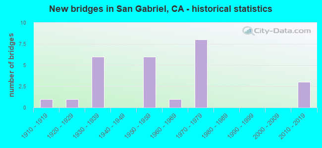
- New bridges - historical statistics
- 11910-1919
- 11920-1929
- 61930-1939
- 61950-1959
- 11960-1969
- 81970-1979
- 32010-2019
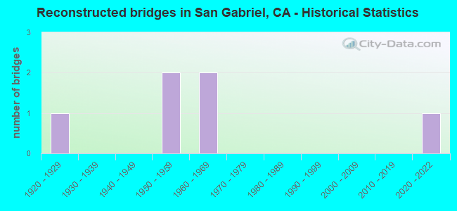
- Reconstructed bridges - Historical Statistics
- 11920-1929
- 01930-1939
- 01940-1949
- 21950-1959
- 21960-1969
- 01970-1979
- 01980-1989
- 01990-1999
- 02000-2009
- 02010-2019
- 12020-2022
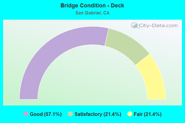
- Bridge Condition - Deck
- 57.1%Good
- 21.4%Satisfactory
- 21.4%Fair
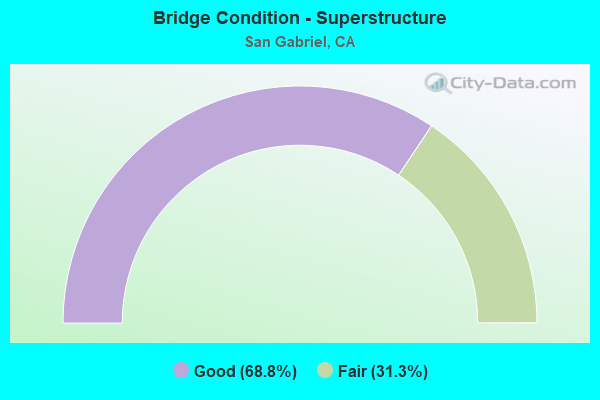
- Bridge Condition - Superstructure
- 68.8%Good
- 31.3%Fair
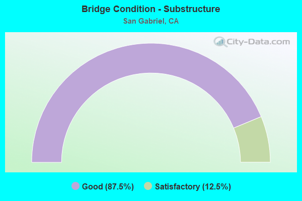
- Bridge Condition - Substructure
- 87.5%Good
- 12.5%Satisfactory
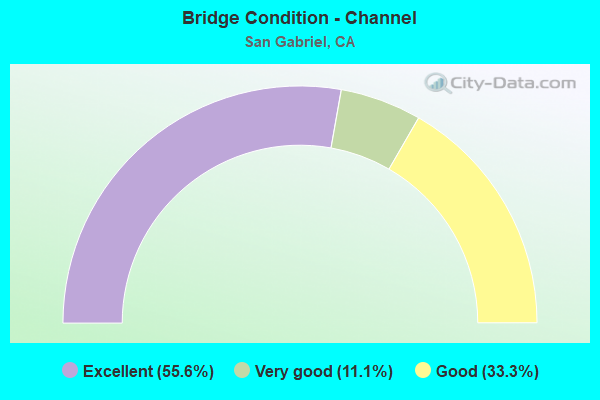
- Bridge Condition - Channel
- 55.6%Excellent
- 11.1%Very good
- 33.3%Good
Find on map >> Show street view
Structure Number: 53 0652L, Location: 07-LA-010-25.33-SGB (Lat: 34.071953, Lng: -118.099689), Route carried "on" structure: Interstate 10, Year Built: 1953, Year Reconstructed: 1972, Status: Open, Structure Length: 2.44m (8.01ft), Average Daily Traffic: 107,500 (year 2011), Truck Traffic: 6%, Average Future Daily Traffic: 134,550 (year 2043), Design Load: HS 20, Features Intersected: DEL MAR AVE
Minimum Vertical Clearance: 30+ m (98+ ft), Kilometerpoint: 25.330, Lanes on structure: 7, Lanes under structure: 4, Base Highway Network: Yes (, Subroute: 1), Owner: State Highway Agency, Approaching Roadway Width: 27.6m (90.6ft), Skew: 20 degrees, Material/Design: Concrete continuous, Design/Construction: Slab, Number Of Spans In Main Unit: 2, Length of Maximum Span: 24.1m (79.1ft), Curb-To-Curb Width: 27.6m (90.6ft), Out-to-Out Width: 37.2m (122.0ft)
Condition: Deck: Fair, Superstructure: Fair, Substructure: Good, Operating Rating: 66.2 metric tons, Method Used To Determine Operating Rating: Load Factor (LF), Inventory Rating: 32.6 metric tons, Method Used To Determine Inventory Rating: Load Factor (LF), Structural Evaluation: Somewhat better than minimum adequacy, Deck Geometry: Meets minimum limits, Underclear: Meets minimum limits, Approach Roadway Alignment: Equal to present desirable criteria, Designated Inspection Frequency: Every 24 months, Inspection Date: Febuary 2021, Deck Structure Type: Concrete Cast-file-Place
Find on map >> Show street view
Structure Number: 53 0652R, Location: 07-LA-010-25.33-SGB (Lat: 34.071692, Lng: -118.099686), Route carried "on" structure: Interstate 10, Year Built: 1953, Year Reconstructed: 1972, Status: Open, Structure Length: 2.44m (8.01ft), Average Daily Traffic: 107,500 (year 2011), Truck Traffic: 6%, Average Future Daily Traffic: 134,550 (year 2043), Design Load: HS 20, Features Intersected: DEL MAR AVE
Minimum Vertical Clearance: 30+ m (98+ ft), Kilometerpoint: 25.330, Lanes on structure: 6, Lanes under structure: 4, Base Highway Network: Yes (, Subroute: 1), Owner: State Highway Agency, Approaching Roadway Width: 23.1m (75.8ft), Material/Design: Concrete continuous, Design/Construction: Slab, Number Of Spans In Main Unit: 2, Length of Maximum Span: 24.1m (79.1ft), Curb or Sidewalk Widths: Left: 0.0m, Right: 0.6m (2.0ft), Curb-To-Curb Width: 23.1m (75.8ft), Out-to-Out Width: 23.9m (78.4ft)
Condition: Deck: Fair, Superstructure: Fair, Substructure: Good, Operating Rating: 63.5 metric tons, Method Used To Determine Operating Rating: Load Factor (LF), Inventory Rating: 32.6 metric tons, Method Used To Determine Inventory Rating: Load Factor (LF), Structural Evaluation: Somewhat better than minimum adequacy, Deck Geometry: High priority of replacement, Underclear: Meets minimum limits, Approach Roadway Alignment: Superior to present desirable criteria, Designated Inspection Frequency: Every 24 months, Inspection Date: Febuary 2021, Deck Structure Type: Concrete Cast-file-Place
Find on map >> Show street view
Structure Number: 53 0652S, Location: 07-LA-010-25.33-SGB (Lat: 34.071567, Lng: -118.099683), Route carried "on" structure: Ramp Interstate 10, Year Built: 1953, Status: Open, Structure Length: 2.41m (7.91ft), Average Daily Traffic: 7,700 (year 2011), Truck Traffic: 2%, Average Future Daily Traffic: 11,850 (year 2043), Design Load: HS 20, Features Intersected: DEL MAR AVE
Minimum Vertical Clearance: 30+ m (98+ ft), Kilometerpoint: 25.330, Lanes on structure: 2, Lanes under structure: 4, Owner: State Highway Agency, Approaching Roadway Width: 9.5m (31.2ft), Material/Design: Concrete continuous, Design/Construction: Slab, Number Of Spans In Main Unit: 2, Length of Maximum Span: 11.9m (39.0ft), Curb or Sidewalk Widths: Left: 0.6m (2.0ft), Right: 0.6m (2.0ft), Curb-To-Curb Width: 9.5m (31.2ft), Out-to-Out Width: 10.3m (33.8ft)
Condition: Deck: Fair, Superstructure: Fair, Substructure: Good, Operating Rating: 87.5 metric tons, Method Used To Determine Operating Rating: Load Factor (LF), Inventory Rating: 52.5 metric tons, Method Used To Determine Inventory Rating: Load Factor (LF), Structural Evaluation: Somewhat better than minimum adequacy, Deck Geometry: Somewhat better than minimum adequacy, Underclear: Meets minimum limits, Approach Roadway Alignment: Superior to present desirable criteria, Designated Inspection Frequency: Every 24 months, Inspection Date: Febuary 2021, Deck Structure Type: Concrete Cast-file-Place
Find on map >> Show street view
Structure Number: 53 2536K, Location: 07-LA-010S-25.14-SGB (Lat: 34.072014, Lng: -118.102847), Route carried "on" structure: Interstate 10, Year Built: 1972, Status: Open, Structure Length: 17.29m (56.73ft), Average Daily Traffic: 500 (year 2012), Truck Traffic: 2%, Average Future Daily Traffic: 618 (year 2040), Design Load: HS 20+Mod, Features Intersected: I 10&HOV WB, SCRRA, BNSF
Minimum Vertical Clearance: 30+ m (98+ ft), Kilometerpoint: 25.140, Lanes on structure: 1, Lanes under structure: 7, Toll: On toll road, Owner: State Highway Agency, Approaching Roadway Width: 7.3m (24.0ft), Skew: 9 degrees, Material/Design: Prestressed concrete continuous, Design/Construction: Box Beam or Girders - Multiple, Number Of Spans In Main Unit: 4, Length of Maximum Span: 57.4m (188.3ft), Curb-To-Curb Width: 7.3m (24.0ft), Out-to-Out Width: 8.2m (26.9ft)
Condition: Deck: Good, Superstructure: Fair, Substructure: Good, Operating Rating: 99.8 metric tons, Method Used To Determine Operating Rating: Load Factor (LF), Inventory Rating: 32.4 metric tons, Method Used To Determine Inventory Rating: Load Factor (LF), Structural Evaluation: Somewhat better than minimum adequacy, Deck Geometry: Meets minimum limits, Underclear: High priority of corrective action, Approach Roadway Alignment: Equal to present desirable criteria, Designated Inspection Frequency: Every 24 months, Inspection Date: October 2021, Deck Structure Type: Concrete Cast-file-Place
Find on map >> Show street view
Structure Number: 53 2536S, Location: 07-LA-010S-25.14-SGB (Lat: 34.071878, Lng: -118.102853), Route carried "on" structure: Ramp Interstate 10, Year Built: 1972, Status: Open, Structure Length: 18.98m (62.27ft), Average Daily Traffic: 500 (year 2012), Truck Traffic: 2%, Average Future Daily Traffic: 618 (year 2040), Design Load: HS 20+Mod, Features Intersected: I 10&HOV WB, SCRRA, BNSF
Minimum Vertical Clearance: 30+ m (98+ ft), Kilometerpoint: 25.140, Lanes on structure: 1, Lanes under structure: 6, Toll: On toll road, Owner: State Highway Agency, Approaching Roadway Width: 7.3m (24.0ft), Skew: 9 degrees, Material/Design: Prestressed concrete continuous, Design/Construction: Box Beam or Girders - Multiple, Number Of Spans In Main Unit: 4, Length of Maximum Span: 57.0m (187.0ft), Curb-To-Curb Width: 7.3m (24.0ft), Out-to-Out Width: 8.2m (26.9ft)
Condition: Deck: Good, Superstructure: Fair, Substructure: Good, Operating Rating: 99.8 metric tons, Method Used To Determine Operating Rating: Load Factor (LF), Inventory Rating: 32.4 metric tons, Method Used To Determine Inventory Rating: Load Factor (LF), Structural Evaluation: Somewhat better than minimum adequacy, Deck Geometry: Better than present minimum criteria, Underclear: High priority of corrective action, Approach Roadway Alignment: Equal to present desirable criteria, Designated Inspection Frequency: Every 24 months, Inspection Date: October 2021, Deck Structure Type: Concrete Cast-file-Place
Find on map >> Show street view
Structure Number: 53C0345, Location: 0.5MI W/O SAN GABRIEL B (Lat: 34.079528, Lng: -118.101481), Route carried "on" structure: City street L353, Year Built: 1931, Status: Open, Structure Length: 1.19m (3.90ft), Average Daily Traffic: 30,952 (year 2012), Truck Traffic: 2%, Average Future Daily Traffic: 37,142 (year 2040), Features Intersected: ALHAMBRA WASH, Facility Carried by Structure: VALLEY BLVD
Minimum Vertical Clearance: 30.47m (99.97ft), Kilometerpoint: 0.000, Lanes on structure: 4, Owner: City or Municipal Highway Agency, Approaching Roadway Width: 23.2m (76.1ft), Skew: 33 degrees, Material/Design: Concrete, Design/Construction: Arch - Deck, Number Of Spans In Main Unit: 1, Length of Maximum Span: 9.8m (32.2ft), Curb or Sidewalk Widths: Left: 2.7m (8.9ft), Right: 2.7m (8.9ft), Curb-To-Curb Width: 23.2m (76.1ft), Out-to-Out Width: 30.0m (98.4ft)
Condition: Superstructure: Good, Substructure: Good, Channel: Excellent, Operating Rating: 61.2 metric tons, Method Used To Determine Operating Rating: Load Factor (LF), Inventory Rating: 36.6 metric tons, Method Used To Determine Inventory Rating: Load Factor (LF), Structural Evaluation: Better than present minimum criteria, Deck Geometry: Superior to present desirable criteria, Waterway Adequacy: Superior to present desirable criteria, Approach Roadway Alignment: Equal to present desirable criteria, Designated Inspection Frequency: Every 48 months, Inspection Date: November 2020
Find on map >> Show street view
Structure Number: 53C0909, Location: 0.1MI W/O SAN GABRIEL BL (Lat: 34.103314, Lng: -118.093011), Route carried "on" structure: City street L496, Year Built: 1911, Year Reconstructed: 1932, Status: Open, Structure Length: 1.37m (4.49ft), Average Daily Traffic: 30,846 (year 2012), Truck Traffic: 1%, Average Future Daily Traffic: 37,015 (year 2040), Features Intersected: RUBIO WASH, Facility Carried by Structure: E LAS TUNAS DR
Minimum Vertical Clearance: 30.47m (99.97ft), Kilometerpoint: 0.000, Lanes on structure: 4, Owner: City or Municipal Highway Agency, Approaching Roadway Width: 21.9m (71.9ft), Skew: 1 degrees, Material/Design: Concrete continuous, Design/Construction: Tee Beam, Number Of Spans In Main Unit: 2, Length of Maximum Span: 6.7m (22.0ft), Curb or Sidewalk Widths: Left: 4.0m (13.1ft), Right: 4.6m (15.1ft), Curb-To-Curb Width: 21.9m (71.9ft), Out-to-Out Width: 30.9m (101.4ft)
Condition: Deck: Good, Superstructure: Good, Substructure: Good, Channel: Excellent, Operating Rating: 28.5 metric tons, Method Used To Determine Operating Rating: Field evaluation and documented engineering judgment, Inventory Rating: 17.2 metric tons, Method Used To Determine Inventory Rating: Field evaluation and documented engineering judgment, Structural Evaluation: Meets minimum limits, Deck Geometry: Superior to present desirable criteria, Waterway Adequacy: Equal to present minimum criteria, Approach Roadway Alignment: Equal to present desirable criteria, Designated Inspection Frequency: Every 24 months, Inspection Date: November 2020, Deck Structure Type: Concrete Cast-file-Place, Wearing Surface/Protective System: Wearing Surface: Bituminous
Find on map >> Show street view
Structure Number: 53C0983, Location: 0.5MI W/O SAN GABRIEL BL (Lat: 34.075281, Lng: -118.098875), Route carried "on" structure: City street QS42, Year Built: 1936, Year Reconstructed: 1963, Status: Open, Structure Length: 1.40m (4.59ft), Average Daily Traffic: 2,754 (year 2012), Truck Traffic: 1%, Average Future Daily Traffic: 3,029 (year 2040), Design Load: HS 20, Features Intersected: ALHAMBRA WASH, Facility Carried by Structure: MARSHALL ST
Minimum Vertical Clearance: 30.47m (99.97ft), Kilometerpoint: 0.000, Lanes on structure: 2, Owner: City or Municipal Highway Agency, Approaching Roadway Width: 10.7m (35.1ft), Skew: 1 degrees, Material/Design: Steel, Design/Construction: Stringer/Multi-beam, Number Of Spans In Main Unit: 1, Length of Maximum Span: 13.1m (43.0ft), Curb or Sidewalk Widths: Left: 1.4m (4.6ft), Right: 1.4m (4.6ft), Curb-To-Curb Width: 12.2m (40.0ft), Out-to-Out Width: 15.7m (51.5ft)
Condition: Deck: Satisfactory, Superstructure: Good, Substructure: Good, Channel: Excellent, Operating Rating: 56.1 metric tons, Method Used To Determine Operating Rating: Load Factor (LF), Inventory Rating: 33.4 metric tons, Method Used To Determine Inventory Rating: Load Factor (LF), Structural Evaluation: Better than present minimum criteria, Deck Geometry: Equal to present minimum criteria, Waterway Adequacy: Superior to present desirable criteria, Approach Roadway Alignment: Equal to present desirable criteria, Designated Inspection Frequency: Every 48 months, Inspection Date: November 2020, Deck Structure Type: Concrete Cast-file-Place, Wearing Surface/Protective System: Wearing Surface: Bituminous
Find on map >> Show street view
Structure Number: 53C0984, Location: 0.5MI W/O SAN GABRIEL BL (Lat: 34.072944, Lng: -118.097561), Route carried "on" structure: City street , Year Built: 1936, Year Reconstructed: 1963, Status: Open, Structure Length: 1.62m (5.31ft), Average Daily Traffic: 1,326 (year 2012), Truck Traffic: 1%, Average Future Daily Traffic: 1,459 (year 2040), Features Intersected: ALHAMBRA WASH, Facility Carried by Structure: SAXON AVE
Minimum Vertical Clearance: 30.47m (99.97ft), Kilometerpoint: 0.000, Lanes on structure: 2, Owner: City or Municipal Highway Agency, Approaching Roadway Width: 11.0m (36.1ft), Skew: 3 degrees, Material/Design: Steel, Design/Construction: Stringer/Multi-beam, Number Of Spans In Main Unit: 1, Length of Maximum Span: 14.9m (48.9ft), Curb or Sidewalk Widths: Left: 1.4m (4.6ft), Right: 0.5m (1.6ft), Curb-To-Curb Width: 12.1m (39.7ft), Out-to-Out Width: 14.6m (47.9ft)
Condition: Deck: Satisfactory, Superstructure: Good, Substructure: Good, Channel: Excellent, Operating Rating: 49.6 metric tons, Method Used To Determine Operating Rating: Load Factor (LF), Inventory Rating: 29.8 metric tons, Method Used To Determine Inventory Rating: Load Factor (LF), Structural Evaluation: Better than present minimum criteria, Deck Geometry: Equal to present minimum criteria, Waterway Adequacy: Superior to present desirable criteria, Approach Roadway Alignment: Equal to present desirable criteria, Designated Inspection Frequency: Every 24 months, Other Special Inspection Frequency: Every 48 months, Inspection Date: November 2020, Other Special Inspection Date: June 2019, Deck Structure Type: Concrete Cast-file-Place, Wearing Surface/Protective System: Wearing Surface: Monolithic Concrete
Find on map >> Show street view
Structure Number: 53C1031, Location: 0.1MI W/O SAN GABRIEL BL (Lat: 34.106175, Lng: -118.093683), Route carried "on" structure: City street QS10, Year Built: 1927, Status: Open, Structure Length: 1.01m (3.31ft), Average Daily Traffic: 4,794 (year 2012), Truck Traffic: 1%, Average Future Daily Traffic: 5,273 (year 2040), Features Intersected: RUBIO WASH, Facility Carried by Structure: HERMOSA DR
Minimum Vertical Clearance: 30.47m (99.97ft), Kilometerpoint: 0.000, Lanes on structure: 2, Owner: City or Municipal Highway Agency, Approaching Roadway Width: 12.2m (40.0ft), Skew: 1 degrees, Material/Design: Concrete, Design/Construction: Tee Beam, Number Of Spans In Main Unit: 1, Length of Maximum Span: 9.1m (29.9ft), Curb or Sidewalk Widths: Left: 1.8m (5.9ft), Right: 1.8m (5.9ft), Curb-To-Curb Width: 12.2m (40.0ft), Out-to-Out Width: 16.4m (53.8ft)
Condition: Deck: Satisfactory, Superstructure: Good, Substructure: Satisfactory, Channel: Good, Operating Rating: 58.3 metric tons, Method Used To Determine Operating Rating: Load Factor (LF), Inventory Rating: 35.0 metric tons, Method Used To Determine Inventory Rating: Load Factor (LF), Structural Evaluation: Equal to present minimum criteria, Deck Geometry: Equal to present minimum criteria, Waterway Adequacy: Equal to present desirable criteria, Approach Roadway Alignment: Equal to present desirable criteria, Designated Inspection Frequency: Every 48 months, Inspection Date: October 2020, Deck Structure Type: Concrete Cast-file-Place, Wearing Surface/Protective System: Wearing Surface: Monolithic Concrete
Find on map >> Show street view
Structure Number: 53C1032, Location: 0.4MI W/O SAN GABRIEL BL (Lat: 34.113406, Lng: -118.097736), Route carried "on" structure: City street Q497, Year Built: 1962, Status: Open, Structure Length: 1.04m (3.41ft), Average Daily Traffic: 4,386 (year 2012), Truck Traffic: 1%, Average Future Daily Traffic: 4,825 (year 2040), Features Intersected: RUBIO WASH, Facility Carried by Structure: LONGDEN DR
Minimum Vertical Clearance: 30.47m (99.97ft), Kilometerpoint: 0.000, Lanes on structure: 2, Owner: City or Municipal Highway Agency, Approaching Roadway Width: 9.8m (32.2ft), Material/Design: Concrete, Design/Construction: Arch - Deck, Number Of Spans In Main Unit: 1, Length of Maximum Span: 9.1m (29.9ft), Curb or Sidewalk Widths: Left: 0.5m (1.6ft), Right: 0.2m (0.7ft), Curb-To-Curb Width: 10.2m (33.5ft), Out-to-Out Width: 13.7m (44.9ft)
Condition: Superstructure: Good, Substructure: Good, Channel: Very good, Operating Rating: 54.1 metric tons, Method Used To Determine Operating Rating: Load Factor (LF), Inventory Rating: 32.4 metric tons, Method Used To Determine Inventory Rating: Load Factor (LF), Structural Evaluation: Better than present minimum criteria, Deck Geometry: Meets minimum limits, Waterway Adequacy: Equal to present desirable criteria, Approach Roadway Alignment: Equal to present desirable criteria, Designated Inspection Frequency: Every 48 months, Inspection Date: October 2020
Find on map >> Show street view
Structure Number: 53C1582, Location: 400FT E/O SAN GAB BLVD (Lat: 34.098922, Lng: -118.090072), Route carried "on" structure: City street Q986, Year Built: 1935, Status: Open, Structure Length: 0.88m (2.89ft), Average Daily Traffic: 10,300 (year 2012), Truck Traffic: 1%, Average Future Daily Traffic: 11,845 (year 2040), Features Intersected: RUBIO WASH, Facility Carried by Structure: BROADWAY
Minimum Vertical Clearance: 30.47m (99.97ft), Kilometerpoint: 0.000, Lanes on structure: 2, Owner: City or Municipal Highway Agency, Approaching Roadway Width: 12.8m (42.0ft), Skew: 1 degrees, Material/Design: Concrete, Design/Construction: Culvert, Number Of Spans In Main Unit: 2, Length of Maximum Span: 4.0m (13.1ft), Curb or Sidewalk Widths: Left: 0.2m (0.7ft), Right: 2.9m (9.5ft), Curb-To-Curb Width: 12.6m (41.3ft), Out-to-Out Width: 19.1m (62.7ft)
Condition: Channel: Good, Culverts: Very good, Operating Rating: 67.4 metric tons, Method Used To Determine Operating Rating: Load Factor (LF), Inventory Rating: 40.2 metric tons, Method Used To Determine Inventory Rating: Load Factor (LF), Structural Evaluation: Equal to present desirable criteria, Deck Geometry: Somewhat better than minimum adequacy, Waterway Adequacy: Better than present minimum criteria, Approach Roadway Alignment: Equal to present desirable criteria, Designated Inspection Frequency: Every 48 months, Inspection Date: November 2020
Find on map >> Show street view
Structure Number: 53C1583, Location: 0.3MI N/O VALLEY BLVD (Lat: 34.084453, Lng: -118.107914), Route carried "on" structure: City street L362, Year Built: 1937, Status: Open, Structure Length: 1.40m (4.59ft), Average Daily Traffic: 18,656 (year 2012), Truck Traffic: 1%, Average Future Daily Traffic: 22,387 (year 2040), Features Intersected: ALHAMBRA WASH, Facility Carried by Structure: RAMONA ST
Minimum Vertical Clearance: 30.47m (99.97ft), Kilometerpoint: 0.000, Lanes on structure: 3, Owner: City or Municipal Highway Agency, Approaching Roadway Width: 12.2m (40.0ft), Skew: 2 degrees, Material/Design: Concrete continuous, Design/Construction: Slab, Number Of Spans In Main Unit: 2, Length of Maximum Span: 6.7m (22.0ft), Curb or Sidewalk Widths: Left: 2.7m (8.9ft), Right: 2.7m (8.9ft), Curb-To-Curb Width: 12.2m (40.0ft), Out-to-Out Width: 18.3m (60.0ft)
Condition: Deck: Good, Superstructure: Good, Substructure: Satisfactory, Channel: Good, Operating Rating: 50.5 metric tons, Method Used To Determine Operating Rating: Load Factor (LF), Inventory Rating: 30.5 metric tons, Method Used To Determine Inventory Rating: Load Factor (LF), Structural Evaluation: Equal to present minimum criteria, Deck Geometry: Meets minimum limits, Waterway Adequacy: Better than present minimum criteria, Approach Roadway Alignment: Equal to present minimum criteria, Designated Inspection Frequency: Every 24 months, Inspection Date: November 2020, Deck Structure Type: Concrete Cast-file-Place, Wearing Surface/Protective System: Wearing Surface: Bituminous
Find on map >> Show street view
Structure Number: 53C2352, Location: 1.1 MILE N/O VALLEY BLVD (Lat: 34.096389, Lng: -118.105556), Route carried "on" structure: City street L354, Year Built: 2016, Status: Open, Structure Length: 2.01m (6.59ft), Average Daily Traffic: 22,260 (year 2012), Truck Traffic: 1%, Average Future Daily Traffic: 26,712 (year 2041), Design Load: HL 93, Features Intersected: UPRR, Facility Carried by Structure: Mission Road
Minimum Vertical Clearance: 30.47m (99.97ft), Kilometerpoint: 1.999, Lanes on structure: 4, Owner: City or Municipal Highway Agency, Approaching Roadway Width: 24.0m (78.7ft), Skew: 1 degrees, Material/Design: Concrete, Design/Construction: Stringer/Multi-beam, Number Of Spans In Main Unit: 1, Length of Maximum Span: 20.0m (65.6ft), Curb or Sidewalk Widths: Left: 3.6m (11.8ft), Right: 3.6m (11.8ft), Curb-To-Curb Width: 23.4m (76.8ft), Out-to-Out Width: 33.5m (109.9ft)
Condition: Deck: Good, Superstructure: Good, Substructure: Good, Operating Rating: 42.1 metric tons, Method Used To Determine Operating Rating: Assigned ratings based on Load and Resistance Factor Design (LRFD) reported by rating factor (RF) using HL93 loadings, Inventory Rating: 32.4 metric tons, Method Used To Determine Inventory Rating: Assigned ratings based on Load and Resistance Factor Design (LRFD) reported by rating factor (RF) using HL93 loadings, Structural Evaluation: Better than present minimum criteria, Deck Geometry: Better than present minimum criteria, Approach Roadway Alignment: Better than present minimum criteria, Designated Inspection Frequency: Every 48 months, Inspection Date: June 2021, Deck Structure Type: Concrete Cast-file-Place, Wearing Surface/Protective System: Wearing Surface: Monolithic Concrete
Find on map >> Show street view
Structure Number: 53C2353, Location: 1.2 M. N/O VALLEY (Lat: 34.097778, Lng: -118.100000), Route carried "on" structure: City street Q491, Year Built: 2016, Status: Open, Structure Length: 1.90m (6.23ft), Average Daily Traffic: 24,380 (year 2012), Truck Traffic: 1%, Average Future Daily Traffic: 29,256 (year 2041), Design Load: HL 93, Features Intersected: UPRR, Facility Carried by Structure: Del Mar Ave.
Minimum Vertical Clearance: 30.47m (99.97ft), Kilometerpoint: 0.000, Lanes on structure: 2, Owner: City or Municipal Highway Agency, Approaching Roadway Width: 16.9m (55.4ft), Material/Design: Concrete, Design/Construction: Stringer/Multi-beam, Number Of Spans In Main Unit: 1, Length of Maximum Span: 18.7m (61.4ft), Curb or Sidewalk Widths: Left: 3.2m (10.5ft), Right: 3.2m (10.5ft), Curb-To-Curb Width: 17.0m (55.8ft), Out-to-Out Width: 22.9m (75.1ft)
Condition: Deck: Good, Superstructure: Good, Substructure: Good, Operating Rating: 42.1 metric tons, Method Used To Determine Operating Rating: Assigned ratings based on Load and Resistance Factor Design (LRFD) reported by rating factor (RF) using HL93 loadings, Inventory Rating: 32.4 metric tons, Method Used To Determine Inventory Rating: Assigned ratings based on Load and Resistance Factor Design (LRFD) reported by rating factor (RF) using HL93 loadings, Structural Evaluation: Better than present minimum criteria, Deck Geometry: Superior to present desirable criteria, Underclear: Meets minimum limits, Approach Roadway Alignment: Better than present minimum criteria, Designated Inspection Frequency: Every 48 months, Inspection Date: June 2021, Deck Structure Type: Concrete Cast-file-Place, Wearing Surface/Protective System: Wearing Surface: Monolithic Concrete
Find on map >> Show street view
Structure Number: 53C2354, Location: 1.1 MILE N/OVALLEY BLVD (Lat: 34.096306, Lng: -118.090972), Route carried "on" structure: City street L364, Year Built: 2016, Status: Open, Structure Length: 2.20m (7.22ft), Average Daily Traffic: 32,542 (year 2012), Truck Traffic: 2%, Average Future Daily Traffic: 39,050 (year 2041), Design Load: HL 93, Features Intersected: UPRR, Facility Carried by Structure: San Gabriel Blvd
Minimum Vertical Clearance: 30.47m (99.97ft), Kilometerpoint: 0.000, Lanes on structure: 4, Owner: City or Municipal Highway Agency, Approaching Roadway Width: 19.2m (63.0ft), Skew: 30 degrees, Material/Design: Concrete, Design/Construction: Stringer/Multi-beam, Number Of Spans In Main Unit: 1, Length of Maximum Span: 21.0m (68.9ft), Curb or Sidewalk Widths: Left: 3.6m (11.8ft), Right: 3.6m (11.8ft), Curb-To-Curb Width: 22.8m (74.8ft), Out-to-Out Width: 31.6m (103.7ft)
Condition: Deck: Good, Superstructure: Good, Substructure: Good, Operating Rating: 42.1 metric tons, Method Used To Determine Operating Rating: Assigned ratings based on Load and Resistance Factor Design (LRFD) reported by rating factor (RF) using HL93 loadings, Inventory Rating: 32.4 metric tons, Method Used To Determine Inventory Rating: Assigned ratings based on Load and Resistance Factor Design (LRFD) reported by rating factor (RF) using HL93 loadings, Structural Evaluation: Better than present minimum criteria, Deck Geometry: Superior to present desirable criteria, Underclear: Somewhat better than minimum adequacy, Approach Roadway Alignment: Better than present minimum criteria, Designated Inspection Frequency: Every 48 months, Inspection Date: June 2021, Deck Structure Type: Concrete Cast-file-Place, Wearing Surface/Protective System: Wearing Surface: Monolithic Concrete
Find on map >> Show street view
Structure Number: 53C2379, Location: 0.2MI S/O VALLEY BLVD (Lat: 34.077306, Lng: -118.099611), Route carried "on" structure: City street Q491, Year Built: 1935, Year Reconstructed: 2020, Status: Open, Structure Length: 2.37m (7.78ft), Average Daily Traffic: 24,380 (year 2012), Truck Traffic: 1%, Average Future Daily Traffic: 29,256 (year 2041), Design Load: HL 93, Features Intersected: ALHAMBRA WASH, Facility Carried by Structure: DEL MAR AVE
Minimum Vertical Clearance: 30.48m (100.00ft), Kilometerpoint: 0.000, Lanes on structure: 4, Owner: City or Municipal Highway Agency, Approaching Roadway Width: 19.5m (64.0ft), Skew: 5 degrees, Material/Design: Prestressed concrete, Design/Construction: Girder and Floorbeam System, Number Of Spans In Main Unit: 1, Length of Maximum Span: 22.9m (75.1ft), Curb or Sidewalk Widths: Left: 1.8m (5.9ft), Right: 1.8m (5.9ft), Curb-To-Curb Width: 19.5m (64.0ft), Out-to-Out Width: 22.0m (72.2ft)
Condition: Deck: Good, Superstructure: Good, Substructure: Good, Channel: Excellent, Operating Rating: 42.1 metric tons, Method Used To Determine Operating Rating: Assigned ratings based on Load and Resistance Factor Design (LRFD) reported by rating factor (RF) using HL93 loadings, Inventory Rating: 32.4 metric tons, Method Used To Determine Inventory Rating: Assigned ratings based on Load and Resistance Factor Design (LRFD) reported by rating factor (RF) using HL93 loadings, Structural Evaluation: Better than present minimum criteria, Deck Geometry: Better than present minimum criteria, Waterway Adequacy: Superior to present desirable criteria, Approach Roadway Alignment: Equal to present desirable criteria, Designated Inspection Frequency: Every 24 months, Inspection Date: April 2021, Deck Structure Type: Concrete Cast-file-Place
Find on map >> Show street view
Structure Number: 53 0652L, Location: 07-LA-010-25.33-SGB (Lat: 34.071953, Lng: -118.099689), Route carried "under" structure: City street , Year Built: 1953, Structure Length: 0. m, Average Daily Traffic: 16,000 (year 2011), Truck Traffic: 2%, Features Intersected: DEL MAR AVE, Facility Carried by Structure: INTERSTATE 10 WB
Minimum Vertical Clearance: 4.60m (15.09ft), Kilometerpoint: 0.000, Lanes on structure: 7, Lanes under structure: 4, Material/Design: Concrete continuous, Design/Construction: Slab, Length of Maximum Span: 24.1m (79.1ft)
Find on map >> Show street view
Structure Number: 53 0652R, Location: 07-LA-010-25.33-SGB (Lat: 34.071692, Lng: -118.099686), Route carried "under" structure: City street , Year Built: 1953, Structure Length: 0. m, Average Daily Traffic: 22,000 (year 2011), Truck Traffic: 2%, Features Intersected: DEL MAR AVE, Facility Carried by Structure: INTERSTATE 10 EB
Minimum Vertical Clearance: 5.36m (17.59ft), Kilometerpoint: 0.000, Lanes on structure: 6, Lanes under structure: 4, Material/Design: Concrete continuous, Design/Construction: Slab, Length of Maximum Span: 24.1m (79.1ft)
Find on map >> Show street view
Structure Number: 53 0652S, Location: 07-LA-010-25.33-SGB (Lat: 34.071567, Lng: -118.099683), Route carried "under" structure: City street , Year Built: 1953, Structure Length: 0. m, Average Daily Traffic: 22,000 (year 2011), Truck Traffic: 2%, Features Intersected: DEL MAR AVE, Facility Carried by Structure: E10-DEL MAR
Minimum Vertical Clearance: 4.65m (15.26ft), Kilometerpoint: 0.000, Lanes on structure: 2, Lanes under structure: 4, Material/Design: Concrete continuous, Design/Construction: Slab, Length of Maximum Span: 11.9m (39.0ft)
Find on map >> Show street view
Structure Number: 53 2535, Location: 07-LA-010-25.10-SGB (Lat: 34.072417, Lng: -118.103969), Route carried "under" structure: Interstate 10, Year Built: 1972, Structure Length: 0. m, Average Daily Traffic: 215,000 (year 2011), Truck Traffic: 6%, Features Intersected: I 10, HOV, SCRRA, BNSF, Facility Carried by Structure: PEDESTRIAN WALKWAY
Minimum Vertical Clearance: 5.86m (19.23ft), Kilometerpoint: 25.100, Lanes under structure: 11, Material/Design: Prestressed concrete, Design/Construction: Box Beam or Girders - Multiple, Length of Maximum Span: 42.1m (138.1ft)
Find on map >> Show street view
Structure Number: 53 2536K, Location: 07-LA-010S-25.14-SGB (Lat: 34.072014, Lng: -118.102847), Route carried "under" structure: Interstate 10, Year Built: 1972, Structure Length: 0. m, Average Daily Traffic: 215,000 (year 2012), Truck Traffic: 6%, Features Intersected: I 10&HOV WB, SCRRA, BNSF
Minimum Vertical Clearance: 6.78m (22.24ft), Kilometerpoint: 25.140, Lanes on structure: 1, Lanes under structure: 6, Material/Design: Prestressed concrete continuous, Design/Construction: Box Beam or Girders - Multiple, Length of Maximum Span: 57.4m (188.3ft)
Find on map >> Show street view
Structure Number: 53 2536K, Location: 07-LA-010S-25.14-SGB (Lat: 34.072014, Lng: -118.102847), Route carried "under" structure: Interstate 10, Year Built: 1972, Structure Length: 0. m, Average Daily Traffic: 3,500 (year 2011), Truck Traffic: 5%, Features Intersected: I 10&HOV WB, SCRRA, BNSF
Minimum Vertical Clearance: 6.34m (20.80ft), Kilometerpoint: 25.140, Lanes on structure: 1, Lanes under structure: 1, Material/Design: Prestressed concrete continuous, Design/Construction: Box Beam or Girders - Multiple, Length of Maximum Span: 57.4m (188.3ft)
Find on map >> Show street view
Structure Number: 53 2536S, Location: 07-LA-010S-25.14-SGB (Lat: 34.071878, Lng: -118.102853), Route carried "under" structure: Interstate 10, Year Built: 1972, Structure Length: 0. m, Average Daily Traffic: 120,000 (year 2012), Truck Traffic: 2%, Features Intersected: I 10&HOV WB, SCRRA, BNSF
Minimum Vertical Clearance: 6.98m (22.90ft), Kilometerpoint: 25.100, Lanes on structure: 1, Lanes under structure: 4, Material/Design: Prestressed concrete continuous, Design/Construction: Box Beam or Girders - Multiple, Length of Maximum Span: 57.0m (187.0ft)
Find on map >> Show street view
Structure Number: 53 2536S, Location: 07-LA-010S-25.14-SGB (Lat: 34.071878, Lng: -118.102853), Route carried "under" structure: Interstate 10, Year Built: 1972, Structure Length: 0. m, Average Daily Traffic: 3,000 (year 2012), Truck Traffic: 2%, Features Intersected: I 10&HOV WB, SCRRA, BNSF
Minimum Vertical Clearance: 7.60m (24.93ft), Kilometerpoint: 25.140, Lanes on structure: 1, Lanes under structure: 1, Material/Design: Prestressed concrete continuous, Design/Construction: Box Beam or Girders - Multiple, Length of Maximum Span: 57.0m (187.0ft)
Find on map >> Show street view
Structure Number: 53 2536S, Location: 07-LA-010S-25.14-SGB (Lat: 34.071878, Lng: -118.102853), Route carried "under" structure: Ramp State highway 10, Year Built: 1972, Structure Length: 0. m, Average Daily Traffic: 3,000 (year 2012), Truck Traffic: 2%, Features Intersected: I 10&HOV WB, SCRRA, BNSF
Minimum Vertical Clearance: 5.96m (19.55ft), Kilometerpoint: 25.140, Lanes on structure: 1, Lanes under structure: 1, Material/Design: Prestressed concrete continuous, Design/Construction: Box Beam or Girders - Multiple, Length of Maximum Span: 57.0m (187.0ft)