Bridge Statistics for San Clemente, California (CA)
Condition, Traffic, Stress, Structural Evaluation, Project Costs
- National Bridge Inventory (NBI) Statistics
- 37Number of bridges
- 482ft / 147mTotal length
- $121,000Total costs
- 2,803,805Total average daily traffic
- 185,202Total average daily truck traffic
- National Bridge Inventory (NBI) Registered Bridges for San Clemente
- No street view available for this location
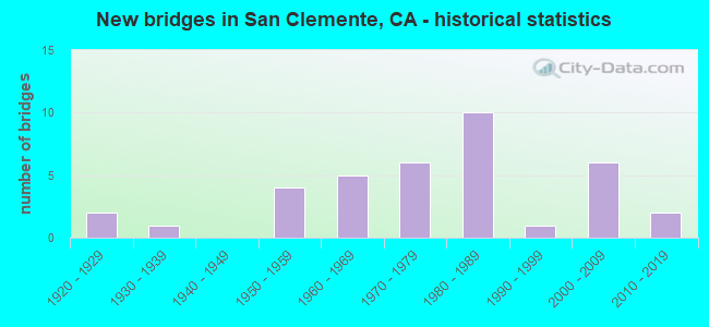
- New bridges - historical statistics
- 21920-1929
- 11930-1939
- 41950-1959
- 51960-1969
- 61970-1979
- 101980-1989
- 11990-1999
- 62000-2009
- 22010-2019
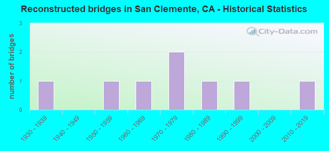
- Reconstructed bridges - Historical Statistics
- 11930-1939
- 01940-1949
- 11950-1959
- 11960-1969
- 21970-1979
- 11980-1989
- 11990-1999
- 02000-2009
- 12010-2019
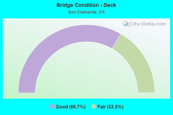
- Bridge Condition - Deck
- 66.7%Good
- 33.3%Fair
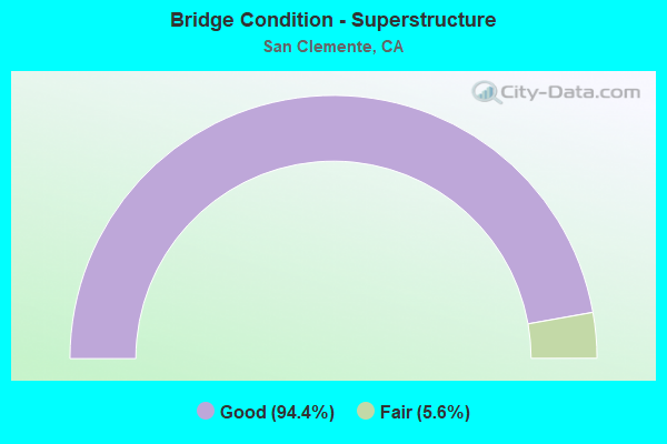
- Bridge Condition - Superstructure
- 94.4%Good
- 5.6%Fair
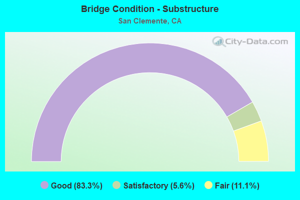
- Bridge Condition - Substructure
- 83.3%Good
- 5.6%Satisfactory
- 11.1%Fair
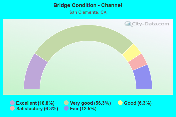
- Bridge Condition - Channel
- 18.8%Excellent
- 56.3%Very good
- 6.3%Good
- 6.3%Satisfactory
- 12.5%Fair
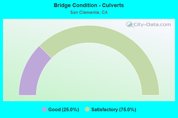
- Bridge Condition - Culverts
- 25.0%Good
- 75.0%Satisfactory
Find on map >> Show street view
Structure Number: 2CA0004, Location: SAN MATEO ROAD OVER SAN M (Lat: 33.419278, Lng: -117.536917), Route carried "on" structure: Federal lands road , Year Built: 1970, Status: Posted for load-capacity, Structure Length: 3.81m (12.50ft), Average Daily Traffic: 4,300 (year 2004), Truck Traffic: 1%, Average Future Daily Traffic: 5,160 (year 2040), Features Intersected: SAN MATEO CREEK, Facility Carried by Structure: SAN MATEO ROAD
Minimum Vertical Clearance: 30+ m (98+ ft), Kilometerpoint: 0.000, Lanes on structure: 2, Owner: Navy/Marines, Approaching Roadway Width: 7.9m (25.9ft), Skew: 4 degrees, Material/Design: Concrete continuous, Design/Construction: Slab, Number Of Spans In Main Unit: 5, Length of Maximum Span: 7.6m (24.9ft), Curb-To-Curb Width: 7.9m (25.9ft), Out-to-Out Width: 10.0m (32.8ft)
Condition: Deck: Good, Superstructure: Good, Substructure: Satisfactory, Channel: Fair, Operating Rating: 36.2 metric tons, Method Used To Determine Operating Rating: Field evaluation and documented engineering judgment, Inventory Rating: 32.6 metric tons, Method Used To Determine Inventory Rating: Field evaluation and documented engineering judgment, Structural Evaluation: Equal to present minimum criteria, Deck Geometry: High priority of corrective action, Waterway Adequacy: Equal to present desirable criteria, Approach Roadway Alignment: Equal to present minimum criteria, Length Of Structure Improvement: 3.81m (12.50ft), Designated Inspection Frequency: Every 24 months, Inspection Date: September 2020, Bridge Improvement Cost: $13,000, Roadway Improvement Cost: $62,000, Total Project Cost: $75,000 ( Estimate for 2020), Deck Structure Type: Concrete Cast-file-Place, Wearing Surface/Protective System: Wearing Surface: Monolithic Concrete
Find on map >> Show street view
Structure Number: 2CA0014, Location: AT SAN MATEO GATE (Lat: 33.427361, Lng: -117.569883), Route carried "on" structure: Bypass Federal lands road , Year Built: 2000, Status: Open, Structure Length: 1.14m (3.74ft), Average Daily Traffic: 5 (year 2014), Truck Traffic: 1%, Average Future Daily Traffic: 5,000 (year 2040), Features Intersected: CHRISTIANITOS CREEK, Facility Carried by Structure: SAN MATEO GATE BYP
Minimum Vertical Clearance: 30+ m (98+ ft), Kilometerpoint: 0.000, Lanes on structure: 2, Owner: Navy/Marines, Approaching Roadway Width: 10.7m (35.1ft), Material/Design: Concrete, Design/Construction: Culvert, Number Of Spans In Main Unit: 3, Length of Maximum Span: 3.7m (12.1ft), Curb-To-Curb Width: 10.1m (33.1ft), Out-to-Out Width: 11.3m (37.1ft)
Condition: Channel: Satisfactory, Culverts: Good, Operating Rating: 36.2 metric tons, Method Used To Determine Operating Rating: Field evaluation and documented engineering judgment, Inventory Rating: 32.6 metric tons, Method Used To Determine Inventory Rating: Field evaluation and documented engineering judgment, Structural Evaluation: Better than present minimum criteria, Deck Geometry: Superior to present desirable criteria, Waterway Adequacy: Equal to present desirable criteria, Approach Roadway Alignment: Equal to present minimum criteria, Length Of Structure Improvement: 1.14m (3.74ft), Designated Inspection Frequency: Every 24 months, Inspection Date: September 2020, Bridge Improvement Cost: $3,000, Roadway Improvement Cost: $43,000, Total Project Cost: $46,000 ( Estimate for 2020), Deck Structure Type: Concrete Cast-file-Place, Wearing Surface/Protective System: Wearing Surface: Monolithic Concrete
Find on map >> Show street view
Structure Number: 55 015, Location: 12-ORA-039-14.81-BPK (Lat: 33.862283, Lng: -117.997967), Route carried "on" structure: State highway 39, Year Built: 1958, Status: Open, Structure Length: 1.10m (3.61ft), Average Daily Traffic: 51,000 (year 2011), Truck Traffic: 2%, Average Future Daily Traffic: 62,549 (year 2042), Design Load: HS 20, Features Intersected: FULLERTON CREEK
Minimum Vertical Clearance: 30+ m (98+ ft), Kilometerpoint: 14.810, Lanes on structure: 6, Base Highway Network: Yes (, Subroute: 1), Owner: State Highway Agency, Approaching Roadway Width: 25.2m (82.7ft), Skew: 20 degrees, Material/Design: Prestressed concrete, Design/Construction: Slab, Number Of Spans In Main Unit: 1, Length of Maximum Span: 10.7m (35.1ft), Curb or Sidewalk Widths: Left: 1.9m (6.2ft), Right: 1.9m (6.2ft), Curb-To-Curb Width: 25.2m (82.7ft), Out-to-Out Width: 32.9m (107.9ft)
Condition: Deck: Good, Superstructure: Good, Substructure: Good, Channel: Very good, Operating Rating: 33.0 metric tons, Method Used To Determine Operating Rating: Load and Resistance Factor Rating (LRFR) rating reported by rating factor(RF) method using HL-93 loadings, Inventory Rating: 25.6 metric tons, Method Used To Determine Inventory Rating: Load and Resistance Factor Rating (LRFR) rating reported by rating factor(RF) method using HL-93 loadings, Structural Evaluation: Equal to present minimum criteria, Deck Geometry: Somewhat better than minimum adequacy, Waterway Adequacy: High priority of corrective action, Approach Roadway Alignment: Equal to present desirable criteria, Designated Inspection Frequency: Every 24 months, Inspection Date: January 2022, Deck Structure Type: Concrete Cast-file-Place, Wearing Surface/Protective System: Wearing Surface: Bituminous
Find on map >> Show street view
Structure Number: 55 0151, Location: 12-ORA-005-0.65-SCLE (Lat: 33.404911, Lng: -117.598358), Route carried "on" structure: City street , Year Built: 1981, Status: Open, Structure Length: 5.39m (17.68ft), Average Daily Traffic: 50,000 (year 2006), Truck Traffic: 3%, Average Future Daily Traffic: 61,383 (year 2043), Design Load: HS 20+Mod, Features Intersected: INTERSTATE 5, Facility Carried by Structure: AVENIDA SAN LUIS R
Minimum Vertical Clearance: 30+ m (98+ ft), Kilometerpoint: 0.000, Lanes on structure: 2, Lanes under structure: 8, Owner: State Highway Agency, Approaching Roadway Width: 8.5m (27.9ft), Material/Design: Prestressed concrete continuous, Design/Construction: Box Beam or Girders - Multiple, Number Of Spans In Main Unit: 2, Length of Maximum Span: 28.0m (91.9ft), Curb or Sidewalk Widths: Left: 2.1m (6.9ft), Right: 2.1m (6.9ft), Curb-To-Curb Width: 8.5m (27.9ft), Out-to-Out Width: 13.4m (44.0ft)
Condition: Deck: Good, Superstructure: Fair, Substructure: Good, Operating Rating: 54.1 metric tons, Method Used To Determine Operating Rating: Assigned rating based on Load Factor Design (LFD) reported in metric tons, Inventory Rating: 32.4 metric tons, Method Used To Determine Inventory Rating: Assigned rating based on Load Factor Design (LFD) reported in metric tons, Structural Evaluation: Somewhat better than minimum adequacy, Deck Geometry: High priority of replacement, Underclear: Meets minimum limits, Approach Roadway Alignment: Equal to present desirable criteria, Designated Inspection Frequency: Every 24 months, Inspection Date: April 2021, Deck Structure Type: Concrete Cast-file-Place
Find on map >> Show street view
Structure Number: 55 0201, Location: 12-ORA-005-R23.94-IRVN (Lat: 33.677789, Lng: -117.757594), Route carried "on" structure: Interstate 5, Year Built: 1992, Status: Open, Structure Length: 6.77m (22.21ft), Average Daily Traffic: 309,000 (year 2019), Truck Traffic: 5%, Average Future Daily Traffic: 315,000 (year 2038), Design Load: HS 20, Features Intersected: SAND CANYON AVE
Minimum Vertical Clearance: 30+ m (98+ ft), Kilometerpoint: 23.940, Lanes on structure: 14, Lanes under structure: 7, Base Highway Network: Yes (, Subroute: 1), Owner: State Highway Agency, Approaching Roadway Width: 70.4m (231.0ft), Skew: 39 degrees, Material/Design: Prestressed concrete continuous, Design/Construction: Box Beam or Girders - Multiple, Number Of Spans In Main Unit: 2, Length of Maximum Span: 33.5m (109.9ft), Curb-To-Curb Width: 70.4m (231.0ft), Out-to-Out Width: 72.1m (236.5ft)
Condition: Deck: Good, Superstructure: Good, Substructure: Good, Operating Rating: 54.1 metric tons, Method Used To Determine Operating Rating: Assigned rating based on Load Factor Design (LFD) reported in metric tons, Inventory Rating: 32.4 metric tons, Method Used To Determine Inventory Rating: Assigned rating based on Load Factor Design (LFD) reported in metric tons, Structural Evaluation: Better than present minimum criteria, Deck Geometry: Superior to present desirable criteria, Underclear: Meets minimum limits, Approach Roadway Alignment: Equal to present desirable criteria, Length Of Structure Improvement: 6.77m (22.21ft), Designated Inspection Frequency: Every 24 months, Inspection Date: November 2020, Deck Structure Type: Concrete Cast-file-Place
Find on map >> Show street view
Structure Number: 55 0203, Location: 12-ORA-005-1.63-SCLE (Lat: 33.418006, Lng: -117.604358), Route carried "on" structure: Interstate 5, Year Built: 1958, Year Reconstructed: 1991, Status: Open, Structure Length: 9.02m (29.59ft), Average Daily Traffic: 155,700 (year 2019), Truck Traffic: 8%, Average Future Daily Traffic: 194,709 (year 2043), Design Load: HS 20, Features Intersected: EL CAMINO REAL
Minimum Vertical Clearance: 30+ m (98+ ft), Kilometerpoint: 1.630, Lanes on structure: 8, Lanes under structure: 4, Base Highway Network: Yes (, Subroute: 1), Owner: State Highway Agency, Approaching Roadway Width: 40.8m (133.9ft), Skew: 39 degrees, Material/Design: Steel, Design/Construction: Stringer/Multi-beam, Number Of Spans In Main Unit: 1, Number Of Approach Spans: 2, Length of Maximum Span: 49.1m (161.1ft), Curb-To-Curb Width: 41.0m (134.5ft), Out-to-Out Width: 42.7m (140.1ft)
Condition: Deck: Fair, Superstructure: Good, Substructure: Good, Operating Rating: 46.7 metric tons, Method Used To Determine Operating Rating: Load and Resistance Factor Rating (LRFR) rating reported by rating factor(RF) method using HL-93 loadings, Inventory Rating: 36.0 metric tons, Method Used To Determine Inventory Rating: Load and Resistance Factor Rating (LRFR) rating reported by rating factor(RF) method using HL-93 loadings, Structural Evaluation: Better than present minimum criteria, Deck Geometry: Superior to present desirable criteria, Underclear: Equal to present minimum criteria, Approach Roadway Alignment: Equal to present desirable criteria, Designated Inspection Frequency: Every 24 months, Other Special Inspection Frequency: Every 48 months, Inspection Date: April 2021, Other Special Inspection Date: December 2020, Deck Structure Type: Concrete Cast-file-Place, Wearing Surface/Protective System: Wearing Surface: Integral Concrete
Find on map >> Show street view
Structure Number: 55 0204, Location: 12-ORA-005-2.31-SCLE (Lat: 33.426903, Lng: -117.610197), Route carried "on" structure: Interstate 5, Year Built: 1960, Year Reconstructed: 1981, Status: Open, Structure Length: 4.36m (14.30ft), Average Daily Traffic: 162,100 (year 2016), Truck Traffic: 8%, Average Future Daily Traffic: 194,709 (year 2043), Design Load: HS 20+Mod, Features Intersected: AVENIDA PRESIDIO
Minimum Vertical Clearance: 30+ m (98+ ft), Kilometerpoint: 2.310, Lanes on structure: 9, Lanes under structure: 4, Base Highway Network: Yes (, Subroute: 1), Owner: State Highway Agency, Approaching Roadway Width: 44.5m (146.0ft), Skew: 31 degrees, Material/Design: Concrete continuous, Design/Construction: Tee Beam, Number Of Spans In Main Unit: 3, Length of Maximum Span: 21.0m (68.9ft), Curb-To-Curb Width: 44.7m (146.7ft), Out-to-Out Width: 46.3m (151.9ft)
Condition: Deck: Fair, Superstructure: Good, Substructure: Good, Operating Rating: 54.1 metric tons, Method Used To Determine Operating Rating: Assigned rating based on Load Factor Design (LFD) reported in metric tons, Inventory Rating: 32.4 metric tons, Method Used To Determine Inventory Rating: Assigned rating based on Load Factor Design (LFD) reported in metric tons, Structural Evaluation: Better than present minimum criteria, Deck Geometry: Superior to present desirable criteria, Underclear: High priority of corrective action, Approach Roadway Alignment: Equal to present desirable criteria, Designated Inspection Frequency: Every 24 months, Inspection Date: April 2021, Deck Structure Type: Concrete Cast-file-Place, Wearing Surface/Protective System: Wearing Surface: Bituminous
Find on map >> Show street view
Structure Number: 55 0205, Location: 12-ORA-005-2.66-SCLE (Lat: 33.430914, Lng: -117.614019), Route carried "on" structure: Interstate 5, Year Built: 1960, Year Reconstructed: 1981, Status: Open, Structure Length: 4.97m (16.31ft), Average Daily Traffic: 199,000 (year 2016), Truck Traffic: 8%, Average Future Daily Traffic: 221,806 (year 2043), Design Load: HS 20+Mod, Features Intersected: AVENIDA PALIZADA
Minimum Vertical Clearance: 30+ m (98+ ft), Kilometerpoint: 2.660, Lanes on structure: 9, Lanes under structure: 4, Base Highway Network: Yes (, Subroute: 1), Owner: State Highway Agency, Approaching Roadway Width: 44.5m (146.0ft), Skew: 30 degrees, Material/Design: Concrete continuous, Design/Construction: Tee Beam, Number Of Spans In Main Unit: 3, Length of Maximum Span: 27.7m (90.9ft), Curb-To-Curb Width: 44.7m (146.7ft), Out-to-Out Width: 46.3m (151.9ft)
Condition: Deck: Good, Superstructure: Good, Substructure: Good, Operating Rating: 54.1 metric tons, Method Used To Determine Operating Rating: Assigned rating based on Load Factor Design (LFD) reported in metric tons, Inventory Rating: 32.4 metric tons, Method Used To Determine Inventory Rating: Assigned rating based on Load Factor Design (LFD) reported in metric tons, Structural Evaluation: Better than present minimum criteria, Deck Geometry: Superior to present desirable criteria, Underclear: Equal to present minimum criteria, Approach Roadway Alignment: Equal to present desirable criteria, Designated Inspection Frequency: Every 24 months, Inspection Date: April 2021, Deck Structure Type: Concrete Cast-file-Place, Wearing Surface/Protective System: Wearing Surface: Bituminous
Find on map >> Show street view
Structure Number: 55 0223, Location: 12-ORA-005-4.97-SCLE (Lat: 33.452781, Lng: -117.643303), Route carried "on" structure: Interstate 5, Year Built: 1981, Year Reconstructed: 2017, Status: Open, Structure Length: 5.30m (17.39ft), Average Daily Traffic: 242,200 (year 2015), Truck Traffic: 8%, Average Future Daily Traffic: 194,709 (year 2043), Design Load: HS 20+Mod, Features Intersected: AVENIDA VAQUERO
Minimum Vertical Clearance: 30+ m (98+ ft), Kilometerpoint: 4.970, Lanes on structure: 10, Lanes under structure: 2, Base Highway Network: Yes (, Subroute: 1), Owner: State Highway Agency, Approaching Roadway Width: 48.8m (160.1ft), Skew: 30 degrees, Material/Design: Prestressed concrete, Design/Construction: Box Beam or Girders - Multiple, Number Of Spans In Main Unit: 1, Length of Maximum Span: 52.4m (171.9ft), Curb-To-Curb Width: 48.8m (160.1ft), Out-to-Out Width: 50.3m (165.0ft)
Condition: Deck: Fair, Superstructure: Good, Substructure: Good, Operating Rating: 54.1 metric tons, Method Used To Determine Operating Rating: Assigned rating based on Load Factor Design (LFD) reported in metric tons, Inventory Rating: 32.4 metric tons, Method Used To Determine Inventory Rating: Assigned rating based on Load Factor Design (LFD) reported in metric tons, Structural Evaluation: Better than present minimum criteria, Deck Geometry: Superior to present desirable criteria, Underclear: Meets minimum limits, Approach Roadway Alignment: Equal to present desirable criteria, Designated Inspection Frequency: Every 24 months, Inspection Date: April 2021, Deck Structure Type: Concrete Cast-file-Place
Find on map >> Show street view
Structure Number: 55 0228, Location: 12-ORA-005-8.87-SCLE (Lat: 33.492594, Lng: -117.660778), Route carried "on" structure: Interstate 5, Year Built: 1958, Year Reconstructed: 1996, Status: Open, Structure Length: 18.59m (60.99ft), Average Daily Traffic: 285,000 (year 2016), Truck Traffic: 4%, Average Future Daily Traffic: 298,413 (year 2043), Design Load: HS 20, Features Intersected: SAN JUAN CREEK
Minimum Vertical Clearance: 30+ m (98+ ft), Kilometerpoint: 8.870, Lanes on structure: 11, Base Highway Network: Yes (, Subroute: 1), Owner: State Highway Agency, Approaching Roadway Width: 53.2m (174.5ft), Skew: 36 degrees, Material/Design: Steel, Design/Construction: Stringer/Multi-beam, Number Of Spans In Main Unit: 4, Length of Maximum Span: 46.3m (151.9ft), Curb-To-Curb Width: 53.2m (174.5ft), Out-to-Out Width: 54.2m (177.8ft)
Condition: Deck: Good, Superstructure: Good, Substructure: Good, Channel: Fair, Operating Rating: 48.9 metric tons, Method Used To Determine Operating Rating: Load and Resistance Factor Rating (LRFR) rating reported by rating factor(RF) method using HL-93 loadings, Inventory Rating: 24.9 metric tons, Method Used To Determine Inventory Rating: Load and Resistance Factor Rating (LRFR) rating reported by rating factor(RF) method using HL-93 loadings, Structural Evaluation: Equal to present minimum criteria, Deck Geometry: Superior to present desirable criteria, Waterway Adequacy: Equal to present desirable criteria, Approach Roadway Alignment: Equal to present desirable criteria, Designated Inspection Frequency: Every 24 months, Other Special Inspection Frequency: Every 48 months, Inspection Date: April 2021, Other Special Inspection Date: November 2018, Deck Structure Type: Concrete Cast-file-Place
Find on map >> Show street view
Structure Number: 55 0463, Location: 12-ORA-005-1.13-SCLE (Lat: 33.411397, Lng: -117.601683), Route carried "on" structure: City street , Year Built: 1981, Status: Open, Structure Length: 7.16m (23.49ft), Average Daily Traffic: 5,000 (year 2009), Truck Traffic: 3%, Average Future Daily Traffic: 6,138 (year 2043), Design Load: HS 20, Features Intersected: INTERSTATE 5, Facility Carried by Structure: AVENIDA MENDOCINO
Minimum Vertical Clearance: 30+ m (98+ ft), Kilometerpoint: 0.000, Lanes on structure: 2, Lanes under structure: 11, Owner: State Highway Agency, Approaching Roadway Width: 8.5m (27.9ft), Material/Design: Prestressed concrete continuous, Design/Construction: Box Beam or Girders - Multiple, Number Of Spans In Main Unit: 2, Length of Maximum Span: 39.3m (128.9ft), Curb or Sidewalk Widths: Left: 2.1m (6.9ft), Right: 2.1m (6.9ft), Curb-To-Curb Width: 8.5m (27.9ft), Out-to-Out Width: 13.4m (44.0ft)
Condition: Deck: Good, Superstructure: Good, Substructure: Fair, Operating Rating: 54.1 metric tons, Method Used To Determine Operating Rating: Assigned rating based on Load Factor Design (LFD) reported in metric tons, Inventory Rating: 32.4 metric tons, Method Used To Determine Inventory Rating: Assigned rating based on Load Factor Design (LFD) reported in metric tons, Structural Evaluation: Somewhat better than minimum adequacy, Deck Geometry: Meets minimum limits, Underclear: High priority of corrective action, Approach Roadway Alignment: Equal to present desirable criteria, Designated Inspection Frequency: Every 24 months, Inspection Date: April 2021, Deck Structure Type: Concrete Cast-file-Place
Find on map >> Show street view
Structure Number: 55 0610R, Location: 12-ORA-005-4.10-SCLE (Lat: 33.444803, Lng: -117.631281), Route carried "on" structure: City street , Year Built: 2004, Status: Open, Structure Length: 7.01m (23.00ft), Average Daily Traffic: 18,000 (year 2013), Truck Traffic: 3%, Average Future Daily Traffic: 20,943 (year 2043), Design Load: HS 20+Mod, Features Intersected: INTERSTATE 5, Facility Carried by Structure: AVENIDA VISTA HERM
Minimum Vertical Clearance: 30+ m (98+ ft), Kilometerpoint: 0.000, Lanes on structure: 3, Lanes under structure: 10, Owner: State Highway Agency, Approaching Roadway Width: 13.8m (45.3ft), Skew: 1 degrees, Material/Design: Prestressed concrete continuous, Design/Construction: Box Beam or Girders - Multiple, Number Of Spans In Main Unit: 2, Length of Maximum Span: 35.3m (115.8ft), Curb or Sidewalk Widths: Left: 0.0m, Right: 1.5m (4.9ft), Curb-To-Curb Width: 13.8m (45.3ft), Out-to-Out Width: 16.0m (52.5ft)
Condition: Deck: Fair, Superstructure: Good, Substructure: Good, Operating Rating: 54.1 metric tons, Method Used To Determine Operating Rating: Assigned rating based on Load Factor Design (LFD) reported in metric tons, Inventory Rating: 32.4 metric tons, Method Used To Determine Inventory Rating: Assigned rating based on Load Factor Design (LFD) reported in metric tons, Structural Evaluation: Better than present minimum criteria, Deck Geometry: Somewhat better than minimum adequacy, Underclear: Meets minimum limits, Approach Roadway Alignment: Equal to present desirable criteria, Designated Inspection Frequency: Every 24 months, Inspection Date: April 2021, Deck Structure Type: Concrete Cast-file-Place
Find on map >> Show street view
Structure Number: 55 1107, Location: 12-ORA-005-3.39-SCLE (Lat: 33.438667, Lng: -117.622222), Route carried "on" structure: Interstate 5, Year Built: 2017, Status: Open, Structure Length: 5.49m (18.01ft), Average Daily Traffic: 200,100 (year 2016), Truck Traffic: 8%, Average Future Daily Traffic: 225,123 (year 2039), Design Load: HL 93, Features Intersected: AVENIDA PICO
Minimum Vertical Clearance: 30+ m (98+ ft), Kilometerpoint: 3.390, Lanes on structure: 10, Lanes under structure: 9, Base Highway Network: Yes (, Subroute: 1), Owner: State Highway Agency, Approaching Roadway Width: 48.8m (160.1ft), Skew: 32 degrees, Material/Design: Prestressed concrete, Design/Construction: Box Beam or Girders - Multiple, Number Of Spans In Main Unit: 1, Length of Maximum Span: 54.9m (180.1ft), Curb-To-Curb Width: 48.8m (160.1ft), Out-to-Out Width: 50.3m (165.0ft)
Condition: Deck: Good, Superstructure: Good, Substructure: Good, Operating Rating: 42.1 metric tons, Method Used To Determine Operating Rating: Assigned ratings based on Load and Resistance Factor Design (LRFD) reported by rating factor (RF) using HL93 loadings, Inventory Rating: 32.4 metric tons, Method Used To Determine Inventory Rating: Assigned ratings based on Load and Resistance Factor Design (LRFD) reported by rating factor (RF) using HL93 loadings, Structural Evaluation: Better than present minimum criteria, Deck Geometry: Superior to present desirable criteria, Underclear: Superior to present desirable criteria, Approach Roadway Alignment: Equal to present desirable criteria, Designated Inspection Frequency: Every 24 months, Inspection Date: April 2021, Deck Structure Type: Concrete Cast-file-Place
Find on map >> Show street view
Structure Number: 55C0003, Location: 100' E/O CAMINO CAPISTRAN (Lat: 33.441472, Lng: -117.644794), Route carried "on" structure: City street , Year Built: 1928, Year Reconstructed: 1974, Status: Open, Structure Length: 0.67m (2.20ft), Average Daily Traffic: 16,000 (year 2010), Truck Traffic: 1%, Average Future Daily Traffic: 38,095 (year 2037), Design Load: H 15, Features Intersected: PRIMA DESHECHA CANADA, Facility Carried by Structure: EL CAMINO REAL
Minimum Vertical Clearance: 30+ m (98+ ft), Kilometerpoint: 0.000, Lanes on structure: 3, Base Highway Network: Yes, Owner: City or Municipal Highway Agency, Approaching Roadway Width: 24.6m (80.7ft), Material/Design: Concrete, Design/Construction: Tee Beam, Number Of Spans In Main Unit: 1, Length of Maximum Span: 6.4m (21.0ft), Curb or Sidewalk Widths: Left: 0.7m (2.3ft), Right: 2.4m (7.9ft), Curb-To-Curb Width: 24.6m (80.7ft), Out-to-Out Width: 27.7m (90.9ft)
Condition: Deck: Good, Superstructure: Good, Substructure: Good, Channel: Excellent, Operating Rating: 54.1 metric tons, Method Used To Determine Operating Rating: Field evaluation and documented engineering judgment, Inventory Rating: 32.4 metric tons, Method Used To Determine Inventory Rating: Field evaluation and documented engineering judgment, Structural Evaluation: Better than present minimum criteria, Deck Geometry: Superior to present desirable criteria, Waterway Adequacy: Superior to present desirable criteria, Approach Roadway Alignment: Equal to present desirable criteria, Designated Inspection Frequency: Every 48 months, Inspection Date: July 2019, Deck Structure Type: Concrete Cast-file-Place, Wearing Surface/Protective System: Wearing Surface: Bituminous
Find on map >> Show street view
Structure Number: 55C039, Location: 0.1 MI E/O RTE 39 (Lat: 33.664778, Lng: -117.986833), Route carried "on" structure: City street , Year Built: 1966, Status: Open, Structure Length: 1.83m (6.00ft), Average Daily Traffic: 9,000 (year 2017), Truck Traffic: 1%, Average Future Daily Traffic: 12,657 (year 2038), Features Intersected: HUNTINGTON BEACH CHANNEL, Facility Carried by Structure: INDIANAPOLIS AVE
Minimum Vertical Clearance: 30+ m (98+ ft), Kilometerpoint: 0.000, Lanes on structure: 4, Owner: City or Municipal Highway Agency, Approaching Roadway Width: 19.5m (64.0ft), Material/Design: Concrete, Design/Construction: Culvert, Number Of Spans In Main Unit: 3, Length of Maximum Span: 4.3m (14.1ft), Curb or Sidewalk Widths: Left: 3.0m (9.8ft), Right: 3.2m (10.5ft), Curb-To-Curb Width: 19.5m (64.0ft), Out-to-Out Width: 25.6m (84.0ft)
Condition: Channel: Very good, Culverts: Good, Operating Rating: 40.5 metric tons, Method Used To Determine Operating Rating: Field evaluation and documented engineering judgment, Inventory Rating: 24.3 metric tons, Method Used To Determine Inventory Rating: Field evaluation and documented engineering judgment, Structural Evaluation: Equal to present minimum criteria, Deck Geometry: Better than present minimum criteria, Waterway Adequacy: Superior to present desirable criteria, Approach Roadway Alignment: Equal to present desirable criteria, Designated Inspection Frequency: Every 24 months, Inspection Date: May 2020
Find on map >> Show street view
Structure Number: 55C0398, Location: 200' N/O EL CAMINO REAL (Lat: 33.433336, Lng: -117.631097), Route carried "on" structure: City street , Year Built: 1971, Status: Open, Structure Length: 0.70m (2.30ft), Average Daily Traffic: 12,000 (year 2017), Truck Traffic: 1%, Average Future Daily Traffic: 18,040 (year 2041), Design Load: H 15, Features Intersected: SEGUNDA DESHECHA CANADA, Facility Carried by Structure: AVENIDA PICO
Minimum Vertical Clearance: 30+ m (98+ ft), Kilometerpoint: 0.000, Lanes on structure: 6, Base Highway Network: Yes, Owner: City or Municipal Highway Agency, Approaching Roadway Width: 24.8m (81.4ft), Skew: 30 degrees, Material/Design: Concrete continuous, Design/Construction: Culvert, Number Of Spans In Main Unit: 2, Length of Maximum Span: 3.0m (9.8ft), Curb or Sidewalk Widths: Left: 0.6m (2.0ft), Right: 2.6m (8.5ft), Curb-To-Curb Width: 24.8m (81.4ft), Out-to-Out Width: 31.2m (102.4ft)
Condition: Channel: Very good, Culverts: Satisfactory, Operating Rating: 40.5 metric tons, Method Used To Determine Operating Rating: Field evaluation and documented engineering judgment, Inventory Rating: 24.3 metric tons, Method Used To Determine Inventory Rating: Field evaluation and documented engineering judgment, Structural Evaluation: Equal to present minimum criteria, Deck Geometry: Somewhat better than minimum adequacy, Waterway Adequacy: Equal to present desirable criteria, Approach Roadway Alignment: Equal to present desirable criteria, Designated Inspection Frequency: Every 24 months, Inspection Date: May 2021
Find on map >> Show street view
Structure Number: 55C0399, Location: 0.1 MI S/O AVENIDA PICO (Lat: 33.435972, Lng: -117.624475), Route carried "on" structure: City street , Year Built: 1971, Status: Open, Structure Length: 0.89m (2.92ft), Average Daily Traffic: 8,000 (year 2017), Truck Traffic: 2%, Average Future Daily Traffic: 19,303 (year 2041), Features Intersected: SEGUNDA DESHECHA CANADA, Facility Carried by Structure: CALLE DELOS MOLINO
Minimum Vertical Clearance: 30+ m (98+ ft), Kilometerpoint: 0.000, Lanes on structure: 2, Owner: City or Municipal Highway Agency, Approaching Roadway Width: 13.4m (44.0ft), Skew: 4 degrees, Material/Design: Concrete continuous, Design/Construction: Culvert, Number Of Spans In Main Unit: 2, Length of Maximum Span: 4.2m (13.8ft), Curb or Sidewalk Widths: Left: 2.4m (7.9ft), Right: 2.4m (7.9ft), Curb-To-Curb Width: 13.4m (44.0ft), Out-to-Out Width: 18.2m (59.7ft)
Condition: Channel: Very good, Culverts: Satisfactory, Operating Rating: 40.5 metric tons, Method Used To Determine Operating Rating: Field evaluation and documented engineering judgment, Inventory Rating: 24.3 metric tons, Method Used To Determine Inventory Rating: Field evaluation and documented engineering judgment, Structural Evaluation: Equal to present minimum criteria, Deck Geometry: Equal to present minimum criteria, Waterway Adequacy: Equal to present desirable criteria, Approach Roadway Alignment: Equal to present desirable criteria, Designated Inspection Frequency: Every 24 months, Inspection Date: May 2021
Find on map >> Show street view
Structure Number: 55C0422, Location: 50' E/O CAMINO CAPISTRANO (Lat: 33.442869, Lng: -117.643919), Route carried "on" structure: City street , Year Built: 1974, Status: Open, Structure Length: 0.67m (2.20ft), Average Daily Traffic: 4,000 (year 2010), Truck Traffic: 1%, Average Future Daily Traffic: 12,868 (year 2041), Design Load: HS 20, Features Intersected: PRIMA DESHECHA CANADA, Facility Carried by Structure: AVENIDA VAQUERO
Minimum Vertical Clearance: 30+ m (98+ ft), Kilometerpoint: 0.000, Lanes on structure: 3, Owner: City or Municipal Highway Agency, Approaching Roadway Width: 17.1m (56.1ft), Material/Design: Concrete continuous, Design/Construction: Culvert, Number Of Spans In Main Unit: 2, Length of Maximum Span: 3.0m (9.8ft), Curb or Sidewalk Widths: Left: 2.7m (8.9ft), Right: 0.2m (0.7ft), Curb-To-Curb Width: 17.1m (56.1ft), Out-to-Out Width: 23.2m (76.1ft)
Condition: Channel: Excellent, Culverts: Satisfactory, Operating Rating: 54.1 metric tons, Method Used To Determine Operating Rating: Field evaluation and documented engineering judgment, Inventory Rating: 32.4 metric tons, Method Used To Determine Inventory Rating: Field evaluation and documented engineering judgment, Structural Evaluation: Equal to present minimum criteria, Deck Geometry: Superior to present desirable criteria, Waterway Adequacy: Superior to present desirable criteria, Approach Roadway Alignment: Equal to present desirable criteria, Designated Inspection Frequency: Every 48 months, Inspection Date: July 2019
Find on map >> Show street view
Structure Number: 55C0502, Location: 0.2 MI NE/O I-5 FREEWAY (Lat: 33.439858, Lng: -117.619164), Route carried "on" structure: City street , Year Built: 1981, Status: Open, Structure Length: 1.13m (3.71ft), Average Daily Traffic: 47,000 (year 2000), Truck Traffic: 1%, Average Future Daily Traffic: 99,471 (year 2037), Features Intersected: SEGUNDA DESHECHA CANADA, Facility Carried by Structure: AVENIDA PICO
Minimum Vertical Clearance: 30+ m (98+ ft), Kilometerpoint: 0.000, Lanes on structure: 9, Base Highway Network: Yes, Owner: City or Municipal Highway Agency, Approaching Roadway Width: 28.3m (92.8ft), Skew: 39 degrees, Material/Design: Concrete continuous, Design/Construction: Culvert, Number Of Spans In Main Unit: 2, Length of Maximum Span: 5.0m (16.4ft), Curb or Sidewalk Widths: Left: 1.8m (5.9ft), Right: 2.7m (8.9ft), Curb-To-Curb Width: 30.5m (100.1ft), Out-to-Out Width: 48.3m (158.5ft)
Condition: Channel: Very good, Culverts: Satisfactory, Operating Rating: 54.1 metric tons, Method Used To Determine Operating Rating: Field evaluation and documented engineering judgment, Inventory Rating: 32.4 metric tons, Method Used To Determine Inventory Rating: Field evaluation and documented engineering judgment, Structural Evaluation: Equal to present minimum criteria, Deck Geometry: High priority of replacement, Waterway Adequacy: Superior to present desirable criteria, Approach Roadway Alignment: Equal to present desirable criteria, Designated Inspection Frequency: Every 48 months, Inspection Date: July 2019
Find on map >> Show street view
Structure Number: 55C0503, Location: 0.1 MI E/O CMNO D L MARES (Lat: 33.456847, Lng: -117.642281), Route carried "on" structure: City street , Year Built: 1970, Status: Open, Structure Length: 1.10m (3.61ft), Average Daily Traffic: 6,000 (year 2017), Truck Traffic: 1%, Average Future Daily Traffic: 8,581 (year 2040), Features Intersected: PRIMA DESHECHA CANADA, Facility Carried by Structure: AVENIDA VAQUERO
Minimum Vertical Clearance: 30+ m (98+ ft), Kilometerpoint: 0.000, Lanes on structure: 3, Owner: City or Municipal Highway Agency, Approaching Roadway Width: 17.1m (56.1ft), Skew: 4 degrees, Material/Design: Concrete continuous, Design/Construction: Culvert, Number Of Spans In Main Unit: 2, Length of Maximum Span: 3.9m (12.8ft), Curb or Sidewalk Widths: Left: 1.2m (3.9ft), Right: 0.2m (0.7ft), Curb-To-Curb Width: 17.1m (56.1ft), Out-to-Out Width: 19.6m (64.3ft)
Condition: Channel: Very good, Culverts: Satisfactory, Operating Rating: 40.5 metric tons, Method Used To Determine Operating Rating: Field evaluation and documented engineering judgment, Inventory Rating: 24.3 metric tons, Method Used To Determine Inventory Rating: Field evaluation and documented engineering judgment, Structural Evaluation: Equal to present minimum criteria, Deck Geometry: Superior to present desirable criteria, Waterway Adequacy: Superior to present desirable criteria, Approach Roadway Alignment: Better than present minimum criteria, Designated Inspection Frequency: Every 24 months, Inspection Date: May 2021
Find on map >> Show street view
Structure Number: 55C0504, Location: .08 MI E/O CMNO D L MARES (Lat: 33.465022, Lng: -117.639281), Route carried "on" structure: City street , Year Built: 1972, Status: Open, Structure Length: 0.79m (2.59ft), Average Daily Traffic: 1,000 (year 2017), Truck Traffic: 1%, Average Future Daily Traffic: 2,145 (year 2040), Features Intersected: PRIMA DESHECHA CANADA, Facility Carried by Structure: CALLE NUEVO
Minimum Vertical Clearance: 30+ m (98+ ft), Kilometerpoint: 0.000, Lanes on structure: 2, Owner: City or Municipal Highway Agency, Approaching Roadway Width: 12.2m (40.0ft), Skew: 3 degrees, Material/Design: Concrete continuous, Design/Construction: Culvert, Number Of Spans In Main Unit: 2, Length of Maximum Span: 3.5m (11.5ft), Curb or Sidewalk Widths: Left: 1.2m (3.9ft), Right: 1.2m (3.9ft), Curb-To-Curb Width: 12.2m (40.0ft), Out-to-Out Width: 16.8m (55.1ft)
Condition: Channel: Very good, Culverts: Satisfactory, Operating Rating: 40.5 metric tons, Method Used To Determine Operating Rating: Field evaluation and documented engineering judgment, Inventory Rating: 24.3 metric tons, Method Used To Determine Inventory Rating: Field evaluation and documented engineering judgment, Structural Evaluation: Equal to present minimum criteria, Deck Geometry: Equal to present desirable criteria, Waterway Adequacy: Superior to present desirable criteria, Approach Roadway Alignment: Equal to present desirable criteria, Designated Inspection Frequency: Every 24 months, Inspection Date: May 2021
Find on map >> Show street view
Structure Number: 55C0686, Location: 0.1 MI EAST LA PATA (Lat: 33.464231, Lng: -117.603508), Route carried "on" structure: City street , Year Built: 2003, Status: Open, Structure Length: 17.86m (58.60ft), Average Daily Traffic: 14,300 (year 2017), Truck Traffic: 3%, Average Future Daily Traffic: 21,353 (year 2040), Design Load: HS 20+Mod, Features Intersected: SEGUNDA DESHECHA CANADA, Facility Carried by Structure: AVE. VISTA HERMOSA
Minimum Vertical Clearance: 30+ m (98+ ft), Kilometerpoint: 0.000, Lanes on structure: 4, Owner: City or Municipal Highway Agency, Approaching Roadway Width: 25.9m (85.0ft), Skew: 30 degrees, Material/Design: Prestressed concrete continuous, Design/Construction: Box Beam or Girders - Multiple, Number Of Spans In Main Unit: 3, Length of Maximum Span: 76.2m (250.0ft), Curb or Sidewalk Widths: Left: 3.0m (9.8ft), Right: 1.5m (4.9ft), Curb-To-Curb Width: 17.8m (58.4ft), Out-to-Out Width: 27.1m (88.9ft)
Condition: Deck: Fair, Superstructure: Good, Substructure: Good, Channel: Excellent, Operating Rating: 54.1 metric tons, Method Used To Determine Operating Rating: Assigned rating based on Load Factor Design (LFD) reported in metric tons, Inventory Rating: 32.4 metric tons, Method Used To Determine Inventory Rating: Assigned rating based on Load Factor Design (LFD) reported in metric tons, Structural Evaluation: Better than present minimum criteria, Deck Geometry: Somewhat better than minimum adequacy, Waterway Adequacy: Superior to present desirable criteria, Approach Roadway Alignment: Equal to present desirable criteria, Designated Inspection Frequency: Every 24 months, Inspection Date: May 2021, Deck Structure Type: Concrete Cast-file-Place
Find on map >> Show street view
Structure Number: 55C0687, Location: 0.1 M WEST AVENIDA TALEGA (Lat: 33.473028, Lng: -117.600306), Route carried "on" structure: City street , Year Built: 2003, Status: Open, Structure Length: 12.35m (40.52ft), Average Daily Traffic: 3,000 (year 2017), Truck Traffic: 3%, Average Future Daily Traffic: 4,271 (year 2040), Design Load: HS 20+Mod, Features Intersected: SEGUNDA DESHECHA CANADA, Facility Carried by Structure: CALLE SALUDA
Minimum Vertical Clearance: 30+ m (98+ ft), Kilometerpoint: 0.000, Lanes on structure: 2, Owner: City or Municipal Highway Agency, Approaching Roadway Width: 11.0m (36.1ft), Skew: 1 degrees, Material/Design: Prestressed concrete continuous, Design/Construction: Box Beam or Girders - Multiple, Number Of Spans In Main Unit: 3, Length of Maximum Span: 50.3m (165.0ft), Curb or Sidewalk Widths: Left: 3.0m (9.8ft), Right: 1.5m (4.9ft), Curb-To-Curb Width: 11.0m (36.1ft), Out-to-Out Width: 16.1m (52.8ft)
Condition: Deck: Good, Superstructure: Good, Substructure: Good, Channel: Very good, Operating Rating: 54.1 metric tons, Method Used To Determine Operating Rating: Assigned rating based on Load Factor Design (LFD) reported in metric tons, Inventory Rating: 32.4 metric tons, Method Used To Determine Inventory Rating: Assigned rating based on Load Factor Design (LFD) reported in metric tons, Structural Evaluation: Better than present minimum criteria, Deck Geometry: Somewhat better than minimum adequacy, Waterway Adequacy: Equal to present desirable criteria, Approach Roadway Alignment: Equal to present desirable criteria, Designated Inspection Frequency: Every 24 months, Inspection Date: May 2021, Deck Structure Type: Concrete Cast-file-Place
Find on map >> Show street view
Structure Number: 55C0688, Location: 0.5 N AVENU VISTA HERMOSA (Lat: 33.470606, Lng: -117.597261), Route carried "on" structure: City street , Year Built: 2003, Status: Open, Structure Length: 12.65m (41.50ft), Average Daily Traffic: 9,600 (year 2017), Truck Traffic: 3%, Average Future Daily Traffic: 15,252 (year 2040), Design Load: HS 20+Mod, Features Intersected: SEGUNDA DESHECHA CANADA, Facility Carried by Structure: AVENIDA TALEGA
Minimum Vertical Clearance: 30+ m (98+ ft), Kilometerpoint: 0.000, Lanes on structure: 4, Owner: City or Municipal Highway Agency, Approaching Roadway Width: 22.4m (73.5ft), Skew: 32 degrees, Material/Design: Prestressed concrete continuous, Design/Construction: Box Beam or Girders - Multiple, Number Of Spans In Main Unit: 3, Length of Maximum Span: 50.3m (165.0ft), Curb or Sidewalk Widths: Left: 1.5m (4.9ft), Right: 3.0m (9.8ft), Curb-To-Curb Width: 17.6m (57.7ft), Out-to-Out Width: 24.1m (79.1ft)
Condition: Deck: Good, Superstructure: Good, Substructure: Good, Channel: Very good, Operating Rating: 54.1 metric tons, Method Used To Determine Operating Rating: Assigned rating based on Load Factor Design (LFD) reported in metric tons, Inventory Rating: 32.4 metric tons, Method Used To Determine Inventory Rating: Assigned rating based on Load Factor Design (LFD) reported in metric tons, Structural Evaluation: Better than present minimum criteria, Deck Geometry: Somewhat better than minimum adequacy, Waterway Adequacy: Equal to present desirable criteria, Approach Roadway Alignment: Equal to present desirable criteria, Designated Inspection Frequency: Every 24 months, Inspection Date: May 2021, Deck Structure Type: Concrete Cast-file-Place
Find on map >> Show street view
Structure Number: 57P0008, Location: SAN ONOFRE STATE PARK (Lat: 33.375561, Lng: -117.563361), Route carried "on" structure: State lands road , Year Built: 1937, Year Reconstructed: 1962, Status: Open, Structure Length: 7.32m (24.02ft), Average Daily Traffic: 8,600 (year 2016), Truck Traffic: 3%, Average Future Daily Traffic: 10,476 (year 2038), Design Load: HS 15, Features Intersected: NCTD, BNSF RY, AMTRAK, Facility Carried by Structure: OLD HWY 101
Minimum Vertical Clearance: 30+ m (98+ ft), Kilometerpoint: 0.000, Lanes on structure: 3, Lanes under structure: 2, Owner: State Park, Forest, or Reservation Agency, Approaching Roadway Width: 14.0m (45.9ft), Skew: 36 degrees, Material/Design: Concrete continuous, Design/Construction: Tee Beam, Number Of Spans In Main Unit: 5, Length of Maximum Span: 22.3m (73.2ft), Curb or Sidewalk Widths: Left: 0.4m (1.3ft), Right: 0.4m (1.3ft), Curb-To-Curb Width: 14.2m (46.6ft), Out-to-Out Width: 16.1m (52.8ft)
Condition: Deck: Fair, Superstructure: Good, Substructure: Fair, Operating Rating: 39.5 metric tons, Method Used To Determine Operating Rating: Load Factor (LF), Inventory Rating: 23.7 metric tons, Method Used To Determine Inventory Rating: Load Factor (LF), Structural Evaluation: Somewhat better than minimum adequacy, Deck Geometry: Somewhat better than minimum adequacy, Underclear: High priority of corrective action, Approach Roadway Alignment: Equal to present desirable criteria, Designated Inspection Frequency: Every 24 months, Inspection Date: June 2021, Deck Structure Type: Concrete Cast-file-Place, Wearing Surface/Protective System: Wearing Surface: Bituminous
Find on map >> Show street view
Structure Number: 57P0009, Location: SAN ONOFRE STATE PARK (Lat: 33.382817, Lng: -117.578017), Route carried "on" structure: State lands road , Year Built: 1925, Year Reconstructed: 1937, Status: Open, Structure Length: 9.14m (29.99ft), Average Daily Traffic: 8,800 (year 2020), Truck Traffic: 1%, Average Future Daily Traffic: 9,480 (year 2040), Design Load: H 15, Features Intersected: SAN ONOFRE CR,BEACH CLUB, Facility Carried by Structure: OLD HWY 101
Minimum Vertical Clearance: 30+ m (98+ ft), Kilometerpoint: 0.000, Lanes on structure: 4, Lanes under structure: 4, Owner: State Park, Forest, or Reservation Agency, Approaching Roadway Width: 15.8m (51.8ft), Skew: 30 degrees, Material/Design: Concrete, Design/Construction: Tee Beam, Number Of Spans In Main Unit: 6, Length of Maximum Span: 15.2m (49.9ft), Curb or Sidewalk Widths: Left: 0.8m (2.6ft), Right: 0.2m (0.7ft), Curb-To-Curb Width: 14.2m (46.6ft), Out-to-Out Width: 16.2m (53.1ft)
Condition: Deck: Good, Superstructure: Good, Substructure: Good, Channel: Good, Operating Rating: 51.8 metric tons, Method Used To Determine Operating Rating: Load Factor (LF), Inventory Rating: 31.1 metric tons, Method Used To Determine Inventory Rating: Load Factor (LF), Structural Evaluation: Better than present minimum criteria, Deck Geometry: High priority of replacement, Underclear: Meets minimum limits, Waterway Adequacy: Equal to present desirable criteria, Approach Roadway Alignment: Equal to present desirable criteria, Designated Inspection Frequency: Every 24 months, Inspection Date: June 2021, Deck Structure Type: Concrete Cast-file-Place, Wearing Surface/Protective System: Wearing Surface: Bituminous
Find on map >> Show street view
Structure Number: 55 0151, Location: 12-ORA-005-0.65-SCLE (Lat: 33.404911, Lng: -117.598358), Route carried "under" structure: Interstate 5, Year Built: 1981, Structure Length: 0. m, Average Daily Traffic: 147,100 (year 2015), Truck Traffic: 8%, Features Intersected: INTERSTATE 5, Facility Carried by Structure: AVENIDA SAN LUIS R
Minimum Vertical Clearance: 5.13m (16.83ft), Kilometerpoint: 0.650, Lanes on structure: 2, Lanes under structure: 8, Material/Design: Prestressed concrete continuous, Design/Construction: Box Beam or Girders - Multiple, Length of Maximum Span: 28.0m (91.9ft)
Find on map >> Show street view
Structure Number: 55 0203, Location: 12-ORA-005-1.63-SCLE (Lat: 33.418006, Lng: -117.604358), Route carried "under" structure: City street M037, Year Built: 1958, Structure Length: 0. m, Average Daily Traffic: 18,000 (year 2017), Truck Traffic: 3%, Features Intersected: EL CAMINO REAL, Facility Carried by Structure: INTERSTATE 5
Minimum Vertical Clearance: 5.68m (18.64ft), Kilometerpoint: 0.000, Lanes on structure: 8, Lanes under structure: 4, Material/Design: Steel, Design/Construction: Stringer/Multi-beam, Length of Maximum Span: 49.1m (161.1ft)
Find on map >> Show street view
Structure Number: 55 0204, Location: 12-ORA-005-2.31-SCLE (Lat: 33.426903, Lng: -117.610197), Route carried "under" structure: City street M270, Year Built: 1960, Structure Length: 0. m, Average Daily Traffic: 5,000 (year 2009), Truck Traffic: 3%, Features Intersected: AVENIDA PRESIDIO, Facility Carried by Structure: INTERSTATE 5
Minimum Vertical Clearance: 4.72m (15.49ft), Kilometerpoint: 0.000, Lanes on structure: 9, Lanes under structure: 4, Material/Design: Concrete continuous, Design/Construction: Tee Beam, Length of Maximum Span: 21.0m (68.9ft)
Find on map >> Show street view
Structure Number: 55 0205, Location: 12-ORA-005-2.66-SCLE (Lat: 33.430914, Lng: -117.614019), Route carried "under" structure: City street , Year Built: 1960, Structure Length: 0. m, Average Daily Traffic: 5,000 (year 2009), Truck Traffic: 3%, Features Intersected: AVENIDA PALIZADA, Facility Carried by Structure: INTERSTATE 5
Minimum Vertical Clearance: 4.64m (15.22ft), Kilometerpoint: 0.000, Lanes on structure: 9, Lanes under structure: 4, Material/Design: Concrete continuous, Design/Construction: Tee Beam, Length of Maximum Span: 27.7m (90.9ft)
Find on map >> Show street view
Structure Number: 55 0463, Location: 12-ORA-005-1.13-SCLE (Lat: 33.411397, Lng: -117.601683), Route carried "under" structure: Interstate 5, Year Built: 1981, Structure Length: 0. m, Average Daily Traffic: 151,000 (year 2016), Truck Traffic: 8%, Features Intersected: INTERSTATE 5, Facility Carried by Structure: AVENIDA MENDOCINO
Minimum Vertical Clearance: 5.18m (16.99ft), Kilometerpoint: 1.130, Lanes on structure: 2, Lanes under structure: 11, Material/Design: Prestressed concrete continuous, Design/Construction: Box Beam or Girders - Multiple, Length of Maximum Span: 39.3m (128.9ft)
Find on map >> Show street view
Structure Number: 55 0513, Location: 12-ORA-005-0.49-SCLE (Lat: 33.402589, Lng: -117.597422), Route carried "under" structure: Interstate 5, Year Built: 1981, Structure Length: 0. m, Average Daily Traffic: 143,000 (year 2019), Truck Traffic: 10%, Features Intersected: INTERSTATE 5, Facility Carried by Structure: PEDESTRIAN WALKWAY
Minimum Vertical Clearance: 5.92m (19.42ft), Kilometerpoint: 0.490, Lanes under structure: 8, Material/Design: Concrete, Design/Construction: Box Beam or Girders - Single/Spread, Length of Maximum Span: 29.0m (95.1ft)
Find on map >> Show street view
Structure Number: 55 0513, Location: 12-ORA-005-0.49-SCLE (Lat: 33.402589, Lng: -117.597422), Route carried "under" structure: City street M037, Year Built: 1981, Structure Length: 0. m, Average Daily Traffic: 10,000 (year 2006), Truck Traffic: 3%, Features Intersected: INTERSTATE 5, Facility Carried by Structure: PEDESTRIAN WALKWAY
Minimum Vertical Clearance: 4.80m (15.75ft), Kilometerpoint: 0.000, Lanes under structure: 2, Material/Design: Concrete, Design/Construction: Box Beam or Girders - Single/Spread, Length of Maximum Span: 29.0m (95.1ft)
Find on map >> Show street view
Structure Number: 55 0513, Location: 12-ORA-005-0.49-SCLE (Lat: 33.402589, Lng: -117.597422), Route carried "under" structure: City street , Year Built: 1981, Structure Length: 0. m, Average Daily Traffic: 50,000 (year 2006), Truck Traffic: 3%, Features Intersected: INTERSTATE 5, Facility Carried by Structure: PEDESTRIAN WALKWAY
Minimum Vertical Clearance: 4.85m (15.91ft), Kilometerpoint: 0.000, Lanes under structure: 2, Material/Design: Concrete, Design/Construction: Box Beam or Girders - Single/Spread, Length of Maximum Span: 29.0m (95.1ft)
Find on map >> Show street view
Structure Number: 55 0610L, Location: 12-ORA-005-4.08-SCLE (Lat: 33.444911, Lng: -117.631422), Route carried "under" structure: Interstate 5, Year Built: 1981, Structure Length: 0. m, Average Daily Traffic: 220,000 (year 2016), Truck Traffic: 8%, Features Intersected: INTERSTATE 5, Facility Carried by Structure: AVENIDA VISTA HERM
Minimum Vertical Clearance: 5.18m (16.99ft), Kilometerpoint: 4.080, Lanes on structure: 2, Lanes under structure: 10, Material/Design: Prestressed concrete continuous, Design/Construction: Box Beam or Girders - Multiple, Length of Maximum Span: 34.7m (113.8ft)
Find on map >> Show street view
Structure Number: 55 0610R, Location: 12-ORA-005-4.10-SCLE (Lat: 33.444803, Lng: -117.631281), Route carried "under" structure: Interstate 5, Year Built: 2004, Structure Length: 0. m, Average Daily Traffic: 220,000 (year 2016), Truck Traffic: 8%, Features Intersected: INTERSTATE 5, Facility Carried by Structure: AVENIDA VISTA HERM
Minimum Vertical Clearance: 5.35m (17.55ft), Kilometerpoint: 4.100, Lanes on structure: 3, Lanes under structure: 10, Material/Design: Prestressed concrete continuous, Design/Construction: Box Beam or Girders - Multiple, Length of Maximum Span: 35.3m (115.8ft)
Find on map >> Show street view
Structure Number: 55C0712, Location: POC (Lat: 33.477536, Lng: -117.608328), Route carried "under" structure: Business City street , Year Built: 2013, Structure Length: 0. m, Average Daily Traffic: 6,000 (year 2017), Truck Traffic: 2%, Features Intersected: LA PATA AVE, Facility Carried by Structure: PRIMA DESHECHA
Minimum Vertical Clearance: 5.40m (17.72ft), Kilometerpoint: 0.000, Lanes under structure: 4, Material/Design: Prestressed concrete, Design/Construction: Box Beam or Girders - Multiple, Length of Maximum Span: 40.2m (131.9ft)