Bridge Statistics for Salem, New Hampshire (NH)
Condition, Traffic, Stress, Structural Evaluation, Project Costs
- National Bridge Inventory (NBI) Statistics
- 36Number of bridges
- 410ft / 125mTotal length
- $75,408,000Total costs
- 654,546Total average daily traffic
- 35,926Total average daily truck traffic
- National Bridge Inventory (NBI) Registered Bridges for Salem
- No street view available for this location

- New bridges - historical statistics
- 21900-1909
- 11950-1959
- 81960-1969
- 21990-1999
- 82000-2009
- 142010-2019
- 12020-2022
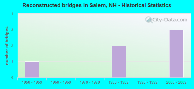
- Reconstructed bridges - Historical Statistics
- 11950-1959
- 01960-1969
- 01970-1979
- 21980-1989
- 01990-1999
- 32000-2009
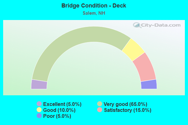
- Bridge Condition - Deck
- 5.0%Excellent
- 65.0%Very good
- 10.0%Good
- 15.0%Satisfactory
- 5.0%Poor

- Bridge Condition - Superstructure
- 5.0%Excellent
- 60.0%Very good
- 20.0%Good
- 10.0%Satisfactory
- 5.0%Poor
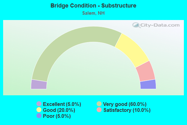
- Bridge Condition - Substructure
- 5.0%Excellent
- 60.0%Very good
- 20.0%Good
- 10.0%Satisfactory
- 5.0%Poor
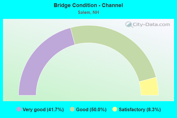
- Bridge Condition - Channel
- 41.7%Very good
- 50.0%Good
- 8.3%Satisfactory
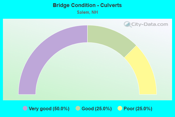
- Bridge Condition - Culverts
- 50.0%Very good
- 25.0%Good
- 25.0%Poor
Find on map >> Show street view
Structure Number: 228006000088, Location: 4 MI S WINDHAM TL (Lat: 42.783242, Lng: -71.255397), Route carried "on" structure: Other road , Year Built: 2012, Status: Open, Structure Length: 9.54m (31.30ft), Average Daily Traffic: 992 (year 2020), Truck Traffic: 4%, Average Future Daily Traffic: 1,468 (year 2042), Design Load: HS 25 or greater, Features Intersected: I-93, Facility Carried by Structure: BROOKDALE ROAD
Minimum Vertical Clearance: 30+ m (98+ ft), Kilometerpoint: 1.239, Lanes on structure: 2, Lanes under structure: 9, Owner: State Highway Agency, Approaching Roadway Width: 9.1m (29.9ft), Material/Design: Steel continuous, Design/Construction: Stringer/Multi-beam, Number Of Spans In Main Unit: 2, Length of Maximum Span: 47.2m (154.9ft), Curb or Sidewalk Widths: Left: 0.2m (0.7ft), Right: 0.2m (0.7ft), Curb-To-Curb Width: 9.1m (29.9ft), Out-to-Out Width: 10.1m (33.1ft)
Condition: Deck: Good, Superstructure: Good, Substructure: Very good, Operating Rating: 67.8 metric tons, Method Used To Determine Operating Rating: Load Factor (LF), Inventory Rating: 40.8 metric tons, Method Used To Determine Inventory Rating: Load Factor (LF), Structural Evaluation: Better than present minimum criteria, Deck Geometry: Equal to present minimum criteria, Underclear: Equal to present minimum criteria, Approach Roadway Alignment: Equal to present desirable criteria, Length Of Structure Improvement: 9.54m (31.30ft), Designated Inspection Frequency: Every 24 months, Inspection Date: May 2021, Bridge Improvement Cost: $2,718,000, Roadway Improvement Cost: $200,000, Total Project Cost: $3,142,000 ( Estimate for 2022), Deck Structure Type: Concrete Cast-file-Place, Wearing Surface/Protective System: Wearing Surface: Bituminous, Membrane: Preformed Fabric, Deck Protection: Epoxy Coated Reinforcing
Find on map >> Show street view
Structure Number: 228006700077, Location: 1.1 M N OF JCT RT 38 (Lat: 42.777283, Lng: -71.245031), Route carried "on" structure: Interstate 93, Year Built: 2014, Status: Open, Structure Length: 4.72m (15.49ft), Average Daily Traffic: 39,882 (year 2020), Truck Traffic: 9%, Average Future Daily Traffic: 59,025 (year 2042), Design Load: HS 25 or greater, Features Intersected: PELHAM ROAD
Minimum Vertical Clearance: 30+ m (98+ ft), Kilometerpoint: 207.446, Lanes on structure: 4, Lanes under structure: 8, Base Highway Network: Yes, Owner: State Highway Agency, Approaching Roadway Width: 21.6m (70.9ft), Skew: 1 degrees, Material/Design: Steel, Design/Construction: Stringer/Multi-beam, Number Of Spans In Main Unit: 1, Length of Maximum Span: 45.7m (149.9ft), Curb or Sidewalk Widths: Left: 0.2m (0.7ft), Right: 0.2m (0.7ft), Curb-To-Curb Width: 21.6m (70.9ft), Out-to-Out Width: 22.9m (75.1ft)
Condition: Deck: Very good, Superstructure: Very good, Substructure: Very good, Operating Rating: 70.0 metric tons, Method Used To Determine Operating Rating: Load Factor (LF), Inventory Rating: 42.0 metric tons, Method Used To Determine Inventory Rating: Load Factor (LF), Structural Evaluation: Equal to present desirable criteria, Deck Geometry: Better than present minimum criteria, Underclear: Superior to present desirable criteria, Approach Roadway Alignment: Better than present minimum criteria, Length Of Structure Improvement: 4.72m (15.49ft), Designated Inspection Frequency: Every 24 months, Inspection Date: May 2021, Bridge Improvement Cost: $2,718,000, Roadway Improvement Cost: $200,000, Total Project Cost: $3,142,000 ( Estimate for 2022), Deck Structure Type: Concrete Cast-file-Place, Wearing Surface/Protective System: Wearing Surface: Bituminous, Membrane: Preformed Fabric, Deck Protection: Epoxy Coated Reinforcing
Find on map >> Show street view
Structure Number: 22800710008, Location: 1.1 M N OF JCT 38 (Lat: 42.777636, Lng: -71.244525), Route carried "on" structure: Interstate 93, Year Built: 2014, Status: Open, Structure Length: 4.72m (15.49ft), Average Daily Traffic: 38,069 (year 2020), Truck Traffic: 9%, Average Future Daily Traffic: 56,342 (year 2042), Design Load: HS 25 or greater, Features Intersected: PELHAM ROAD
Minimum Vertical Clearance: 30+ m (98+ ft), Kilometerpoint: 4.830, Lanes on structure: 4, Lanes under structure: 8, Base Highway Network: Yes, Owner: State Highway Agency, Approaching Roadway Width: 21.6m (70.9ft), Skew: 1 degrees, Material/Design: Steel, Design/Construction: Stringer/Multi-beam, Number Of Spans In Main Unit: 1, Length of Maximum Span: 45.7m (149.9ft), Curb or Sidewalk Widths: Left: 0.2m (0.7ft), Right: 0.2m (0.7ft), Curb-To-Curb Width: 21.6m (70.9ft), Out-to-Out Width: 22.9m (75.1ft)
Condition: Deck: Good, Superstructure: Very good, Substructure: Very good, Operating Rating: 70.0 metric tons, Method Used To Determine Operating Rating: Load Factor (LF), Inventory Rating: 42.0 metric tons, Method Used To Determine Inventory Rating: Load Factor (LF), Structural Evaluation: Equal to present desirable criteria, Deck Geometry: Better than present minimum criteria, Underclear: High priority of replacement, Approach Roadway Alignment: Somewhat better than minimum adequacy, Length Of Structure Improvement: 4.72m (15.49ft), Designated Inspection Frequency: Every 24 months, Inspection Date: May 2021, Bridge Improvement Cost: $2,718,000, Roadway Improvement Cost: $200,000, Total Project Cost: $3,142,000 ( Estimate for 2022), Deck Structure Type: Concrete Cast-file-Place, Wearing Surface/Protective System: Wearing Surface: Bituminous, Membrane: Preformed Fabric, Deck Protection: Epoxy Coated Reinforcing
Find on map >> Show street view
Structure Number: 228007600063, Location: 2.0 ML N. OF MASS SL. (Lat: 42.765489, Lng: -71.238144), Route carried "on" structure: Interstate 93, Year Built: 2013, Status: Open, Structure Length: 4.02m (13.19ft), Average Daily Traffic: 41,767 (year 2020), Truck Traffic: 9%, Average Future Daily Traffic: 61,815 (year 2042), Design Load: HS 25 or greater, Features Intersected: NH 38
Minimum Vertical Clearance: 30+ m (98+ ft), Kilometerpoint: 208.875, Lanes on structure: 4, Lanes under structure: 2, Base Highway Network: Yes, Owner: State Highway Agency, Approaching Roadway Width: 21.6m (70.9ft), Skew: 2 degrees, Material/Design: Steel, Design/Construction: Stringer/Multi-beam, Number Of Spans In Main Unit: 1, Length of Maximum Span: 38.4m (126.0ft), Curb or Sidewalk Widths: Left: 0.2m (0.7ft), Right: 0.2m (0.7ft), Curb-To-Curb Width: 21.6m (70.9ft), Out-to-Out Width: 23.2m (76.1ft)
Condition: Deck: Very good, Superstructure: Very good, Substructure: Very good, Operating Rating: 68.2 metric tons, Method Used To Determine Operating Rating: Load Factor (LF), Inventory Rating: 40.8 metric tons, Method Used To Determine Inventory Rating: Load Factor (LF), Structural Evaluation: Equal to present desirable criteria, Deck Geometry: Better than present minimum criteria, Underclear: Equal to present minimum criteria, Approach Roadway Alignment: Equal to present desirable criteria, Length Of Structure Improvement: 4.02m (13.19ft), Designated Inspection Frequency: Every 24 months, Inspection Date: May 2021, Bridge Improvement Cost: $2,718,000, Roadway Improvement Cost: $200,000, Total Project Cost: $3,142,000 ( Estimate for 2022), Deck Structure Type: Concrete Cast-file-Place, Wearing Surface/Protective System: Wearing Surface: Bituminous, Membrane: Preformed Fabric, Deck Protection: Epoxy Coated Reinforcing
Find on map >> Show street view
Structure Number: 228007900063, Location: 2.0 MI N. OF NH/MA LINE (Lat: 42.765436, Lng: -71.236350), Route carried "on" structure: Interstate 93, Year Built: 2013, Status: Open, Structure Length: 4.05m (13.29ft), Average Daily Traffic: 40,844 (year 2020), Truck Traffic: 5%, Average Future Daily Traffic: 60,449 (year 2042), Design Load: HS 25 or greater, Features Intersected: NH 38
Minimum Vertical Clearance: 30+ m (98+ ft), Kilometerpoint: 3.322, Lanes on structure: 5, Lanes under structure: 2, Base Highway Network: Yes, Owner: State Highway Agency, Approaching Roadway Width: 25.6m (84.0ft), Skew: 2 degrees, Material/Design: Steel, Design/Construction: Stringer/Multi-beam, Number Of Spans In Main Unit: 1, Length of Maximum Span: 38.4m (126.0ft), Curb or Sidewalk Widths: Left: 0.2m (0.7ft), Right: 0.2m (0.7ft), Curb-To-Curb Width: 25.6m (84.0ft), Out-to-Out Width: 26.5m (86.9ft)
Condition: Deck: Very good, Superstructure: Very good, Substructure: Very good, Operating Rating: 69.4 metric tons, Method Used To Determine Operating Rating: Load Factor (LF), Inventory Rating: 41.6 metric tons, Method Used To Determine Inventory Rating: Load Factor (LF), Structural Evaluation: Equal to present desirable criteria, Deck Geometry: Better than present minimum criteria, Underclear: Equal to present minimum criteria, Approach Roadway Alignment: Equal to present desirable criteria, Length Of Structure Improvement: 4.05m (13.29ft), Designated Inspection Frequency: Every 24 months, Inspection Date: May 2021, Bridge Improvement Cost: $2,718,000, Roadway Improvement Cost: $200,000, Total Project Cost: $3,142,000 ( Estimate for 2022), Deck Structure Type: Concrete Cast-file-Place, Wearing Surface/Protective System: Wearing Surface: Bituminous, Membrane: Preformed Fabric, Deck Protection: Epoxy Coated Reinforcing
Find on map >> Show street view
Structure Number: 228008200061, Location: 0.25MI S. OF JCT RT 38 (Lat: 42.763333, Lng: -71.231481), Route carried "on" structure: City street 93, Year Built: 1960, Year Reconstructed: 2009, Status: Open, Structure Length: 4.48m (14.70ft), Average Daily Traffic: 12,499 (year 2020), Truck Traffic: 4%, Average Future Daily Traffic: 18,498 (year 2042), Design Load: HS 20+Mod, Features Intersected: SOUTH POLICY STREET
Minimum Vertical Clearance: 30+ m (98+ ft), Kilometerpoint: 0.040, Lanes on structure: 3, Lanes under structure: 2, Base Highway Network: Yes, Owner: State Highway Agency, Approaching Roadway Width: 11.6m (38.1ft), Skew: 1 degrees, Material/Design: Steel continuous, Design/Construction: Stringer/Multi-beam, Number Of Spans In Main Unit: 3, Length of Maximum Span: 18.0m (59.1ft), Curb or Sidewalk Widths: Left: 0.2m (0.7ft), Right: 0.2m (0.7ft), Curb-To-Curb Width: 11.9m (39.0ft), Out-to-Out Width: 13.7m (44.9ft)
Condition: Deck: Very good, Superstructure: Very good, Substructure: Very good, Operating Rating: 75.9 metric tons, Method Used To Determine Operating Rating: Load Factor (LF), Inventory Rating: 45.7 metric tons, Method Used To Determine Inventory Rating: Load Factor (LF), Structural Evaluation: Equal to present desirable criteria, Deck Geometry: High priority of replacement, Underclear: High priority of replacement, Approach Roadway Alignment: Equal to present desirable criteria, Length Of Structure Improvement: 4.48m (14.70ft), Designated Inspection Frequency: Every 24 months, Inspection Date: May 2021, Bridge Improvement Cost: $2,718,000, Roadway Improvement Cost: $200,000, Total Project Cost: $3,142,000 ( Estimate for 2022), Deck Structure Type: Concrete Precast Panels, Wearing Surface/Protective System: Wearing Surface: Bituminous, Membrane: Preformed Fabric, Deck Protection: Epoxy Coated Reinforcing
Find on map >> Show street view
Structure Number: 228008300056, Location: 0.2 MI S OF JCT NH 38 (Lat: 42.760725, Lng: -71.233772), Route carried "on" structure: Interstate 93, Year Built: 2008, Status: Open, Structure Length: 5.27m (17.29ft), Average Daily Traffic: 12,393 (year 2020), Truck Traffic: 6%, Average Future Daily Traffic: 18,341 (year 2042), Design Load: HS 20+Mod, Features Intersected: I-93 SB
Minimum Vertical Clearance: 30+ m (98+ ft), Kilometerpoint: 0.830, Lanes on structure: 3, Lanes under structure: 4, Base Highway Network: Yes, Owner: State Highway Agency, Approaching Roadway Width: 22.6m (74.1ft), Skew: 33 degrees, Material/Design: Steel, Design/Construction: Stringer/Multi-beam, Number Of Spans In Main Unit: 1, Length of Maximum Span: 50.3m (165.0ft), Curb or Sidewalk Widths: Left: 0.2m (0.7ft), Right: 0.2m (0.7ft), Curb-To-Curb Width: 23.2m (76.1ft), Out-to-Out Width: 24.7m (81.0ft)
Condition: Deck: Very good, Superstructure: Good, Substructure: Very good, Operating Rating: 71.0 metric tons, Method Used To Determine Operating Rating: Load Factor (LF), Inventory Rating: 42.5 metric tons, Method Used To Determine Inventory Rating: Load Factor (LF), Structural Evaluation: Better than present minimum criteria, Deck Geometry: Superior to present desirable criteria, Underclear: Somewhat better than minimum adequacy, Approach Roadway Alignment: Equal to present desirable criteria, Length Of Structure Improvement: 5.27m (17.29ft), Designated Inspection Frequency: Every 24 months, Inspection Date: May 2021, Bridge Improvement Cost: $2,718,000, Roadway Improvement Cost: $200,000, Total Project Cost: $3,142,000 ( Estimate for 2022), Deck Structure Type: Concrete Precast Panels, Wearing Surface/Protective System: Wearing Surface: Bituminous, Membrane: Preformed Fabric, Deck Protection: Epoxy Coated Reinforcing
Find on map >> Show street view
Structure Number: 228008300058, Location: .2 MI S OF JCT NH 38 (Lat: 42.761503, Lng: -71.233367), Route carried "on" structure: Interstate 93, Year Built: 2008, Status: Open, Structure Length: 4.66m (15.29ft), Average Daily Traffic: 12,393 (year 2020), Truck Traffic: 9%, Average Future Daily Traffic: 18,341 (year 2042), Design Load: HS 20+Mod, Features Intersected: I-93 NB
Minimum Vertical Clearance: 30+ m (98+ ft), Kilometerpoint: 0.295, Lanes on structure: 3, Lanes under structure: 4, Base Highway Network: Yes, Owner: State Highway Agency, Approaching Roadway Width: 22.6m (74.1ft), Skew: 32 degrees, Material/Design: Steel, Design/Construction: Stringer/Multi-beam, Number Of Spans In Main Unit: 1, Length of Maximum Span: 43.9m (144.0ft), Curb or Sidewalk Widths: Left: 0.1m (0.3ft), Right: 0.1m (0.3ft), Curb-To-Curb Width: 23.2m (76.1ft), Out-to-Out Width: 24.7m (81.0ft)
Condition: Deck: Very good, Superstructure: Good, Substructure: Satisfactory, Operating Rating: 75.9 metric tons, Method Used To Determine Operating Rating: Load Factor (LF), Inventory Rating: 45.4 metric tons, Method Used To Determine Inventory Rating: Load Factor (LF), Structural Evaluation: Equal to present minimum criteria, Deck Geometry: Superior to present desirable criteria, Underclear: Better than present minimum criteria, Approach Roadway Alignment: Equal to present desirable criteria, Length Of Structure Improvement: 4.66m (15.29ft), Designated Inspection Frequency: Every 24 months, Inspection Date: May 2021, Bridge Improvement Cost: $2,718,000, Roadway Improvement Cost: $200,000, Total Project Cost: $3,142,000 ( Estimate for 2022), Deck Structure Type: Concrete Precast Panels, Wearing Surface/Protective System: Wearing Surface: Bituminous, Membrane: Preformed Fabric, Deck Protection: Epoxy Coated Reinforcing
Find on map >> Show street view
Structure Number: 228008300061, Location: 0.25MI S. OF JCT RT 38 (Lat: 42.763261, Lng: -71.231369), Route carried "on" structure: Interstate 93, Year Built: 1965, Year Reconstructed: 2009, Status: Open, Structure Length: 4.45m (14.60ft), Average Daily Traffic: 3,274 (year 2020), Truck Traffic: 4%, Average Future Daily Traffic: 4,845 (year 2042), Design Load: HS 20+Mod, Features Intersected: SOUTH POLICY STREET
Minimum Vertical Clearance: 30+ m (98+ ft), Kilometerpoint: 1.181, Lanes on structure: 1, Lanes under structure: 2, Base Highway Network: Yes, Owner: State Highway Agency, Approaching Roadway Width: 6.1m (20.0ft), Skew: 1 degrees, Material/Design: Steel continuous, Design/Construction: Stringer/Multi-beam, Number Of Spans In Main Unit: 3, Length of Maximum Span: 18.3m (60.0ft), Curb or Sidewalk Widths: Left: 0.6m (2.0ft), Right: 0.0m, Curb-To-Curb Width: 6.1m (20.0ft), Out-to-Out Width: 8.2m (26.9ft)
Condition: Deck: Very good, Superstructure: Very good, Substructure: Very good, Operating Rating: 75.9 metric tons, Method Used To Determine Operating Rating: Load Factor (LF), Inventory Rating: 45.7 metric tons, Method Used To Determine Inventory Rating: Load Factor (LF), Structural Evaluation: Equal to present desirable criteria, Deck Geometry: High priority of replacement, Underclear: Meets minimum limits, Approach Roadway Alignment: Equal to present desirable criteria, Length Of Structure Improvement: 4.45m (14.60ft), Designated Inspection Frequency: Every 24 months, Inspection Date: May 2021, Bridge Improvement Cost: $2,718,000, Roadway Improvement Cost: $200,000, Total Project Cost: $3,142,000 ( Estimate for 2022), Deck Structure Type: Concrete Precast Panels, Wearing Surface/Protective System: Wearing Surface: Bituminous, Membrane: Preformed Fabric, Deck Protection: Epoxy Coated Reinforcing
Find on map >> Show street view
Structure Number: 228008400061, Location: 0.25MI S. OF JCT RT 38 (Lat: 42.763156, Lng: -71.231328), Route carried "on" structure: City street 93, Year Built: 1961, Year Reconstructed: 2008, Status: Open, Structure Length: 4.60m (15.09ft), Average Daily Traffic: 16,366 (year 2020), Truck Traffic: 6%, Average Future Daily Traffic: 24,221 (year 2042), Design Load: HS 20+Mod, Features Intersected: SOUTH POLICY STREET
Minimum Vertical Clearance: 30+ m (98+ ft), Kilometerpoint: 0.787, Lanes on structure: 3, Lanes under structure: 2, Base Highway Network: Yes, Owner: State Highway Agency, Approaching Roadway Width: 14.9m (48.9ft), Skew: 1 degrees, Material/Design: Steel, Design/Construction: Stringer/Multi-beam, Number Of Spans In Main Unit: 3, Length of Maximum Span: 18.0m (59.1ft), Curb or Sidewalk Widths: Left: 0.1m (0.3ft), Right: 0.1m (0.3ft), Curb-To-Curb Width: 14.9m (48.9ft), Out-to-Out Width: 15.5m (50.9ft)
Condition: Deck: Very good, Superstructure: Very good, Substructure: Good, Operating Rating: 75.9 metric tons, Method Used To Determine Operating Rating: Load Factor (LF), Inventory Rating: 45.7 metric tons, Method Used To Determine Inventory Rating: Load Factor (LF), Structural Evaluation: Better than present minimum criteria, Deck Geometry: Meets minimum limits, Underclear: Meets minimum limits, Approach Roadway Alignment: Equal to present desirable criteria, Length Of Structure Improvement: 4.60m (15.09ft), Designated Inspection Frequency: Every 24 months, Inspection Date: May 2021, Bridge Improvement Cost: $2,718,000, Roadway Improvement Cost: $200,000, Total Project Cost: $3,142,000 ( Estimate for 2022), Deck Structure Type: Concrete Precast Panels, Wearing Surface/Protective System: Wearing Surface: Bituminous, Membrane: Other, Deck Protection: Epoxy Coated Reinforcing
Find on map >> Show street view
Structure Number: 228008700063, Location: ROCKINGHAM MALL (Lat: 42.766506, Lng: -71.226997), Route carried "on" structure: Ramp Other road 93, Year Built: 1991, Status: Open, Structure Length: 44.38m (145.60ft), Average Daily Traffic: 4,006 (year 2020), Truck Traffic: 4%, Average Future Daily Traffic: 5,928 (year 2042), Design Load: HS 25 or greater, Features Intersected: ROCKHAM BLVD,BK,PARKNLOT, Facility Carried by Structure: ROCKNHAM MALL ENTR
Minimum Vertical Clearance: 30+ m (98+ ft), Kilometerpoint: 0.454, Lanes on structure: 2, Lanes under structure: 7, Base Highway Network: Yes, Owner: State Highway Agency, Approaching Roadway Width: 21.3m (69.9ft), Material/Design: Steel, Design/Construction: Stringer/Multi-beam, Number Of Spans In Main Unit: 13, Length of Maximum Span: 49.4m (162.1ft), Curb or Sidewalk Widths: Left: 0.2m (0.7ft), Right: 0.2m (0.7ft), Curb-To-Curb Width: 9.8m (32.2ft), Out-to-Out Width: 10.8m (35.4ft)
Condition: Deck: Satisfactory, Superstructure: Satisfactory, Substructure: Satisfactory, Operating Rating: 56.3 metric tons, Method Used To Determine Operating Rating: Load Factor (LF), Inventory Rating: 40.8 metric tons, Method Used To Determine Inventory Rating: Load Factor (LF), Structural Evaluation: Equal to present minimum criteria, Deck Geometry: Equal to present minimum criteria, Underclear: High priority of replacement, Approach Roadway Alignment: Superior to present desirable criteria, Length Of Structure Improvement: 44.38m (145.60ft), Designated Inspection Frequency: Every 24 months, Critical Feature Inspection Frequency: Every 24 months, Inspection Date: May 2021, Critical Feature Inspection Date: May 2021, Bridge Improvement Cost: $2,718,000, Roadway Improvement Cost: $200,000, Total Project Cost: $3,142,000 ( Estimate for 2022), Deck Structure Type: Concrete Cast-file-Place, Wearing Surface/Protective System: Wearing Surface: Bituminous, Membrane: Preformed Fabric, Deck Protection: Epoxy Coated Reinforcing
Find on map >> Show street view
Structure Number: 228008800053, Location: 1.2 MI N OF MASS SL (Lat: 42.756672, Lng: -71.227169), Route carried "on" structure: City street , Year Built: 2007, Status: Open, Structure Length: 13.20m (43.31ft), Average Daily Traffic: 5,919 (year 2020), Truck Traffic: 4%, Average Future Daily Traffic: 8,760 (year 2042), Design Load: HS 20, Features Intersected: I-93, Facility Carried by Structure: CROSS STREET
Minimum Vertical Clearance: 30+ m (98+ ft), Kilometerpoint: 1.638, Lanes on structure: 2, Lanes under structure: 11, Owner: State Highway Agency, Approaching Roadway Width: 9.1m (29.9ft), Skew: 3 degrees, Material/Design: Steel continuous, Design/Construction: Stringer/Multi-beam, Number Of Spans In Main Unit: 2, Length of Maximum Span: 70.1m (230.0ft), Curb or Sidewalk Widths: Left: 0.2m (0.7ft), Right: 1.5m (4.9ft), Curb-To-Curb Width: 9.0m (29.5ft), Out-to-Out Width: 11.6m (38.1ft)
Condition: Deck: Very good, Superstructure: Very good, Substructure: Good, Operating Rating: 62.7 metric tons, Method Used To Determine Operating Rating: Load Factor (LF), Inventory Rating: 37.6 metric tons, Method Used To Determine Inventory Rating: Load Factor (LF), Structural Evaluation: Better than present minimum criteria, Deck Geometry: Meets minimum limits, Underclear: Meets minimum limits, Approach Roadway Alignment: Equal to present desirable criteria, Length Of Structure Improvement: 13.20m (43.31ft), Designated Inspection Frequency: Every 24 months, Inspection Date: May 2021, Bridge Improvement Cost: $2,718,000, Roadway Improvement Cost: $200,000, Total Project Cost: $3,142,000 ( Estimate for 2022), Deck Structure Type: Concrete Precast Panels, Wearing Surface/Protective System: Wearing Surface: Bituminous, Membrane: Preformed Fabric, Deck Protection: Epoxy Coated Reinforcing
Find on map >> Show street view
Structure Number: 228009400119, Location: 2.3 MI FROM MASS. SL (Lat: 42.805258, Lng: -71.218353), Route carried "on" structure: Other road , Year Built: 2013, Status: Open, Structure Length: 0.79m (2.59ft), Average Daily Traffic: 1,869 (year 2020), Truck Traffic: 3%, Average Future Daily Traffic: 2,766 (year 2042), Design Load: HL 93, Features Intersected: HITTYTITY BROOK, Facility Carried by Structure: BLUFF STREET
Minimum Vertical Clearance: 30+ m (98+ ft), Kilometerpoint: 2.441, Lanes on structure: 2, Owner: City or Municipal Highway Agency, Approaching Roadway Width: 7.9m (25.9ft), Skew: 1 degrees, Material/Design: Concrete, Design/Construction: Culvert, Number Of Spans In Main Unit: 1, Length of Maximum Span: 7.3m (24.0ft), Curb or Sidewalk Widths: Left: 0.2m (0.7ft), Right: 0.0m
Condition: Channel: Very good, Culverts: Very good, Operating Rating: 89.8 metric tons, Method Used To Determine Operating Rating: Load Factor (LF), Inventory Rating: 77.6 metric tons, Method Used To Determine Inventory Rating: Load Factor (LF), Structural Evaluation: Equal to present desirable criteria, Waterway Adequacy: Equal to present desirable criteria, Approach Roadway Alignment: Equal to present minimum criteria, Length Of Structure Improvement: 0.79m (2.59ft), Designated Inspection Frequency: Every 24 months, Inspection Date: August 2021, Bridge Improvement Cost: $2,718,000, Roadway Improvement Cost: $200,000, Total Project Cost: $3,142,000 ( Estimate for 2022), Wearing Surface/Protective System: Wearing Surface: Bituminous
Find on map >> Show street view
Structure Number: 228009500052, Location: REST AREA EXIT ROAD (Lat: 42.754089, Lng: -71.221017), Route carried "on" structure: Ramp Other road 93, Year Built: 1967, Status: Open, Structure Length: 0.81m (2.66ft), Average Daily Traffic: 1,800 (year 2000), Truck Traffic: 9%, Average Future Daily Traffic: 2,664 (year 2042), Design Load: HS 20+Mod, Features Intersected: POLICY BROOK
Minimum Vertical Clearance: 30+ m (98+ ft), Kilometerpoint: 0.903, Lanes on structure: 1, Owner: State Highway Agency, Approaching Roadway Width: 6.4m (21.0ft), Skew: 5 degrees, Material/Design: Steel, Design/Construction: Culvert, Number Of Spans In Main Unit: 2, Length of Maximum Span: 3.5m (11.5ft)
Condition: Channel: Good, Culverts: Poor, Operating Rating: 89.8 metric tons, Method Used To Determine Operating Rating: Load Factor (LF), Inventory Rating: 89.8 metric tons, Method Used To Determine Inventory Rating: Load Factor (LF), Structural Evaluation: Meets minimum limits, Waterway Adequacy: Equal to present minimum criteria, Approach Roadway Alignment: Equal to present minimum criteria, Length Of Structure Improvement: 0.81m (2.66ft), Designated Inspection Frequency: Every 8 months, Inspection Date: November 2021, Bridge Improvement Cost: $2,718,000, Roadway Improvement Cost: $200,000, Total Project Cost: $3,142,000 ( Estimate for 2022)
Find on map >> Show street view
Structure Number: 228009500175, Location: 100' SOUTH PARKER CIR. (Lat: 42.843392, Lng: -71.216250), Route carried "on" structure: Other road , Year Built: 2014, Status: Open, Structure Length: 1.10m (3.61ft), Average Daily Traffic: 399 (year 2020), Average Future Daily Traffic: 590 (year 2042), Design Load: HL 93, Features Intersected: SPICKET RIVER, Facility Carried by Structure: TEAGUE DRIVE
Minimum Vertical Clearance: 30+ m (98+ ft), Kilometerpoint: 0.035, Lanes on structure: 2, Owner: City or Municipal Highway Agency, Approaching Roadway Width: 9.4m (30.8ft), Material/Design: Concrete, Design/Construction: Frame, Number Of Spans In Main Unit: 2, Length of Maximum Span: 4.9m (16.1ft), Curb or Sidewalk Widths: Left: 0.2m (0.7ft), Right: 0.2m (0.7ft), Curb-To-Curb Width: 9.4m (30.8ft), Out-to-Out Width: 10.7m (35.1ft)
Condition: Deck: Very good, Superstructure: Very good, Substructure: Very good, Channel: Good, Operating Rating: 46.4 metric tons, Method Used To Determine Operating Rating: Load and Resistance Factor (LRFR), Inventory Rating: 35.6 metric tons, Method Used To Determine Inventory Rating: Load and Resistance Factor (LRFR), Structural Evaluation: Equal to present desirable criteria, Deck Geometry: Equal to present minimum criteria, Waterway Adequacy: Somewhat better than minimum adequacy, Approach Roadway Alignment: Equal to present desirable criteria, Length Of Structure Improvement: 1.10m (3.61ft), Designated Inspection Frequency: Every 24 months, Inspection Date: August 2021, Bridge Improvement Cost: $2,718,000, Roadway Improvement Cost: $200,000, Total Project Cost: $3,142,000 ( Estimate for 2022), Deck Structure Type: Concrete Precast Panels, Wearing Surface/Protective System: Wearing Surface: Bituminous, Membrane: Preformed Fabric, Deck Protection: Epoxy Coated Reinforcing
Find on map >> Show street view
Structure Number: 228009700181, Location: COWBELL CORNER (Lat: 42.849217, Lng: -71.214953), Route carried "on" structure: Other road , Year Built: 2008, Status: Open, Structure Length: 0.67m (2.20ft), Average Daily Traffic: 1,838 (year 2020), Truck Traffic: 4%, Average Future Daily Traffic: 2,720 (year 2042), Design Load: HS 25 or greater, Features Intersected: SPICKET RIVER, Facility Carried by Structure: HAVERHILL ROAD
Minimum Vertical Clearance: 30+ m (98+ ft), Kilometerpoint: 3.711, Lanes on structure: 2, Owner: City or Municipal Highway Agency, Approaching Roadway Width: 7.6m (24.9ft), Material/Design: Concrete, Design/Construction: Frame, Number Of Spans In Main Unit: 1, Length of Maximum Span: 6.1m (20.0ft), Curb or Sidewalk Widths: Left: 0.1m (0.3ft), Right: 0.1m (0.3ft), Curb-To-Curb Width: 7.3m (24.0ft), Out-to-Out Width: 8.2m (26.9ft)
Condition: Deck: Very good, Superstructure: Very good, Substructure: Very good, Channel: Very good, Operating Rating: 78.0 metric tons, Method Used To Determine Operating Rating: Load Factor (LF), Inventory Rating: 54.0 metric tons, Method Used To Determine Inventory Rating: Load Factor (LF), Structural Evaluation: Equal to present desirable criteria, Deck Geometry: Meets minimum limits, Waterway Adequacy: Equal to present desirable criteria, Approach Roadway Alignment: Meets minimum limits, Length Of Structure Improvement: 0.67m (2.20ft), Designated Inspection Frequency: Every 24 months, Inspection Date: August 2021, Bridge Improvement Cost: $2,718,000, Roadway Improvement Cost: $200,000, Total Project Cost: $3,142,000 ( Estimate for 2022), Deck Structure Type: Concrete Precast Panels, Wearing Surface/Protective System: Wearing Surface: Bituminous, Membrane: Other
Find on map >> Show street view
Structure Number: 228009800049, Location: REST AREA ENTRANCE ROAD (Lat: 42.753656, Lng: -71.220072), Route carried "on" structure: ServiceOther road 93, Year Built: 1967, Year Reconstructed: 2021, Status: Open, Structure Length: 0.81m (2.66ft), Average Daily Traffic: 1,800 (year 2000), Truck Traffic: 9%, Average Future Daily Traffic: 2,664 (year 2042), Design Load: HS 20+Mod, Features Intersected: POLICY BROOK
Minimum Vertical Clearance: 30+ m (98+ ft), Kilometerpoint: 0.241, Lanes on structure: 1, Owner: State Highway Agency, Approaching Roadway Width: 6.4m (21.0ft), Skew: 5 degrees, Material/Design: Steel, Design/Construction: Culvert, Number Of Spans In Main Unit: 2, Length of Maximum Span: 3.5m (11.5ft)
Condition: Channel: Good, Culverts: Good, Operating Rating: 89.8 metric tons, Method Used To Determine Operating Rating: Load Factor (LF), Inventory Rating: 89.8 metric tons, Method Used To Determine Inventory Rating: Load Factor (LF), Structural Evaluation: Better than present minimum criteria, Waterway Adequacy: Equal to present desirable criteria, Approach Roadway Alignment: Equal to present minimum criteria, Length Of Structure Improvement: 0.81m (2.66ft), Designated Inspection Frequency: Every 24 months, Inspection Date: November 2021, Bridge Improvement Cost: $2,718,000, Roadway Improvement Cost: $200,000, Total Project Cost: $3,142,000 ( Estimate for 2022)
Find on map >> Show street view
Structure Number: 228010400073, Location: 4 TENTHS MIL EAST NH 28 (Lat: 42.771722, Lng: -71.213342), Route carried "on" structure: Alternate City street , Year Built: 2006, Status: Open, Structure Length: 5.12m (16.80ft), Average Daily Traffic: 399 (year 2020), Truck Traffic: 1%, Average Future Daily Traffic: 590 (year 2042), Design Load: HL 93, Features Intersected: SPICKET RIVER TRIBUTARY, Facility Carried by Structure: BRAEMOOR WOODS RD
Minimum Vertical Clearance: 30+ m (98+ ft), Kilometerpoint: 0.066, Lanes on structure: 2, Owner: City or Municipal Highway Agency, Approaching Roadway Width: 7.3m (24.0ft), Material/Design: Concrete, Design/Construction: Culvert, Number Of Spans In Main Unit: 3, Length of Maximum Span: 16.5m (54.1ft), Curb or Sidewalk Widths: Left: 1.5m (4.9ft), Right: 1.5m (4.9ft), Curb-To-Curb Width: 7.3m (24.0ft), Out-to-Out Width: 12.2m (40.0ft)
Condition: Channel: Good, Culverts: Very good, Operating Rating: 54.5 metric tons, Method Used To Determine Operating Rating: Load and Resistance Factor (LRFR), Inventory Rating: 41.4 metric tons, Method Used To Determine Inventory Rating: Load and Resistance Factor (LRFR), Structural Evaluation: Equal to present desirable criteria, Deck Geometry: Somewhat better than minimum adequacy, Waterway Adequacy: Better than present minimum criteria, Approach Roadway Alignment: Equal to present desirable criteria, Length Of Structure Improvement: 5.12m (16.80ft), Designated Inspection Frequency: Every 24 months, Inspection Date: August 2021, Bridge Improvement Cost: $2,718,000, Roadway Improvement Cost: $200,000, Total Project Cost: $3,142,000 ( Estimate for 2022)
Find on map >> Show street view
Structure Number: 228010900049, Location: 1.1MI N. OF MASS SL (Lat: 42.754372, Lng: -71.208172), Route carried "on" structure: State highway 28, Year Built: 1900, Year Reconstructed: 1986, Status: Open, Structure Length: 0.79m (2.59ft), Average Daily Traffic: 15,994 (year 2020), Truck Traffic: 5%, Average Future Daily Traffic: 23,671 (year 2042), Design Load: HS 20+Mod, Features Intersected: SPICKET RIVER
Minimum Vertical Clearance: 30+ m (98+ ft), Kilometerpoint: 1.748, Lanes on structure: 6, Base Highway Network: Yes, Owner: City or Municipal Highway Agency, Approaching Roadway Width: 21.3m (69.9ft), Material/Design: Concrete, Design/Construction: Slab, Number Of Spans In Main Unit: 1, Length of Maximum Span: 7.3m (24.0ft), Curb or Sidewalk Widths: Left: 1.5m (4.9ft), Right: 1.5m (4.9ft), Curb-To-Curb Width: 22.6m (74.1ft), Out-to-Out Width: 26.8m (87.9ft)
Condition: Deck: Satisfactory, Superstructure: Satisfactory, Substructure: Good, Channel: Good, Operating Rating: 45.1 metric tons, Method Used To Determine Operating Rating: Load Factor (LF), Inventory Rating: 32.7 metric tons, Method Used To Determine Inventory Rating: Load Factor (LF), Structural Evaluation: Equal to present minimum criteria, Deck Geometry: Meets minimum limits, Waterway Adequacy: Equal to present desirable criteria, Approach Roadway Alignment: Equal to present desirable criteria, Length Of Structure Improvement: 0.79m (2.59ft), Designated Inspection Frequency: Every 24 months, Inspection Date: August 2021, Bridge Improvement Cost: $2,718,000, Roadway Improvement Cost: $200,000, Total Project Cost: $3,142,000 ( Estimate for 2022), Deck Structure Type: Concrete Cast-file-Place, Wearing Surface/Protective System: Wearing Surface: Bituminous, Membrane: Other
Find on map >> Show street view
Structure Number: 22801130007, Location: 1.08 MI FR MASS SL (Lat: 42.768858, Lng: -71.202028), Route carried "on" structure: Other road , Year Built: 2010, Status: Open, Structure Length: 2.19m (7.19ft), Average Daily Traffic: 5,524 (year 2020), Truck Traffic: 3%, Average Future Daily Traffic: 8,175 (year 2042), Design Load: HL 93, Features Intersected: SPICKET RIVER, Facility Carried by Structure: LAWRENCE ROAD
Minimum Vertical Clearance: 30+ m (98+ ft), Kilometerpoint: 0.217, Lanes on structure: 2, Owner: City or Municipal Highway Agency, Approaching Roadway Width: 8.5m (27.9ft), Material/Design: Prestressed concrete, Design/Construction: Box Beam or Girders - Multiple, Number Of Spans In Main Unit: 1, Length of Maximum Span: 20.4m (66.9ft), Curb or Sidewalk Widths: Left: 0.2m (0.7ft), Right: 0.2m (0.7ft), Curb-To-Curb Width: 8.8m (28.9ft), Out-to-Out Width: 10.1m (33.1ft)
Condition: Deck: Very good, Superstructure: Very good, Substructure: Very good, Channel: Very good, Operating Rating: 89.8 metric tons, Method Used To Determine Operating Rating: Load Factor (LF), Inventory Rating: 73.9 metric tons, Method Used To Determine Inventory Rating: Load Factor (LF), Structural Evaluation: Equal to present desirable criteria, Deck Geometry: High priority of replacement, Waterway Adequacy: Equal to present desirable criteria, Approach Roadway Alignment: Equal to present minimum criteria, Length Of Structure Improvement: 2.19m (7.19ft), Designated Inspection Frequency: Every 24 months, Inspection Date: August 2021, Bridge Improvement Cost: $2,718,000, Roadway Improvement Cost: $200,000, Total Project Cost: $3,142,000 ( Estimate for 2022), Deck Structure Type: Concrete Cast-file-Place, Wearing Surface/Protective System: Wearing Surface: Bituminous, Membrane: Preformed Fabric, Deck Protection: Epoxy Coated Reinforcing
Find on map >> Show street view
Structure Number: 228011500097, Location: 1.0MI MASS SL (Lat: 42.787928, Lng: -71.199803), Route carried "on" structure: State highway , Year Built: 1900, Year Reconstructed: 1959, Status: Open, Structure Length: 0.88m (2.89ft), Average Daily Traffic: 4,834 (year 2020), Truck Traffic: 3%, Average Future Daily Traffic: 7,154 (year 2042), Features Intersected: SPICKET RIVER, Facility Carried by Structure: BRIDGE STREET
Minimum Vertical Clearance: 30+ m (98+ ft), Kilometerpoint: 0.119, Lanes on structure: 2, Owner: City or Municipal Highway Agency, Approaching Roadway Width: 8.5m (27.9ft), Material/Design: Steel, Design/Construction: Stringer/Multi-beam, Number Of Spans In Main Unit: 1, Length of Maximum Span: 7.6m (24.9ft), Curb or Sidewalk Widths: Left: 0.2m (0.7ft), Right: 1.3m (4.3ft), Curb-To-Curb Width: 8.5m (27.9ft), Out-to-Out Width: 10.7m (35.1ft)
Condition: Deck: Poor, Superstructure: Poor, Substructure: Poor, Channel: Good, Operating Rating: 22.9 metric tons, Method Used To Determine Operating Rating: Allowable Stress (AS), Inventory Rating: 16.1 metric tons, Method Used To Determine Inventory Rating: Allowable Stress (AS), Structural Evaluation: Meets minimum limits, Deck Geometry: Meets minimum limits, Waterway Adequacy: Equal to present desirable criteria, Approach Roadway Alignment: Equal to present desirable criteria, Length Of Structure Improvement: 0.88m (2.89ft), Designated Inspection Frequency: Every 16 months, Inspection Date: November 2021, Bridge Improvement Cost: $2,718,000, Roadway Improvement Cost: $200,000, Total Project Cost: $3,142,000 ( Estimate for 2022), Deck Structure Type: Concrete Cast-file-Place, Wearing Surface/Protective System: Wearing Surface: Bituminous
Find on map >> Show street view
Structure Number: 228011600116, Location: 500 FEET FROM TOWN FARM R (Lat: 42.802028, Lng: -71.197539), Route carried "on" structure: City street , Year Built: 2020, Status: Open, Structure Length: 1.07m (3.51ft), Average Daily Traffic: 3,038 (year 2020), Truck Traffic: 4%, Average Future Daily Traffic: 4,496 (year 2042), Design Load: HL 93, Features Intersected: WIDOW HARRIS BROOK, Facility Carried by Structure: BLUFF STREET EXT
Minimum Vertical Clearance: 30+ m (98+ ft), Kilometerpoint: 4.266, Lanes on structure: 2, Owner: City or Municipal Highway Agency, Approaching Roadway Width: 7.3m (24.0ft), Material/Design: Concrete, Design/Construction: Frame, Number Of Spans In Main Unit: 2, Length of Maximum Span: 4.9m (16.1ft), Curb or Sidewalk Widths: Left: 0.2m (0.7ft), Right: 0.2m (0.7ft), Curb-To-Curb Width: 7.9m (25.9ft), Out-to-Out Width: 9.1m (29.9ft)
Condition: Deck: Excellent, Superstructure: Excellent, Substructure: Excellent, Channel: Very good, Operating Rating: 59.3 metric tons, Method Used To Determine Operating Rating: Load and Resistance Factor (LRFR), Inventory Rating: 45.6 metric tons, Method Used To Determine Inventory Rating: Load and Resistance Factor (LRFR), Structural Evaluation: Superior to present desirable criteria, Deck Geometry: High priority of corrective action, Waterway Adequacy: Better than present minimum criteria, Approach Roadway Alignment: Better than present minimum criteria, Length Of Structure Improvement: 1.07m (3.51ft), Designated Inspection Frequency: Every 24 months, Inspection Date: December 2021, Bridge Improvement Cost: $2,718,000, Roadway Improvement Cost: $200,000, Total Project Cost: $3,142,000 ( Estimate for 2022), Deck Structure Type: Concrete Precast Panels, Wearing Surface/Protective System: Wearing Surface: Bituminous, Membrane: Preformed Fabric, Deck Protection: Epoxy Coated Reinforcing
Find on map >> Show street view
Structure Number: 228011800104, Location: .5MI W MASS SL (Lat: 42.792850, Lng: -71.196639), Route carried "on" structure: State highway 97, Year Built: 1958, Year Reconstructed: 1994, Status: Open, Structure Length: 1.77m (5.81ft), Average Daily Traffic: 14,284 (year 2020), Truck Traffic: 5%, Average Future Daily Traffic: 21,140 (year 2042), Design Load: HS 25 or greater, Features Intersected: SPICKET RIVER
Minimum Vertical Clearance: 30+ m (98+ ft), Kilometerpoint: 3.135, Lanes on structure: 2, Owner: State Highway Agency, Approaching Roadway Width: 13.4m (44.0ft), Material/Design: Steel, Design/Construction: Stringer/Multi-beam, Number Of Spans In Main Unit: 1, Length of Maximum Span: 16.5m (54.1ft), Curb or Sidewalk Widths: Left: 0.2m (0.7ft), Right: 0.2m (0.7ft), Curb-To-Curb Width: 13.4m (44.0ft), Out-to-Out Width: 14.5m (47.6ft)
Condition: Deck: Satisfactory, Superstructure: Good, Substructure: Good, Channel: Satisfactory, Operating Rating: 74.8 metric tons, Method Used To Determine Operating Rating: Load Factor (LF), Inventory Rating: 44.9 metric tons, Method Used To Determine Inventory Rating: Load Factor (LF), Structural Evaluation: Better than present minimum criteria, Deck Geometry: Equal to present minimum criteria, Waterway Adequacy: Equal to present minimum criteria, Approach Roadway Alignment: Equal to present desirable criteria, Length Of Structure Improvement: 1.77m (5.81ft), Designated Inspection Frequency: Every 24 months, Inspection Date: May 2021, Bridge Improvement Cost: $2,718,000, Roadway Improvement Cost: $200,000, Total Project Cost: $3,142,000 ( Estimate for 2022), Deck Structure Type: Concrete Cast-file-Place, Wearing Surface/Protective System: Wearing Surface: Bituminous, Membrane: Preformed Fabric, Deck Protection: Epoxy Coated Reinforcing
Find on map >> Show street view
Structure Number: 228011800116, Location: 1.10 MI FROM MASS. SL (Lat: 42.801925, Lng: -71.195386), Route carried "on" structure: City street , Year Built: 2016, Status: Open, Structure Length: 1.40m (4.59ft), Average Daily Traffic: 3,038 (year 2020), Truck Traffic: 3%, Average Future Daily Traffic: 4,496 (year 2042), Design Load: HL 93, Features Intersected: SPICKET RIVER, Facility Carried by Structure: TOWN FARM ROAD
Minimum Vertical Clearance: 30+ m (98+ ft), Kilometerpoint: 4.439, Lanes on structure: 2, Owner: City or Municipal Highway Agency, Approaching Roadway Width: 8.2m (26.9ft), Material/Design: Prestressed concrete, Design/Construction: Slab, Number Of Spans In Main Unit: 1, Length of Maximum Span: 12.2m (40.0ft), Curb or Sidewalk Widths: Left: 0.2m (0.7ft), Right: 0.2m (0.7ft), Curb-To-Curb Width: 8.1m (26.6ft), Out-to-Out Width: 9.1m (29.9ft)
Condition: Deck: Very good, Superstructure: Very good, Substructure: Very good, Channel: Very good, Operating Rating: 92.7 metric tons, Method Used To Determine Operating Rating: Load and Resistance Factor (LRFR), Inventory Rating: 69.8 metric tons, Method Used To Determine Inventory Rating: Load and Resistance Factor (LRFR), Structural Evaluation: Equal to present desirable criteria, Deck Geometry: High priority of corrective action, Waterway Adequacy: Equal to present desirable criteria, Approach Roadway Alignment: Equal to present minimum criteria, Length Of Structure Improvement: 1.40m (4.59ft), Designated Inspection Frequency: Every 24 months, Inspection Date: August 2021, Bridge Improvement Cost: $2,718,000, Roadway Improvement Cost: $200,000, Total Project Cost: $3,142,000 ( Estimate for 2022), Deck Structure Type: Concrete Precast Panels, Wearing Surface/Protective System: Wearing Surface: Bituminous, Membrane: Preformed Fabric, Deck Protection: Epoxy Coated Reinforcing
Find on map >> Show street view
Structure Number: 228006000088, Location: 4 MI S WINDHAM TL (Lat: 42.783242, Lng: -71.255397), Route carried "under" structure: Interstate 93, Year Built: 2012, Structure Length: 0. m, Average Daily Traffic: 80,000 (year 2012), Truck Traffic: 5%, Features Intersected: I-93, Facility Carried by Structure: BROOKDALE ROAD
Minimum Vertical Clearance: 5.24m (17.19ft), Kilometerpoint: 0.000, Lanes on structure: 2, Lanes under structure: 9, Material/Design: Steel continuous, Design/Construction: Stringer/Multi-beam, Length of Maximum Span: 47.2m (154.9ft)
Find on map >> Show street view
Structure Number: 228006700077, Location: 1.1 M N OF JCT RT 38 (Lat: 42.777283, Lng: -71.245031), Route carried "under" structure: City street , Year Built: 2014, Structure Length: 0. m, Average Daily Traffic: 12,000 (year 2012), Truck Traffic: 2%, Features Intersected: PELHAM ROAD, Facility Carried by Structure: I-93 SB
Minimum Vertical Clearance: 6.12m (20.08ft), Kilometerpoint: 0.000, Lanes on structure: 4, Lanes under structure: 8, Material/Design: Steel, Design/Construction: Stringer/Multi-beam, Length of Maximum Span: 45.7m (149.9ft)
Find on map >> Show street view
Structure Number: 22800710008, Location: 1.1 M N OF JCT 38 (Lat: 42.777636, Lng: -71.244525), Route carried "under" structure: City street , Year Built: 2014, Structure Length: 0. m, Average Daily Traffic: 12,000 (year 2012), Truck Traffic: 2%, Features Intersected: PELHAM ROAD, Facility Carried by Structure: I-93 NB
Minimum Vertical Clearance: 6.81m (22.34ft), Kilometerpoint: 0.000, Lanes on structure: 4, Lanes under structure: 8, Material/Design: Steel, Design/Construction: Stringer/Multi-beam, Length of Maximum Span: 45.7m (149.9ft)
Find on map >> Show street view
Structure Number: 228007600063, Location: 2.0 ML N. OF MASS SL. (Lat: 42.765489, Lng: -71.238144), Route carried "under" structure: State highway 38, Year Built: 2013, Structure Length: 0. m, Average Daily Traffic: 12,000 (year 2013), Truck Traffic: 1%, Features Intersected: NH 38, Facility Carried by Structure: I-93 SB
Minimum Vertical Clearance: 4.82m (15.81ft), Kilometerpoint: 0.000, Lanes on structure: 4, Lanes under structure: 2, Material/Design: Steel, Design/Construction: Stringer/Multi-beam, Length of Maximum Span: 38.4m (126.0ft)
Find on map >> Show street view
Structure Number: 228007900063, Location: 2.0 MI N. OF NH/MA LINE (Lat: 42.765436, Lng: -71.236350), Route carried "under" structure: State highway 38, Year Built: 2013, Structure Length: 0. m, Average Daily Traffic: 12,000 (year 2013), Truck Traffic: 1%, Features Intersected: NH 38, Facility Carried by Structure: I-93 NB
Minimum Vertical Clearance: 4.97m (16.31ft), Kilometerpoint: 11.909, Lanes on structure: 5, Lanes under structure: 2, Material/Design: Steel, Design/Construction: Stringer/Multi-beam, Length of Maximum Span: 38.4m (126.0ft)
Find on map >> Show street view
Structure Number: 228008200061, Location: 0.25MI S. OF JCT RT 38 (Lat: 42.763333, Lng: -71.231481), Route carried "under" structure: City street , Year Built: 1960, Structure Length: 0. m, Average Daily Traffic: 10,000 (year 2013), Features Intersected: SOUTH POLICY STREET, Facility Carried by Structure: I-93 ON RAMPS
Minimum Vertical Clearance: 5.44m (17.85ft), Kilometerpoint: 0.000, Lanes on structure: 3, Lanes under structure: 2, Material/Design: Steel continuous, Design/Construction: Stringer/Multi-beam, Length of Maximum Span: 18.0m (59.1ft)
Find on map >> Show street view
Structure Number: 228008300056, Location: 0.2 MI S OF JCT NH 38 (Lat: 42.760725, Lng: -71.233772), Route carried "under" structure: Interstate 93, Year Built: 2008, Structure Length: 0. m, Average Daily Traffic: 40,500 (year 2012), Truck Traffic: 9%, Features Intersected: I-93 SB
Minimum Vertical Clearance: 5.57m (18.27ft), Kilometerpoint: 0.000, Lanes on structure: 3, Lanes under structure: 4, Material/Design: Steel, Design/Construction: Stringer/Multi-beam, Length of Maximum Span: 50.3m (165.0ft)
Find on map >> Show street view
Structure Number: 228008300058, Location: .2 MI S OF JCT NH 38 (Lat: 42.761503, Lng: -71.233367), Route carried "under" structure: Interstate 93, Year Built: 2008, Structure Length: 0. m, Average Daily Traffic: 40,500 (year 2012), Truck Traffic: 6%, Features Intersected: I-93 NB
Minimum Vertical Clearance: 5.12m (16.80ft), Kilometerpoint: 0.000, Lanes on structure: 3, Lanes under structure: 4, Material/Design: Steel, Design/Construction: Stringer/Multi-beam, Length of Maximum Span: 43.9m (144.0ft)
Find on map >> Show street view
Structure Number: 228008300061, Location: 0.25MI S. OF JCT RT 38 (Lat: 42.763261, Lng: -71.231369), Route carried "under" structure: City street , Year Built: 1965, Structure Length: 0. m, Average Daily Traffic: 10,000 (year 2013), Features Intersected: SOUTH POLICY STREET, Facility Carried by Structure: I-93 SB OFF RAMP
Minimum Vertical Clearance: 5.59m (18.34ft), Kilometerpoint: 0.000, Lanes on structure: 1, Lanes under structure: 2, Material/Design: Steel continuous, Design/Construction: Stringer/Multi-beam, Length of Maximum Span: 18.3m (60.0ft)
Find on map >> Show street view
Structure Number: 228008400061, Location: 0.25MI S. OF JCT RT 38 (Lat: 42.763156, Lng: -71.231328), Route carried "under" structure: City street , Year Built: 1961, Structure Length: 0. m, Average Daily Traffic: 10,000 (year 2013), Features Intersected: SOUTH POLICY STREET, Facility Carried by Structure: I-93 NB OFF RAMP
Minimum Vertical Clearance: 5.23m (17.16ft), Kilometerpoint: 0.000, Lanes on structure: 3, Lanes under structure: 2, Material/Design: Steel, Design/Construction: Stringer/Multi-beam, Length of Maximum Span: 18.0m (59.1ft)
Find on map >> Show street view
Structure Number: 228008700063, Location: ROCKINGHAM MALL (Lat: 42.766506, Lng: -71.226997), Route carried "under" structure: Ramp City street 93, Year Built: 1991, Structure Length: 0. m, Average Daily Traffic: 31,400 (year 2019), Truck Traffic: 6%, Features Intersected: ROCKHAM BLVD,BK,PARKNLOT, Facility Carried by Structure: ROCKNHAM MALL ENTR
Minimum Vertical Clearance: 5.56m (18.24ft), Kilometerpoint: 0.000, Lanes on structure: 2, Lanes under structure: 7, Material/Design: Steel, Design/Construction: Stringer/Multi-beam, Length of Maximum Span: 49.4m (162.1ft)
Find on map >> Show street view
Structure Number: 228008800053, Location: 1.2 MI N OF MASS SL (Lat: 42.756672, Lng: -71.227169), Route carried "under" structure: Interstate 93, Year Built: 2007, Structure Length: 0. m, Average Daily Traffic: 100,925 (year 2014), Truck Traffic: 4%, Features Intersected: I-93, Facility Carried by Structure: CROSS STREET
Minimum Vertical Clearance: 5.18m (16.99ft), Kilometerpoint: 0.000, Lanes on structure: 2, Lanes under structure: 11, Material/Design: Steel continuous, Design/Construction: Stringer/Multi-beam, Length of Maximum Span: 70.1m (230.0ft)