Bridge Statistics for Saegertown, Pennsylvania (PA)
Condition, Traffic, Stress, Structural Evaluation, Project Costs
- National Bridge Inventory (NBI) Statistics
- 26Number of bridges
- 354ft / 108mTotal length
- $6,092,000Total costs
- 82,557Total average daily traffic
- 8,851Total average daily truck traffic
- National Bridge Inventory (NBI) Registered Bridges for Saegertown
- No street view available for this location
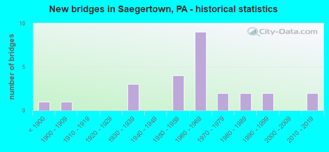
- New bridges - historical statistics
- 1Before 1900
- 11900-1909
- 31930-1939
- 41950-1959
- 91960-1969
- 21970-1979
- 21980-1989
- 21990-1999
- 22010-2019

- Reconstructed bridges - Historical Statistics
- 11970-1979
- 21980-1989
- 31990-1999
- 22000-2009
- 22010-2019


- Bridge Condition - Deck
- 5.3%Excellent
- 15.8%Very good
- 26.3%Good
- 31.6%Satisfactory
- 21.1%Fair

- Bridge Condition - Superstructure
- 5.3%Excellent
- 15.8%Very good
- 10.5%Good
- 15.8%Satisfactory
- 31.6%Fair
- 21.1%Poor

- Bridge Condition - Substructure
- 36.8%Good
- 26.3%Satisfactory
- 36.8%Fair

- Bridge Condition - Channel
- 5.9%Very good
- 17.6%Good
- 35.3%Satisfactory
- 29.4%Fair
- 11.8%Poor
Find on map >> Show street view
Structure Number: 3292, Location: SLATE LICK NO.2 (Lat: 40.757608, Lng: -79.643128), Route carried "on" structure: State highway 128, Year Built: 1971, Year Reconstructed: 2001, Status: Open, Structure Length: 9.75m (31.99ft), Average Daily Traffic: 1,177 (year 2022), Truck Traffic: 4%, Average Future Daily Traffic: 2,010 (year 2032), Design Load: HS 25 or greater, Features Intersected: SR0028 NB&SB
Minimum Vertical Clearance: 30+ m (98+ ft), Kilometerpoint: 11.307, Lanes on structure: 3, Lanes under structure: 4, Owner: State Highway Agency, Approaching Roadway Width: 14.0m (45.9ft), Skew: 3 degrees, Material/Design: Steel continuous, Design/Construction: Stringer/Multi-beam, Number Of Spans In Main Unit: 2, Number Of Approach Spans: 2, Length of Maximum Span: 36.6m (120.1ft), Curb or Sidewalk Widths: Left: 0.2m (0.7ft), Right: 0.2m (0.7ft), Curb-To-Curb Width: 14.0m (45.9ft), Out-to-Out Width: 14.9m (48.9ft)
Condition: Deck: Very good, Superstructure: Very good, Substructure: Good, Operating Rating: 73.5 metric tons, Method Used To Determine Operating Rating: Load Factor (LF), Inventory Rating: 43.5 metric tons, Method Used To Determine Inventory Rating: Load Factor (LF), Structural Evaluation: Better than present minimum criteria, Deck Geometry: Somewhat better than minimum adequacy, Underclear: Meets minimum limits, Approach Roadway Alignment: Equal to present desirable criteria, Length Of Structure Improvement: 11.40m (37.40ft), Designated Inspection Frequency: Every 24 months, Inspection Date: January 2021, Deck Structure Type: Concrete Cast-file-Place, Wearing Surface/Protective System: Wearing Surface: Monolithic Concrete, Deck Protection: Epoxy Coated Reinforcing
Find on map >> Show street view
Structure Number: 3349, Location: 225' East of SR 68 (Lat: 40.996856, Lng: -79.630392), Route carried "on" structure: City street , Year Built: 1930, Status: Open, Structure Length: 0.98m (3.22ft), Average Daily Traffic: 50 (year 2006), Truck Traffic: 9%, Average Future Daily Traffic: 70 (year 2026), Features Intersected: SUGAR CREEK, Facility Carried by Structure: T-427 CEMETERY RD
Minimum Vertical Clearance: 30+ m (98+ ft), Kilometerpoint: 0.000, Lanes on structure: 1, Owner: Town or Township Highway Agency, Approaching Roadway Width: 4.0m (13.1ft), Material/Design: Steel, Design/Construction: Stringer/Multi-beam, Number Of Spans In Main Unit: 1, Length of Maximum Span: 9.1m (29.9ft), Curb-To-Curb Width: 4.7m (15.4ft), Out-to-Out Width: 4.9m (16.1ft)
Condition: Deck: Satisfactory, Superstructure: Satisfactory, Substructure: Fair, Channel: Satisfactory, Operating Rating: 86.2 metric tons, Method Used To Determine Operating Rating: Load Factor (LF), Inventory Rating: 51.7 metric tons, Method Used To Determine Inventory Rating: Load Factor (LF), Structural Evaluation: Somewhat better than minimum adequacy, Deck Geometry: Better than present minimum criteria, Waterway Adequacy: Better than present minimum criteria, Approach Roadway Alignment: Equal to present desirable criteria, Length Of Structure Improvement: 1.60m (5.25ft), Designated Inspection Frequency: Every 24 months, Inspection Date: May 2021, Bridge Improvement Cost: $9,000, Roadway Improvement Cost: $25,000, Total Project Cost: $117,000, Deck Structure Type: Open Grating
Find on map >> Show street view
Structure Number: 3353, Location: 200 feet south of SR 0085 (Lat: 40.793997, Lng: -79.292969), Route carried "on" structure: City street , Year Built: 1988, Status: Open, Structure Length: 2.13m (6.99ft), Average Daily Traffic: 300 (year 2006), Truck Traffic: 9%, Average Future Daily Traffic: 420 (year 2026), Design Load: HS 25 or greater, Features Intersected: COWANSHANNOCK CREEK, Facility Carried by Structure: T-690 WHITE OAK RD
Minimum Vertical Clearance: 30+ m (98+ ft), Kilometerpoint: 0.000, Lanes on structure: 2, Owner: County Highway Agency, Approaching Roadway Width: 8.5m (27.9ft), Material/Design: Prestressed concrete, Design/Construction: Box Beam or Girders - Single/Spread, Number Of Spans In Main Unit: 1, Length of Maximum Span: 20.1m (65.9ft), Curb or Sidewalk Widths: Left: 0.2m (0.7ft), Right: 0.2m (0.7ft), Curb-To-Curb Width: 8.5m (27.9ft), Out-to-Out Width: 9.6m (31.5ft)
Condition: Deck: Good, Superstructure: Satisfactory, Substructure: Good, Channel: Good, Operating Rating: 54.4 metric tons, Method Used To Determine Operating Rating: Load Factor (LF), Inventory Rating: 32.7 metric tons, Method Used To Determine Inventory Rating: Load Factor (LF), Structural Evaluation: Equal to present minimum criteria, Deck Geometry: Equal to present minimum criteria, Waterway Adequacy: Better than present minimum criteria, Approach Roadway Alignment: Equal to present desirable criteria, Length Of Structure Improvement: 2.80m (9.19ft), Designated Inspection Frequency: Every 24 months, Inspection Date: Febuary 2021, Deck Structure Type: Concrete Cast-file-Place, Wearing Surface/Protective System: Wearing Surface: Monolithic Concrete, Deck Protection: Epoxy Coated Reinforcing
Find on map >> Show street view
Structure Number: 12892, Location: WOODCOCK TOWNSHIP (Lat: 41.693200, Lng: -80.157706), Route carried "on" structure: US 6, Year Built: 1937, Year Reconstructed: 1983, Status: Open, Structure Length: 9.14m (29.99ft), Average Daily Traffic: 5,439 (year 2021), Truck Traffic: 6%, Average Future Daily Traffic: 9,429 (year 2032), Design Load: H 20, Features Intersected: OVER FRENCH CREEK
Minimum Vertical Clearance: 4.37m (14.34ft), Kilometerpoint: 44.057, Lanes on structure: 2, Base Highway Network: Yes, Owner: State Highway Agency, Approaching Roadway Width: 9.8m (32.2ft), Skew: 1 degrees, Material/Design: Steel, Design/Construction: Truss - Thru, Number Of Spans In Main Unit: 2, Length of Maximum Span: 45.4m (149.0ft), Curb-To-Curb Width: 10.6m (34.8ft), Out-to-Out Width: 11.0m (36.1ft)
Condition: Deck: Fair, Superstructure: Poor, Substructure: Fair, Channel: Satisfactory, Operating Rating: 57.2 metric tons, Method Used To Determine Operating Rating: Load Factor (LF), Inventory Rating: 30.8 metric tons, Method Used To Determine Inventory Rating: Load Factor (LF), Structural Evaluation: Meets minimum limits, Deck Geometry: Meets minimum limits, Waterway Adequacy: Superior to present desirable criteria, Approach Roadway Alignment: Equal to present desirable criteria, Length Of Structure Improvement: 9.10m (29.86ft), Designated Inspection Frequency: Every 24 months, Critical Feature Inspection Frequency: Every 12 months, Underwater Inspection Frequency: Every 24 months, Other Special Inspection Frequency: Every 12 months, Inspection Date: May 2021, Critical Feature Inspection Date: May 2021, Underwater Inspection Date: October 2021, Other Special Inspection Date: May 2021, Bridge Improvement Cost: $27,000, Roadway Improvement Cost: $79,000, Total Project Cost: $363,000, Deck Structure Type: Concrete Cast-file-Place, Wearing Surface/Protective System: Wearing Surface: Monolithic Concrete, Deck Protection: Epoxy Coated Reinforcing
Find on map >> Show street view
Structure Number: 12893, Location: WOODCOCK TOWNSHIP (Lat: 41.707636, Lng: -80.145975), Route carried "on" structure: US 6, Year Built: 1936, Year Reconstructed: 1980, Status: Open, Structure Length: 9.14m (29.99ft), Average Daily Traffic: 5,439 (year 2021), Truck Traffic: 6%, Average Future Daily Traffic: 9,429 (year 2032), Design Load: HS 20, Features Intersected: OVER FRENCH CREEK
Minimum Vertical Clearance: 4.37m (14.34ft), Kilometerpoint: 46.127, Lanes on structure: 2, Base Highway Network: Yes, Owner: State Highway Agency, Approaching Roadway Width: 6.1m (20.0ft), Skew: 3 degrees, Material/Design: Steel, Design/Construction: Truss - Thru, Number Of Spans In Main Unit: 2, Length of Maximum Span: 45.4m (149.0ft), Curb or Sidewalk Widths: Left: 0.0m, Right: 2.5m (8.2ft), Curb-To-Curb Width: 9.3m (30.5ft), Out-to-Out Width: 10.4m (34.1ft)
Condition: Deck: Fair, Superstructure: Poor, Substructure: Fair, Channel: Fair, Operating Rating: 48.1 metric tons, Method Used To Determine Operating Rating: Load Factor (LF), Inventory Rating: 26.3 metric tons, Method Used To Determine Inventory Rating: Load Factor (LF), Structural Evaluation: Meets minimum limits, Deck Geometry: Meets minimum limits, Waterway Adequacy: Equal to present minimum criteria, Approach Roadway Alignment: Equal to present minimum criteria, Length Of Structure Improvement: 9.10m (29.86ft), Designated Inspection Frequency: Every 24 months, Critical Feature Inspection Frequency: Every 12 months, Underwater Inspection Frequency: Every 24 months, Other Special Inspection Frequency: Every 12 months, Inspection Date: May 2021, Critical Feature Inspection Date: May 2021, Underwater Inspection Date: May 2020, Other Special Inspection Date: May 2021, Bridge Improvement Cost: $67,000, Roadway Improvement Cost: $197,000, Total Project Cost: $905,000, Deck Structure Type: Concrete Cast-file-Place, Wearing Surface/Protective System: Wearing Surface: Monolithic Concrete, Deck Protection: Epoxy Coated Reinforcing
Find on map >> Show street view
Structure Number: 12894, Location: WOODCOCK TOWNSHIP (Lat: 41.742306, Lng: -80.130325), Route carried "on" structure: US 6, Year Built: 1972, Year Reconstructed: 1980, Status: Open, Structure Length: 23.23m (76.21ft), Average Daily Traffic: 3,344 (year 2022), Truck Traffic: 6%, Average Future Daily Traffic: 5,460 (year 2032), Design Load: HS 20+Mod, Features Intersected: OVER FRENCH CREEK
Minimum Vertical Clearance: 30+ m (98+ ft), Kilometerpoint: 50.672, Lanes on structure: 2, Owner: State Highway Agency, Approaching Roadway Width: 9.4m (30.8ft), Material/Design: Prestressed concrete, Design/Construction: Stringer/Multi-beam, Number Of Spans In Main Unit: 7, Length of Maximum Span: 32.9m (107.9ft), Curb or Sidewalk Widths: Left: 0.2m (0.7ft), Right: 0.2m (0.7ft), Curb-To-Curb Width: 13.4m (44.0ft), Out-to-Out Width: 14.9m (48.9ft)
Condition: Deck: Satisfactory, Superstructure: Satisfactory, Substructure: Satisfactory, Channel: Satisfactory, Inventory Rating: 10.9 metric tons, Method Used To Determine Inventory Rating: Load Factor (LF), Structural Evaluation: High priority of corrective action, Deck Geometry: Better than present minimum criteria, Waterway Adequacy: Equal to present desirable criteria, Approach Roadway Alignment: Equal to present desirable criteria, Length Of Structure Improvement: 23.70m (77.76ft), Designated Inspection Frequency: Every 24 months, Inspection Date: August 2020, Deck Structure Type: Concrete Cast-file-Place, Wearing Surface/Protective System: Wearing Surface: Bituminous, Membrane: Other
Find on map >> Show street view
Structure Number: 13013, Location: HAYFIELD TOWNSHIP (Lat: 41.716178, Lng: -80.200958), Route carried "on" structure: Interstate 79, Year Built: 1969, Status: Open, Structure Length: 3.32m (10.89ft), Average Daily Traffic: 9,193 (year 2021), Truck Traffic: 15%, Average Future Daily Traffic: 11,433 (year 2032), Design Load: HS 20+Mod, Features Intersected: OVER SR 198,RESERVOIR RD
Minimum Vertical Clearance: 30+ m (98+ ft), Kilometerpoint: 27.483, Lanes on structure: 2, Lanes under structure: 2, Base Highway Network: Yes, Owner: State Highway Agency, Approaching Roadway Width: 11.6m (38.1ft), Skew: 10 degrees, Material/Design: Prestressed concrete, Design/Construction: Box Beam or Girders - Single/Spread, Number Of Spans In Main Unit: 3, Length of Maximum Span: 13.4m (44.0ft), Curb or Sidewalk Widths: Left: 0.2m (0.7ft), Right: 0.2m (0.7ft), Curb-To-Curb Width: 11.7m (38.4ft), Out-to-Out Width: 13.0m (42.7ft)
Condition: Deck: Satisfactory, Superstructure: Fair, Substructure: Satisfactory, Operating Rating: 51.7 metric tons, Method Used To Determine Operating Rating: Load Factor (LF), Inventory Rating: 30.8 metric tons, Method Used To Determine Inventory Rating: Load Factor (LF), Structural Evaluation: Somewhat better than minimum adequacy, Deck Geometry: Equal to present minimum criteria, Underclear: Meets minimum limits, Approach Roadway Alignment: Equal to present desirable criteria, Length Of Structure Improvement: 4.10m (13.45ft), Designated Inspection Frequency: Every 24 months, Inspection Date: March 2021, Deck Structure Type: Concrete Cast-file-Place, Wearing Surface/Protective System: Wearing Surface: Bituminous, Membrane: Preformed Fabric
Find on map >> Show street view
Structure Number: 13015, Location: HAYFIELD TOWNSHIP (Lat: 41.736667, Lng: -80.198333), Route carried "on" structure: State highway , Year Built: 1969, Status: Open, Structure Length: 10.45m (34.28ft), Average Daily Traffic: 89 (year 2017), Truck Traffic: 10%, Average Future Daily Traffic: 107 (year 2032), Design Load: HS 20, Features Intersected: OVER SR 79 NB/SB, Facility Carried by Structure: SR 1101,MAPLE DR
Minimum Vertical Clearance: 30+ m (98+ ft), Kilometerpoint: 0.000, Lanes on structure: 2, Lanes under structure: 8, Owner: State Highway Agency, Approaching Roadway Width: 5.5m (18.0ft), Material/Design: Prestressed concrete, Design/Construction: Box Beam or Girders - Single/Spread, Number Of Spans In Main Unit: 6, Length of Maximum Span: 18.9m (62.0ft), Curb or Sidewalk Widths: Left: 0.5m (1.6ft), Right: 0.5m (1.6ft), Curb-To-Curb Width: 8.5m (27.9ft), Out-to-Out Width: 10.2m (33.5ft)
Condition: Deck: Satisfactory, Superstructure: Fair, Substructure: Good, Operating Rating: 76.2 metric tons, Method Used To Determine Operating Rating: Load Factor (LF), Inventory Rating: 34.5 metric tons, Method Used To Determine Inventory Rating: Load Factor (LF), Structural Evaluation: Somewhat better than minimum adequacy, Deck Geometry: Better than present minimum criteria, Underclear: Equal to present desirable criteria, Approach Roadway Alignment: Better than present minimum criteria, Length Of Structure Improvement: 11.50m (37.73ft), Designated Inspection Frequency: Every 24 months, Inspection Date: May 2021, Deck Structure Type: Concrete Cast-file-Place, Wearing Surface/Protective System: Wearing Surface: Bituminous, Membrane: Other
Find on map >> Show street view
Structure Number: 13016, Location: CUSSEWAGO TOWNSHIP (Lat: 41.765347, Lng: -80.194031), Route carried "on" structure: Interstate 79, Year Built: 1968, Year Reconstructed: 1996, Status: Open, Structure Length: 2.99m (9.81ft), Average Daily Traffic: 9,368 (year 2021), Truck Traffic: 15%, Average Future Daily Traffic: 10,671 (year 2032), Design Load: HS 20+Mod, Features Intersected: OVER SR 4011,MOSIERTOWN
Minimum Vertical Clearance: 30+ m (98+ ft), Kilometerpoint: 33.899, Lanes on structure: 2, Lanes under structure: 2, Base Highway Network: Yes, Owner: State Highway Agency, Approaching Roadway Width: 11.6m (38.1ft), Skew: 10 degrees, Material/Design: Prestressed concrete, Design/Construction: Box Beam or Girders - Single/Spread, Number Of Spans In Main Unit: 3, Length of Maximum Span: 10.7m (35.1ft), Curb-To-Curb Width: 11.6m (38.1ft), Out-to-Out Width: 13.0m (42.7ft)
Condition: Deck: Fair, Superstructure: Fair, Substructure: Satisfactory, Operating Rating: 44.5 metric tons, Method Used To Determine Operating Rating: Load Factor (LF), Inventory Rating: 26.3 metric tons, Method Used To Determine Inventory Rating: Load Factor (LF), Structural Evaluation: Somewhat better than minimum adequacy, Deck Geometry: Equal to present minimum criteria, Underclear: Equal to present minimum criteria, Approach Roadway Alignment: Equal to present desirable criteria, Length Of Structure Improvement: 3.00m (9.84ft), Designated Inspection Frequency: Every 24 months, Inspection Date: September 2020, Bridge Improvement Cost: $12,000, Roadway Improvement Cost: $36,000, Total Project Cost: $165,000, Deck Structure Type: Concrete Cast-file-Place, Wearing Surface/Protective System: Wearing Surface: Bituminous, Membrane: Preformed Fabric
Find on map >> Show street view
Structure Number: 13026, Location: WOODCOCK TOWNSHIP (Lat: 41.697150, Lng: -80.115681), Route carried "on" structure: State highway 86, Year Built: 1992, Status: Open, Structure Length: 2.38m (7.81ft), Average Daily Traffic: 5,953 (year 2022), Truck Traffic: 4%, Average Future Daily Traffic: 5,498 (year 2032), Design Load: HS 25 or greater, Features Intersected: OVER WOODCOCK CREEK
Minimum Vertical Clearance: 30+ m (98+ ft), Kilometerpoint: 6.252, Lanes on structure: 2, Owner: State Highway Agency, Approaching Roadway Width: 12.2m (40.0ft), Material/Design: Prestressed concrete, Design/Construction: Box Beam or Girders - Multiple, Number Of Spans In Main Unit: 1, Length of Maximum Span: 23.5m (77.1ft), Curb or Sidewalk Widths: Left: 0.2m (0.7ft), Right: 0.2m (0.7ft), Curb-To-Curb Width: 12.6m (41.3ft), Out-to-Out Width: 13.6m (44.6ft)
Condition: Deck: Good, Superstructure: Good, Substructure: Satisfactory, Channel: Very good, Operating Rating: 89.8 metric tons, Method Used To Determine Operating Rating: Load Factor (LF), Inventory Rating: 40.8 metric tons, Method Used To Determine Inventory Rating: Load Factor (LF), Structural Evaluation: Equal to present minimum criteria, Deck Geometry: Somewhat better than minimum adequacy, Waterway Adequacy: Equal to present desirable criteria, Approach Roadway Alignment: Equal to present minimum criteria, Length Of Structure Improvement: 3.10m (10.17ft), Designated Inspection Frequency: Every 24 months, Inspection Date: June 2020, Deck Structure Type: Concrete Cast-file-Place, Wearing Surface/Protective System: Wearing Surface: Bituminous, Membrane: Preformed Fabric, Deck Protection: Epoxy Coated Reinforcing
Find on map >> Show street view
Structure Number: 13073, Location: HAYFIELD TOWNSHIP (Lat: 41.724653, Lng: -80.152039), Route carried "on" structure: State highway 198, Year Built: 1953, Year Reconstructed: 2012, Status: Open, Structure Length: 1.13m (3.71ft), Average Daily Traffic: 4,041 (year 2020), Truck Traffic: 8%, Average Future Daily Traffic: 4,486 (year 2032), Design Load: HL 93, Features Intersected: OVER WOLF RUN
Minimum Vertical Clearance: 30+ m (98+ ft), Kilometerpoint: 31.701, Lanes on structure: 2, Base Highway Network: Yes, Owner: State Highway Agency, Approaching Roadway Width: 10.4m (34.1ft), Material/Design: Prestressed concrete, Design/Construction: Box Beam or Girders - Single/Spread, Number Of Spans In Main Unit: 1, Length of Maximum Span: 11.0m (36.1ft), Curb-To-Curb Width: 9.8m (32.2ft), Out-to-Out Width: 10.7m (35.1ft)
Condition: Deck: Good, Superstructure: Very good, Substructure: Good, Channel: Fair, Operating Rating: 53.1 metric tons, Method Used To Determine Operating Rating: Assigned ratings based on Load and Resistance Factor Design (LRFD) reported by rating factor (RF) using HL93 loadings, Inventory Rating: 33.4 metric tons, Method Used To Determine Inventory Rating: Assigned ratings based on Load and Resistance Factor Design (LRFD) reported by rating factor (RF) using HL93 loadings, Structural Evaluation: Better than present minimum criteria, Deck Geometry: Meets minimum limits, Waterway Adequacy: Equal to present minimum criteria, Approach Roadway Alignment: Equal to present desirable criteria, Length Of Structure Improvement: 1.71m (5.61ft), Designated Inspection Frequency: Every 48 months, Inspection Date: March 2020, Bridge Improvement Cost: $20,000, Roadway Improvement Cost: $59,000, Total Project Cost: $271,000, Wearing Surface/Protective System: Wearing Surface: Bituminous, Membrane: Preformed Fabric
Find on map >> Show street view
Structure Number: 13074, Location: SAEGERTOWN BOROUGH (Lat: 41.724528, Lng: -80.150136), Route carried "on" structure: State highway 198, Year Built: 1953, Year Reconstructed: 2017, Status: Open, Structure Length: 9.17m (30.09ft), Average Daily Traffic: 4,041 (year 2020), Truck Traffic: 8%, Average Future Daily Traffic: 4,486 (year 2032), Design Load: HL 93, Features Intersected: OVER FRENCH CREEK
Minimum Vertical Clearance: 30+ m (98+ ft), Kilometerpoint: 31.701, Lanes on structure: 2, Base Highway Network: Yes, Owner: State Highway Agency, Approaching Roadway Width: 9.8m (32.2ft), Material/Design: Steel continuous, Design/Construction: Stringer/Multi-beam, Number Of Spans In Main Unit: 3, Length of Maximum Span: 34.1m (111.9ft), Curb-To-Curb Width: 9.8m (32.2ft), Out-to-Out Width: 10.4m (34.1ft)
Condition: Deck: Excellent, Superstructure: Excellent, Substructure: Good, Channel: Satisfactory, Operating Rating: 42.4 metric tons, Method Used To Determine Operating Rating: Assigned ratings based on Load and Resistance Factor Design (LRFD) reported by rating factor (RF) using HL93 loadings, Inventory Rating: 32.7 metric tons, Method Used To Determine Inventory Rating: Assigned ratings based on Load and Resistance Factor Design (LRFD) reported by rating factor (RF) using HL93 loadings, Structural Evaluation: Better than present minimum criteria, Deck Geometry: Meets minimum limits, Waterway Adequacy: Equal to present desirable criteria, Approach Roadway Alignment: Equal to present desirable criteria, Length Of Structure Improvement: 9.20m (30.18ft), Designated Inspection Frequency: Every 24 months, Inspection Date: August 2020, Bridge Improvement Cost: $40,000, Roadway Improvement Cost: $119,000, Total Project Cost: $543,000, Deck Structure Type: Concrete Cast-file-Place, Wearing Surface/Protective System: Wearing Surface: Epoxy Overlay
Find on map >> Show street view
Structure Number: 13135, Location: SAEGERTOWN BOROUGH (Lat: 41.710206, Lng: -80.138989), Route carried "on" structure: State highway , Year Built: 1958, Year Reconstructed: 2012, Status: Open, Structure Length: 2.65m (8.69ft), Average Daily Traffic: 723 (year 2022), Truck Traffic: 2%, Average Future Daily Traffic: 1,162 (year 2032), Design Load: HS 20, Features Intersected: OVER WOODCOCK CREEK, Facility Carried by Structure: SR 1001,PARK AVE.
Minimum Vertical Clearance: 30+ m (98+ ft), Kilometerpoint: 9.246, Lanes on structure: 2, Owner: State Highway Agency, Approaching Roadway Width: 6.7m (22.0ft), Skew: 3 degrees, Material/Design: Prestressed concrete, Design/Construction: Box Beam or Girders - Single/Spread, Number Of Spans In Main Unit: 2, Length of Maximum Span: 13.1m (43.0ft), Curb or Sidewalk Widths: Left: 0.1m (0.3ft), Right: 0.1m (0.3ft), Curb-To-Curb Width: 8.8m (28.9ft), Out-to-Out Width: 9.2m (30.2ft)
Condition: Deck: Very good, Superstructure: Very good, Substructure: Good, Channel: Satisfactory, Operating Rating: 52.6 metric tons, Method Used To Determine Operating Rating: Load and Resistance Factor (LRFR), Inventory Rating: 39.9 metric tons, Method Used To Determine Inventory Rating: Load and Resistance Factor (LRFR), Structural Evaluation: Better than present minimum criteria, Deck Geometry: Somewhat better than minimum adequacy, Waterway Adequacy: Equal to present desirable criteria, Approach Roadway Alignment: Equal to present desirable criteria, Length Of Structure Improvement: 2.50m (8.20ft), Designated Inspection Frequency: Every 24 months, Inspection Date: September 2021, Bridge Improvement Cost: $22,000, Roadway Improvement Cost: $66,000, Total Project Cost: $302,000, Wearing Surface/Protective System: Wearing Surface: Monolithic Concrete, Deck Protection: Epoxy Coated Reinforcing
Find on map >> Show street view
Structure Number: 13171, Location: CUSSEWAGO TOWNSHIP (Lat: 41.770683, Lng: -80.178942), Route carried "on" structure: State highway , Year Built: 1951, Status: Open, Structure Length: 0.70m (2.30ft), Average Daily Traffic: 409 (year 2017), Truck Traffic: 4%, Average Future Daily Traffic: 503 (year 2032), Design Load: H 20, Features Intersected: OVER HOTCH KISS RUN, Facility Carried by Structure: SR 1015,GSPL. HILL
Minimum Vertical Clearance: 30+ m (98+ ft), Kilometerpoint: 1.064, Lanes on structure: 2, Owner: State Highway Agency, Approaching Roadway Width: 4.6m (15.1ft), Skew: 1 degrees, Material/Design: Steel, Design/Construction: Stringer/Multi-beam, Number Of Spans In Main Unit: 1, Length of Maximum Span: 6.4m (21.0ft), Curb or Sidewalk Widths: Left: 0.2m (0.7ft), Right: 0.2m (0.7ft), Curb-To-Curb Width: 6.7m (22.0ft), Out-to-Out Width: 7.5m (24.6ft)
Condition: Deck: Fair, Superstructure: Fair, Substructure: Fair, Channel: Fair, Operating Rating: 64.4 metric tons, Method Used To Determine Operating Rating: Load Factor (LF), Inventory Rating: 38.1 metric tons, Method Used To Determine Inventory Rating: Load Factor (LF), Structural Evaluation: Somewhat better than minimum adequacy, Deck Geometry: Meets minimum limits, Waterway Adequacy: Equal to present desirable criteria, Approach Roadway Alignment: Equal to present desirable criteria, Length Of Structure Improvement: 1.30m (4.27ft), Designated Inspection Frequency: Every 24 months, Inspection Date: May 2020, Bridge Improvement Cost: $3,000, Roadway Improvement Cost: $9,000, Total Project Cost: $43,000, Deck Structure Type: Closed Grating, Wearing Surface/Protective System: Wearing Surface: Bituminous
Find on map >> Show street view
Structure Number: 13513, Location: JUST SOUTH OF SAEGERTOWN (Lat: 41.702500, Lng: -80.125797), Route carried "on" structure: City street 7235, Year Built: 1896, Year Reconstructed: 2019, Status: Posted for load, Structure Length: 2.44m (8.01ft), Average Daily Traffic: 250 (year 2020), Truck Traffic: 1%, Average Future Daily Traffic: 350 (year 2040), Design Load: H 15, Features Intersected: OVER WOODCOCK CREEK, Facility Carried by Structure: T-600,CRAIG ROAD
Minimum Vertical Clearance: 3.66m (12.01ft), Kilometerpoint: 0.000, Lanes on structure: 1, Owner: County Highway Agency, Approaching Roadway Width: 4.9m (16.1ft), Material/Design: Steel, Design/Construction: Truss - Thru, Number Of Spans In Main Unit: 1, Length of Maximum Span: 22.6m (74.1ft), Curb or Sidewalk Widths: Left: 0.2m (0.7ft), Right: 0.2m (0.7ft), Curb-To-Curb Width: 4.6m (15.1ft), Out-to-Out Width: 4.8m (15.7ft)
Condition: Deck: Very good, Superstructure: Fair, Substructure: Fair, Channel: Fair, Operating Rating: 13.6 metric tons, Method Used To Determine Operating Rating: Allowable Stress (AS), Inventory Rating: 9.1 metric tons, Method Used To Determine Inventory Rating: Allowable Stress (AS), Structural Evaluation: High priority of replacement, Deck Geometry: High priority of replacement, Waterway Adequacy: Equal to present desirable criteria, Approach Roadway Alignment: Somewhat better than minimum adequacy, Bridge Posting: Required (Relationship of Operating Rating to Maximum Legal Load: > 39.9% below), Length Of Structure Improvement: 3.00m (9.84ft), Designated Inspection Frequency: Every 24 months, Critical Feature Inspection Frequency: Every 12 months, Other Special Inspection Frequency: Every 12 months, Inspection Date: April 2020, Critical Feature Inspection Date: April 2021, Other Special Inspection Date: April 2021, Bridge Improvement Cost: $60,000, Roadway Improvement Cost: $264,000, Total Project Cost: $807,000, Deck Structure Type: Wood or Timber, Wearing Surface/Protective System: Wearing Surface: Wood or Timber
Find on map >> Show street view
Structure Number: 13518, Location: GERMAN ROAD,T-657 (Lat: 41.695689, Lng: -80.113283), Route carried "on" structure: City street 7235, Year Built: 1989, Status: Open, Structure Length: 0.79m (2.59ft), Average Daily Traffic: 250 (year 2020), Truck Traffic: 1%, Average Future Daily Traffic: 350 (year 2040), Design Load: HS 25 or greater, Features Intersected: OVER WOODCOCK CREEK TR., Facility Carried by Structure: T-657,GERMAN ROAD
Minimum Vertical Clearance: 30+ m (98+ ft), Kilometerpoint: 0.000, Lanes on structure: 2, Owner: Town or Township Highway Agency, Approaching Roadway Width: 5.5m (18.0ft), Skew: 3 degrees, Material/Design: Wood or Timber, Design/Construction: Stringer/Multi-beam, Number Of Spans In Main Unit: 1, Length of Maximum Span: 7.6m (24.9ft), Curb or Sidewalk Widths: Left: 0.1m (0.3ft), Right: 0.1m (0.3ft), Curb-To-Curb Width: 6.7m (22.0ft), Out-to-Out Width: 7.7m (25.3ft)
Condition: Deck: Good, Superstructure: Fair, Substructure: Fair, Channel: Poor, Operating Rating: 97.1 metric tons, Method Used To Determine Operating Rating: Allowable Stress (AS), Inventory Rating: 72.6 metric tons, Method Used To Determine Inventory Rating: Allowable Stress (AS), Structural Evaluation: Somewhat better than minimum adequacy, Deck Geometry: Meets minimum limits, Waterway Adequacy: Equal to present minimum criteria, Approach Roadway Alignment: Equal to present desirable criteria, Length Of Structure Improvement: 1.00m (3.28ft), Designated Inspection Frequency: Every 24 months, Inspection Date: May 2020, Deck Structure Type: Wood or Timber, Wearing Surface/Protective System: Wearing Surface: Bituminous
Find on map >> Show street view
Structure Number: 13554, Location: JUST OUTSIDE SAEGERTOWN (Lat: 41.714475, Lng: -80.146842), Route carried "on" structure: City street 7409, Year Built: 1900, Year Reconstructed: 1990, Status: Posted for load, Structure Length: 6.28m (20.60ft), Average Daily Traffic: 250 (year 2021), Average Future Daily Traffic: 313 (year 2041), Design Load: H 15, Features Intersected: OVER FRENCH CREEK, Facility Carried by Structure: T-962,JORDAN DRIVE
Minimum Vertical Clearance: 2.44m (8.01ft), Kilometerpoint: 0.000, Lanes on structure: 1, Owner: County Highway Agency, Approaching Roadway Width: 5.2m (17.1ft), Material/Design: Steel, Design/Construction: Truss - Thru, Number Of Spans In Main Unit: 1, Length of Maximum Span: 61.9m (203.1ft), Curb or Sidewalk Widths: Left: 0.2m (0.7ft), Right: 0.2m (0.7ft), Curb-To-Curb Width: 4.6m (15.1ft), Out-to-Out Width: 4.9m (16.1ft)
Condition: Deck: Good, Superstructure: Poor, Substructure: Satisfactory, Channel: Satisfactory, Operating Rating: 12.7 metric tons, Method Used To Determine Operating Rating: Load Factor (LF), Inventory Rating: 7.3 metric tons, Method Used To Determine Inventory Rating: Load Factor (LF), Structural Evaluation: High priority of replacement, Deck Geometry: High priority of replacement, Waterway Adequacy: Better than present minimum criteria, Approach Roadway Alignment: Equal to present minimum criteria, Bridge Posting: Required (Relationship of Operating Rating to Maximum Legal Load: > 39.9% below), Length Of Structure Improvement: 7.80m (25.59ft), Designated Inspection Frequency: Every 24 months, Critical Feature Inspection Frequency: Every 12 months, Other Special Inspection Frequency: Every 12 months, Inspection Date: August 2021, Critical Feature Inspection Date: August 2021, Other Special Inspection Date: August 2021, Bridge Improvement Cost: $121,000, Roadway Improvement Cost: $356,000, Total Project Cost: $1,631,000, Deck Structure Type: Wood or Timber, Wearing Surface/Protective System: Wearing Surface: Wood or Timber
Find on map >> Show street view
Structure Number: 3286, Location: VILLAGE OF MORRIS (Lat: 41.595353, Lng: -77.294047), Route carried "on" structure: State highway 287, Year Built: 1991, Status: Open, Structure Length: 4.48m (14.70ft), Average Daily Traffic: 2,669 (year 2020), Truck Traffic: 22%, Average Future Daily Traffic: 4,099 (year 2032), Design Load: HS 25 or greater, Features Intersected: BABB CREEK
Minimum Vertical Clearance: 30+ m (98+ ft), Kilometerpoint: 6.466, Lanes on structure: 2, Base Highway Network: Yes, Owner: State Highway Agency, Approaching Roadway Width: 11.6m (38.1ft), Skew: 2 degrees, Material/Design: Prestressed concrete continuous, Design/Construction: Box Beam or Girders - Multiple, Number Of Spans In Main Unit: 2, Length of Maximum Span: 21.3m (69.9ft), Curb or Sidewalk Widths: Left: 0.2m (0.7ft), Right: 0.2m (0.7ft), Curb-To-Curb Width: 12.7m (41.7ft), Out-to-Out Width: 13.8m (45.3ft)
Condition: Deck: Satisfactory, Superstructure: Good, Substructure: Good, Channel: Good, Inventory Rating: 59.9 metric tons, Method Used To Determine Inventory Rating: Load Factor (LF), Structural Evaluation: Better than present minimum criteria, Deck Geometry: Equal to present minimum criteria, Waterway Adequacy: Superior to present desirable criteria, Approach Roadway Alignment: Equal to present desirable criteria, Length Of Structure Improvement: 4.50m (14.76ft), Designated Inspection Frequency: Every 48 months, Inspection Date: October 2018, Deck Structure Type: Concrete Cast-file-Place, Wearing Surface/Protective System: Wearing Surface: Epoxy Overlay, Deck Protection: Epoxy Coated Reinforcing
Find on map >> Show street view
Structure Number: 3352, Location: 1 MI W BUFFALO CROSSROADS (Lat: 40.965561, Lng: -76.988286), Route carried "on" structure: State highway , Year Built: 1960, Status: Open, Structure Length: 5.03m (16.50ft), Average Daily Traffic: 521 (year 2021), Truck Traffic: 17%, Average Future Daily Traffic: 834 (year 2032), Design Load: H 20, Features Intersected: BUFFALO CREEK, Facility Carried by Structure: SR 2001
Minimum Vertical Clearance: 30+ m (98+ ft), Kilometerpoint: 2.765, Lanes on structure: 2, Owner: State Highway Agency, Approaching Roadway Width: 5.5m (18.0ft), Skew: 1 degrees, Material/Design: Prestressed concrete, Design/Construction: Box Beam or Girders - Multiple, Number Of Spans In Main Unit: 4, Length of Maximum Span: 12.8m (42.0ft), Curb or Sidewalk Widths: Left: 0.5m (1.6ft), Right: 0.5m (1.6ft), Curb-To-Curb Width: 8.5m (27.9ft), Out-to-Out Width: 10.2m (33.5ft)
Condition: Deck: Satisfactory, Superstructure: Poor, Substructure: Fair, Channel: Poor, Operating Rating: 78.0 metric tons, Method Used To Determine Operating Rating: Load Factor (LF), Inventory Rating: 43.5 metric tons, Method Used To Determine Inventory Rating: Load Factor (LF), Structural Evaluation: Meets minimum limits, Deck Geometry: Somewhat better than minimum adequacy, Waterway Adequacy: Superior to present desirable criteria, Approach Roadway Alignment: Equal to present desirable criteria, Length Of Structure Improvement: 6.00m (19.69ft), Designated Inspection Frequency: Every 24 months, Inspection Date: Febuary 2021, Bridge Improvement Cost: $70,000, Roadway Improvement Cost: $206,000, Total Project Cost: $945,000, Deck Structure Type: Concrete Cast-file-Place, Wearing Surface/Protective System: Wearing Surface: Bituminous, Membrane: Preformed Fabric
Find on map >> Show street view
Structure Number: 53591, Location: HAYFIELD TOWNSHIP (Lat: 41.732875, Lng: -80.161589), Route carried "on" structure: State highway , Year Built: 2016, Status: Open, Structure Length: 0.82m (2.69ft), Average Daily Traffic: 1,079 (year 2017), Truck Traffic: 5%, Average Future Daily Traffic: 1,303 (year 2037), Design Load: HL 93, Features Intersected: Brookhouser Creek, Facility Carried by Structure: GRANGE CENTER RD
Minimum Vertical Clearance: 30+ m (98+ ft), Kilometerpoint: 0.962, Lanes on structure: 2, Owner: State Highway Agency, Maintenance Responsibility: Private, Approaching Roadway Width: 7.9m (25.9ft), Skew: 1 degrees, Material/Design: Concrete, Design/Construction: Culvert, Number Of Spans In Main Unit: 1, Length of Maximum Span: 7.6m (24.9ft), Curb-To-Curb Width: 7.9m (25.9ft), Out-to-Out Width: 9.6m (31.5ft)
Condition: Channel: Good, Culverts: Very good, Operating Rating: 66.7 metric tons, Method Used To Determine Operating Rating: Assigned ratings based on Load and Resistance Factor Design (LRFD) reported by rating factor (RF) using HL93 loadings, Inventory Rating: 41.8 metric tons, Method Used To Determine Inventory Rating: Assigned ratings based on Load and Resistance Factor Design (LRFD) reported by rating factor (RF) using HL93 loadings, Structural Evaluation: Equal to present desirable criteria, Deck Geometry: Meets minimum limits, Waterway Adequacy: Superior to present desirable criteria, Approach Roadway Alignment: Equal to present desirable criteria, Designated Inspection Frequency: Every 24 months, Inspection Date: April 2020, Wearing Surface/Protective System: Wearing Surface: Bituminous, Membrane: Preformed Fabric
Find on map >> Show street view
Structure Number: 56861, Location: 2.5 mi NW of Saegertown (Lat: 41.756389, Lng: -80.167917), Route carried "on" structure: City street 7206, Year Built: 2019, Status: Open, Structure Length: 0.76m (2.49ft), Average Daily Traffic: 250 (year 2021), Truck Traffic: 1%, Average Future Daily Traffic: 350 (year 2041), Design Load: HL 93, Features Intersected: WOLF RUN, Facility Carried by Structure: T-540,FRY ROAD
Minimum Vertical Clearance: 30+ m (98+ ft), Kilometerpoint: 0.000, Lanes on structure: 2, Owner: Town or Township Highway Agency, Approaching Roadway Width: 4.9m (16.1ft), Skew: 1 degrees, Material/Design: Aluminum, Iron, Design/Construction: Culvert, Number Of Spans In Main Unit: 1, Length of Maximum Span: 7.6m (24.9ft)
Condition: Channel: Fair, Culverts: Very good, Operating Rating: 48.6 metric tons, Method Used To Determine Operating Rating: Assigned ratings based on Load and Resistance Factor Design (LRFD) reported by rating factor (RF) using HL93 loadings, Inventory Rating: 32.4 metric tons, Method Used To Determine Inventory Rating: Assigned ratings based on Load and Resistance Factor Design (LRFD) reported by rating factor (RF) using HL93 loadings, Structural Evaluation: Equal to present desirable criteria, Waterway Adequacy: Better than present minimum criteria, Approach Roadway Alignment: Equal to present desirable criteria, Designated Inspection Frequency: Every 24 months, Inspection Date: May 2021
Find on map >> Show street view
Structure Number: 13012, Location: HAYFIELD TOWNSHIP (Lat: 41.716161, Lng: -80.200467), Route carried "under" structure: State highway 198, Year Built: 1969, Structure Length: 0. m, Average Daily Traffic: 4,041 (year 2020), Truck Traffic: 8%, Features Intersected: OVER SR 198,RESERVOIR RD, Facility Carried by Structure: SR 79,NB
Minimum Vertical Clearance: 4.54m (14.90ft), Kilometerpoint: 27.636, Lanes on structure: 2, Lanes under structure: 2, Material/Design: Prestressed concrete, Design/Construction: Box Beam or Girders - Single/Spread, Length of Maximum Span: 13.4m (44.0ft)
Find on map >> Show street view
Structure Number: 13013, Location: HAYFIELD TOWNSHIP (Lat: 41.716178, Lng: -80.200958), Route carried "under" structure: State highway 198, Year Built: 1969, Structure Length: 0. m, Average Daily Traffic: 4,041 (year 2020), Truck Traffic: 8%, Features Intersected: OVER SR 198,RESERVOIR RD, Facility Carried by Structure: SR 79,SB
Minimum Vertical Clearance: 30+ m (98+ ft), Kilometerpoint: 27.636, Lanes on structure: 2, Lanes under structure: 2, Material/Design: Prestressed concrete, Design/Construction: Box Beam or Girders - Single/Spread, Length of Maximum Span: 13.4m (44.0ft)
Find on map >> Show street view
Structure Number: 13015, Location: HAYFIELD TOWNSHIP (Lat: 41.736667, Lng: -80.198333), Route carried "under" structure: Interstate 79, Year Built: 1969, Structure Length: 0. m, Average Daily Traffic: 9,193 (year 2021), Truck Traffic: 15%, Features Intersected: OVER SR 79 NB/SB, Facility Carried by Structure: SR 1101,MAPLE DR
Minimum Vertical Clearance: 5.28m (17.32ft), Kilometerpoint: 31.496, Lanes on structure: 2, Lanes under structure: 4, Material/Design: Prestressed concrete, Design/Construction: Box Beam or Girders - Single/Spread, Length of Maximum Span: 18.9m (62.0ft)
Find on map >> Show street view
Structure Number: 13015, Location: HAYFIELD TOWNSHIP (Lat: 41.736667, Lng: -80.198333), Route carried "under" structure: Interstate 79, Year Built: 1969, Structure Length: 0. m, Average Daily Traffic: 9,368 (year 2021), Truck Traffic: 15%, Features Intersected: OVER SR 79 NB/SB, Facility Carried by Structure: SR 1101,MAPLE DR
Minimum Vertical Clearance: 5.31m (17.42ft), Kilometerpoint: 31.516, Lanes on structure: 2, Lanes under structure: 4, Material/Design: Prestressed concrete, Design/Construction: Box Beam or Girders - Single/Spread, Length of Maximum Span: 18.9m (62.0ft)
Find on map >> Show street view
Structure Number: 13016, Location: CUSSEWAGO TOWNSHIP (Lat: 41.765347, Lng: -80.194031), Route carried "under" structure: State highway , Year Built: 1968, Structure Length: 0. m, Average Daily Traffic: 1,079 (year 2017), Truck Traffic: 5%, Features Intersected: OVER SR 4011,MOSIERTOWN, Facility Carried by Structure: SR 79,NB
Minimum Vertical Clearance: 4.55m (14.93ft), Kilometerpoint: 5.670, Lanes on structure: 2, Lanes under structure: 2, Material/Design: Prestressed concrete, Design/Construction: Box Beam or Girders - Single/Spread, Length of Maximum Span: 10.7m (35.1ft)