Bridge Statistics for Rutland, Illinois (IL)
Condition, Traffic, Stress, Structural Evaluation, Project Costs
- National Bridge Inventory (NBI) Statistics
- 12Number of bridges
- 92ft / 28.1mTotal length
- 54,845Total average daily traffic
- 18,986Total average daily truck traffic
- National Bridge Inventory (NBI) Registered Bridges for Rutland
- No street view available for this location
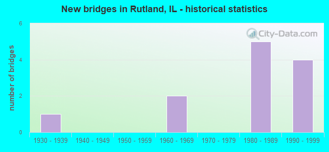
- New bridges - historical statistics
- 11930-1939
- 21960-1969
- 51980-1989
- 41990-1999


- Bridge Condition - Deck
- 37.5%Very good
- 37.5%Good
- 25.0%Fair

- Bridge Condition - Superstructure
- 25.0%Very good
- 25.0%Good
- 50.0%Fair

- Bridge Condition - Substructure
- 37.5%Very good
- 25.0%Satisfactory
- 25.0%Fair
- 12.5%Poor

- Bridge Condition - Channel
- 50.0%Very good
- 33.3%Good
- 16.7%Satisfactory
Find on map >> Show street view
Structure Number: 503112, Location: E 8TH N 250 (Lat: 40.963003, Lng: -89.008203), Route carried "on" structure: County highway , Year Built: 1932, Year Reconstructed: 1991, Status: Open, Structure Length: 0.97m (3.18ft), Average Daily Traffic: 25 (year 2016), Truck Traffic: 40%, Average Future Daily Traffic: 29 (year 2032), Design Load: HS 20, Features Intersected: LONG POINT CR, Facility Carried by Structure: TR 142B
Minimum Vertical Clearance: 30+ m (98+ ft), Kilometerpoint: 6.099, Lanes on structure: 2, Owner: Town or Township Highway Agency, Approaching Roadway Width: 5.8m (19.0ft), Skew: 3 degrees, Material/Design: Concrete, Design/Construction: Channel Beam, Number Of Spans In Main Unit: 1, Length of Maximum Span: 8.9m (29.2ft), Curb-To-Curb Width: 8.0m (26.2ft), Out-to-Out Width: 8.0m (26.2ft)
Condition: Deck: Very good, Superstructure: Very good, Substructure: Very good, Channel: Very good, Operating Rating: 76.8 metric tons, Method Used To Determine Operating Rating: Load Factor (LF) rating reported by rating factor (RF) method using MS18 loading, Inventory Rating: 46.0 metric tons, Method Used To Determine Inventory Rating: Load Factor (LF) rating reported by rating factor (RF) method using MS18 loading, Structural Evaluation: Equal to present desirable criteria, Deck Geometry: Equal to present minimum criteria, Waterway Adequacy: Better than present minimum criteria, Approach Roadway Alignment: Equal to present desirable criteria, Designated Inspection Frequency: Every 24 months, Inspection Date: June 2020, Deck Structure Type: Concrete Precast Panels, Wearing Surface/Protective System: Wearing Surface: Bituminous
Find on map >> Show street view
Structure Number: 503241, Location: N 6TH E 750 (Lat: 41.013847, Lng: -89.018367), Route carried "on" structure: County highway , Year Built: 1963, Status: Open, Structure Length: 1.14m (3.74ft), Average Daily Traffic: 10 (year 2016), Average Future Daily Traffic: 11 (year 2032), Design Load: HS 15, Features Intersected: CREEK, Facility Carried by Structure: TR 561
Minimum Vertical Clearance: 30+ m (98+ ft), Kilometerpoint: 2.446, Lanes on structure: 2, Owner: Town or Township Highway Agency, Approaching Roadway Width: 3.4m (11.2ft), Material/Design: Concrete, Design/Construction: Channel Beam, Number Of Spans In Main Unit: 1, Length of Maximum Span: 10.8m (35.4ft), Curb-To-Curb Width: 7.4m (24.3ft), Out-to-Out Width: 8.0m (26.2ft)
Condition: Deck: Good, Superstructure: Good, Substructure: Fair, Channel: Satisfactory, Operating Rating: 51.5 metric tons, Method Used To Determine Operating Rating: Load Factor (LF) rating reported by rating factor (RF) method using MS18 loading, Inventory Rating: 30.8 metric tons, Method Used To Determine Inventory Rating: Load Factor (LF) rating reported by rating factor (RF) method using MS18 loading, Structural Evaluation: Somewhat better than minimum adequacy, Deck Geometry: Equal to present minimum criteria, Waterway Adequacy: Better than present minimum criteria, Approach Roadway Alignment: Equal to present minimum criteria, Designated Inspection Frequency: Every 24 months, Inspection Date: June 2020, Deck Structure Type: Concrete Precast Panels
Find on map >> Show street view
Structure Number: 503407, Location: E 7TH N 580 (Lat: 41.010458, Lng: -89.027183), Route carried "on" structure: County highway , Year Built: 1969, Status: Open, Structure Length: 1.31m (4.30ft), Average Daily Traffic: 25 (year 2016), Truck Traffic: 40%, Average Future Daily Traffic: 28 (year 2032), Design Load: HS 15, Features Intersected: PRAIRIE CR, Facility Carried by Structure: TR 122
Minimum Vertical Clearance: 30+ m (98+ ft), Kilometerpoint: 0.354, Lanes on structure: 2, Owner: Town or Township Highway Agency, Approaching Roadway Width: 4.6m (15.1ft), Skew: 3 degrees, Material/Design: Prestressed concrete, Design/Construction: Box Beam or Girders - Multiple, Number Of Spans In Main Unit: 1, Length of Maximum Span: 12.8m (42.0ft), Curb-To-Curb Width: 7.3m (24.0ft), Out-to-Out Width: 7.9m (25.9ft)
Condition: Deck: Fair, Superstructure: Fair, Substructure: Poor, Channel: Good, Operating Rating: 32.1 metric tons, Method Used To Determine Operating Rating: Load Factor (LF) rating reported by rating factor (RF) method using MS18 loading, Inventory Rating: 19.1 metric tons, Method Used To Determine Inventory Rating: Load Factor (LF) rating reported by rating factor (RF) method using MS18 loading, Structural Evaluation: Meets minimum limits, Deck Geometry: Equal to present minimum criteria, Waterway Adequacy: Equal to present minimum criteria, Approach Roadway Alignment: Better than present minimum criteria, Bridge Posting: Required (Relationship of Operating Rating to Maximum Legal Load: 20.0 - 29.9% below), Designated Inspection Frequency: Every 24 months, Inspection Date: June 2020, Deck Structure Type: Concrete Precast Panels
Find on map >> Show street view
Structure Number: 503524, Location: N6TH RD, E 815 (Lat: 41.014133, Lng: -89.004458), Route carried "on" structure: County highway , Year Built: 1988, Status: Open, Structure Length: 1.56m (5.12ft), Average Daily Traffic: 10 (year 2016), Average Future Daily Traffic: 11 (year 2032), Design Load: HS 20, Features Intersected: DRAINAGE DITCH, Facility Carried by Structure: TR 561
Minimum Vertical Clearance: 30+ m (98+ ft), Kilometerpoint: 3.621, Lanes on structure: 2, Owner: Town or Township Highway Agency, Approaching Roadway Width: 3.7m (12.1ft), Material/Design: Prestressed concrete, Design/Construction: Box Beam or Girders - Multiple, Number Of Spans In Main Unit: 2, Length of Maximum Span: 14.9m (48.9ft), Curb-To-Curb Width: 7.3m (24.0ft), Out-to-Out Width: 7.3m (24.0ft)
Condition: Deck: Good, Superstructure: Good, Substructure: Very good, Channel: Very good, Operating Rating: 44.1 metric tons, Method Used To Determine Operating Rating: Assigned rating based on Load Factor Design (LFD) reported by rating factor (RF) using MS18 loading, Inventory Rating: 32.4 metric tons, Method Used To Determine Inventory Rating: Assigned rating based on Load Factor Design (LFD) reported by rating factor (RF) using MS18 loading, Structural Evaluation: Better than present minimum criteria, Deck Geometry: Equal to present minimum criteria, Waterway Adequacy: Equal to present desirable criteria, Approach Roadway Alignment: Equal to present desirable criteria, Designated Inspection Frequency: Every 48 months, Inspection Date: June 2018, Deck Structure Type: Concrete Precast Panels
Find on map >> Show street view
Structure Number: 50353, Location: N5TH, E670TH (Lat: 40.999028, Lng: -89.034744), Route carried "on" structure: County highway , Year Built: 1989, Status: Open, Structure Length: 1.40m (4.59ft), Average Daily Traffic: 100 (year 2020), Truck Traffic: 16%, Average Future Daily Traffic: 168 (year 2032), Design Load: HS 20, Features Intersected: STREAM, Facility Carried by Structure: TR 563
Minimum Vertical Clearance: 30+ m (98+ ft), Kilometerpoint: 1.062, Lanes on structure: 2, Owner: Town or Township Highway Agency, Approaching Roadway Width: 6.4m (21.0ft), Material/Design: Prestressed concrete, Design/Construction: Box Beam or Girders - Multiple, Number Of Spans In Main Unit: 1, Length of Maximum Span: 13.4m (44.0ft), Curb-To-Curb Width: 7.3m (24.0ft), Out-to-Out Width: 7.3m (24.0ft)
Condition: Deck: Very good, Superstructure: Very good, Substructure: Very good, Channel: Good, Operating Rating: 44.4 metric tons, Method Used To Determine Operating Rating: Assigned rating based on Load Factor Design (LFD) reported by rating factor (RF) using MS18 loading, Inventory Rating: 32.4 metric tons, Method Used To Determine Inventory Rating: Assigned rating based on Load Factor Design (LFD) reported by rating factor (RF) using MS18 loading, Structural Evaluation: Equal to present desirable criteria, Deck Geometry: Equal to present minimum criteria, Waterway Adequacy: Equal to present desirable criteria, Approach Roadway Alignment: Equal to present desirable criteria, Designated Inspection Frequency: Every 48 months, Inspection Date: June 2018, Deck Structure Type: Concrete Precast Panels, Wearing Surface/Protective System: Wearing Surface: Bituminous
Find on map >> Show street view
Structure Number: 50502, Location: E 9TH,N 6TH (Lat: 41.013997, Lng: -88.988397), Route carried "on" structure: County highway , Year Built: 1988, Status: Open, Structure Length: 0.79m (2.59ft), Average Daily Traffic: 50 (year 2020), Truck Traffic: 12%, Average Future Daily Traffic: 140 (year 2032), Design Load: HS 20, Features Intersected: CREEK, Facility Carried by Structure: TR 152A
Minimum Vertical Clearance: 30+ m (98+ ft), Kilometerpoint: 11.764, Lanes on structure: 2, Owner: Town or Township Highway Agency, Approaching Roadway Width: 9.1m (29.9ft), Material/Design: Concrete continuous, Design/Construction: Culvert, Number Of Spans In Main Unit: 2, Length of Maximum Span: 3.7m (12.1ft), Curb-To-Curb Width: 9.1m (29.9ft), Out-to-Out Width: 15.2m (49.9ft)
Condition: Channel: Very good, Culverts: Very good, Operating Rating: 44.4 metric tons, Method Used To Determine Operating Rating: Assigned rating based on Load Factor Design (LFD) reported by rating factor (RF) using MS18 loading, Inventory Rating: 32.4 metric tons, Method Used To Determine Inventory Rating: Assigned rating based on Load Factor Design (LFD) reported by rating factor (RF) using MS18 loading, Structural Evaluation: Equal to present desirable criteria, Deck Geometry: Better than present minimum criteria, Waterway Adequacy: Equal to present desirable criteria, Approach Roadway Alignment: Superior to present desirable criteria, Designated Inspection Frequency: Every 48 months, Inspection Date: June 2018
Find on map >> Show street view
Structure Number: 620053, Location: 2.02 MI S 0F ILL 17 (Lat: 40.998803, Lng: -89.054547), Route carried "on" structure: County highway , Year Built: 1989, Status: Open, Structure Length: 6.98m (22.90ft), Average Daily Traffic: 725 (year 2019), Truck Traffic: 15%, Average Future Daily Traffic: 613 (year 2032), Design Load: HS 20, Features Intersected: I-39/US 51, Facility Carried by Structure: CH 4 (500 N)
Minimum Vertical Clearance: 30+ m (98+ ft), Kilometerpoint: 6.711, Lanes on structure: 2, Lanes under structure: 4, Owner: State Highway Agency, Approaching Roadway Width: 6.7m (22.0ft), Material/Design: Steel continuous, Design/Construction: Stringer/Multi-beam, Number Of Spans In Main Unit: 3, Length of Maximum Span: 50.6m (166.0ft), Curb-To-Curb Width: 10.4m (34.1ft), Out-to-Out Width: 11.3m (37.1ft)
Condition: Deck: Fair, Superstructure: Fair, Substructure: Satisfactory, Operating Rating: 68.4 metric tons, Method Used To Determine Operating Rating: Load Factor (LF) rating reported by rating factor (RF) method using MS18 loading, Inventory Rating: 41.5 metric tons, Method Used To Determine Inventory Rating: Load Factor (LF) rating reported by rating factor (RF) method using MS18 loading, Structural Evaluation: Somewhat better than minimum adequacy, Deck Geometry: Equal to present minimum criteria, Underclear: Equal to present minimum criteria, Approach Roadway Alignment: Equal to present minimum criteria, Designated Inspection Frequency: Every 24 months, Inspection Date: March 2021, Deck Structure Type: Concrete Cast-file-Place, Wearing Surface/Protective System: Deck Protection: Epoxy Coated Reinforcing
Find on map >> Show street view
Structure Number: 620054, Location: 3 MI S OF IL 17 (Lat: 40.984269, Lng: -89.056281), Route carried "on" structure: County highway , Year Built: 1990, Status: Open, Structure Length: 6.98m (22.90ft), Average Daily Traffic: 125 (year 2019), Truck Traffic: 17%, Average Future Daily Traffic: 195 (year 2032), Design Load: HS 20, Features Intersected: I-39/US 51, Facility Carried by Structure: FAS 369 (400 N)
Minimum Vertical Clearance: 30+ m (98+ ft), Kilometerpoint: 7.306, Lanes on structure: 2, Lanes under structure: 4, Owner: State Highway Agency, Approaching Roadway Width: 6.1m (20.0ft), Material/Design: Steel continuous, Design/Construction: Stringer/Multi-beam, Number Of Spans In Main Unit: 3, Length of Maximum Span: 50.6m (166.0ft), Curb-To-Curb Width: 8.5m (27.9ft), Out-to-Out Width: 9.5m (31.2ft)
Condition: Deck: Good, Superstructure: Fair, Substructure: Satisfactory, Operating Rating: 60.3 metric tons, Method Used To Determine Operating Rating: Load Factor (LF) rating reported by rating factor (RF) method using MS18 loading, Inventory Rating: 36.0 metric tons, Method Used To Determine Inventory Rating: Load Factor (LF) rating reported by rating factor (RF) method using MS18 loading, Structural Evaluation: Somewhat better than minimum adequacy, Deck Geometry: Equal to present minimum criteria, Underclear: Somewhat better than minimum adequacy, Approach Roadway Alignment: Equal to present minimum criteria, Designated Inspection Frequency: Every 24 months, Inspection Date: March 2021, Deck Structure Type: Concrete Cast-file-Place, Wearing Surface/Protective System: Deck Protection: Epoxy Coated Reinforcing
Find on map >> Show street view
Structure Number: 620055, Location: 5 MI S OF IL 17 (Lat: 40.955039, Lng: -89.056369), Route carried "on" structure: County highway , Year Built: 1990, Status: Open, Structure Length: 6.95m (22.80ft), Average Daily Traffic: 75 (year 2019), Truck Traffic: 27%, Average Future Daily Traffic: 139 (year 2032), Design Load: HS 20, Features Intersected: I-39/US 51, Facility Carried by Structure: TR 121A (200 N)
Minimum Vertical Clearance: 30+ m (98+ ft), Kilometerpoint: 8.771, Lanes on structure: 2, Lanes under structure: 4, Owner: State Highway Agency, Approaching Roadway Width: 6.1m (20.0ft), Material/Design: Steel continuous, Design/Construction: Stringer/Multi-beam, Number Of Spans In Main Unit: 3, Length of Maximum Span: 50.5m (165.7ft), Curb-To-Curb Width: 8.5m (27.9ft), Out-to-Out Width: 9.5m (31.2ft)
Condition: Deck: Very good, Superstructure: Fair, Substructure: Fair, Operating Rating: 71.3 metric tons, Method Used To Determine Operating Rating: Load Factor (LF) rating reported by rating factor (RF) method using MS18 loading, Inventory Rating: 43.4 metric tons, Method Used To Determine Inventory Rating: Load Factor (LF) rating reported by rating factor (RF) method using MS18 loading, Structural Evaluation: Somewhat better than minimum adequacy, Deck Geometry: Better than present minimum criteria, Underclear: Equal to present minimum criteria, Approach Roadway Alignment: Equal to present minimum criteria, Designated Inspection Frequency: Every 24 months, Inspection Date: March 2021, Deck Structure Type: Concrete Cast-file-Place, Wearing Surface/Protective System: Deck Protection: Epoxy Coated Reinforcing
Find on map >> Show street view
Structure Number: 620053, Location: 2.02 MI S 0F ILL 17 (Lat: 40.998831, Lng: -89.056139), Route carried "under" structure: Interstate 39, Year Built: 1989, Structure Length: 0. m, Average Daily Traffic: 17,900 (year 2021), Truck Traffic: 35%, Features Intersected: I-39/US 51, Facility Carried by Structure: CH 4 (500 N)
Minimum Vertical Clearance: 4.95m (16.24ft), Kilometerpoint: 54.233, Lanes on structure: 2, Lanes under structure: 4, Material/Design: Steel continuous, Design/Construction: Stringer/Multi-beam, Length of Maximum Span: 50.6m (166.0ft)
Find on map >> Show street view
Structure Number: 620054, Location: 3 MI S OF IL 17 (Lat: 40.984269, Lng: -89.056281), Route carried "under" structure: Interstate 39, Year Built: 1990, Structure Length: 0. m, Average Daily Traffic: 17,900 (year 2021), Truck Traffic: 35%, Features Intersected: I-39/US 51, Facility Carried by Structure: FAS 369 (400 N)
Minimum Vertical Clearance: 5.05m (16.57ft), Kilometerpoint: 52.737, Lanes on structure: 2, Lanes under structure: 4, Material/Design: Steel continuous, Design/Construction: Stringer/Multi-beam, Length of Maximum Span: 50.6m (166.0ft)
Find on map >> Show street view
Structure Number: 620055, Location: 5 MI S OF IL 17 (Lat: 40.955039, Lng: -89.056369), Route carried "under" structure: Interstate 39, Year Built: 1990, Structure Length: 0. m, Average Daily Traffic: 17,900 (year 2021), Truck Traffic: 35%, Features Intersected: I-39/US 51, Facility Carried by Structure: TR 121A (200 N)
Minimum Vertical Clearance: 5.16m (16.93ft), Kilometerpoint: 49.502, Lanes on structure: 2, Lanes under structure: 4, Material/Design: Steel continuous, Design/Construction: Stringer/Multi-beam, Length of Maximum Span: 50.5m (165.7ft)