Bridge Statistics for Royal Palm Estates, Florida (FL)
Condition, Traffic, Stress, Structural Evaluation, Project Costs
- National Bridge Inventory (NBI) Statistics
- 15Number of bridges
- 161ft / 48.9mTotal length
- 512,614Total average daily traffic
- 33,621Total average daily truck traffic
- National Bridge Inventory (NBI) Registered Bridges for Royal Palm Estates
- No street view available for this location
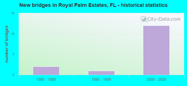
- New bridges - historical statistics
- 21980-1989
- 11990-1999
- 122000-2009


- Bridge Condition - Deck
- 40.0%Very good
- 60.0%Good

- Bridge Condition - Superstructure
- 20.0%Very good
- 80.0%Good

- Bridge Condition - Substructure
- 60.0%Very good
- 40.0%Good

- Bridge Condition - Channel
- 33.3%Very good
- 33.3%Good
- 33.3%Satisfactory
Find on map >> Show street view
Structure Number: 930439, Location: Southern Blvd / E-3 Canal (Lat: 26.678000, Lng: -80.128681), Route carried "on" structure: US 98, Year Built: 1988, Year Reconstructed: 2005, Status: Open, Structure Length: 0.74m (2.43ft), Average Daily Traffic: 37,500 (year 2021), Truck Traffic: 8%, Average Future Daily Traffic: 65,063 (year 2042), Design Load: HS 20, Features Intersected: E-3 CANAL
Minimum Vertical Clearance: 30+ m (98+ ft), Kilometerpoint: 26.269, Lanes on structure: 4, Base Highway Network: Yes, Owner: State Highway Agency, Approaching Roadway Width: 20.3m (66.6ft), Skew: 20 degrees, Material/Design: Concrete, Design/Construction: Culvert, Number Of Spans In Main Unit: 2, Length of Maximum Span: 3.7m (12.1ft), Curb or Sidewalk Widths: Left: 1.9m (6.2ft), Right: 1.9m (6.2ft)
Condition: Channel: Satisfactory, Culverts: Satisfactory, Operating Rating: 47.4 metric tons, Method Used To Determine Operating Rating: Load Factor (LF), Inventory Rating: 29.4 metric tons, Method Used To Determine Inventory Rating: Load Factor (LF), Structural Evaluation: Equal to present minimum criteria, Waterway Adequacy: Superior to present desirable criteria, Approach Roadway Alignment: Equal to present desirable criteria, Designated Inspection Frequency: Every 22 months, Underwater Inspection Frequency: Every 20 months, Inspection Date: May 2021, Underwater Inspection Date: July 2021
Find on map >> Show street view
Structure Number: 930457, Location: 1.5 miles E of Jog Rd (Lat: 26.678306, Lng: -80.120556), Route carried "on" structure: US 98, Year Built: 2005, Status: Open, Structure Length: 13.80m (45.28ft), Average Daily Traffic: 57,500 (year 2020), Truck Traffic: 7%, Average Future Daily Traffic: 99,762 (year 2042), Design Load: HS 20+Mod, Features Intersected: Haverhill Rd. & U Turns, Facility Carried by Structure: SR 80/Southern Bvd
Minimum Vertical Clearance: 30+ m (98+ ft), Kilometerpoint: 26.923, Lanes on structure: 6, Lanes under structure: 8, Base Highway Network: Yes, Owner: State Highway Agency, Approaching Roadway Width: 34.2m (112.2ft), Skew: 20 degrees, Material/Design: Steel continuous, Design/Construction: Stringer/Multi-beam, Number Of Spans In Main Unit: 3, Length of Maximum Span: 58.0m (190.3ft), Curb-To-Curb Width: 34.2m (112.2ft), Out-to-Out Width: 35.2m (115.5ft)
Condition: Deck: Very good, Superstructure: Good, Substructure: Very good, Inventory Rating: 54.6 metric tons, Method Used To Determine Inventory Rating: Load Factor (LF), Structural Evaluation: Better than present minimum criteria, Deck Geometry: Superior to present desirable criteria, Underclear: Superior to present desirable criteria, Approach Roadway Alignment: Equal to present desirable criteria, Designated Inspection Frequency: Every 24 months, Inspection Date: March 2021, Deck Structure Type: Concrete Cast-file-Place
Find on map >> Show street view
Structure Number: 930459, Location: SW quadrant PB Int Airprt (Lat: 26.678056, Lng: -80.111944), Route carried "on" structure: State highway 80, Year Built: 2005, Status: Open, Structure Length: 13.80m (45.28ft), Average Daily Traffic: 60,000 (year 2021), Truck Traffic: 8%, Average Future Daily Traffic: 104,100 (year 2042), Design Load: HS 20+Mod, Features Intersected: SR 809 (Military Trail)
Minimum Vertical Clearance: 30+ m (98+ ft), Kilometerpoint: 27.739, Lanes on structure: 6, Lanes under structure: 10, Base Highway Network: Yes, Owner: State Highway Agency, Approaching Roadway Width: 34.2m (112.2ft), Skew: 20 degrees, Material/Design: Steel continuous, Design/Construction: Stringer/Multi-beam, Number Of Spans In Main Unit: 3, Length of Maximum Span: 58.0m (190.3ft), Curb-To-Curb Width: 34.2m (112.2ft), Out-to-Out Width: 35.2m (115.5ft)
Condition: Deck: Very good, Superstructure: Good, Substructure: Very good, Inventory Rating: 54.6 metric tons, Method Used To Determine Inventory Rating: Load Factor (LF), Structural Evaluation: Better than present minimum criteria, Deck Geometry: Superior to present desirable criteria, Underclear: Better than present minimum criteria, Approach Roadway Alignment: Equal to present desirable criteria, Designated Inspection Frequency: Every 24 months, Inspection Date: August 2021, Deck Structure Type: Concrete Cast-file-Place
Find on map >> Show street view
Structure Number: 930525, Location: East Tpk & West SR 809 (Lat: 26.678833, Lng: -80.145222), Route carried "on" structure: US 98, Year Built: 2004, Status: Open, Structure Length: 12.80m (41.99ft), Average Daily Traffic: 79,000 (year 2020), Truck Traffic: 7%, Average Future Daily Traffic: 137,065 (year 2042), Design Load: HS 20+Mod, Features Intersected: Jog Rd. & Turn Arounds, Facility Carried by Structure: SR 80/Southern Bvd
Minimum Vertical Clearance: 30+ m (98+ ft), Kilometerpoint: 24.451, Lanes on structure: 6, Lanes under structure: 12, Base Highway Network: Yes, Owner: State Highway Agency, Approaching Roadway Width: 33.6m (110.2ft), Skew: 10 degrees, Material/Design: Steel continuous, Design/Construction: Stringer/Multi-beam, Number Of Spans In Main Unit: 3, Length of Maximum Span: 50.0m (164.0ft), Curb-To-Curb Width: 33.6m (110.2ft), Out-to-Out Width: 35.2m (115.5ft)
Condition: Deck: Good, Superstructure: Very good, Substructure: Good, Operating Rating: 64.3 metric tons, Method Used To Determine Operating Rating: Load Factor (LF), Inventory Rating: 38.5 metric tons, Method Used To Determine Inventory Rating: Load Factor (LF), Structural Evaluation: Better than present minimum criteria, Deck Geometry: Superior to present desirable criteria, Underclear: Equal to present minimum criteria, Approach Roadway Alignment: Equal to present desirable criteria, Designated Inspection Frequency: Every 24 months, Inspection Date: October 2020, Deck Structure Type: Concrete Cast-file-Place
Find on map >> Show street view
Structure Number: 934223, Location: 0.5 MI W OF HAVERHILL RD (Lat: 26.681478, Lng: -80.128469), Route carried "on" structure: City street , Year Built: 1984, Status: Open, Structure Length: 2.29m (7.51ft), Average Daily Traffic: 720 (year 2020), Truck Traffic: 2%, Average Future Daily Traffic: 880 (year 2042), Design Load: HS 20, Features Intersected: LWDD E-3 CANAL, Facility Carried by Structure: WALLIS ROAD
Minimum Vertical Clearance: 30+ m (98+ ft), Kilometerpoint: 0.000, Lanes on structure: 2, Owner: County Highway Agency, Approaching Roadway Width: 6.9m (22.6ft), Material/Design: Prestressed concrete, Design/Construction: Slab, Number Of Spans In Main Unit: 3, Length of Maximum Span: 7.7m (25.3ft), Curb or Sidewalk Widths: Left: 1.5m (4.9ft), Right: 1.5m (4.9ft), Curb-To-Curb Width: 8.6m (28.2ft), Out-to-Out Width: 12.5m (41.0ft)
Condition: Deck: Good, Superstructure: Good, Substructure: Good, Channel: Good, Operating Rating: 70.9 metric tons, Method Used To Determine Operating Rating: Allowable Stress (AS), Inventory Rating: 59.9 metric tons, Method Used To Determine Inventory Rating: Allowable Stress (AS), Structural Evaluation: Better than present minimum criteria, Deck Geometry: Somewhat better than minimum adequacy, Waterway Adequacy: Equal to present desirable criteria, Approach Roadway Alignment: Equal to present desirable criteria, Designated Inspection Frequency: Every 24 months, Underwater Inspection Frequency: Every 24 months, Inspection Date: June 2020, Underwater Inspection Date: June 2020, Deck Structure Type: Concrete Precast Panels, Wearing Surface/Protective System: Wearing Surface: Bituminous
Find on map >> Show street view
Structure Number: 934273, Location: AT SOUTHERN BLVD. (Lat: 26.678167, Lng: -80.145197), Route carried "on" structure: County highway , Year Built: 1993, Year Reconstructed: 2014, Status: Open, Structure Length: 5.49m (18.01ft), Average Daily Traffic: 36,794 (year 2020), Truck Traffic: 5%, Average Future Daily Traffic: 62,283 (year 2042), Design Load: HL 93, Features Intersected: SFWMD C-51 CANAL, Facility Carried by Structure: JOG ROAD
Minimum Vertical Clearance: 30+ m (98+ ft), Kilometerpoint: 16.734, Lanes on structure: 9, Base Highway Network: Yes, Owner: County Highway Agency, Approaching Roadway Width: 37.7m (123.7ft), Skew: 20 degrees, Material/Design: Prestressed concrete, Design/Construction: Slab, Number Of Spans In Main Unit: 5, Length of Maximum Span: 12.2m (40.0ft), Curb or Sidewalk Widths: Left: 2.0m (6.6ft), Right: 2.0m (6.6ft), Curb-To-Curb Width: 43.2m (141.7ft), Out-to-Out Width: 46.7m (153.2ft)
Condition: Deck: Good, Superstructure: Good, Substructure: Very good, Channel: Very good, Operating Rating: 61.7 metric tons, Method Used To Determine Operating Rating: Load and Resistance Factor (LRFR), Inventory Rating: 51.9 metric tons, Method Used To Determine Inventory Rating: Load and Resistance Factor (LRFR), Structural Evaluation: Better than present minimum criteria, Deck Geometry: Superior to present desirable criteria, Waterway Adequacy: Equal to present desirable criteria, Approach Roadway Alignment: Equal to present desirable criteria, Designated Inspection Frequency: Every 24 months, Underwater Inspection Frequency: Every 24 months, Inspection Date: September 2020, Underwater Inspection Date: September 2020, Deck Structure Type: Concrete Precast Panels, Wearing Surface/Protective System: Wearing Surface: Bituminous
Find on map >> Show street view
Structure Number: 930457, Location: 1.5 miles E of Jog Rd (Lat: 26.678306, Lng: -80.120556), Route carried "under" structure: County highway , Year Built: 2005, Structure Length: 0. m, Average Daily Traffic: 18,000 (year 2004), Truck Traffic: 5%, Features Intersected: Haverhill Rd. & U Turns, Facility Carried by Structure: SR 80/Southern Bvd
Minimum Vertical Clearance: 5.43m (17.81ft), Kilometerpoint: 0.000, Lanes on structure: 6, Lanes under structure: 6, Material/Design: Steel continuous, Design/Construction: Stringer/Multi-beam, Length of Maximum Span: 58.0m (190.3ft)
Find on map >> Show street view
Structure Number: 930457, Location: 1.5 miles E of Jog Rd (Lat: 26.678306, Lng: -80.120556), Route carried "under" structure: Ramp US 98, Year Built: 2005, Structure Length: 0. m, Average Daily Traffic: 200 (year 2006), Truck Traffic: 1%, Features Intersected: Haverhill Rd. & U Turns, Facility Carried by Structure: SR 80/Southern Bvd
Minimum Vertical Clearance: 5.89m (19.32ft), Kilometerpoint: 0.000, Lanes on structure: 6, Lanes under structure: 1, Material/Design: Steel continuous, Design/Construction: Stringer/Multi-beam, Length of Maximum Span: 58.0m (190.3ft)
Find on map >> Show street view
Structure Number: 930457, Location: 1.5 miles E of Jog Rd (Lat: 26.678306, Lng: -80.120556), Route carried "under" structure: Ramp US 98, Year Built: 2005, Structure Length: 0. m, Average Daily Traffic: 200 (year 2006), Truck Traffic: 1%, Features Intersected: Haverhill Rd. & U Turns, Facility Carried by Structure: SR 80/Southern Bvd
Minimum Vertical Clearance: 5.80m (19.03ft), Kilometerpoint: 0.000, Lanes on structure: 6, Lanes under structure: 1, Material/Design: Steel continuous, Design/Construction: Stringer/Multi-beam, Length of Maximum Span: 58.0m (190.3ft)
Find on map >> Show street view
Structure Number: 930459, Location: SW quadrant PB Int Airprt (Lat: 26.678056, Lng: -80.111944), Route carried "under" structure: Ramp US 98, Year Built: 2005, Structure Length: 0. m, Average Daily Traffic: 7,800 (year 2021), Truck Traffic: 1%, Features Intersected: SR 809 (Military Trail), Facility Carried by Structure: SR 80-Southern Bvd
Minimum Vertical Clearance: 5.79m (19.00ft), Kilometerpoint: 0.000, Lanes on structure: 6, Lanes under structure: 1, Material/Design: Steel continuous, Design/Construction: Stringer/Multi-beam, Length of Maximum Span: 58.0m (190.3ft)
Find on map >> Show street view
Structure Number: 930459, Location: SW quadrant PB Int Airprt (Lat: 26.678056, Lng: -80.111944), Route carried "under" structure: Ramp US 98, Year Built: 2005, Structure Length: 0. m, Average Daily Traffic: 7,400 (year 2021), Truck Traffic: 4%, Features Intersected: SR 809 (Military Trail), Facility Carried by Structure: SR 80-Southern Bvd
Minimum Vertical Clearance: 5.68m (18.64ft), Kilometerpoint: 0.026, Lanes on structure: 6, Lanes under structure: 1, Material/Design: Steel continuous, Design/Construction: Stringer/Multi-beam, Length of Maximum Span: 58.0m (190.3ft)
Find on map >> Show street view
Structure Number: 930459, Location: SW quadrant PB Int Airprt (Lat: 26.678056, Lng: -80.111944), Route carried "under" structure: State highway 809, Year Built: 2005, Structure Length: 0. m, Average Daily Traffic: 40,000 (year 2021), Truck Traffic: 4%, Features Intersected: SR 809 (Military Trail), Facility Carried by Structure: SR 80-Southern Bvd
Minimum Vertical Clearance: 5.64m (18.50ft), Kilometerpoint: 0.026, Lanes on structure: 6, Lanes under structure: 8, Material/Design: Steel continuous, Design/Construction: Stringer/Multi-beam, Length of Maximum Span: 58.0m (190.3ft)
Find on map >> Show street view
Structure Number: 930525, Location: East Tpk & West SR 809 (Lat: 26.678833, Lng: -80.145222), Route carried "under" structure: County highway , Year Built: 2004, Structure Length: 0. m, Average Daily Traffic: 9,500 (year 2020), Truck Traffic: 5%, Features Intersected: Jog Rd. & Turn Arounds, Facility Carried by Structure: SR 80/Southern Bvd
Minimum Vertical Clearance: 5.27m (17.29ft), Kilometerpoint: 0.000, Lanes on structure: 6, Lanes under structure: 10, Material/Design: Steel continuous, Design/Construction: Stringer/Multi-beam, Length of Maximum Span: 50.0m (164.0ft)
Find on map >> Show street view
Structure Number: 930525, Location: East Tpk & West SR 809 (Lat: 26.678833, Lng: -80.145222), Route carried "under" structure: Ramp US 98, Year Built: 2004, Structure Length: 0. m, Average Daily Traffic: 79,000 (year 2020), Truck Traffic: 7%, Features Intersected: Jog Rd. & Turn Arounds, Facility Carried by Structure: SR 80/Southern Bvd
Minimum Vertical Clearance: 5.21m (17.09ft), Kilometerpoint: 24.584, Lanes on structure: 6, Lanes under structure: 1, Material/Design: Steel continuous, Design/Construction: Stringer/Multi-beam, Length of Maximum Span: 50.0m (164.0ft)
Find on map >> Show street view
Structure Number: 930525, Location: East Tpk & West SR 809 (Lat: 26.678833, Lng: -80.145222), Route carried "under" structure: Ramp US 98, Year Built: 2004, Structure Length: 0. m, Average Daily Traffic: 79,000 (year 2020), Truck Traffic: 7%, Features Intersected: Jog Rd. & Turn Arounds, Facility Carried by Structure: SR 80/Southern Bvd
Minimum Vertical Clearance: 5.21m (17.09ft), Kilometerpoint: 24.462, Lanes on structure: 6, Lanes under structure: 1, Material/Design: Steel continuous, Design/Construction: Stringer/Multi-beam, Length of Maximum Span: 50.0m (164.0ft)