Bridge Statistics for Roxana, Illinois (IL)
Condition, Traffic, Stress, Structural Evaluation, Project Costs
- National Bridge Inventory (NBI) Statistics
- 28Number of bridges
- 325ft / 98.8mTotal length
- $1,368,000Total costs
- 381,550Total average daily traffic
- 43,756Total average daily truck traffic
- National Bridge Inventory (NBI) Registered Bridges for Roxana
- No street view available for this location
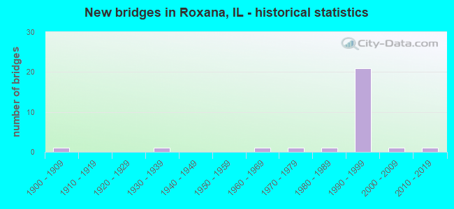
- New bridges - historical statistics
- 11900-1909
- 11930-1939
- 11960-1969
- 11970-1979
- 11980-1989
- 211990-1999
- 12000-2009
- 12010-2019


- Bridge Condition - Deck
- 26.7%Very good
- 60.0%Good
- 13.3%Fair

- Bridge Condition - Superstructure
- 60.0%Very good
- 26.7%Good
- 13.3%Fair

- Bridge Condition - Substructure
- 60.0%Very good
- 26.7%Good
- 6.7%Satisfactory
- 6.7%Poor

- Bridge Condition - Channel
- 14.3%Excellent
- 28.6%Very good
- 14.3%Good
- 14.3%Satisfactory
- 28.6%Fair

- Bridge Condition - Culverts
- 33.3%Very good
- 66.7%Good
Find on map >> Show street view
Structure Number: 600261, Location: BETWEEN EDWVLL-ROXAN (Lat: 38.832383, Lng: -90.031869), Route carried "on" structure: County highway , Year Built: 1990, Status: Open, Structure Length: 5.55m (18.21ft), Average Daily Traffic: 1,400 (year 2021), Truck Traffic: 17%, Average Future Daily Traffic: 1,855 (year 2032), Design Load: HS 20, Features Intersected: INDIAN CREEK, Facility Carried by Structure: OLD ALTON-EDW RD C
Minimum Vertical Clearance: 30+ m (98+ ft), Kilometerpoint: 0.756, Lanes on structure: 2, Owner: State Highway Agency, Approaching Roadway Width: 6.7m (22.0ft), Material/Design: Prestressed concrete, Design/Construction: Box Beam or Girders - Multiple, Number Of Spans In Main Unit: 4, Length of Maximum Span: 13.7m (44.9ft), Curb-To-Curb Width: 8.5m (27.9ft), Out-to-Out Width: 8.5m (27.9ft)
Condition: Deck: Good, Superstructure: Good, Substructure: Good, Channel: Satisfactory, Operating Rating: 57.0 metric tons, Method Used To Determine Operating Rating: Load Factor (LF) rating reported by rating factor (RF) method using MS18 loading, Inventory Rating: 34.0 metric tons, Method Used To Determine Inventory Rating: Load Factor (LF) rating reported by rating factor (RF) method using MS18 loading, Structural Evaluation: Better than present minimum criteria, Deck Geometry: Somewhat better than minimum adequacy, Waterway Adequacy: Equal to present minimum criteria, Approach Roadway Alignment: Equal to present desirable criteria, Length Of Structure Improvement: 5.55m (18.21ft), Designated Inspection Frequency: Every 48 months, Other Special Inspection Frequency: Every 24 months, Inspection Date: August 2020, Other Special Inspection Date: August 2020, Bridge Improvement Cost: $367,000, Roadway Improvement Cost: $37,000, Total Project Cost: $551,000, Deck Structure Type: Concrete Precast Panels, Wearing Surface/Protective System: Wearing Surface: Bituminous, Membrane: Built-up
Find on map >> Show street view
Structure Number: 60028, Location: 4 MI N OF I-270 (Lat: 38.817628, Lng: -90.041883), Route carried "on" structure: State highway 255, Year Built: 1995, Status: Open, Structure Length: 10.15m (33.30ft), Average Daily Traffic: 27,900 (year 2021), Truck Traffic: 13%, Average Future Daily Traffic: 13,091 (year 2032), Design Load: HS 20, Features Intersected: UNION PACIFIC RR
Minimum Vertical Clearance: 30+ m (98+ ft), Kilometerpoint: 6.598, Lanes on structure: 2, Base Highway Network: Yes, Owner: State Highway Agency, Approaching Roadway Width: 12.8m (42.0ft), Skew: 2 degrees, Material/Design: Steel continuous, Design/Construction: Stringer/Multi-beam, Number Of Spans In Main Unit: 3, Length of Maximum Span: 38.4m (126.0ft), Curb-To-Curb Width: 12.6m (41.3ft), Out-to-Out Width: 13.5m (44.3ft)
Condition: Deck: Good, Superstructure: Very good, Substructure: Very good, Operating Rating: 67.4 metric tons, Method Used To Determine Operating Rating: Load Factor (LF) rating reported by rating factor (RF) method using MS18 loading, Inventory Rating: 40.2 metric tons, Method Used To Determine Inventory Rating: Load Factor (LF) rating reported by rating factor (RF) method using MS18 loading, Structural Evaluation: Equal to present desirable criteria, Deck Geometry: Better than present minimum criteria, Underclear: Superior to present desirable criteria, Approach Roadway Alignment: Equal to present desirable criteria, Designated Inspection Frequency: Every 24 months, Inspection Date: November 2020, Deck Structure Type: Concrete Cast-file-Place, Wearing Surface/Protective System: Deck Protection: Epoxy Coated Reinforcing
Find on map >> Show street view
Structure Number: 600281, Location: 4 MI N OF I-270 (Lat: 38.817472, Lng: -90.041867), Route carried "on" structure: State highway 255, Year Built: 1995, Status: Open, Structure Length: 10.15m (33.30ft), Average Daily Traffic: 27,900 (year 2021), Truck Traffic: 13%, Average Future Daily Traffic: 13,091 (year 2032), Design Load: HS 20, Features Intersected: UNION PACIFIC RR
Minimum Vertical Clearance: 30+ m (98+ ft), Kilometerpoint: 6.582, Lanes on structure: 2, Base Highway Network: Yes, Owner: State Highway Agency, Approaching Roadway Width: 12.8m (42.0ft), Skew: 2 degrees, Material/Design: Steel continuous, Design/Construction: Stringer/Multi-beam, Number Of Spans In Main Unit: 3, Length of Maximum Span: 38.4m (126.0ft), Curb-To-Curb Width: 12.6m (41.3ft), Out-to-Out Width: 13.5m (44.3ft)
Condition: Deck: Very good, Superstructure: Very good, Substructure: Very good, Operating Rating: 68.0 metric tons, Method Used To Determine Operating Rating: Load Factor (LF) rating reported by rating factor (RF) method using MS18 loading, Inventory Rating: 40.8 metric tons, Method Used To Determine Inventory Rating: Load Factor (LF) rating reported by rating factor (RF) method using MS18 loading, Structural Evaluation: Equal to present desirable criteria, Deck Geometry: Better than present minimum criteria, Underclear: Superior to present desirable criteria, Approach Roadway Alignment: Equal to present desirable criteria, Designated Inspection Frequency: Every 24 months, Inspection Date: November 2020, Deck Structure Type: Concrete Cast-file-Place, Wearing Surface/Protective System: Deck Protection: Epoxy Coated Reinforcing
Find on map >> Show street view
Structure Number: 600282, Location: .03 W. OF OLD WANDA (Lat: 38.811767, Lng: -90.041983), Route carried "on" structure: State highway 255, Year Built: 1995, Status: Open, Structure Length: 3.61m (11.84ft), Average Daily Traffic: 27,900 (year 2021), Truck Traffic: 13%, Average Future Daily Traffic: 13,091 (year 2032), Design Load: HS 20, Features Intersected: WAGON WHEEL ROXANA
Minimum Vertical Clearance: 30+ m (98+ ft), Kilometerpoint: 5.987, Lanes on structure: 2, Lanes under structure: 2, Base Highway Network: Yes, Owner: State Highway Agency, Approaching Roadway Width: 12.8m (42.0ft), Material/Design: Prestressed concrete, Design/Construction: Stringer/Multi-beam, Number Of Spans In Main Unit: 1, Number Of Approach Spans: 2, Length of Maximum Span: 21.2m (69.6ft), Curb-To-Curb Width: 12.3m (40.4ft), Out-to-Out Width: 13.2m (43.3ft)
Condition: Deck: Good, Superstructure: Very good, Substructure: Very good, Operating Rating: 63.5 metric tons, Method Used To Determine Operating Rating: Load Factor (LF) rating reported by rating factor (RF) method using MS18 loading, Inventory Rating: 37.9 metric tons, Method Used To Determine Inventory Rating: Load Factor (LF) rating reported by rating factor (RF) method using MS18 loading, Structural Evaluation: Equal to present desirable criteria, Deck Geometry: Better than present minimum criteria, Underclear: Better than present minimum criteria, Approach Roadway Alignment: Equal to present desirable criteria, Designated Inspection Frequency: Every 48 months, Inspection Date: November 2020, Deck Structure Type: Concrete Cast-file-Place, Wearing Surface/Protective System: Deck Protection: Epoxy Coated Reinforcing
Find on map >> Show street view
Structure Number: 600283, Location: .04 W. OF OLD WANDA (Lat: 38.811614, Lng: -90.042003), Route carried "on" structure: State highway 255, Year Built: 1995, Status: Open, Structure Length: 3.61m (11.84ft), Average Daily Traffic: 27,900 (year 2021), Truck Traffic: 13%, Average Future Daily Traffic: 13,091 (year 2032), Design Load: HS 20, Features Intersected: WAGON WHEEL ROXANA
Minimum Vertical Clearance: 30+ m (98+ ft), Kilometerpoint: 5.971, Lanes on structure: 2, Lanes under structure: 2, Base Highway Network: Yes, Owner: State Highway Agency, Approaching Roadway Width: 12.8m (42.0ft), Material/Design: Prestressed concrete, Design/Construction: Stringer/Multi-beam, Number Of Spans In Main Unit: 1, Number Of Approach Spans: 2, Length of Maximum Span: 21.2m (69.6ft), Curb-To-Curb Width: 12.3m (40.4ft), Out-to-Out Width: 13.2m (43.3ft)
Condition: Deck: Good, Superstructure: Very good, Substructure: Very good, Operating Rating: 63.5 metric tons, Method Used To Determine Operating Rating: Load Factor (LF) rating reported by rating factor (RF) method using MS18 loading, Inventory Rating: 37.9 metric tons, Method Used To Determine Inventory Rating: Load Factor (LF) rating reported by rating factor (RF) method using MS18 loading, Structural Evaluation: Equal to present desirable criteria, Deck Geometry: Better than present minimum criteria, Underclear: Better than present minimum criteria, Approach Roadway Alignment: Equal to present desirable criteria, Designated Inspection Frequency: Every 48 months, Inspection Date: November 2020, Deck Structure Type: Concrete Cast-file-Place, Wearing Surface/Protective System: Deck Protection: Epoxy Coated Reinforcing
Find on map >> Show street view
Structure Number: 600284, Location: 1/4 M W OF S.ROXANA (Lat: 38.832639, Lng: -90.043481), Route carried "on" structure: State highway 255, Year Built: 1995, Status: Open, Structure Length: 5.39m (17.68ft), Average Daily Traffic: 27,900 (year 2021), Truck Traffic: 13%, Average Future Daily Traffic: 12,349 (year 2032), Design Load: HS 20, Features Intersected: MADISON AVE/FAU 8975
Minimum Vertical Clearance: 30+ m (98+ ft), Kilometerpoint: 8.417, Lanes on structure: 2, Lanes under structure: 2, Base Highway Network: Yes, Owner: State Highway Agency, Approaching Roadway Width: 15.7m (51.5ft), Material/Design: Prestressed concrete, Design/Construction: Stringer/Multi-beam, Number Of Spans In Main Unit: 2, Number Of Approach Spans: 1, Length of Maximum Span: 33.5m (109.9ft), Curb-To-Curb Width: 15.7m (51.5ft), Out-to-Out Width: 16.7m (54.8ft)
Condition: Deck: Good, Superstructure: Good, Substructure: Good, Operating Rating: 86.5 metric tons, Method Used To Determine Operating Rating: Load Factor (LF) rating reported by rating factor (RF) method using MS18 loading, Inventory Rating: 47.0 metric tons, Method Used To Determine Inventory Rating: Load Factor (LF) rating reported by rating factor (RF) method using MS18 loading, Structural Evaluation: Better than present minimum criteria, Deck Geometry: Superior to present desirable criteria, Underclear: Equal to present minimum criteria, Approach Roadway Alignment: Equal to present desirable criteria, Designated Inspection Frequency: Every 24 months, Inspection Date: November 2020, Deck Structure Type: Concrete Cast-file-Place, Wearing Surface/Protective System: Deck Protection: Epoxy Coated Reinforcing
Find on map >> Show street view
Structure Number: 600285, Location: 1/4 MI W S. ROXANA (Lat: 38.832919, Lng: -90.043481), Route carried "on" structure: State highway 255, Year Built: 1995, Status: Open, Structure Length: 5.39m (17.68ft), Average Daily Traffic: 27,900 (year 2021), Truck Traffic: 13%, Average Future Daily Traffic: 12,349 (year 2032), Design Load: HS 20, Features Intersected: MADISON AVE/FAU8975
Minimum Vertical Clearance: 30+ m (98+ ft), Kilometerpoint: 8.433, Lanes on structure: 2, Lanes under structure: 2, Base Highway Network: Yes, Owner: State Highway Agency, Approaching Roadway Width: 12.4m (40.7ft), Material/Design: Prestressed concrete, Design/Construction: Stringer/Multi-beam, Number Of Spans In Main Unit: 2, Number Of Approach Spans: 1, Length of Maximum Span: 33.5m (109.9ft), Curb-To-Curb Width: 12.4m (40.7ft), Out-to-Out Width: 13.4m (44.0ft)
Condition: Deck: Good, Superstructure: Good, Substructure: Good, Operating Rating: 83.3 metric tons, Method Used To Determine Operating Rating: Load Factor (LF) rating reported by rating factor (RF) method using MS18 loading, Inventory Rating: 40.8 metric tons, Method Used To Determine Inventory Rating: Load Factor (LF) rating reported by rating factor (RF) method using MS18 loading, Structural Evaluation: Better than present minimum criteria, Deck Geometry: Better than present minimum criteria, Underclear: Equal to present minimum criteria, Approach Roadway Alignment: Equal to present desirable criteria, Designated Inspection Frequency: Every 24 months, Inspection Date: November 2020, Deck Structure Type: Concrete Cast-file-Place, Wearing Surface/Protective System: Deck Protection: Epoxy Coated Reinforcing
Find on map >> Show street view
Structure Number: 600286, Location: IN ROXANNA (Lat: 38.851433, Lng: -90.051969), Route carried "on" structure: State highway 255, Year Built: 1995, Status: Open, Structure Length: 7.77m (25.49ft), Average Daily Traffic: 23,000 (year 2021), Truck Traffic: 11%, Average Future Daily Traffic: 10,335 (year 2032), Design Load: HS 20, Features Intersected: FAP 789 IL 143
Minimum Vertical Clearance: 30+ m (98+ ft), Kilometerpoint: 10.621, Lanes on structure: 2, Lanes under structure: 4, Base Highway Network: Yes, Owner: State Highway Agency, Approaching Roadway Width: 12.8m (42.0ft), Skew: 4 degrees, Material/Design: Steel continuous, Design/Construction: Stringer/Multi-beam, Number Of Spans In Main Unit: 2, Length of Maximum Span: 39.4m (129.3ft), Curb-To-Curb Width: 12.2m (40.0ft), Out-to-Out Width: 13.2m (43.3ft)
Condition: Deck: Good, Superstructure: Very good, Substructure: Very good, Operating Rating: 76.8 metric tons, Method Used To Determine Operating Rating: Load Factor (LF) rating reported by rating factor (RF) method using MS18 loading, Inventory Rating: 46.0 metric tons, Method Used To Determine Inventory Rating: Load Factor (LF) rating reported by rating factor (RF) method using MS18 loading, Structural Evaluation: Equal to present desirable criteria, Deck Geometry: Better than present minimum criteria, Underclear: Equal to present minimum criteria, Approach Roadway Alignment: Equal to present desirable criteria, Designated Inspection Frequency: Every 24 months, Inspection Date: November 2020, Deck Structure Type: Concrete Cast-file-Place, Wearing Surface/Protective System: Deck Protection: Epoxy Coated Reinforcing
Find on map >> Show street view
Structure Number: 600287, Location: IN ROXANNA (Lat: 38.851314, Lng: -90.051933), Route carried "on" structure: State highway 255, Year Built: 1995, Status: Open, Structure Length: 7.17m (23.52ft), Average Daily Traffic: 23,000 (year 2021), Truck Traffic: 11%, Average Future Daily Traffic: 10,335 (year 2032), Design Load: HS 20, Features Intersected: FAP 789 IL 143
Minimum Vertical Clearance: 30+ m (98+ ft), Kilometerpoint: 10.605, Lanes on structure: 2, Lanes under structure: 4, Base Highway Network: Yes, Owner: State Highway Agency, Approaching Roadway Width: 12.8m (42.0ft), Skew: 4 degrees, Material/Design: Steel continuous, Design/Construction: Stringer/Multi-beam, Number Of Spans In Main Unit: 2, Length of Maximum Span: 35.1m (115.2ft), Curb-To-Curb Width: 12.2m (40.0ft), Out-to-Out Width: 13.2m (43.3ft)
Condition: Deck: Good, Superstructure: Very good, Substructure: Very good, Operating Rating: 81.3 metric tons, Method Used To Determine Operating Rating: Load Factor (LF) rating reported by rating factor (RF) method using MS18 loading, Inventory Rating: 48.6 metric tons, Method Used To Determine Inventory Rating: Load Factor (LF) rating reported by rating factor (RF) method using MS18 loading, Structural Evaluation: Equal to present desirable criteria, Deck Geometry: Better than present minimum criteria, Underclear: Equal to present minimum criteria, Approach Roadway Alignment: Equal to present desirable criteria, Designated Inspection Frequency: Every 24 months, Inspection Date: November 2020, Deck Structure Type: Concrete Cast-file-Place, Wearing Surface/Protective System: Deck Protection: Epoxy Coated Reinforcing
Find on map >> Show street view
Structure Number: 600313, Location: 2 MI. SO. OF IL 143 (Lat: 38.821453, Lng: -90.042539), Route carried "on" structure: State highway 255, Year Built: 1995, Status: Open, Structure Length: 2.68m (8.79ft), Average Daily Traffic: 27,900 (year 2021), Truck Traffic: 13%, Average Future Daily Traffic: 13,091 (year 2032), Design Load: HS 20, Features Intersected: FARMERS ACCESS RD
Minimum Vertical Clearance: 30+ m (98+ ft), Kilometerpoint: 7.000, Lanes on structure: 2, Base Highway Network: Yes, Owner: State Highway Agency, Approaching Roadway Width: 12.2m (40.0ft), Material/Design: Prestressed concrete, Design/Construction: Stringer/Multi-beam, Number Of Spans In Main Unit: 1, Length of Maximum Span: 26.1m (85.6ft), Curb-To-Curb Width: 12.2m (40.0ft), Out-to-Out Width: 13.2m (43.3ft)
Condition: Deck: Very good, Superstructure: Very good, Substructure: Very good, Operating Rating: 75.5 metric tons, Method Used To Determine Operating Rating: Load Factor (LF) rating reported by rating factor (RF) method using MS18 loading, Inventory Rating: 39.2 metric tons, Method Used To Determine Inventory Rating: Load Factor (LF) rating reported by rating factor (RF) method using MS18 loading, Structural Evaluation: Equal to present desirable criteria, Deck Geometry: Better than present minimum criteria, Approach Roadway Alignment: Equal to present desirable criteria, Designated Inspection Frequency: Every 48 months, Inspection Date: November 2020, Deck Structure Type: Concrete Cast-file-Place, Wearing Surface/Protective System: Deck Protection: Epoxy Coated Reinforcing
Find on map >> Show street view
Structure Number: 600314, Location: 2 MI. SO. OF IL 143 (Lat: 38.821300, Lng: -90.042506), Route carried "on" structure: State highway 255, Year Built: 1995, Status: Open, Structure Length: 2.68m (8.79ft), Average Daily Traffic: 27,900 (year 2021), Truck Traffic: 13%, Average Future Daily Traffic: 13,091 (year 2032), Design Load: HS 20, Features Intersected: FARMERS ACCESS RD
Minimum Vertical Clearance: 30+ m (98+ ft), Kilometerpoint: 6.984, Lanes on structure: 2, Base Highway Network: Yes, Owner: State Highway Agency, Approaching Roadway Width: 12.2m (40.0ft), Material/Design: Prestressed concrete, Design/Construction: Stringer/Multi-beam, Number Of Spans In Main Unit: 1, Length of Maximum Span: 26.1m (85.6ft), Curb-To-Curb Width: 12.2m (40.0ft), Out-to-Out Width: 13.2m (43.3ft)
Condition: Deck: Very good, Superstructure: Very good, Substructure: Very good, Operating Rating: 75.5 metric tons, Method Used To Determine Operating Rating: Load Factor (LF) rating reported by rating factor (RF) method using MS18 loading, Inventory Rating: 39.2 metric tons, Method Used To Determine Inventory Rating: Load Factor (LF) rating reported by rating factor (RF) method using MS18 loading, Structural Evaluation: Equal to present desirable criteria, Deck Geometry: Better than present minimum criteria, Approach Roadway Alignment: Equal to present desirable criteria, Designated Inspection Frequency: Every 48 months, Inspection Date: November 2020, Deck Structure Type: Concrete Cast-file-Place, Wearing Surface/Protective System: Deck Protection: Epoxy Coated Reinforcing
Find on map >> Show street view
Structure Number: 600349, Location: 3.5 M NW Edwardsvill (Lat: 38.841203, Lng: -90.032444), Route carried "on" structure: State highway 143, Year Built: 2018, Status: Open, Structure Length: 7.62m (25.00ft), Average Daily Traffic: 10,300 (year 2021), Truck Traffic: 7%, Average Future Daily Traffic: 11,978 (year 2032), Design Load: HS 25 or greater, Features Intersected: Indian Creek
Minimum Vertical Clearance: 30+ m (98+ ft), Kilometerpoint: 14.114, Lanes on structure: 2, Base Highway Network: Yes, Owner: State Highway Agency, Approaching Roadway Width: 12.2m (40.0ft), Material/Design: Steel continuous, Design/Construction: Stringer/Multi-beam, Number Of Spans In Main Unit: 3, Length of Maximum Span: 29.3m (96.1ft), Curb-To-Curb Width: 12.2m (40.0ft), Out-to-Out Width: 13.2m (43.3ft)
Condition: Deck: Very good, Superstructure: Very good, Substructure: Very good, Channel: Excellent, Operating Rating: 55.4 metric tons, Method Used To Determine Operating Rating: Load and Resistance Factor Rating (LRFR) rating reported by rating factor(RF) method using HL-93 loadings, Inventory Rating: 42.8 metric tons, Method Used To Determine Inventory Rating: Load and Resistance Factor Rating (LRFR) rating reported by rating factor(RF) method using HL-93 loadings, Structural Evaluation: Equal to present desirable criteria, Deck Geometry: Somewhat better than minimum adequacy, Waterway Adequacy: Superior to present desirable criteria, Approach Roadway Alignment: Equal to present desirable criteria, Designated Inspection Frequency: Every 48 months, Inspection Date: May 2020, Deck Structure Type: Concrete Cast-file-Place, Wearing Surface/Protective System: Deck Protection: Epoxy Coated Reinforcing
Find on map >> Show street view
Structure Number: 602032, Location: 0.17MI N MADISON AVE (Lat: 38.835822, Lng: -90.043467), Route carried "on" structure: State highway 255, Year Built: 1998, Status: Open, Structure Length: 0.81m (2.66ft), Average Daily Traffic: 25,200 (year 2021), Truck Traffic: 12%, Average Future Daily Traffic: 24,698 (year 2032), Design Load: HS 20, Features Intersected: STREAM
Minimum Vertical Clearance: 30+ m (98+ ft), Kilometerpoint: 8.722, Lanes on structure: 4, Base Highway Network: Yes, Owner: State Highway Agency, Approaching Roadway Width: 25.6m (84.0ft), Material/Design: Concrete continuous, Design/Construction: Culvert, Number Of Spans In Main Unit: 3, Length of Maximum Span: 2.7m (8.9ft)
Condition: Channel: Good, Culverts: Good, Operating Rating: 44.1 metric tons, Method Used To Determine Operating Rating: Load Factor (LF) rating reported by rating factor (RF) method using MS18 loading, Inventory Rating: 32.4 metric tons, Method Used To Determine Inventory Rating: Load Factor (LF) rating reported by rating factor (RF) method using MS18 loading, Structural Evaluation: Better than present minimum criteria, Waterway Adequacy: Equal to present desirable criteria, Approach Roadway Alignment: Equal to present desirable criteria, Designated Inspection Frequency: Every 48 months, Inspection Date: November 2020
Find on map >> Show street view
Structure Number: 602033, Location: .5 MI E IL 111 W 310 (Lat: 38.853789, Lng: -90.058678), Route carried "on" structure: State highway 143, Year Built: 1995, Status: Open, Structure Length: 0.70m (2.30ft), Average Daily Traffic: 12,200 (year 2021), Truck Traffic: 5%, Average Future Daily Traffic: 14,946 (year 2032), Design Load: HS 20, Features Intersected: STREAM
Minimum Vertical Clearance: 30+ m (98+ ft), Kilometerpoint: 11.410, Lanes on structure: 4, Base Highway Network: Yes, Owner: State Highway Agency, Approaching Roadway Width: 25.0m (82.0ft), Material/Design: Concrete continuous, Design/Construction: Culvert, Number Of Spans In Main Unit: 3, Length of Maximum Span: 2.4m (7.9ft), Curb-To-Curb Width: 25.0m (82.0ft), Out-to-Out Width: 26.2m (86.0ft)
Condition: Channel: Very good, Culverts: Very good, Operating Rating: 60.9 metric tons, Method Used To Determine Operating Rating: Load Factor (LF) rating reported by rating factor (RF) method using MS18 loading, Inventory Rating: 36.6 metric tons, Method Used To Determine Inventory Rating: Load Factor (LF) rating reported by rating factor (RF) method using MS18 loading, Structural Evaluation: Equal to present desirable criteria, Deck Geometry: Superior to present desirable criteria, Waterway Adequacy: Equal to present minimum criteria, Approach Roadway Alignment: Equal to present desirable criteria, Designated Inspection Frequency: Every 48 months, Inspection Date: May 2020, Deck Structure Type: Concrete Cast-file-Place
Find on map >> Show street view
Structure Number: 603223, Location: 1.8 MI E ILL 111 (Lat: 38.799836, Lng: -90.034464), Route carried "on" structure: Other road , Year Built: 1977, Status: Open, Structure Length: 6.71m (22.01ft), Average Daily Traffic: 7,400 (year 2021), Truck Traffic: 4%, Average Future Daily Traffic: 8,162 (year 2032), Design Load: HS 20, Features Intersected: NORFORK & WESTERN RR, Facility Carried by Structure: FAU 8877
Minimum Vertical Clearance: 30+ m (98+ ft), Kilometerpoint: 5.906, Lanes on structure: 2, Base Highway Network: Yes, Owner: County Highway Agency, Approaching Roadway Width: 12.2m (40.0ft), Skew: 4 degrees, Material/Design: Steel continuous, Design/Construction: Stringer/Multi-beam, Number Of Spans In Main Unit: 3, Length of Maximum Span: 25.3m (83.0ft), Curb-To-Curb Width: 8.7m (28.5ft), Out-to-Out Width: 9.8m (32.2ft)
Condition: Deck: Good, Superstructure: Fair, Substructure: Satisfactory, Operating Rating: 89.4 metric tons, Method Used To Determine Operating Rating: Load Factor (LF) rating reported by rating factor (RF) method using MS18 loading, Inventory Rating: 51.5 metric tons, Method Used To Determine Inventory Rating: Load Factor (LF) rating reported by rating factor (RF) method using MS18 loading, Structural Evaluation: Somewhat better than minimum adequacy, Deck Geometry: Meets minimum limits, Underclear: Superior to present desirable criteria, Approach Roadway Alignment: Equal to present desirable criteria, Length Of Structure Improvement: 6.71m (22.01ft), Designated Inspection Frequency: Every 24 months, Inspection Date: Febuary 2020, Bridge Improvement Cost: $743,000, Roadway Improvement Cost: $74,000, Total Project Cost: $817,000, Deck Structure Type: Concrete Cast-file-Place, Wearing Surface/Protective System: Wearing Surface: Bituminous
Find on map >> Show street view
Structure Number: 603265, Location: 1.0 MI NORTH OF POAG (Lat: 38.804842, Lng: -90.038764), Route carried "on" structure: Other road , Year Built: 1986, Status: Open, Structure Length: 8.75m (28.71ft), Average Daily Traffic: 1,800 (year 2021), Truck Traffic: 12%, Average Future Daily Traffic: 2,597 (year 2032), Design Load: HS 20, Features Intersected: CAHOKIA DIV CANAL, Facility Carried by Structure: FAU 9018/ WANDA RD
Minimum Vertical Clearance: 30+ m (98+ ft), Kilometerpoint: 3.122, Lanes on structure: 2, Owner: County Highway Agency, Approaching Roadway Width: 11.3m (37.1ft), Skew: 1 degrees, Material/Design: Steel continuous, Design/Construction: Stringer/Multi-beam, Number Of Spans In Main Unit: 3, Length of Maximum Span: 35.4m (116.1ft), Curb-To-Curb Width: 9.1m (29.9ft), Out-to-Out Width: 10.1m (33.1ft)
Condition: Deck: Fair, Superstructure: Good, Substructure: Good, Channel: Very good, Operating Rating: 44.4 metric tons, Method Used To Determine Operating Rating: Assigned rating based on Load Factor Design (LFD) reported by rating factor (RF) using MS18 loading, Inventory Rating: 32.4 metric tons, Method Used To Determine Inventory Rating: Assigned rating based on Load Factor Design (LFD) reported by rating factor (RF) using MS18 loading, Structural Evaluation: Better than present minimum criteria, Deck Geometry: Somewhat better than minimum adequacy, Waterway Adequacy: Equal to present desirable criteria, Approach Roadway Alignment: Equal to present desirable criteria, Designated Inspection Frequency: Every 24 months, Inspection Date: Febuary 2020, Deck Structure Type: Concrete Cast-file-Place, Wearing Surface/Protective System: Deck Protection: Epoxy Coated Reinforcing
Find on map >> Show street view
Structure Number: 603278, Location: 3MI NW EDWARDSVILLE (Lat: 38.850422, Lng: -89.999911), Route carried "on" structure: County highway , Year Built: 1997, Status: Open, Structure Length: 9.19m (30.15ft), Average Daily Traffic: 100 (year 2021), Truck Traffic: 19%, Average Future Daily Traffic: 186 (year 2032), Design Load: HS 20, Features Intersected: INDIAN CREEK, Facility Carried by Structure: TR 167 ROCK HILL
Minimum Vertical Clearance: 30+ m (98+ ft), Kilometerpoint: 2.784, Lanes on structure: 2, Owner: Town or Township Highway Agency, Approaching Roadway Width: 6.7m (22.0ft), Material/Design: Prestressed concrete, Design/Construction: Box Beam or Girders - Multiple, Number Of Spans In Main Unit: 5, Length of Maximum Span: 18.3m (60.0ft), Curb-To-Curb Width: 8.6m (28.2ft), Out-to-Out Width: 8.6m (28.2ft)
Condition: Deck: Fair, Superstructure: Fair, Substructure: Poor, Channel: Fair, Operating Rating: 57.0 metric tons, Method Used To Determine Operating Rating: Load Factor (LF) rating reported by rating factor (RF) method using MS18 loading, Inventory Rating: 34.0 metric tons, Method Used To Determine Inventory Rating: Load Factor (LF) rating reported by rating factor (RF) method using MS18 loading, Structural Evaluation: Meets minimum limits, Deck Geometry: Better than present minimum criteria, Waterway Adequacy: Equal to present desirable criteria, Approach Roadway Alignment: Equal to present desirable criteria, Designated Inspection Frequency: Every 24 months, Inspection Date: September 2021, Deck Structure Type: Concrete Precast Panels, Wearing Surface/Protective System: Wearing Surface: Bituminous, Membrane: Built-up
Find on map >> Show street view
Structure Number: 603316, Location: 2.0 MI S BETHALTO (Lat: 38.846858, Lng: -90.033264), Route carried "on" structure: Other road , Year Built: 2004, Status: Open, Structure Length: 0.87m (2.85ft), Average Daily Traffic: 4,850 (year 2021), Truck Traffic: 11%, Average Future Daily Traffic: 5,035 (year 2032), Design Load: HS 20, Features Intersected: TRIB INDIAN CREEK, Facility Carried by Structure: S MORELAND RD CH 1
Minimum Vertical Clearance: 30+ m (98+ ft), Kilometerpoint: 7.210, Lanes on structure: 2, Owner: County Highway Agency, Approaching Roadway Width: 7.9m (25.9ft), Skew: 2 degrees, Material/Design: Concrete continuous, Design/Construction: Culvert, Number Of Spans In Main Unit: 2, Length of Maximum Span: 4.2m (13.8ft)
Condition: Channel: Fair, Culverts: Good, Operating Rating: 44.1 metric tons, Method Used To Determine Operating Rating: Assigned rating based on Load Factor Design (LFD) reported by rating factor (RF) using MS18 loading, Inventory Rating: 32.4 metric tons, Method Used To Determine Inventory Rating: Assigned rating based on Load Factor Design (LFD) reported by rating factor (RF) using MS18 loading, Structural Evaluation: Better than present minimum criteria, Waterway Adequacy: Equal to present desirable criteria, Approach Roadway Alignment: Equal to present desirable criteria, Designated Inspection Frequency: Every 48 months, Inspection Date: September 2021, Deck Structure Type: Concrete Cast-file-Place
Find on map >> Show street view
Structure Number: 600282, Location: .03 W. OF OLD WANDA (Lat: 38.811506, Lng: -90.042625), Route carried "under" structure: Other road , Year Built: 1995, Structure Length: 0. m, Average Daily Traffic: 800 (year 2021), Truck Traffic: 26%, Features Intersected: WAGON WHEEL ROXANA, Facility Carried by Structure: IL 255 NB (FAP 310
Minimum Vertical Clearance: 4.83m (15.85ft), Kilometerpoint: 2.189, Lanes on structure: 2, Lanes under structure: 2, Material/Design: Prestressed concrete, Design/Construction: Stringer/Multi-beam, Length of Maximum Span: 21.2m (69.6ft)
Find on map >> Show street view
Structure Number: 600283, Location: .04 W. OF OLD WANDA (Lat: 38.811525, Lng: -90.042978), Route carried "under" structure: Other road , Year Built: 1995, Structure Length: 0. m, Average Daily Traffic: 800 (year 2021), Truck Traffic: 26%, Features Intersected: WAGON WHEEL ROXANA, Facility Carried by Structure: IL 255 SB (FAP 310
Minimum Vertical Clearance: 4.83m (15.85ft), Kilometerpoint: 2.156, Lanes on structure: 2, Lanes under structure: 2, Material/Design: Prestressed concrete, Design/Construction: Stringer/Multi-beam, Length of Maximum Span: 21.2m (69.6ft)
Find on map >> Show street view
Structure Number: 600284, Location: 1/4 M W OF S.ROXANA (Lat: 38.833153, Lng: -90.043317), Route carried "under" structure: Other road , Year Built: 1995, Structure Length: 0. m, Average Daily Traffic: 3,950 (year 2021), Truck Traffic: 9%, Features Intersected: MADISON AVE/FAU 8975, Facility Carried by Structure: IL 255 NB (FAP310N
Minimum Vertical Clearance: 5.59m (18.34ft), Kilometerpoint: 4.764, Lanes on structure: 2, Lanes under structure: 2, Material/Design: Prestressed concrete, Design/Construction: Stringer/Multi-beam, Length of Maximum Span: 33.5m (109.9ft)
Find on map >> Show street view
Structure Number: 600285, Location: 1/4 MI W S. ROXANA (Lat: 38.833156, Lng: -90.043478), Route carried "under" structure: Other road , Year Built: 1995, Structure Length: 0. m, Average Daily Traffic: 3,950 (year 2021), Truck Traffic: 9%, Features Intersected: MADISON AVE/FAU8975, Facility Carried by Structure: IL 255 SB (FAP310S
Minimum Vertical Clearance: 5.64m (18.50ft), Kilometerpoint: 4.747, Lanes on structure: 2, Lanes under structure: 2, Material/Design: Prestressed concrete, Design/Construction: Stringer/Multi-beam, Length of Maximum Span: 33.5m (109.9ft)
Find on map >> Show street view
Structure Number: 600286, Location: IN ROXANNA (Lat: 38.850172, Lng: -90.051353), Route carried "under" structure: State highway 143, Year Built: 1995, Structure Length: 0. m, Average Daily Traffic: 10,500 (year 2021), Truck Traffic: 7%, Features Intersected: FAP 789 IL 143, Facility Carried by Structure: IL 255 NB (FAP310N
Minimum Vertical Clearance: 6.05m (19.85ft), Kilometerpoint: 12.086, Lanes on structure: 2, Lanes under structure: 4, Material/Design: Steel continuous, Design/Construction: Stringer/Multi-beam, Length of Maximum Span: 39.4m (129.3ft)
Find on map >> Show street view
Structure Number: 600287, Location: IN ROXANNA (Lat: 38.850250, Lng: -90.051511), Route carried "under" structure: State highway 143, Year Built: 1995, Structure Length: 0. m, Average Daily Traffic: 10,500 (year 2021), Truck Traffic: 7%, Features Intersected: FAP 789 IL 143, Facility Carried by Structure: IL 255 SB (FAP310S
Minimum Vertical Clearance: 7.34m (24.08ft), Kilometerpoint: 12.070, Lanes on structure: 2, Lanes under structure: 4, Material/Design: Steel continuous, Design/Construction: Stringer/Multi-beam, Length of Maximum Span: 35.1m (115.2ft)
Find on map >> Show street view
Structure Number: 609905, Location: 1 MI E OF WANDA (Lat: 38.837497, Lng: -90.021003), Route carried "under" structure: State highway 143, Year Built: 1937, Structure Length: 0. m, Average Daily Traffic: 10,300 (year 2021), Truck Traffic: 7%, Features Intersected: IL 143, Facility Carried by Structure: CONRAIL
Minimum Vertical Clearance: 4.32m (14.17ft), Kilometerpoint: 15.160, Lanes under structure: 4, Material/Design: Steel, Design/Construction: Girder and Floorbeam System, Length of Maximum Span: 21.0m (68.9ft)
Find on map >> Show street view
Structure Number: 609908, Location: .25 S ILL 143 (Lat: 38.831486, Lng: -89.994294), Route carried "under" structure: Other road , Year Built: 1969, Structure Length: 0. m, Average Daily Traffic: 5,550 (year 2021), Truck Traffic: 6%, Features Intersected: FAU 8885 SIU N ENT., Facility Carried by Structure: ILL TERM RR
Minimum Vertical Clearance: 4.55m (14.93ft), Kilometerpoint: 0.306, Lanes under structure: 4, Material/Design: Steel, Design/Construction: Girder and Floorbeam System, Length of Maximum Span: 22.3m (73.2ft)
Find on map >> Show street view
Structure Number: 609912, Location: 0.05 MI E OF WANDA (Lat: 38.833217, Lng: -90.026461), Route carried "under" structure: County highway , Year Built: 1900, Structure Length: 0. m, Average Daily Traffic: 1,400 (year 2021), Truck Traffic: 17%, Features Intersected: CH 1, Facility Carried by Structure: CONRAIL
Minimum Vertical Clearance: 7.01m (23.00ft), Kilometerpoint: 1.191, Lanes under structure: 2, Material/Design: Steel, Design/Construction: Girder and Floorbeam System, Length of Maximum Span: 15.5m (50.9ft)
Find on map >> Show street view
Structure Number: 609916, Location: 1MI SOUTH OF WANDA (Lat: 38.820633, Lng: -90.038956), Route carried "under" structure: Other road , Year Built: 1998, Structure Length: 0. m, Average Daily Traffic: 1,350 (year 2021), Truck Traffic: 10%, Features Intersected: CH 19 WANDA ROAD, Facility Carried by Structure: UNION PACIFIC RR
Minimum Vertical Clearance: 4.42m (14.50ft), Kilometerpoint: 1.368, Lanes under structure: 2, Material/Design: Steel, Design/Construction: Stringer/Multi-beam, Length of Maximum Span: 33.1m (108.6ft)