Bridge Statistics for Rothbury, Michigan (MI)
Condition, Traffic, Stress, Structural Evaluation, Project Costs
- National Bridge Inventory (NBI) Statistics
- 15Number of bridges
- 151ft / 46.0mTotal length
- $728,000Total costs
- 67,112Total average daily traffic
- 5,873Total average daily truck traffic
- National Bridge Inventory (NBI) Registered Bridges for Rothbury
- No street view available for this location
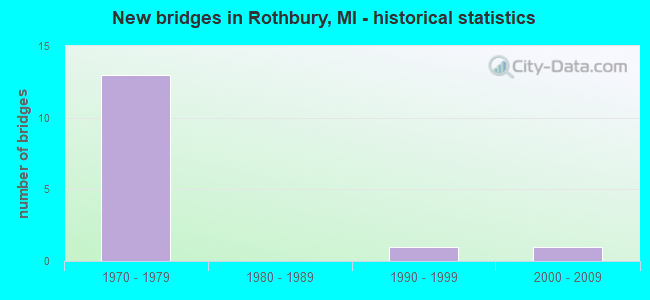
- New bridges - historical statistics
- 131970-1979
- 11990-1999
- 12000-2009


- Bridge Condition - Deck
- 42.9%Good
- 42.9%Satisfactory
- 14.3%Fair

- Bridge Condition - Superstructure
- 14.3%Very good
- 57.1%Good
- 28.6%Satisfactory

- Bridge Condition - Substructure
- 42.9%Good
- 57.1%Satisfactory

- Bridge Condition - Channel
- 50.0%Good
- 50.0%Satisfactory

- Bridge Condition - Culverts
- 50.0%Very good
- 50.0%Satisfactory
Find on map >> Show street view
Structure Number: 8325, Location: 2.5 MI S OF ROTHBURY (Lat: 43.476103, Lng: -86.343967), Route carried "on" structure: US 31, Year Built: 1974, Status: Open, Structure Length: 5.39m (17.68ft), Average Daily Traffic: 6,360 (year 2007), Truck Traffic: 9%, Average Future Daily Traffic: 7,766 (year 2018), Design Load: HS 25 or greater, Features Intersected: HART-MONTAGUE TRAIL
Minimum Vertical Clearance: 30.48m (100.00ft), Kilometerpoint: 0.653, Lanes on structure: 2, Base Highway Network: Yes (Inventory Route: 154, Subroute: 2), Owner: State Highway Agency, Approaching Roadway Width: 14.0m (45.9ft), Skew: 3 degrees, Material/Design: Steel, Design/Construction: Stringer/Multi-beam, Number Of Spans In Main Unit: 3, Length of Maximum Span: 19.2m (63.0ft), Curb-To-Curb Width: 13.1m (43.0ft), Out-to-Out Width: 13.5m (44.3ft)
Condition: Deck: Satisfactory, Superstructure: Satisfactory, Substructure: Satisfactory, Operating Rating: 77.1 metric tons, Method Used To Determine Operating Rating: Load Factor (LF) rating reported by rating factor (RF) method using MS18 loading, Inventory Rating: 46.0 metric tons, Method Used To Determine Inventory Rating: Load Factor (LF) rating reported by rating factor (RF) method using MS18 loading, Structural Evaluation: Equal to present minimum criteria, Deck Geometry: Superior to present desirable criteria, Approach Roadway Alignment: Equal to present desirable criteria, Designated Inspection Frequency: Every 24 months, Inspection Date: November 2021, Bridge Improvement Cost: $181,000, Roadway Improvement Cost: $14,000, Total Project Cost: $163,000, Deck Structure Type: Concrete Cast-file-Place, Wearing Surface/Protective System: Wearing Surface: Monolithic Concrete
Find on map >> Show street view
Structure Number: 8326, Location: 2.5 MI S OF ROTHBURY (Lat: 43.476642, Lng: -86.343981), Route carried "on" structure: US 31, Year Built: 1974, Status: Open, Structure Length: 5.30m (17.39ft), Average Daily Traffic: 6,360 (year 2007), Truck Traffic: 9%, Average Future Daily Traffic: 7,766 (year 2018), Design Load: HS 25 or greater, Features Intersected: HART-MONTAGUE TRAIL
Minimum Vertical Clearance: 30.48m (100.00ft), Kilometerpoint: 0.748, Lanes on structure: 2, Base Highway Network: Yes (Inventory Route: 154, Subroute: 3), Owner: State Highway Agency, Approaching Roadway Width: 14.0m (45.9ft), Skew: 3 degrees, Material/Design: Steel, Design/Construction: Stringer/Multi-beam, Number Of Spans In Main Unit: 3, Length of Maximum Span: 18.8m (61.7ft), Curb-To-Curb Width: 13.1m (43.0ft), Out-to-Out Width: 13.5m (44.3ft)
Condition: Deck: Satisfactory, Superstructure: Good, Substructure: Good, Operating Rating: 76.8 metric tons, Method Used To Determine Operating Rating: Load Factor (LF) rating reported by rating factor (RF) method using MS18 loading, Inventory Rating: 46.0 metric tons, Method Used To Determine Inventory Rating: Load Factor (LF) rating reported by rating factor (RF) method using MS18 loading, Structural Evaluation: Better than present minimum criteria, Deck Geometry: Superior to present desirable criteria, Approach Roadway Alignment: Equal to present desirable criteria, Designated Inspection Frequency: Every 24 months, Inspection Date: November 2021, Bridge Improvement Cost: $179,000, Roadway Improvement Cost: $14,000, Total Project Cost: $161,000, Deck Structure Type: Concrete Cast-file-Place, Wearing Surface/Protective System: Wearing Surface: Epoxy Overlay
Find on map >> Show street view
Structure Number: 8328, Location: 0.5 MI SW OF ROTHBURY (Lat: 43.493575, Lng: -86.370156), Route carried "on" structure: County highway 6429, Year Built: 1974, Status: Open, Structure Length: 11.46m (37.60ft), Average Daily Traffic: 550 (year 1988), Average Future Daily Traffic: 500 (year 1977), Design Load: H 20, Features Intersected: US-31, Facility Carried by Structure: WEBSTER RD
Minimum Vertical Clearance: 30.48m (100.00ft), Kilometerpoint: 3.747, Lanes on structure: 2, Lanes under structure: 4, Owner: State Highway Agency, Approaching Roadway Width: 12.8m (42.0ft), Skew: 1 degrees, Material/Design: Steel, Design/Construction: Stringer/Multi-beam, Number Of Spans In Main Unit: 3, Length of Maximum Span: 40.2m (131.9ft), Curb-To-Curb Width: 12.3m (40.4ft), Out-to-Out Width: 13.4m (44.0ft)
Condition: Deck: Good, Superstructure: Good, Substructure: Satisfactory, Operating Rating: 74.3 metric tons, Method Used To Determine Operating Rating: Load Factor (LF), Inventory Rating: 44.5 metric tons, Method Used To Determine Inventory Rating: Load Factor (LF), Structural Evaluation: Equal to present minimum criteria, Deck Geometry: Superior to present desirable criteria, Underclear: Better than present minimum criteria, Approach Roadway Alignment: Equal to present desirable criteria, Designated Inspection Frequency: Every 24 months, Inspection Date: November 2021, Bridge Improvement Cost: $359,000, Roadway Improvement Cost: $22,000, Total Project Cost: $261,000, Deck Structure Type: Concrete Cast-file-Place, Wearing Surface/Protective System: Wearing Surface: Monolithic Concrete
Find on map >> Show street view
Structure Number: 8329, Location: 1 MI W OF ROTHBURY (Lat: 43.508017, Lng: -86.373522), Route carried "on" structure: County highway 6410, Year Built: 1973, Year Reconstructed: 2013, Status: Open, Structure Length: 9.72m (31.89ft), Average Daily Traffic: 2,500 (year 2012), Truck Traffic: 4%, Average Future Daily Traffic: 3,090 (year 2033), Design Load: H 20, Features Intersected: US-31, Facility Carried by Structure: WINSTON RD
Minimum Vertical Clearance: 30.48m (100.00ft), Kilometerpoint: 3.605, Lanes on structure: 2, Lanes under structure: 4, Owner: State Highway Agency, Approaching Roadway Width: 13.4m (44.0ft), Skew: 2 degrees, Material/Design: Steel, Design/Construction: Stringer/Multi-beam, Number Of Spans In Main Unit: 4, Length of Maximum Span: 36.1m (118.4ft), Curb-To-Curb Width: 12.4m (40.7ft), Out-to-Out Width: 13.4m (44.0ft)
Condition: Deck: Good, Superstructure: Good, Substructure: Satisfactory, Operating Rating: 77.8 metric tons, Method Used To Determine Operating Rating: Load Factor (LF) rating reported by rating factor (RF) method using MS18 loading, Inventory Rating: 46.0 metric tons, Method Used To Determine Inventory Rating: Load Factor (LF) rating reported by rating factor (RF) method using MS18 loading, Structural Evaluation: Equal to present minimum criteria, Deck Geometry: Equal to present minimum criteria, Underclear: Better than present minimum criteria, Approach Roadway Alignment: Equal to present desirable criteria, Designated Inspection Frequency: Every 24 months, Inspection Date: July 2020, Deck Structure Type: Concrete Cast-file-Place, Wearing Surface/Protective System: Wearing Surface: Monolithic Concrete, Deck Protection: Epoxy Coated Reinforcing
Find on map >> Show street view
Structure Number: 833, Location: 2 MI SW OF NEW ERA (Lat: 43.533611, Lng: -86.385147), Route carried "on" structure: County highway , Year Built: 1973, Status: Open, Structure Length: 4.63m (15.19ft), Average Daily Traffic: 60 (year 2007), Average Future Daily Traffic: 66 (year 2022), Design Load: H 20, Features Intersected: US-31 SB, Facility Carried by Structure: PARK RD
Minimum Vertical Clearance: 30.48m (100.00ft), Kilometerpoint: 2.686, Lanes on structure: 2, Lanes under structure: 2, Owner: State Highway Agency, Approaching Roadway Width: 11.5m (37.7ft), Material/Design: Steel, Design/Construction: Stringer/Multi-beam, Number Of Spans In Main Unit: 1, Length of Maximum Span: 46.3m (151.9ft), Curb or Sidewalk Widths: Left: 0.2m (0.7ft), Right: 0.2m (0.7ft), Curb-To-Curb Width: 11.1m (36.4ft), Out-to-Out Width: 12.3m (40.4ft)
Condition: Deck: Satisfactory, Superstructure: Good, Substructure: Good, Operating Rating: 97.2 metric tons, Method Used To Determine Operating Rating: Load Factor (LF) rating reported by rating factor (RF) method using MS18 loading, Inventory Rating: 65.8 metric tons, Method Used To Determine Inventory Rating: Load Factor (LF) rating reported by rating factor (RF) method using MS18 loading, Structural Evaluation: Better than present minimum criteria, Deck Geometry: Superior to present desirable criteria, Underclear: Better than present minimum criteria, Approach Roadway Alignment: Equal to present desirable criteria, Designated Inspection Frequency: Every 24 months, Inspection Date: July 2020, Deck Structure Type: Concrete Cast-file-Place, Wearing Surface/Protective System: Wearing Surface: Monolithic Concrete
Find on map >> Show street view
Structure Number: 8331, Location: 2 MI SW OF NEW ERA (Lat: 43.533564, Lng: -86.383689), Route carried "on" structure: County highway , Year Built: 1973, Status: Open, Structure Length: 4.63m (15.19ft), Average Daily Traffic: 60 (year 1988), Average Future Daily Traffic: 69 (year 2008), Design Load: H 20, Features Intersected: US-31 NB, Facility Carried by Structure: PARK RD
Minimum Vertical Clearance: 30.48m (100.00ft), Kilometerpoint: 2.805, Lanes on structure: 2, Lanes under structure: 2, Owner: State Highway Agency, Approaching Roadway Width: 11.5m (37.7ft), Material/Design: Steel, Design/Construction: Stringer/Multi-beam, Number Of Spans In Main Unit: 1, Length of Maximum Span: 46.3m (151.9ft), Curb-To-Curb Width: 11.1m (36.4ft), Out-to-Out Width: 12.3m (40.4ft)
Condition: Deck: Good, Superstructure: Very good, Substructure: Good, Operating Rating: 91.0 metric tons, Method Used To Determine Operating Rating: Load Factor (LF) rating reported by rating factor (RF) method using MS18 loading, Inventory Rating: 54.4 metric tons, Method Used To Determine Inventory Rating: Load Factor (LF) rating reported by rating factor (RF) method using MS18 loading, Structural Evaluation: Better than present minimum criteria, Deck Geometry: Superior to present desirable criteria, Underclear: Better than present minimum criteria, Approach Roadway Alignment: Equal to present desirable criteria, Designated Inspection Frequency: Every 24 months, Inspection Date: July 2020, Bridge Improvement Cost: $151,000, Roadway Improvement Cost: $8,000, Total Project Cost: $93,000, Deck Structure Type: Concrete Cast-file-Place, Wearing Surface/Protective System: Wearing Surface: Monolithic Concrete
Find on map >> Show street view
Structure Number: 8333, Location: 1.5 MI S OF ROTHBURY (Lat: 43.477967, Lng: -86.347372), Route carried "on" structure: US 31, Year Built: 1974, Status: Open, Structure Length: 3.35m (10.99ft), Average Daily Traffic: 6,360 (year 2007), Truck Traffic: 9%, Average Future Daily Traffic: 7,766 (year 2018), Design Load: HS 25 or greater, Features Intersected: OCEANA DRIVE (OLD US-31)
Minimum Vertical Clearance: 30.48m (100.00ft), Kilometerpoint: 1.061, Lanes on structure: 2, Lanes under structure: 2, Base Highway Network: Yes (Inventory Route: 154, Subroute: 3), Owner: State Highway Agency, Approaching Roadway Width: 13.1m (43.0ft), Skew: 2 degrees, Material/Design: Steel, Design/Construction: Stringer/Multi-beam, Number Of Spans In Main Unit: 1, Length of Maximum Span: 33.5m (109.9ft), Curb-To-Curb Width: 13.0m (42.7ft), Out-to-Out Width: 13.5m (44.3ft)
Condition: Deck: Fair, Superstructure: Satisfactory, Substructure: Satisfactory, Operating Rating: 86.8 metric tons, Method Used To Determine Operating Rating: Load Factor (LF) rating reported by rating factor (RF) method using MS18 loading, Inventory Rating: 51.8 metric tons, Method Used To Determine Inventory Rating: Load Factor (LF) rating reported by rating factor (RF) method using MS18 loading, Structural Evaluation: Equal to present minimum criteria, Deck Geometry: Superior to present desirable criteria, Underclear: Equal to present minimum criteria, Approach Roadway Alignment: Equal to present desirable criteria, Length Of Structure Improvement: 3.35m (10.99ft), Designated Inspection Frequency: Every 24 months, Inspection Date: November 2021, Bridge Improvement Cost: $81,000, Roadway Improvement Cost: $4,000, Total Project Cost: $50,000, Deck Structure Type: Concrete Cast-file-Place, Wearing Surface/Protective System: Wearing Surface: Epoxy Overlay
Find on map >> Show street view
Structure Number: 12967, Location: GRANT TWP SEC 27 (Lat: 43.496867, Lng: -86.328142), Route carried "on" structure: County highway , Year Built: 1999, Status: Open, Structure Length: 0.72m (2.36ft), Average Daily Traffic: 270 (year 2004), Truck Traffic: 2%, Average Future Daily Traffic: 350 (year 2024), Design Load: HS 20, Features Intersected: CARLTON CREEK, Facility Carried by Structure: 92ND AVE
Minimum Vertical Clearance: 30.48m (100.00ft), Kilometerpoint: 0.056, Lanes on structure: 2, Owner: County Highway Agency, Approaching Roadway Width: 8.2m (26.9ft), Skew: 2 degrees, Material/Design: Steel, Design/Construction: Culvert, Number Of Spans In Main Unit: 2, Length of Maximum Span: 3.2m (10.5ft)
Condition: Channel: Satisfactory, Culverts: Satisfactory, Operating Rating: 34.3 metric tons, Method Used To Determine Operating Rating: Load Factor (LF) rating reported by rating factor (RF) method using MS18 loading, Inventory Rating: 20.7 metric tons, Method Used To Determine Inventory Rating: Load Factor (LF) rating reported by rating factor (RF) method using MS18 loading, Structural Evaluation: Equal to present minimum criteria, Waterway Adequacy: Equal to present minimum criteria, Approach Roadway Alignment: Better than present minimum criteria, Designated Inspection Frequency: Every 24 months, Inspection Date: August 2020, Wearing Surface/Protective System: Wearing Surface: Bituminous
Find on map >> Show street view
Structure Number: 13151, Location: 0.25 MI W OF 72ND AVE (Lat: 43.472167, Lng: -86.381364), Route carried "on" structure: County highway , Year Built: 2001, Status: Open, Structure Length: 0.77m (2.53ft), Average Daily Traffic: 150 (year 2005), Truck Traffic: 2%, Average Future Daily Traffic: 200 (year 2025), Design Load: HS 20, Features Intersected: FLOWER CREEK, Facility Carried by Structure: SKEELS ROAD
Minimum Vertical Clearance: 30.48m (100.00ft), Kilometerpoint: 2.879, Lanes on structure: 2, Owner: County Highway Agency, Approaching Roadway Width: 7.7m (25.3ft), Material/Design: Steel, Design/Construction: Culvert, Number Of Spans In Main Unit: 1, Length of Maximum Span: 7.4m (24.3ft), Curb-To-Curb Width: 7.7m (25.3ft), Out-to-Out Width: 9.1m (29.9ft)
Condition: Channel: Good, Culverts: Very good, Operating Rating: 54.2 metric tons, Method Used To Determine Operating Rating: Field evaluation and documented engineering judgment, Inventory Rating: 41.8 metric tons, Method Used To Determine Inventory Rating: Field evaluation and documented engineering judgment, Structural Evaluation: Equal to present desirable criteria, Deck Geometry: Somewhat better than minimum adequacy, Waterway Adequacy: Equal to present desirable criteria, Approach Roadway Alignment: Better than present minimum criteria, Designated Inspection Frequency: Every 24 months, Inspection Date: August 2020, Wearing Surface/Protective System: Wearing Surface: Bituminous
Find on map >> Show street view
Structure Number: 8327, Location: 1.5 MI S OF ROTHBURY (Lat: 43.477594, Lng: -86.347358), Route carried "under" structure: Alternate US 31, Year Built: 1974, Structure Length: 0. m, Average Daily Traffic: 4,900 (year 1995), Truck Traffic: 5%, Features Intersected: OCEANA DRIVE (OLD US-31)
Minimum Vertical Clearance: 4.95m (16.24ft), Kilometerpoint: 0.665, Lanes on structure: 2, Lanes under structure: 2, Material/Design: Steel, Design/Construction: Stringer/Multi-beam, Length of Maximum Span: 33.5m (109.9ft)
Find on map >> Show street view
Structure Number: 8328, Location: 0.5 MI SW OF ROTHBURY (Lat: 43.493575, Lng: -86.370156), Route carried "under" structure: US 31, Year Built: 1974, Structure Length: 0. m, Average Daily Traffic: 12,720 (year 2007), Truck Traffic: 9%, Features Intersected: US-31, Facility Carried by Structure: WEBSTER RD
Minimum Vertical Clearance: 5.18m (16.99ft), Kilometerpoint: 3.694, Lanes on structure: 2, Lanes under structure: 4, Material/Design: Steel, Design/Construction: Stringer/Multi-beam, Length of Maximum Span: 40.2m (131.9ft)
Find on map >> Show street view
Structure Number: 8329, Location: 1 MI W OF ROTHBURY (Lat: 43.508017, Lng: -86.373522), Route carried "under" structure: US 31, Year Built: 1973, Structure Length: 0. m, Average Daily Traffic: 11,000 (year 2013), Truck Traffic: 10%, Features Intersected: US-31, Facility Carried by Structure: WINSTON RD
Minimum Vertical Clearance: 5.08m (16.67ft), Kilometerpoint: 5.327, Lanes on structure: 2, Lanes under structure: 4, Material/Design: Steel, Design/Construction: Stringer/Multi-beam, Length of Maximum Span: 36.1m (118.4ft)
Find on map >> Show street view
Structure Number: 833, Location: 2 MI SW OF NEW ERA (Lat: 43.533611, Lng: -86.385147), Route carried "under" structure: US 31, Year Built: 1973, Structure Length: 0. m, Average Daily Traffic: 5,611 (year 2007), Truck Traffic: 9%, Features Intersected: US-31 SB, Facility Carried by Structure: PARK RD
Minimum Vertical Clearance: 4.98m (16.34ft), Kilometerpoint: 8.520, Lanes on structure: 2, Lanes under structure: 2, Material/Design: Steel, Design/Construction: Stringer/Multi-beam, Length of Maximum Span: 46.3m (151.9ft)
Find on map >> Show street view
Structure Number: 8331, Location: 2 MI SW OF NEW ERA (Lat: 43.533564, Lng: -86.383689), Route carried "under" structure: US 31, Year Built: 1973, Structure Length: 0. m, Average Daily Traffic: 5,611 (year 2007), Truck Traffic: 9%, Features Intersected: US-31 NB, Facility Carried by Structure: PARK RD
Minimum Vertical Clearance: 30+ m (98+ ft), Kilometerpoint: 8.472, Lanes on structure: 2, Lanes under structure: 2, Material/Design: Steel, Design/Construction: Stringer/Multi-beam, Length of Maximum Span: 46.3m (151.9ft)
Find on map >> Show street view
Structure Number: 8333, Location: 1.5 MI S OF ROTHBURY (Lat: 43.477967, Lng: -86.347372), Route carried "under" structure: Alternate US 31, Year Built: 1974, Structure Length: 0. m, Average Daily Traffic: 4,600 (year 1995), Truck Traffic: 12%, Features Intersected: OCEANA DRIVE (OLD US-31)
Minimum Vertical Clearance: 4.72m (15.49ft), Kilometerpoint: 0.705, Lanes on structure: 2, Lanes under structure: 2, Material/Design: Steel, Design/Construction: Stringer/Multi-beam, Length of Maximum Span: 33.5m (109.9ft)