Bridge Statistics for Roseville, Michigan (MI)
Condition, Traffic, Stress, Structural Evaluation, Project Costs
- National Bridge Inventory (NBI) Statistics
- 36Number of bridges
- 427ft / 130mTotal length
- $1,653,000Total costs
- 2,133,723Total average daily traffic
- 116,310Total average daily truck traffic
- National Bridge Inventory (NBI) Registered Bridges for Roseville
- No street view available for this location
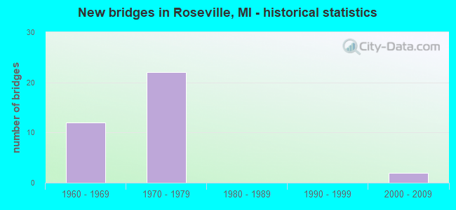
- New bridges - historical statistics
- 121960-1969
- 221970-1979
- 22000-2009
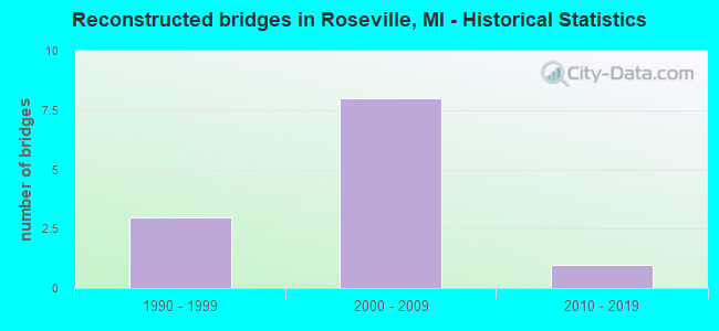
- Reconstructed bridges - Historical Statistics
- 31990-1999
- 82000-2009
- 12010-2019
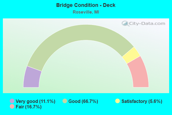
- Bridge Condition - Deck
- 11.1%Very good
- 66.7%Good
- 5.6%Satisfactory
- 16.7%Fair
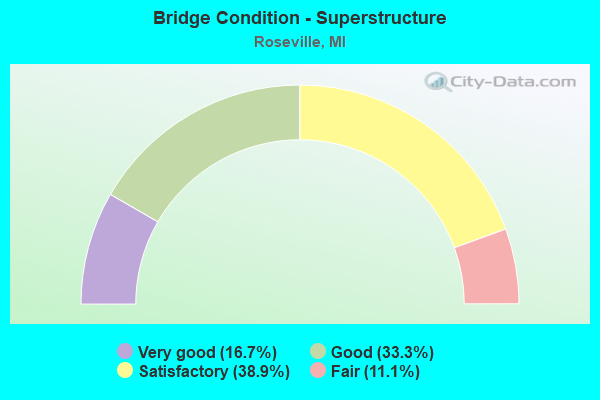
- Bridge Condition - Superstructure
- 16.7%Very good
- 33.3%Good
- 38.9%Satisfactory
- 11.1%Fair
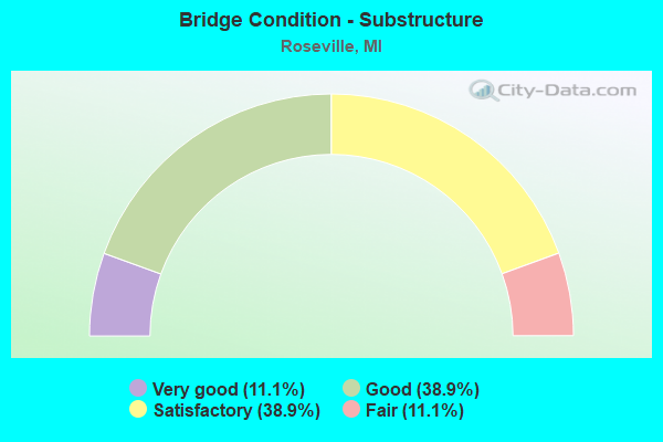
- Bridge Condition - Substructure
- 11.1%Very good
- 38.9%Good
- 38.9%Satisfactory
- 11.1%Fair

- Bridge Condition - Channel
- 50.0%Very good
- 50.0%Satisfactory
Find on map >> Show street view
Structure Number: 612, Location: 1.5 MI S OF KAWKAWLIN (Lat: 43.640011, Lng: -83.974450), Route carried "on" structure: Interstate 75, Year Built: 1968, Status: Open, Structure Length: 5.76m (18.90ft), Average Daily Traffic: 11,225 (year 2019), Truck Traffic: 9%, Average Future Daily Traffic: 12,909 (year 2039), Design Load: HS 20+Mod, Features Intersected: KAWKAWLIN RIVER
Minimum Vertical Clearance: 30.48m (100.00ft), Kilometerpoint: 13.958, Lanes on structure: 2, Base Highway Network: Yes (Inventory Route: 76, Subroute: 1), Owner: State Highway Agency, Approaching Roadway Width: 12.2m (40.0ft), Material/Design: Prestressed concrete, Design/Construction: Stringer/Multi-beam, Number Of Spans In Main Unit: 3, Length of Maximum Span: 19.2m (63.0ft), Curb-To-Curb Width: 11.8m (38.7ft), Out-to-Out Width: 12.8m (42.0ft)
Condition: Deck: Good, Superstructure: Fair, Substructure: Good, Channel: Very good, Operating Rating: 71.9 metric tons, Method Used To Determine Operating Rating: Load Factor (LF) rating reported by rating factor (RF) method using MS18 loading, Inventory Rating: 36.9 metric tons, Method Used To Determine Inventory Rating: Load Factor (LF) rating reported by rating factor (RF) method using MS18 loading, Structural Evaluation: Somewhat better than minimum adequacy, Deck Geometry: Equal to present minimum criteria, Waterway Adequacy: Equal to present desirable criteria, Approach Roadway Alignment: Equal to present desirable criteria, Designated Inspection Frequency: Every 24 months, Inspection Date: October 2021, Deck Structure Type: Concrete Cast-file-Place, Wearing Surface/Protective System: Wearing Surface: Latex Concrete, Deck Protection: Epoxy Coated Reinforcing
Find on map >> Show street view
Structure Number: 616, Location: 3.5 MI NW OF PINCONNING (Lat: 43.908642, Lng: -84.020086), Route carried "on" structure: Interstate 75, Year Built: 1968, Year Reconstructed: 2011, Status: Open, Structure Length: 2.49m (8.17ft), Average Daily Traffic: 13,735 (year 2007), Truck Traffic: 7%, Average Future Daily Traffic: 16,605 (year 2030), Design Load: HS 20+Mod, Features Intersected: SAGANING RIVER
Minimum Vertical Clearance: 30.48m (100.00ft), Kilometerpoint: 45.251, Lanes on structure: 2, Base Highway Network: Yes (Inventory Route: 76, Subroute: 1), Owner: State Highway Agency, Approaching Roadway Width: 12.8m (42.0ft), Skew: 1 degrees, Material/Design: Prestressed concrete, Design/Construction: Stringer/Multi-beam, Number Of Spans In Main Unit: 2, Length of Maximum Span: 11.9m (39.0ft), Curb-To-Curb Width: 12.8m (42.0ft), Out-to-Out Width: 13.7m (44.9ft)
Condition: Deck: Good, Superstructure: Good, Substructure: Very good, Channel: Satisfactory, Operating Rating: 63.8 metric tons, Method Used To Determine Operating Rating: Load Factor (LF) rating reported by rating factor (RF) method using MS18 loading, Inventory Rating: 38.2 metric tons, Method Used To Determine Inventory Rating: Load Factor (LF) rating reported by rating factor (RF) method using MS18 loading, Structural Evaluation: Better than present minimum criteria, Deck Geometry: Equal to present desirable criteria, Waterway Adequacy: Equal to present desirable criteria, Approach Roadway Alignment: Equal to present desirable criteria, Designated Inspection Frequency: Every 24 months, Inspection Date: May 2020, Deck Structure Type: Concrete Cast-file-Place, Wearing Surface/Protective System: Wearing Surface: Latex Concrete
Find on map >> Show street view
Structure Number: 6071, Location: IN ROSEVILLE (13 MI RD) (Lat: 42.524764, Lng: -82.916186), Route carried "on" structure: Ramp Interstate 94, Year Built: 1964, Year Reconstructed: 2003, Status: Open, Structure Length: 4.06m (13.32ft), Average Daily Traffic: 17,021 (year 2007), Truck Traffic: 4%, Average Future Daily Traffic: 18,074 (year 2018), Design Load: HS 25 or greater, Features Intersected: 13 MILE RD
Minimum Vertical Clearance: 30.48m (100.00ft), Kilometerpoint: 0.637, Lanes on structure: 1, Lanes under structure: 4, Owner: State Highway Agency, Approaching Roadway Width: 12.8m (42.0ft), Skew: 10 degrees, Material/Design: Steel, Design/Construction: Stringer/Multi-beam, Number Of Spans In Main Unit: 3, Length of Maximum Span: 17.2m (56.4ft), Curb-To-Curb Width: 12.9m (42.3ft), Out-to-Out Width: 13.9m (45.6ft)
Condition: Deck: Good, Superstructure: Very good, Substructure: Good, Operating Rating: 98.4 metric tons, Method Used To Determine Operating Rating: Load Factor (LF), Inventory Rating: 58.9 metric tons, Method Used To Determine Inventory Rating: Load Factor (LF), Structural Evaluation: Better than present minimum criteria, Deck Geometry: Superior to present desirable criteria, Underclear: Equal to present minimum criteria, Approach Roadway Alignment: Better than present minimum criteria, Designated Inspection Frequency: Every 24 months, Inspection Date: June 2021, Deck Structure Type: Concrete Cast-file-Place, Wearing Surface/Protective System: Wearing Surface: Monolithic Concrete, Deck Protection: Epoxy Coated Reinforcing
Find on map >> Show street view
Structure Number: 6072, Location: IN ROSEVILLE (13 MI RD) (Lat: 42.524758, Lng: -82.916447), Route carried "on" structure: Ramp Interstate 94, Year Built: 1964, Year Reconstructed: 2003, Status: Open, Structure Length: 4.07m (13.35ft), Average Daily Traffic: 17,021 (year 2007), Truck Traffic: 4%, Average Future Daily Traffic: 18,074 (year 2018), Design Load: HS 25 or greater, Features Intersected: 13 MILE RD
Minimum Vertical Clearance: 30.48m (100.00ft), Kilometerpoint: 0.483, Lanes on structure: 2, Lanes under structure: 4, Owner: State Highway Agency, Approaching Roadway Width: 12.8m (42.0ft), Skew: 10 degrees, Material/Design: Steel, Design/Construction: Stringer/Multi-beam, Number Of Spans In Main Unit: 3, Length of Maximum Span: 17.3m (56.8ft), Curb-To-Curb Width: 12.9m (42.3ft), Out-to-Out Width: 13.9m (45.6ft)
Condition: Deck: Good, Superstructure: Very good, Substructure: Good, Operating Rating: 96.7 metric tons, Method Used To Determine Operating Rating: Load Factor (LF), Inventory Rating: 57.9 metric tons, Method Used To Determine Inventory Rating: Load Factor (LF), Structural Evaluation: Better than present minimum criteria, Deck Geometry: Superior to present desirable criteria, Underclear: Equal to present minimum criteria, Approach Roadway Alignment: Better than present minimum criteria, Designated Inspection Frequency: Every 24 months, Inspection Date: June 2021, Deck Structure Type: Concrete Cast-file-Place, Wearing Surface/Protective System: Wearing Surface: Monolithic Concrete, Deck Protection: Epoxy Coated Reinforcing
Find on map >> Show street view
Structure Number: 6115, Location: IN ROSEVILLE (Lat: 42.494569, Lng: -82.947689), Route carried "on" structure: City street , Year Built: 1972, Year Reconstructed: 2005, Status: Open, Structure Length: 6.10m (20.01ft), Average Daily Traffic: 12,000 (year 2007), Average Future Daily Traffic: 13,200 (year 2022), Design Load: H 15, Features Intersected: I-696, Facility Carried by Structure: GROVELAND AVE
Minimum Vertical Clearance: 30.48m (100.00ft), Kilometerpoint: 1.392, Lanes on structure: 4, Lanes under structure: 8, Owner: State Highway Agency, Approaching Roadway Width: 15.8m (51.8ft), Material/Design: Steel continuous, Design/Construction: Stringer/Multi-beam, Number Of Spans In Main Unit: 2, Length of Maximum Span: 30.5m (100.1ft), Curb or Sidewalk Widths: Left: 1.8m (5.9ft), Right: 1.8m (5.9ft), Curb-To-Curb Width: 15.8m (51.8ft), Out-to-Out Width: 20.2m (66.3ft)
Condition: Deck: Good, Superstructure: Good, Substructure: Satisfactory, Operating Rating: 73.9 metric tons, Method Used To Determine Operating Rating: Load Factor (LF), Inventory Rating: 44.3 metric tons, Method Used To Determine Inventory Rating: Load Factor (LF), Structural Evaluation: Equal to present minimum criteria, Deck Geometry: Meets minimum limits, Underclear: Somewhat better than minimum adequacy, Approach Roadway Alignment: Equal to present desirable criteria, Length Of Structure Improvement: 6.10m (20.01ft), Designated Inspection Frequency: Every 24 months, Inspection Date: September 2021, Bridge Improvement Cost: $161,000, Roadway Improvement Cost: $9,000, Total Project Cost: $107,000, Deck Structure Type: Concrete Cast-file-Place, Wearing Surface/Protective System: Wearing Surface: Monolithic Concrete, Deck Protection: Epoxy Coated Reinforcing
Find on map >> Show street view
Structure Number: 6116, Location: IN ROSEVILLE (Lat: 42.494428, Lng: -82.938253), Route carried "on" structure: State highway 3, Year Built: 1972, Year Reconstructed: 2006, Status: Open, Structure Length: 5.79m (19.00ft), Average Daily Traffic: 27,333 (year 2007), Truck Traffic: 2%, Average Future Daily Traffic: 27,776 (year 2018), Design Load: HS 20, Features Intersected: I-696
Minimum Vertical Clearance: 30.48m (100.00ft), Kilometerpoint: 5.504, Lanes on structure: 3, Lanes under structure: 6, Base Highway Network: Yes (Inventory Route: 80, Subroute: 6), Owner: State Highway Agency, Approaching Roadway Width: 16.1m (52.8ft), Skew: 12 degrees, Material/Design: Steel, Design/Construction: Stringer/Multi-beam, Number Of Spans In Main Unit: 2, Length of Maximum Span: 28.9m (94.8ft), Curb or Sidewalk Widths: Left: 0.0m, Right: 3.0m (9.8ft), Curb-To-Curb Width: 16.3m (53.5ft), Out-to-Out Width: 20.0m (65.6ft)
Condition: Deck: Good, Superstructure: Satisfactory, Substructure: Fair, Operating Rating: 91.4 metric tons, Method Used To Determine Operating Rating: Load Factor (LF) rating reported by rating factor (RF) method using MS18 loading, Inventory Rating: 54.8 metric tons, Method Used To Determine Inventory Rating: Load Factor (LF) rating reported by rating factor (RF) method using MS18 loading, Structural Evaluation: Somewhat better than minimum adequacy, Deck Geometry: Better than present minimum criteria, Underclear: Equal to present minimum criteria, Approach Roadway Alignment: Equal to present desirable criteria, Length Of Structure Improvement: 5.79m (19.00ft), Designated Inspection Frequency: Every 24 months, Other Special Inspection Frequency: Every 12 months, Inspection Date: September 2021, Other Special Inspection Date: September 2021, Bridge Improvement Cost: $194,000, Roadway Improvement Cost: $7,000, Total Project Cost: $79,000, Deck Structure Type: Concrete Cast-file-Place, Wearing Surface/Protective System: Wearing Surface: Monolithic Concrete, Deck Protection: Epoxy Coated Reinforcing
Find on map >> Show street view
Structure Number: 6117, Location: IN ROSEVILLE (Lat: 42.494436, Lng: -82.938692), Route carried "on" structure: State highway 3, Year Built: 1972, Year Reconstructed: 2006, Status: Open, Structure Length: 5.79m (19.00ft), Average Daily Traffic: 27,333 (year 2007), Truck Traffic: 3%, Average Future Daily Traffic: 61,700 (year 2025), Design Load: HS 20, Features Intersected: I-696
Minimum Vertical Clearance: 30.48m (100.00ft), Kilometerpoint: 5.448, Lanes on structure: 3, Lanes under structure: 6, Base Highway Network: Yes (Inventory Route: 420, Subroute: 3), Owner: State Highway Agency, Approaching Roadway Width: 16.1m (52.8ft), Skew: 12 degrees, Material/Design: Steel, Design/Construction: Stringer/Multi-beam, Number Of Spans In Main Unit: 2, Length of Maximum Span: 29.0m (95.1ft), Curb or Sidewalk Widths: Left: 3.0m (9.8ft), Right: 0.0m, Curb-To-Curb Width: 16.2m (53.1ft), Out-to-Out Width: 20.0m (65.6ft)
Condition: Deck: Good, Superstructure: Satisfactory, Substructure: Good, Operating Rating: 92.3 metric tons, Method Used To Determine Operating Rating: Load Factor (LF) rating reported by rating factor (RF) method using MS18 loading, Inventory Rating: 55.1 metric tons, Method Used To Determine Inventory Rating: Load Factor (LF) rating reported by rating factor (RF) method using MS18 loading, Structural Evaluation: Equal to present minimum criteria, Deck Geometry: Better than present minimum criteria, Underclear: Equal to present minimum criteria, Approach Roadway Alignment: Equal to present desirable criteria, Length Of Structure Improvement: 5.79m (19.00ft), Designated Inspection Frequency: Every 24 months, Inspection Date: September 2021, Bridge Improvement Cost: $194,000, Roadway Improvement Cost: $6,000, Total Project Cost: $71,000, Deck Structure Type: Concrete Cast-file-Place, Wearing Surface/Protective System: Wearing Surface: Monolithic Concrete, Deck Protection: Epoxy Coated Reinforcing
Find on map >> Show street view
Structure Number: 6118, Location: IN ROSEVILLE (Lat: 42.494439, Lng: -82.931008), Route carried "on" structure: City street , Year Built: 1972, Year Reconstructed: 2008, Status: Open, Structure Length: 5.97m (19.59ft), Average Daily Traffic: 3,000 (year 1990), Truck Traffic: 7%, Average Future Daily Traffic: 3,300 (year 2015), Design Load: H 15, Features Intersected: I-696, Facility Carried by Structure: NIEMAN ST
Minimum Vertical Clearance: 30.48m (100.00ft), Kilometerpoint: 0.264, Lanes on structure: 2, Lanes under structure: 8, Owner: State Highway Agency, Approaching Roadway Width: 10.0m (32.8ft), Material/Design: Steel continuous, Design/Construction: Stringer/Multi-beam, Number Of Spans In Main Unit: 2, Length of Maximum Span: 29.9m (98.1ft), Curb or Sidewalk Widths: Left: 1.8m (5.9ft), Right: 1.8m (5.9ft), Curb-To-Curb Width: 10.1m (33.1ft), Out-to-Out Width: 14.4m (47.2ft)
Condition: Deck: Good, Superstructure: Good, Substructure: Satisfactory, Operating Rating: 62.3 metric tons, Method Used To Determine Operating Rating: Load Factor (LF), Inventory Rating: 37.4 metric tons, Method Used To Determine Inventory Rating: Load Factor (LF), Structural Evaluation: Equal to present minimum criteria, Deck Geometry: Meets minimum limits, Underclear: Somewhat better than minimum adequacy, Approach Roadway Alignment: Equal to present desirable criteria, Length Of Structure Improvement: 5.98m (19.62ft), Designated Inspection Frequency: Every 24 months, Inspection Date: April 2021, Bridge Improvement Cost: $118,000, Roadway Improvement Cost: $7,000, Total Project Cost: $80,000, Deck Structure Type: Concrete Cast-file-Place, Wearing Surface/Protective System: Wearing Surface: Monolithic Concrete, Deck Protection: Epoxy Coated Reinforcing
Find on map >> Show street view
Structure Number: 6119, Location: IN ROSEVILLE (Lat: 42.494689, Lng: -82.923950), Route carried "on" structure: ServiceCity street , Year Built: 1972, Year Reconstructed: 2008, Status: Open, Structure Length: 8.67m (28.44ft), Average Daily Traffic: 3,500 (year 1975), Truck Traffic: 3%, Average Future Daily Traffic: 3,500 (year 1977), Design Load: HS 20, Features Intersected: I-696, Facility Carried by Structure: SOUTH SERVICE RD
Minimum Vertical Clearance: 30.48m (100.00ft), Kilometerpoint: 13.693, Lanes on structure: 2, Lanes under structure: 4, Owner: State Highway Agency, Approaching Roadway Width: 8.5m (27.9ft), Skew: 6 degrees, Material/Design: Steel, Design/Construction: Stringer/Multi-beam, Number Of Spans In Main Unit: 3, Length of Maximum Span: 55.2m (181.1ft), Curb or Sidewalk Widths: Left: 0.0m, Right: 1.8m (5.9ft), Curb-To-Curb Width: 9.0m (29.5ft), Out-to-Out Width: 11.6m (38.1ft)
Condition: Deck: Very good, Superstructure: Fair, Substructure: Satisfactory, Operating Rating: 81.6 metric tons, Method Used To Determine Operating Rating: Load Factor (LF) rating reported by rating factor (RF) method using MS18 loading, Inventory Rating: 48.9 metric tons, Method Used To Determine Inventory Rating: Load Factor (LF) rating reported by rating factor (RF) method using MS18 loading, Structural Evaluation: Somewhat better than minimum adequacy, Deck Geometry: Meets minimum limits, Underclear: Equal to present minimum criteria, Approach Roadway Alignment: Equal to present desirable criteria, Length Of Structure Improvement: 8.69m (28.51ft), Designated Inspection Frequency: Every 24 months, Inspection Date: April 2021, Bridge Improvement Cost: $302,000, Roadway Improvement Cost: $13,000, Total Project Cost: $155,000, Deck Structure Type: Concrete Cast-file-Place, Wearing Surface/Protective System: Wearing Surface: Monolithic Concrete, Deck Protection: Epoxy Coated Reinforcing
Find on map >> Show street view
Structure Number: 612, Location: IN ROSEVILLE (Lat: 42.495372, Lng: -82.924092), Route carried "on" structure: ServiceCity street , Year Built: 1972, Year Reconstructed: 2008, Status: Open, Structure Length: 7.59m (24.90ft), Average Daily Traffic: 3,676 (year 2010), Average Future Daily Traffic: 4,044 (year 2025), Design Load: HS 20, Features Intersected: I-696, Facility Carried by Structure: NORTH SERVICE RD
Minimum Vertical Clearance: 30.48m (100.00ft), Kilometerpoint: 13.635, Lanes on structure: 2, Lanes under structure: 3, Owner: State Highway Agency, Approaching Roadway Width: 8.5m (27.9ft), Skew: 5 degrees, Material/Design: Steel, Design/Construction: Stringer/Multi-beam, Number Of Spans In Main Unit: 3, Length of Maximum Span: 46.6m (152.9ft), Curb or Sidewalk Widths: Left: 1.8m (5.9ft), Right: 0.0m, Curb-To-Curb Width: 9.0m (29.5ft), Out-to-Out Width: 11.6m (38.1ft)
Condition: Deck: Good, Superstructure: Satisfactory, Substructure: Satisfactory, Operating Rating: 61.3 metric tons, Method Used To Determine Operating Rating: Load Factor (LF), Inventory Rating: 36.8 metric tons, Method Used To Determine Inventory Rating: Load Factor (LF), Structural Evaluation: Equal to present minimum criteria, Deck Geometry: Meets minimum limits, Underclear: Somewhat better than minimum adequacy, Approach Roadway Alignment: Equal to present desirable criteria, Length Of Structure Improvement: 7.59m (24.90ft), Designated Inspection Frequency: Every 24 months, Inspection Date: April 2021, Bridge Improvement Cost: $171,000, Roadway Improvement Cost: $10,000, Total Project Cost: $115,000, Deck Structure Type: Concrete Cast-file-Place, Wearing Surface/Protective System: Wearing Surface: Latex Concrete
Find on map >> Show street view
Structure Number: 6121, Location: @ ROSEVILLE & ST CLAIR SH (Lat: 42.495556, Lng: -82.917700), Route carried "on" structure: Ramp Interstate 696, Year Built: 1972, Year Reconstructed: 2010, Status: Open, Structure Length: 34.22m (112.27ft), Average Daily Traffic: 22,900 (year 2009), Truck Traffic: 7%, Average Future Daily Traffic: 23,120 (year 2011), Design Load: HS 20+Mod, Features Intersected: I-94, 11 MI RD & RAMPS
Minimum Vertical Clearance: 30+ m (98+ ft), Kilometerpoint: 0.407, Lanes on structure: 2, Lanes under structure: 15, Owner: State Highway Agency, Approaching Roadway Width: 13.7m (44.9ft), Skew: 5 degrees, Material/Design: Steel, Design/Construction: Stringer/Multi-beam, Number Of Spans In Main Unit: 13, Length of Maximum Span: 51.3m (168.3ft), Curb-To-Curb Width: 13.0m (42.7ft), Out-to-Out Width: 14.0m (45.9ft)
Condition: Deck: Good, Superstructure: Good, Substructure: Good, Operating Rating: 71.6 metric tons, Method Used To Determine Operating Rating: Load Factor (LF) rating reported by rating factor (RF) method using MS18 loading, Inventory Rating: 42.8 metric tons, Method Used To Determine Inventory Rating: Load Factor (LF) rating reported by rating factor (RF) method using MS18 loading, Structural Evaluation: Better than present minimum criteria, Deck Geometry: Superior to present desirable criteria, Underclear: Somewhat better than minimum adequacy, Approach Roadway Alignment: Equal to present desirable criteria, Length Of Structure Improvement: 34.24m (112.34ft), Designated Inspection Frequency: Every 24 months, Inspection Date: June 2021, Bridge Improvement Cost: $1,142,000, Roadway Improvement Cost: $65,000, Total Project Cost: $762,000, Deck Structure Type: Concrete Cast-file-Place, Wearing Surface/Protective System: Wearing Surface: Monolithic Concrete, Deck Protection: Epoxy Coated Reinforcing
Find on map >> Show street view
Structure Number: 6122, Location: IN ROSEVILLE (Lat: 42.495103, Lng: -82.919439), Route carried "on" structure: ServiceInterstate 696, Year Built: 1972, Year Reconstructed: 2008, Status: Open, Structure Length: 4.48m (14.70ft), Average Daily Traffic: 8,500 (year 1975), Truck Traffic: 3%, Average Future Daily Traffic: 8,500 (year 1977), Design Load: HS 20, Features Intersected: I-696 RAMP N TO W
Minimum Vertical Clearance: 30.48m (100.00ft), Kilometerpoint: 0.237, Lanes on structure: 4, Lanes under structure: 2, Owner: State Highway Agency, Approaching Roadway Width: 28.6m (93.8ft), Skew: 34 degrees, Material/Design: Steel, Design/Construction: Stringer/Multi-beam, Number Of Spans In Main Unit: 3, Length of Maximum Span: 27.1m (88.9ft), Curb or Sidewalk Widths: Left: 1.8m (5.9ft), Right: 1.8m (5.9ft), Curb-To-Curb Width: 17.1m (56.1ft), Out-to-Out Width: 25.1m (82.3ft)
Condition: Deck: Fair, Superstructure: Good, Substructure: Good, Operating Rating: 89.5 metric tons, Method Used To Determine Operating Rating: Load Factor (LF), Inventory Rating: 53.7 metric tons, Method Used To Determine Inventory Rating: Load Factor (LF), Structural Evaluation: Better than present minimum criteria, Deck Geometry: High priority of corrective action, Underclear: Meets minimum limits, Approach Roadway Alignment: Equal to present desirable criteria, Length Of Structure Improvement: 4.48m (14.70ft), Designated Inspection Frequency: Every 24 months, Inspection Date: April 2021, Bridge Improvement Cost: $233,000, Roadway Improvement Cost: $8,000, Total Project Cost: $95,000, Deck Structure Type: Concrete Cast-file-Place, Wearing Surface/Protective System: Wearing Surface: Latex Concrete
Find on map >> Show street view
Structure Number: 6124, Location: IN ROSEVILLE (Lat: 42.493950, Lng: -82.960019), Route carried "on" structure: City street , Year Built: 1972, Status: Open, Structure Length: 5.97m (19.59ft), Average Daily Traffic: 4,500 (year 2007), Average Future Daily Traffic: 4,950 (year 2022), Design Load: H 15, Features Intersected: I-696, Facility Carried by Structure: BELANGER AVE
Minimum Vertical Clearance: 30.48m (100.00ft), Kilometerpoint: 0.034, Lanes on structure: 3, Lanes under structure: 8, Owner: State Highway Agency, Approaching Roadway Width: 12.2m (40.0ft), Material/Design: Steel continuous, Design/Construction: Stringer/Multi-beam, Number Of Spans In Main Unit: 2, Length of Maximum Span: 29.8m (97.8ft), Curb or Sidewalk Widths: Left: 1.8m (5.9ft), Right: 1.8m (5.9ft), Curb-To-Curb Width: 12.2m (40.0ft), Out-to-Out Width: 16.6m (54.5ft)
Condition: Deck: Fair, Superstructure: Satisfactory, Substructure: Satisfactory, Operating Rating: 83.6 metric tons, Method Used To Determine Operating Rating: Load Factor (LF) rating reported by rating factor (RF) method using MS18 loading, Inventory Rating: 49.9 metric tons, Method Used To Determine Inventory Rating: Load Factor (LF) rating reported by rating factor (RF) method using MS18 loading, Structural Evaluation: Equal to present minimum criteria, Deck Geometry: Meets minimum limits, Underclear: Equal to present minimum criteria, Approach Roadway Alignment: Equal to present desirable criteria, Length Of Structure Improvement: 5.98m (19.62ft), Designated Inspection Frequency: Every 24 months, Inspection Date: September 2021, Bridge Improvement Cost: $135,000, Roadway Improvement Cost: $8,000, Total Project Cost: $92,000, Deck Structure Type: Concrete Cast-file-Place, Wearing Surface/Protective System: Wearing Surface: Monolithic Concrete
Find on map >> Show street view
Structure Number: 6125, Location: IN ROSEVILLE (Lat: 42.494272, Lng: -82.952678), Route carried "on" structure: City street , Year Built: 1972, Status: Open, Structure Length: 6.16m (20.21ft), Average Daily Traffic: 4,500 (year 2007), Average Future Daily Traffic: 4,950 (year 2022), Design Load: H 15, Features Intersected: I-696, Facility Carried by Structure: BARKMAN AVE
Minimum Vertical Clearance: 30.48m (100.00ft), Kilometerpoint: 1.017, Lanes on structure: 3, Lanes under structure: 8, Owner: State Highway Agency, Approaching Roadway Width: 12.2m (40.0ft), Material/Design: Steel continuous, Design/Construction: Stringer/Multi-beam, Number Of Spans In Main Unit: 2, Length of Maximum Span: 30.8m (101.0ft), Curb or Sidewalk Widths: Left: 2.8m (9.2ft), Right: 2.8m (9.2ft), Curb-To-Curb Width: 12.2m (40.0ft), Out-to-Out Width: 17.8m (58.4ft)
Condition: Deck: Fair, Superstructure: Satisfactory, Substructure: Satisfactory, Operating Rating: 65.4 metric tons, Method Used To Determine Operating Rating: Load Factor (LF) rating reported by rating factor (RF) method using MS18 loading, Inventory Rating: 39.2 metric tons, Method Used To Determine Inventory Rating: Load Factor (LF) rating reported by rating factor (RF) method using MS18 loading, Structural Evaluation: Equal to present minimum criteria, Deck Geometry: Meets minimum limits, Underclear: Somewhat better than minimum adequacy, Approach Roadway Alignment: Equal to present desirable criteria, Length Of Structure Improvement: 6.16m (20.21ft), Designated Inspection Frequency: Every 24 months, Inspection Date: September 2021, Bridge Improvement Cost: $145,000, Roadway Improvement Cost: $8,000, Total Project Cost: $97,000, Deck Structure Type: Concrete Cast-file-Place, Wearing Surface/Protective System: Wearing Surface: Monolithic Concrete
Find on map >> Show street view
Structure Number: 616, Location: IN ROSEVILLE (NB GRATIOT) (Lat: 42.522164, Lng: -82.916433), Route carried "on" structure: Ramp State highway 3, Year Built: 1965, Status: Open, Structure Length: 6.07m (19.91ft), Average Daily Traffic: 17,021 (year 2007), Truck Traffic: 4%, Average Future Daily Traffic: 18,074 (year 2018), Design Load: HS 20+Mod, Features Intersected: I-94 WB
Minimum Vertical Clearance: 30.48m (100.00ft), Kilometerpoint: 0.348, Lanes on structure: 2, Lanes under structure: 3, Owner: State Highway Agency, Approaching Roadway Width: 13.4m (44.0ft), Skew: 4 degrees, Material/Design: Steel, Design/Construction: Stringer/Multi-beam, Number Of Spans In Main Unit: 3, Length of Maximum Span: 28.7m (94.2ft), Curb-To-Curb Width: 13.1m (43.0ft), Out-to-Out Width: 13.9m (45.6ft)
Condition: Deck: Satisfactory, Superstructure: Satisfactory, Substructure: Good, Operating Rating: 55.5 metric tons, Method Used To Determine Operating Rating: Load Factor (LF), Inventory Rating: 33.3 metric tons, Method Used To Determine Inventory Rating: Load Factor (LF), Structural Evaluation: Equal to present minimum criteria, Deck Geometry: Superior to present desirable criteria, Underclear: Somewhat better than minimum adequacy, Approach Roadway Alignment: Equal to present minimum criteria, Designated Inspection Frequency: Every 12 months, Inspection Date: June 2021, Deck Structure Type: Concrete Cast-file-Place, Wearing Surface/Protective System: Wearing Surface: Latex Concrete
Find on map >> Show street view
Structure Number: 6161, Location: IN ROSEVILLE (Lat: 42.524872, Lng: -82.911906), Route carried "on" structure: Interstate 94, Year Built: 1965, Status: Open, Structure Length: 5.51m (18.08ft), Average Daily Traffic: 101,088 (year 2007), Truck Traffic: 5%, Average Future Daily Traffic: 100,691 (year 2018), Design Load: HS 20+Mod, Features Intersected: 13 MILE RD
Minimum Vertical Clearance: 30.48m (100.00ft), Kilometerpoint: 8.742, Lanes on structure: 7, Lanes under structure: 2, Base Highway Network: Yes (Inventory Route: 79, Subroute: 1), Owner: State Highway Agency, Approaching Roadway Width: 39.0m (128.0ft), Skew: 34 degrees, Material/Design: Steel, Design/Construction: Stringer/Multi-beam, Number Of Spans In Main Unit: 3, Length of Maximum Span: 23.7m (77.8ft), Curb or Sidewalk Widths: Left: 1.1m (3.6ft), Right: 0.0m, Curb-To-Curb Width: 38.0m (124.7ft), Out-to-Out Width: 39.8m (130.6ft)
Condition: Deck: Good, Superstructure: Good, Substructure: Fair, Operating Rating: 70.6 metric tons, Method Used To Determine Operating Rating: Load Factor (LF), Inventory Rating: 42.4 metric tons, Method Used To Determine Inventory Rating: Load Factor (LF), Structural Evaluation: Somewhat better than minimum adequacy, Deck Geometry: Superior to present desirable criteria, Underclear: Equal to present minimum criteria, Approach Roadway Alignment: Equal to present desirable criteria, Designated Inspection Frequency: Every 24 months, Inspection Date: June 2021, Bridge Improvement Cost: $342,000, Deck Structure Type: Concrete Cast-file-Place, Wearing Surface/Protective System: Wearing Surface: Latex Concrete
Find on map >> Show street view
Structure Number: 6162, Location: IN ROSEVILLE (Lat: 42.527306, Lng: -82.909097), Route carried "on" structure: Interstate 94, Year Built: 2002, Status: Open, Structure Length: 7.44m (24.41ft), Average Daily Traffic: 101,088 (year 2007), Truck Traffic: 5%, Average Future Daily Traffic: 111,300 (year 2019), Design Load: HS 25 or greater, Features Intersected: LITTLE MACK AVE
Minimum Vertical Clearance: 30.48m (100.00ft), Kilometerpoint: 9.098, Lanes on structure: 8, Lanes under structure: 5, Base Highway Network: Yes (Inventory Route: 79, Subroute: 1), Owner: State Highway Agency, Approaching Roadway Width: 42.0m (137.8ft), Skew: 35 degrees, Material/Design: Steel, Design/Construction: Stringer/Multi-beam, Number Of Spans In Main Unit: 3, Length of Maximum Span: 31.7m (104.0ft), Curb-To-Curb Width: 42.9m (140.7ft), Out-to-Out Width: 44.9m (147.3ft)
Condition: Deck: Very good, Superstructure: Very good, Substructure: Very good, Operating Rating: 82.6 metric tons, Method Used To Determine Operating Rating: Load Factor (LF) rating reported by rating factor (RF) method using MS18 loading, Inventory Rating: 49.2 metric tons, Method Used To Determine Inventory Rating: Load Factor (LF) rating reported by rating factor (RF) method using MS18 loading, Structural Evaluation: Equal to present desirable criteria, Deck Geometry: Superior to present desirable criteria, Underclear: High priority of corrective action, Approach Roadway Alignment: Equal to present desirable criteria, Designated Inspection Frequency: Every 24 months, Inspection Date: June 2021, Deck Structure Type: Concrete Cast-file-Place, Wearing Surface/Protective System: Wearing Surface: Monolithic Concrete, Deck Protection: Epoxy Coated Reinforcing
Find on map >> Show street view
Structure Number: 6163, Location: E LTS OF ROSEVILLE (Lat: 42.532339, Lng: -82.905364), Route carried "on" structure: Interstate 94, Year Built: 1965, Year Reconstructed: 2002, Status: Open, Structure Length: 4.10m (13.45ft), Average Daily Traffic: 99,698 (year 2007), Truck Traffic: 5%, Average Future Daily Traffic: 98,524 (year 2018), Design Load: HS 20+Mod, Features Intersected: MASONIC BLVD
Minimum Vertical Clearance: 30.48m (100.00ft), Kilometerpoint: 9.737, Lanes on structure: 6, Lanes under structure: 4, Base Highway Network: Yes (Inventory Route: 79, Subroute: 1), Owner: State Highway Agency, Approaching Roadway Width: 37.2m (122.0ft), Skew: 32 degrees, Material/Design: Steel, Design/Construction: Stringer/Multi-beam, Number Of Spans In Main Unit: 3, Length of Maximum Span: 15.1m (49.5ft), Curb-To-Curb Width: 37.9m (124.3ft), Out-to-Out Width: 38.6m (126.6ft)
Condition: Deck: Good, Superstructure: Satisfactory, Substructure: Satisfactory, Operating Rating: 75.8 metric tons, Method Used To Determine Operating Rating: Load Factor (LF) rating reported by rating factor (RF) method using MS18 loading, Inventory Rating: 45.4 metric tons, Method Used To Determine Inventory Rating: Load Factor (LF) rating reported by rating factor (RF) method using MS18 loading, Structural Evaluation: Equal to present minimum criteria, Deck Geometry: Superior to present desirable criteria, Underclear: Meets minimum limits, Approach Roadway Alignment: Better than present minimum criteria, Designated Inspection Frequency: Every 24 months, Inspection Date: June 2021, Deck Structure Type: Concrete Cast-file-Place, Wearing Surface/Protective System: Wearing Surface: Latex Concrete
Find on map >> Show street view
Structure Number: 6071, Location: IN ROSEVILLE (13 MI RD) (Lat: 42.524764, Lng: -82.916186), Route carried "under" structure: City street 2058, Year Built: 1964, Structure Length: 0. m, Average Daily Traffic: 6,500 (year 1984), Truck Traffic: 4%, Features Intersected: 13 MILE RD, Facility Carried by Structure: I-94 CONN NB GRATI
Minimum Vertical Clearance: 4.85m (15.91ft), Kilometerpoint: 9.288, Lanes on structure: 1, Lanes under structure: 4, Material/Design: Steel, Design/Construction: Stringer/Multi-beam, Length of Maximum Span: 17.2m (56.4ft)
Find on map >> Show street view
Structure Number: 6072, Location: IN ROSEVILLE (13 MI RD) (Lat: 42.524758, Lng: -82.916447), Route carried "under" structure: City street 2058, Year Built: 1964, Structure Length: 0. m, Average Daily Traffic: 6,500 (year 1984), Truck Traffic: 4%, Features Intersected: 13 MILE RD, Facility Carried by Structure: I-94 CONN SB GRATI
Minimum Vertical Clearance: 4.55m (14.93ft), Kilometerpoint: 9.267, Lanes on structure: 2, Lanes under structure: 4, Material/Design: Steel, Design/Construction: Stringer/Multi-beam, Length of Maximum Span: 17.3m (56.8ft)
Find on map >> Show street view
Structure Number: 6113, Location: IN ROSEVILLE (Lat: 42.493714, Lng: -82.955961), Route carried "under" structure: Interstate 696, Year Built: 1972, Structure Length: 0. m, Average Daily Traffic: 132,400 (year 2009), Truck Traffic: 7%, Features Intersected: I-696 & SERVICE RDS, Facility Carried by Structure: GRANDMONT PED X-OV
Minimum Vertical Clearance: 6.10m (20.01ft), Kilometerpoint: 11.209, Lanes under structure: 8, Material/Design: Steel, Design/Construction: Girder and Floorbeam System, Length of Maximum Span: 28.6m (93.8ft)
Find on map >> Show street view
Structure Number: 6114, Location: IN ROSEVILLE (Lat: 42.494039, Lng: -82.934986), Route carried "under" structure: Interstate 696, Year Built: 1972, Structure Length: 0. m, Average Daily Traffic: 132,400 (year 2009), Truck Traffic: 7%, Features Intersected: I-696 & SERVICE RDS, Facility Carried by Structure: FERNWOOD PED X-OVR
Minimum Vertical Clearance: 6.12m (20.08ft), Kilometerpoint: 12.941, Lanes under structure: 12, Material/Design: Steel, Design/Construction: Girder and Floorbeam System, Length of Maximum Span: 30.4m (99.7ft)
Find on map >> Show street view
Structure Number: 6115, Location: IN ROSEVILLE (Lat: 42.494569, Lng: -82.947689), Route carried "under" structure: Interstate 696, Year Built: 1972, Structure Length: 0. m, Average Daily Traffic: 123,600 (year 2007), Truck Traffic: 6%, Features Intersected: I-696, Facility Carried by Structure: GROVELAND AVE
Minimum Vertical Clearance: 5.51m (18.08ft), Kilometerpoint: 11.893, Lanes on structure: 4, Lanes under structure: 8, Material/Design: Steel continuous, Design/Construction: Stringer/Multi-beam, Length of Maximum Span: 30.5m (100.1ft)
Find on map >> Show street view
Structure Number: 6116, Location: IN ROSEVILLE (Lat: 42.494428, Lng: -82.938253), Route carried "under" structure: Interstate 696, Year Built: 1972, Structure Length: 0. m, Average Daily Traffic: 123,600 (year 2007), Truck Traffic: 7%, Features Intersected: I-696, Facility Carried by Structure: M-3 NB GRATIOT AVE
Minimum Vertical Clearance: 5.33m (17.49ft), Kilometerpoint: 12.663, Lanes on structure: 3, Lanes under structure: 6, Material/Design: Steel, Design/Construction: Stringer/Multi-beam, Length of Maximum Span: 28.9m (94.8ft)
Find on map >> Show street view
Structure Number: 6117, Location: IN ROSEVILLE (Lat: 42.494436, Lng: -82.938692), Route carried "under" structure: Interstate 696, Year Built: 1972, Structure Length: 0. m, Average Daily Traffic: 123,600 (year 2007), Truck Traffic: 6%, Features Intersected: I-696, Facility Carried by Structure: M-3 SB GRATIOT AVE
Minimum Vertical Clearance: 5.72m (18.77ft), Kilometerpoint: 12.627, Lanes on structure: 3, Lanes under structure: 6, Material/Design: Steel, Design/Construction: Stringer/Multi-beam, Length of Maximum Span: 29.0m (95.1ft)
Find on map >> Show street view
Structure Number: 6118, Location: IN ROSEVILLE (Lat: 42.494439, Lng: -82.931008), Route carried "under" structure: Interstate 696, Year Built: 1972, Structure Length: 0. m, Average Daily Traffic: 132,400 (year 2009), Truck Traffic: 7%, Features Intersected: I-696, Facility Carried by Structure: NIEMAN ST
Minimum Vertical Clearance: 5.18m (16.99ft), Kilometerpoint: 13.268, Lanes on structure: 2, Lanes under structure: 8, Material/Design: Steel continuous, Design/Construction: Stringer/Multi-beam, Length of Maximum Span: 29.9m (98.1ft)
Find on map >> Show street view
Structure Number: 6119, Location: IN ROSEVILLE (Lat: 42.494689, Lng: -82.923950), Route carried "under" structure: Interstate 696, Year Built: 1972, Structure Length: 0. m, Average Daily Traffic: 132,400 (year 2009), Truck Traffic: 7%, Features Intersected: I-696, Facility Carried by Structure: SOUTH SERVICE RD
Minimum Vertical Clearance: 5.11m (16.77ft), Kilometerpoint: 13.852, Lanes on structure: 2, Lanes under structure: 4, Material/Design: Steel, Design/Construction: Stringer/Multi-beam, Length of Maximum Span: 55.2m (181.1ft)
Find on map >> Show street view
Structure Number: 612, Location: IN ROSEVILLE (Lat: 42.495372, Lng: -82.924092), Route carried "under" structure: Interstate 696, Year Built: 1972, Structure Length: 0. m, Average Daily Traffic: 132,400 (year 2009), Truck Traffic: 7%, Features Intersected: I-696, Facility Carried by Structure: NORTH SERVICE RD
Minimum Vertical Clearance: 4.95m (16.24ft), Kilometerpoint: 13.830, Lanes on structure: 2, Lanes under structure: 3, Material/Design: Steel, Design/Construction: Stringer/Multi-beam, Length of Maximum Span: 46.6m (152.9ft)
Find on map >> Show street view
Structure Number: 6121, Location: @ ROSEVILLE & ST CLAIR SH (Lat: 42.495556, Lng: -82.917700), Route carried "under" structure: Interstate 94, Year Built: 1972, Structure Length: 0. m, Average Daily Traffic: 149,150 (year 2007), Truck Traffic: 4%, Features Intersected: I-94, 11 MI RD & RAMPS, Facility Carried by Structure: I-696 RAMP E TO N
Minimum Vertical Clearance: 6.22m (20.41ft), Kilometerpoint: 5.427, Lanes on structure: 2, Lanes under structure: 15, Material/Design: Steel, Design/Construction: Stringer/Multi-beam, Length of Maximum Span: 51.3m (168.3ft)
Find on map >> Show street view
Structure Number: 6122, Location: IN ROSEVILLE (Lat: 42.495103, Lng: -82.919439), Route carried "under" structure: Ramp Interstate 696, Year Built: 1972, Structure Length: 0. m, Average Daily Traffic: 132,400 (year 2009), Features Intersected: I-696 RAMP N TO W
Minimum Vertical Clearance: 4.80m (15.75ft), Kilometerpoint: 0.484, Lanes on structure: 4, Lanes under structure: 2, Material/Design: Steel, Design/Construction: Stringer/Multi-beam, Length of Maximum Span: 27.1m (88.9ft)
Find on map >> Show street view
Structure Number: 6124, Location: IN ROSEVILLE (Lat: 42.493950, Lng: -82.960019), Route carried "under" structure: Interstate 696, Year Built: 1972, Structure Length: 0. m, Average Daily Traffic: 123,600 (year 2007), Truck Traffic: 6%, Features Intersected: I-696, Facility Carried by Structure: BELANGER AVE
Minimum Vertical Clearance: 5.31m (17.42ft), Kilometerpoint: 10.876, Lanes on structure: 3, Lanes under structure: 8, Material/Design: Steel continuous, Design/Construction: Stringer/Multi-beam, Length of Maximum Span: 29.8m (97.8ft)
Find on map >> Show street view
Structure Number: 6125, Location: IN ROSEVILLE (Lat: 42.494272, Lng: -82.952678), Route carried "under" structure: Interstate 696, Year Built: 1972, Structure Length: 0. m, Average Daily Traffic: 123,600 (year 2007), Truck Traffic: 6%, Features Intersected: I-696, Facility Carried by Structure: BARKMAN AVE
Minimum Vertical Clearance: 5.72m (18.77ft), Kilometerpoint: 11.480, Lanes on structure: 3, Lanes under structure: 8, Material/Design: Steel continuous, Design/Construction: Stringer/Multi-beam, Length of Maximum Span: 30.8m (101.0ft)
Find on map >> Show street view
Structure Number: 616, Location: IN ROSEVILLE (NB GRATIOT) (Lat: 42.522164, Lng: -82.916433), Route carried "under" structure: Interstate 94, Year Built: 1965, Structure Length: 0. m, Average Daily Traffic: 50,544 (year 2007), Truck Traffic: 5%, Features Intersected: I-94 WB
Minimum Vertical Clearance: 4.93m (16.17ft), Kilometerpoint: 8.351, Lanes on structure: 2, Lanes under structure: 3, Material/Design: Steel, Design/Construction: Stringer/Multi-beam, Length of Maximum Span: 28.7m (94.2ft)
Find on map >> Show street view
Structure Number: 6161, Location: IN ROSEVILLE (Lat: 42.524872, Lng: -82.911906), Route carried "under" structure: City street 2058, Year Built: 1965, Structure Length: 0. m, Average Daily Traffic: 3,160 (year 0000), Features Intersected: 13 MILE RD, Facility Carried by Structure: I-94
Minimum Vertical Clearance: 4.55m (14.93ft), Kilometerpoint: 9.640, Lanes on structure: 7, Lanes under structure: 2, Material/Design: Steel, Design/Construction: Stringer/Multi-beam, Length of Maximum Span: 23.7m (77.8ft)
Find on map >> Show street view
Structure Number: 6162, Location: IN ROSEVILLE (Lat: 42.527306, Lng: -82.909097), Route carried "under" structure: City street 2058, Year Built: 2002, Structure Length: 0. m, Average Daily Traffic: 4,800 (year 0000), Features Intersected: LITTLE MACK AVE, Facility Carried by Structure: I-94
Minimum Vertical Clearance: 5.21m (17.09ft), Kilometerpoint: 6.468, Lanes on structure: 8, Lanes under structure: 5, Material/Design: Steel, Design/Construction: Stringer/Multi-beam, Length of Maximum Span: 31.7m (104.0ft)
Find on map >> Show street view
Structure Number: 6163, Location: E LTS OF ROSEVILLE (Lat: 42.532339, Lng: -82.905364), Route carried "under" structure: City street , Year Built: 1965, Structure Length: 0. m, Average Daily Traffic: 5,530 (year 1995), Features Intersected: MASONIC BLVD, Facility Carried by Structure: I-94
Minimum Vertical Clearance: 4.55m (14.93ft), Kilometerpoint: 5.256, Lanes on structure: 6, Lanes under structure: 4, Material/Design: Steel, Design/Construction: Stringer/Multi-beam, Length of Maximum Span: 15.1m (49.5ft)