Bridge Statistics for Roselawn, Indiana (IN)
Condition, Traffic, Stress, Structural Evaluation, Project Costs
- National Bridge Inventory (NBI) Statistics
- 29Number of bridges
- 266ft / 81.5mTotal length
- $1,560,000Total costs
- 286,060Total average daily traffic
- 70,414Total average daily truck traffic
- National Bridge Inventory (NBI) Registered Bridges for Roselawn
- No street view available for this location
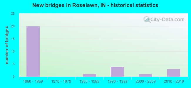
- New bridges - historical statistics
- 201960-1969
- 11980-1989
- 41990-1999
- 12000-2009
- 32010-2019

- Reconstructed bridges - Historical Statistics
- 31980-1989
- 11990-1999
- 22000-2009
- 62010-2019


- Bridge Condition - Deck
- 23.8%Very good
- 61.9%Good
- 14.3%Satisfactory

- Bridge Condition - Superstructure
- 28.6%Very good
- 42.9%Good
- 14.3%Satisfactory
- 14.3%Fair

- Bridge Condition - Substructure
- 14.3%Very good
- 66.7%Good
- 19.0%Satisfactory

- Bridge Condition - Channel
- 23.1%Very good
- 38.5%Good
- 38.5%Satisfactory
Find on map >> Show street view
Structure Number: 19801, Location: 06.28 N SR 14 (Lat: 41.104431, Lng: -87.333769), Route carried "on" structure: State highway 55, Year Built: 2013, Status: Open, Structure Length: 2.57m (8.43ft), Average Daily Traffic: 710 (year 2006), Truck Traffic: 14%, Average Future Daily Traffic: 890 (year 2032), Design Load: HL 93, Features Intersected: KNIGHT DITCH
Minimum Vertical Clearance: 30+ m (98+ ft), Kilometerpoint: 46.510, Lanes on structure: 2, Owner: State Highway Agency, Approaching Roadway Width: 11.6m (38.1ft), Skew: 3 degrees, Material/Design: Concrete continuous, Design/Construction: Slab, Number Of Spans In Main Unit: 3, Length of Maximum Span: 9.8m (32.2ft), Curb-To-Curb Width: 10.8m (35.4ft), Out-to-Out Width: 11.7m (38.4ft)
Condition: Deck: Good, Superstructure: Good, Substructure: Good, Channel: Very good, Operating Rating: 56.1 metric tons, Method Used To Determine Operating Rating: Load and Resistance Factor Rating (LRFR) rating reported by rating factor(RF) method using HL-93 loadings, Inventory Rating: 43.1 metric tons, Method Used To Determine Inventory Rating: Load and Resistance Factor Rating (LRFR) rating reported by rating factor(RF) method using HL-93 loadings, Structural Evaluation: Better than present minimum criteria, Deck Geometry: Equal to present minimum criteria, Waterway Adequacy: Superior to present desirable criteria, Approach Roadway Alignment: Equal to present desirable criteria, Designated Inspection Frequency: Every 24 months, Inspection Date: September 2021, Deck Structure Type: Concrete Cast-file-Place, Wearing Surface/Protective System: Wearing Surface: Monolithic Concrete, Deck Protection: Epoxy Coated Reinforcing
Find on map >> Show street view
Structure Number: 3816, Location: 03.99 N SR 14 (Lat: 41.071131, Lng: -87.270639), Route carried "on" structure: Alternate County highway , Year Built: 1966, Year Reconstructed: 1992, Status: Open, Structure Length: 6.07m (19.91ft), Average Daily Traffic: 110 (year 2004), Truck Traffic: 10%, Average Future Daily Traffic: 183 (year 2030), Design Load: HS 20, Features Intersected: I-65 NB/SB, Facility Carried by Structure: CR 400 N/FAIR OAKS
Minimum Vertical Clearance: 30+ m (98+ ft), Kilometerpoint: 0.000, Lanes on structure: 2, Lanes under structure: 4, Owner: State Highway Agency, Approaching Roadway Width: 7.9m (25.9ft), Material/Design: Steel continuous, Design/Construction: Stringer/Multi-beam, Number Of Spans In Main Unit: 2, Length of Maximum Span: 29.9m (98.1ft), Curb-To-Curb Width: 8.0m (26.2ft), Out-to-Out Width: 8.9m (29.2ft)
Condition: Deck: Good, Superstructure: Good, Substructure: Good, Operating Rating: 50.7 metric tons, Method Used To Determine Operating Rating: Load Factor (LF), Inventory Rating: 30.4 metric tons, Method Used To Determine Inventory Rating: Load Factor (LF), Structural Evaluation: Better than present minimum criteria, Deck Geometry: Somewhat better than minimum adequacy, Underclear: Somewhat better than minimum adequacy, Approach Roadway Alignment: Equal to present desirable criteria, Designated Inspection Frequency: Every 24 months, Other Special Inspection Frequency: Every 60 months, Inspection Date: May 2021, Other Special Inspection Date: August 2018, Deck Structure Type: Concrete Cast-file-Place, Wearing Surface/Protective System: Wearing Surface: Monolithic Concrete, Deck Protection: Epoxy Coated Reinforcing
Find on map >> Show street view
Structure Number: 3817, Location: 04.01 S SR 10 (Lat: 41.086381, Lng: -87.267631), Route carried "on" structure: Interstate 65, Year Built: 1966, Year Reconstructed: 1988, Status: Open, Structure Length: 4.24m (13.91ft), Average Daily Traffic: 13,885 (year 2004), Truck Traffic: 10%, Average Future Daily Traffic: 25,146 (year 2030), Design Load: HS 20, Features Intersected: KNIGHT ROAD/CR 500N
Minimum Vertical Clearance: 30+ m (98+ ft), Kilometerpoint: 362.086, Lanes on structure: 2, Lanes under structure: 2, Base Highway Network: Yes (, Subroute: 1), Owner: State Highway Agency, Approaching Roadway Width: 12.2m (40.0ft), Skew: 2 degrees, Material/Design: Steel continuous, Design/Construction: Stringer/Multi-beam, Number Of Spans In Main Unit: 3, Length of Maximum Span: 18.9m (62.0ft), Curb-To-Curb Width: 19.6m (64.3ft), Out-to-Out Width: 20.4m (66.9ft)
Condition: Deck: Good, Superstructure: Very good, Substructure: Good, Operating Rating: 48.9 metric tons, Method Used To Determine Operating Rating: Load and Resistance Factor (LRFR), Inventory Rating: 48.1 metric tons, Method Used To Determine Inventory Rating: Load and Resistance Factor (LRFR), Structural Evaluation: Better than present minimum criteria, Deck Geometry: Superior to present desirable criteria, Underclear: Meets minimum limits, Approach Roadway Alignment: Equal to present desirable criteria, Designated Inspection Frequency: Every 24 months, Inspection Date: May 2021, Deck Structure Type: Concrete Cast-file-Place, Wearing Surface/Protective System: Wearing Surface: Epoxy Overlay, Deck Protection: Epoxy Coated Reinforcing
Find on map >> Show street view
Structure Number: 3818, Location: 04.01 S SR 10 (Lat: 41.086361, Lng: -87.267961), Route carried "on" structure: Interstate 65, Year Built: 1966, Year Reconstructed: 1988, Status: Open, Structure Length: 4.24m (13.91ft), Average Daily Traffic: 13,885 (year 2004), Truck Traffic: 10%, Average Future Daily Traffic: 25,146 (year 2030), Design Load: HS 20, Features Intersected: KNIGHT ROAD/CR 500N
Minimum Vertical Clearance: 30+ m (98+ ft), Kilometerpoint: 362.086, Lanes on structure: 2, Lanes under structure: 2, Base Highway Network: Yes (, Subroute: 1), Owner: State Highway Agency, Approaching Roadway Width: 12.2m (40.0ft), Skew: 2 degrees, Material/Design: Steel continuous, Design/Construction: Stringer/Multi-beam, Number Of Spans In Main Unit: 3, Length of Maximum Span: 18.9m (62.0ft), Curb-To-Curb Width: 12.2m (40.0ft), Out-to-Out Width: 13.0m (42.7ft)
Condition: Deck: Very good, Superstructure: Very good, Substructure: Good, Operating Rating: 48.9 metric tons, Method Used To Determine Operating Rating: Load and Resistance Factor (LRFR), Inventory Rating: 48.1 metric tons, Method Used To Determine Inventory Rating: Load and Resistance Factor (LRFR), Structural Evaluation: Better than present minimum criteria, Deck Geometry: Better than present minimum criteria, Underclear: Meets minimum limits, Approach Roadway Alignment: Equal to present desirable criteria, Designated Inspection Frequency: Every 24 months, Inspection Date: May 2021, Deck Structure Type: Concrete Cast-file-Place, Wearing Surface/Protective System: Wearing Surface: Epoxy Overlay, Deck Protection: Epoxy Coated Reinforcing
Find on map >> Show street view
Structure Number: 3819, Location: 03.92 S SR 10 (Lat: 41.087681, Lng: -87.266869), Route carried "on" structure: Interstate 65, Year Built: 1966, Year Reconstructed: 2011, Status: Open, Structure Length: 5.21m (17.09ft), Average Daily Traffic: 13,885 (year 2004), Truck Traffic: 10%, Average Future Daily Traffic: 25,146 (year 2030), Design Load: HS 20+Mod, Features Intersected: CSX RR
Minimum Vertical Clearance: 30+ m (98+ ft), Kilometerpoint: 362.231, Lanes on structure: 2, Base Highway Network: Yes (, Subroute: 1), Owner: State Highway Agency, Approaching Roadway Width: 12.2m (40.0ft), Skew: 3 degrees, Material/Design: Steel continuous, Design/Construction: Stringer/Multi-beam, Number Of Spans In Main Unit: 3, Length of Maximum Span: 19.2m (63.0ft), Curb-To-Curb Width: 12.0m (39.4ft), Out-to-Out Width: 13.0m (42.7ft)
Condition: Deck: Good, Superstructure: Very good, Substructure: Good, Operating Rating: 59.0 metric tons, Method Used To Determine Operating Rating: Load and Resistance Factor Rating (LRFR) rating reported by rating factor(RF) method using HL-93 loadings, Inventory Rating: 45.7 metric tons, Method Used To Determine Inventory Rating: Load and Resistance Factor Rating (LRFR) rating reported by rating factor(RF) method using HL-93 loadings, Structural Evaluation: Better than present minimum criteria, Deck Geometry: Equal to present minimum criteria, Underclear: Equal to present desirable criteria, Approach Roadway Alignment: Equal to present desirable criteria, Designated Inspection Frequency: Every 24 months, Inspection Date: May 2021, Deck Structure Type: Concrete Cast-file-Place, Wearing Surface/Protective System: Wearing Surface: Latex Concrete, Deck Protection: Epoxy Coated Reinforcing
Find on map >> Show street view
Structure Number: 382, Location: 03.92 S SR 10 (Lat: 41.087919, Lng: -87.267089), Route carried "on" structure: Interstate 65, Year Built: 1966, Year Reconstructed: 2012, Status: Open, Structure Length: 5.20m (17.06ft), Average Daily Traffic: 13,885 (year 2004), Truck Traffic: 10%, Average Future Daily Traffic: 25,146 (year 2030), Design Load: HS 20+Mod, Features Intersected: CSX RR
Minimum Vertical Clearance: 30+ m (98+ ft), Kilometerpoint: 362.231, Lanes on structure: 2, Base Highway Network: Yes (, Subroute: 1), Owner: State Highway Agency, Approaching Roadway Width: 12.2m (40.0ft), Skew: 3 degrees, Material/Design: Steel continuous, Design/Construction: Stringer/Multi-beam, Number Of Spans In Main Unit: 3, Length of Maximum Span: 19.2m (63.0ft), Curb-To-Curb Width: 19.6m (64.3ft), Out-to-Out Width: 20.5m (67.3ft)
Condition: Deck: Good, Superstructure: Very good, Substructure: Good, Operating Rating: 45.0 metric tons, Method Used To Determine Operating Rating: Load and Resistance Factor Rating (LRFR) rating reported by rating factor(RF) method using HL-93 loadings, Inventory Rating: 34.7 metric tons, Method Used To Determine Inventory Rating: Load and Resistance Factor Rating (LRFR) rating reported by rating factor(RF) method using HL-93 loadings, Structural Evaluation: Better than present minimum criteria, Deck Geometry: Superior to present desirable criteria, Underclear: Equal to present desirable criteria, Approach Roadway Alignment: Equal to present desirable criteria, Designated Inspection Frequency: Every 24 months, Inspection Date: May 2021, Deck Structure Type: Concrete Cast-file-Place, Wearing Surface/Protective System: Wearing Surface: Monolithic Concrete, Deck Protection: Epoxy Coated Reinforcing
Find on map >> Show street view
Structure Number: 3821, Location: 02.77 S SR 10 (Lat: 41.104069, Lng: -87.265275), Route carried "on" structure: Interstate 65, Year Built: 1966, Year Reconstructed: 2018, Status: Open, Structure Length: 2.90m (9.51ft), Average Daily Traffic: 33,690 (year 2013), Truck Traffic: 53%, Average Future Daily Traffic: 45,400 (year 2035), Design Load: HS 20+Mod, Features Intersected: STOVER MAIN DITCH
Minimum Vertical Clearance: 30+ m (98+ ft), Kilometerpoint: 364.082, Lanes on structure: 2, Base Highway Network: Yes (, Subroute: 1), Owner: State Highway Agency, Approaching Roadway Width: 12.9m (42.3ft), Material/Design: Concrete continuous, Design/Construction: Slab, Number Of Spans In Main Unit: 3, Length of Maximum Span: 11.4m (37.4ft), Curb-To-Curb Width: 12.1m (39.7ft), Out-to-Out Width: 13.0m (42.7ft)
Condition: Deck: Very good, Superstructure: Good, Substructure: Good, Channel: Satisfactory, Operating Rating: 42.4 metric tons, Method Used To Determine Operating Rating: Load and Resistance Factor Rating (LRFR) rating reported by rating factor(RF) method using HL-93 loadings, Inventory Rating: 32.7 metric tons, Method Used To Determine Inventory Rating: Load and Resistance Factor Rating (LRFR) rating reported by rating factor(RF) method using HL-93 loadings, Structural Evaluation: Better than present minimum criteria, Deck Geometry: Equal to present minimum criteria, Waterway Adequacy: Equal to present desirable criteria, Approach Roadway Alignment: Equal to present desirable criteria, Designated Inspection Frequency: Every 24 months, Inspection Date: May 2021, Deck Structure Type: Concrete Cast-file-Place, Wearing Surface/Protective System: Wearing Surface: Latex Concrete
Find on map >> Show street view
Structure Number: 3822, Location: 02.77 S SR 10 (Lat: 41.104089, Lng: -87.265581), Route carried "on" structure: Interstate 65, Year Built: 1966, Year Reconstructed: 2018, Status: Open, Structure Length: 2.90m (9.51ft), Average Daily Traffic: 33,690 (year 2013), Truck Traffic: 53%, Average Future Daily Traffic: 45,400 (year 2035), Design Load: HS 20+Mod, Features Intersected: STOVER MAIN DITCH
Minimum Vertical Clearance: 30+ m (98+ ft), Kilometerpoint: 364.082, Lanes on structure: 2, Base Highway Network: Yes (, Subroute: 1), Owner: State Highway Agency, Approaching Roadway Width: 12.9m (42.3ft), Material/Design: Concrete continuous, Design/Construction: Slab, Number Of Spans In Main Unit: 3, Length of Maximum Span: 11.4m (37.4ft), Curb-To-Curb Width: 12.1m (39.7ft), Out-to-Out Width: 13.0m (42.7ft)
Condition: Deck: Good, Superstructure: Good, Substructure: Good, Channel: Satisfactory, Operating Rating: 42.4 metric tons, Method Used To Determine Operating Rating: Load and Resistance Factor Rating (LRFR) rating reported by rating factor(RF) method using HL-93 loadings, Inventory Rating: 32.7 metric tons, Method Used To Determine Inventory Rating: Load and Resistance Factor Rating (LRFR) rating reported by rating factor(RF) method using HL-93 loadings, Structural Evaluation: Better than present minimum criteria, Deck Geometry: Equal to present minimum criteria, Waterway Adequacy: Better than present minimum criteria, Approach Roadway Alignment: Equal to present desirable criteria, Designated Inspection Frequency: Every 24 months, Inspection Date: May 2021, Deck Structure Type: Concrete Cast-file-Place, Wearing Surface/Protective System: Wearing Surface: Latex Concrete, Deck Protection: Epoxy Coated Reinforcing
Find on map >> Show street view
Structure Number: 3823, Location: 02.15 N SR 10 (Lat: 41.174181, Lng: -87.277361), Route carried "on" structure: County highway , Year Built: 1966, Year Reconstructed: 2004, Status: Open, Structure Length: 8.84m (29.00ft), Average Daily Traffic: 1,807 (year 2004), Truck Traffic: 10%, Average Future Daily Traffic: 3,001 (year 2030), Design Load: HS 20, Features Intersected: I-65 NB/SB, Facility Carried by Structure: THAYER ROAD
Minimum Vertical Clearance: 30+ m (98+ ft), Kilometerpoint: 0.000, Lanes on structure: 2, Lanes under structure: 4, Owner: State Highway Agency, Approaching Roadway Width: 9.6m (31.5ft), Skew: 9 degrees, Material/Design: Steel continuous, Design/Construction: Stringer/Multi-beam, Number Of Spans In Main Unit: 5, Length of Maximum Span: 23.7m (77.8ft), Curb-To-Curb Width: 9.6m (31.5ft), Out-to-Out Width: 10.5m (34.4ft)
Condition: Deck: Very good, Superstructure: Good, Substructure: Good, Operating Rating: 60.6 metric tons, Method Used To Determine Operating Rating: Load and Resistance Factor Rating (LRFR) rating reported by rating factor(RF) method using HL-93 loadings, Inventory Rating: 46.7 metric tons, Method Used To Determine Inventory Rating: Load and Resistance Factor Rating (LRFR) rating reported by rating factor(RF) method using HL-93 loadings, Structural Evaluation: Better than present minimum criteria, Deck Geometry: Somewhat better than minimum adequacy, Underclear: Meets minimum limits, Approach Roadway Alignment: Equal to present desirable criteria, Designated Inspection Frequency: Every 24 months, Inspection Date: May 2021, Deck Structure Type: Concrete Cast-file-Place, Wearing Surface/Protective System: Wearing Surface: Epoxy Overlay, Deck Protection: Epoxy Coated Reinforcing
Find on map >> Show street view
Structure Number: 3824, Location: 03.67 N SR 10 (Lat: 41.195500, Lng: -87.284769), Route carried "on" structure: Interstate 65, Year Built: 1966, Year Reconstructed: 2015, Status: Open, Structure Length: 4.51m (14.80ft), Average Daily Traffic: 14,069 (year 2015), Truck Traffic: 10%, Average Future Daily Traffic: 25,479 (year 2030), Design Load: HS 20+Mod, Features Intersected: NORFOLK SOUTHERN RR
Minimum Vertical Clearance: 30+ m (98+ ft), Kilometerpoint: 374.446, Lanes on structure: 3, Base Highway Network: Yes (, Subroute: 1), Owner: State Highway Agency, Approaching Roadway Width: 18.4m (60.4ft), Material/Design: Steel continuous, Design/Construction: Stringer/Multi-beam, Number Of Spans In Main Unit: 3, Length of Maximum Span: 16.6m (54.5ft), Curb-To-Curb Width: 18.4m (60.4ft), Out-to-Out Width: 19.3m (63.3ft)
Condition: Deck: Good, Superstructure: Fair, Substructure: Satisfactory, Operating Rating: 82.9 metric tons, Method Used To Determine Operating Rating: Load Factor (LF), Inventory Rating: 46.7 metric tons, Method Used To Determine Inventory Rating: Load Factor (LF), Structural Evaluation: Somewhat better than minimum adequacy, Deck Geometry: Equal to present desirable criteria, Underclear: Better than present minimum criteria, Approach Roadway Alignment: Equal to present desirable criteria, Length Of Structure Improvement: 4.51m (14.80ft), Designated Inspection Frequency: Every 24 months, Inspection Date: May 2021, Bridge Improvement Cost: $625,000, Total Project Cost: $625,000, Deck Structure Type: Concrete Cast-file-Place, Wearing Surface/Protective System: Wearing Surface: Latex Concrete
Find on map >> Show street view
Structure Number: 3825, Location: 03.67 N SR 10 (Lat: 41.195519, Lng: -87.285111), Route carried "on" structure: Interstate 65, Year Built: 1966, Year Reconstructed: 2015, Status: Open, Structure Length: 4.51m (14.80ft), Average Daily Traffic: 14,069 (year 2004), Truck Traffic: 10%, Average Future Daily Traffic: 25,479 (year 2030), Design Load: HS 20+Mod, Features Intersected: CONRAIL RR
Minimum Vertical Clearance: 30+ m (98+ ft), Kilometerpoint: 374.446, Lanes on structure: 2, Base Highway Network: Yes (, Subroute: 1), Owner: State Highway Agency, Approaching Roadway Width: 18.4m (60.4ft), Material/Design: Steel continuous, Design/Construction: Stringer/Multi-beam, Number Of Spans In Main Unit: 3, Length of Maximum Span: 16.6m (54.5ft), Curb-To-Curb Width: 18.4m (60.4ft), Out-to-Out Width: 20.2m (66.3ft)
Condition: Deck: Good, Superstructure: Satisfactory, Substructure: Satisfactory, Operating Rating: 81.5 metric tons, Method Used To Determine Operating Rating: Load Factor (LF), Inventory Rating: 46.7 metric tons, Method Used To Determine Inventory Rating: Load Factor (LF), Structural Evaluation: Equal to present minimum criteria, Deck Geometry: Superior to present desirable criteria, Underclear: Better than present minimum criteria, Approach Roadway Alignment: Equal to present desirable criteria, Length Of Structure Improvement: 4.51m (14.80ft), Designated Inspection Frequency: Every 24 months, Inspection Date: May 2021, Bridge Improvement Cost: $625,000, Total Project Cost: $625,000, Deck Structure Type: Concrete Cast-file-Place, Wearing Surface/Protective System: Wearing Surface: Latex Concrete
Find on map >> Show street view
Structure Number: 3826, Location: 03.89 N SR 10 (Lat: 41.198781, Lng: -87.284775), Route carried "on" structure: Interstate 65, Year Built: 1966, Year Reconstructed: 2015, Status: Open, Structure Length: 3.44m (11.29ft), Average Daily Traffic: 14,069 (year 2004), Truck Traffic: 10%, Average Future Daily Traffic: 25,479 (year 2030), Design Load: HS 20+Mod, Features Intersected: DEHAAN DITCH
Minimum Vertical Clearance: 30+ m (98+ ft), Kilometerpoint: 374.800, Lanes on structure: 2, Base Highway Network: Yes (, Subroute: 1), Owner: State Highway Agency, Approaching Roadway Width: 17.8m (58.4ft), Skew: 1 degrees, Material/Design: Concrete continuous, Design/Construction: Stringer/Multi-beam, Number Of Spans In Main Unit: 3, Length of Maximum Span: 13.6m (44.6ft), Curb-To-Curb Width: 17.8m (58.4ft), Out-to-Out Width: 18.7m (61.4ft)
Condition: Deck: Good, Superstructure: Fair, Substructure: Satisfactory, Channel: Good, Operating Rating: 43.1 metric tons, Method Used To Determine Operating Rating: Load and Resistance Factor Rating (LRFR) rating reported by rating factor(RF) method using HL-93 loadings, Inventory Rating: 31.8 metric tons, Method Used To Determine Inventory Rating: Load and Resistance Factor Rating (LRFR) rating reported by rating factor(RF) method using HL-93 loadings, Structural Evaluation: Somewhat better than minimum adequacy, Deck Geometry: Superior to present desirable criteria, Waterway Adequacy: Better than present minimum criteria, Approach Roadway Alignment: Equal to present desirable criteria, Designated Inspection Frequency: Every 24 months, Inspection Date: May 2021, Deck Structure Type: Concrete Cast-file-Place, Wearing Surface/Protective System: Wearing Surface: Latex Concrete
Find on map >> Show street view
Structure Number: 3827, Location: 03.89 N SR 10 (Lat: 41.198681, Lng: -87.285081), Route carried "on" structure: Interstate 65, Year Built: 1966, Year Reconstructed: 2015, Status: Open, Structure Length: 3.44m (11.29ft), Average Daily Traffic: 14,069 (year 2004), Truck Traffic: 10%, Average Future Daily Traffic: 25,479 (year 2030), Design Load: HS 20+Mod, Features Intersected: DEHAAN DITCH
Minimum Vertical Clearance: 30+ m (98+ ft), Kilometerpoint: 374.800, Lanes on structure: 2, Base Highway Network: Yes (, Subroute: 1), Owner: State Highway Agency, Approaching Roadway Width: 17.8m (58.4ft), Skew: 1 degrees, Material/Design: Concrete continuous, Design/Construction: Stringer/Multi-beam, Number Of Spans In Main Unit: 3, Length of Maximum Span: 13.6m (44.6ft), Curb-To-Curb Width: 17.8m (58.4ft), Out-to-Out Width: 18.7m (61.4ft)
Condition: Deck: Good, Superstructure: Fair, Substructure: Good, Channel: Very good, Operating Rating: 43.1 metric tons, Method Used To Determine Operating Rating: Load and Resistance Factor Rating (LRFR) rating reported by rating factor(RF) method using HL-93 loadings, Inventory Rating: 33.0 metric tons, Method Used To Determine Inventory Rating: Load and Resistance Factor Rating (LRFR) rating reported by rating factor(RF) method using HL-93 loadings, Structural Evaluation: Somewhat better than minimum adequacy, Deck Geometry: Superior to present desirable criteria, Waterway Adequacy: Superior to present desirable criteria, Approach Roadway Alignment: Equal to present desirable criteria, Designated Inspection Frequency: Every 24 months, Inspection Date: May 2021, Deck Structure Type: Concrete Cast-file-Place, Wearing Surface/Protective System: Wearing Surface: Latex Concrete
Find on map >> Show street view
Structure Number: 38291, Location: 04.82 N SR 10 (Lat: 41.211419, Lng: -87.291061), Route carried "on" structure: Interstate 65, Year Built: 2018, Status: Open, Structure Length: 6.26m (20.54ft), Average Daily Traffic: 18,482 (year 2015), Truck Traffic: 49%, Average Future Daily Traffic: 25,370 (year 2035), Design Load: HL 93, Features Intersected: KANKAKEE RIVER
Minimum Vertical Clearance: 30+ m (98+ ft), Kilometerpoint: 376.297, Lanes on structure: 2, Base Highway Network: Yes (, Subroute: 1), Owner: State Highway Agency, Approaching Roadway Width: 17.7m (58.1ft), Skew: 1 degrees, Material/Design: Steel, Design/Construction: Stringer/Multi-beam, Number Of Spans In Main Unit: 1, Length of Maximum Span: 62.2m (204.1ft), Curb-To-Curb Width: 17.6m (57.7ft), Out-to-Out Width: 18.5m (60.7ft)
Condition: Deck: Very good, Superstructure: Very good, Substructure: Very good, Channel: Very good, Operating Rating: 63.5 metric tons, Method Used To Determine Operating Rating: Load and Resistance Factor Rating (LRFR) rating reported by rating factor(RF) method using HL-93 loadings, Inventory Rating: 48.9 metric tons, Method Used To Determine Inventory Rating: Load and Resistance Factor Rating (LRFR) rating reported by rating factor(RF) method using HL-93 loadings, Structural Evaluation: Equal to present desirable criteria, Deck Geometry: Superior to present desirable criteria, Waterway Adequacy: Superior to present desirable criteria, Approach Roadway Alignment: Equal to present desirable criteria, Designated Inspection Frequency: Every 24 months, Inspection Date: May 2021, Deck Structure Type: Concrete Cast-file-Place, Wearing Surface/Protective System: Wearing Surface: Monolithic Concrete, Deck Protection: Epoxy Coated Reinforcing
Find on map >> Show street view
Structure Number: 3700117, Location: 00.25 N OF CR 1300 N (Lat: 41.208961, Lng: -87.256431), Route carried "on" structure: County highway 11, Year Built: 2002, Status: Open, Structure Length: 2.17m (7.12ft), Average Daily Traffic: 202 (year 2012), Truck Traffic: 5%, Average Future Daily Traffic: 288 (year 2032), Design Load: HS 20, Features Intersected: TAYLOR DITCH
Minimum Vertical Clearance: 30+ m (98+ ft), Kilometerpoint: 0.000, Lanes on structure: 2, Owner: County Highway Agency, Approaching Roadway Width: 4.6m (15.1ft), Skew: 3 degrees, Material/Design: Concrete continuous, Design/Construction: Slab, Number Of Spans In Main Unit: 3, Length of Maximum Span: 8.2m (26.9ft), Curb-To-Curb Width: 8.6m (28.2ft), Out-to-Out Width: 8.7m (28.5ft)
Condition: Deck: Good, Superstructure: Good, Substructure: Very good, Channel: Good, Operating Rating: 62.0 metric tons, Method Used To Determine Operating Rating: Load Factor (LF), Inventory Rating: 37.2 metric tons, Method Used To Determine Inventory Rating: Load Factor (LF), Structural Evaluation: Better than present minimum criteria, Deck Geometry: Equal to present minimum criteria, Waterway Adequacy: Equal to present minimum criteria, Approach Roadway Alignment: Equal to present desirable criteria, Designated Inspection Frequency: Every 24 months, Inspection Date: August 2020, Deck Structure Type: Concrete Cast-file-Place, Wearing Surface/Protective System: Wearing Surface: Monolithic Concrete, Membrane: Epoxy, Deck Protection: Epoxy Coated Reinforcing
Find on map >> Show street view
Structure Number: 3700118, Location: 00.00 N OF CR 1300 N (Lat: 41.203219, Lng: -87.256369), Route carried "on" structure: County highway 11, Year Built: 1987, Status: Open, Structure Length: 2.19m (7.19ft), Average Daily Traffic: 210 (year 2012), Truck Traffic: 5%, Average Future Daily Traffic: 300 (year 2032), Features Intersected: DEHAAN DITCH
Minimum Vertical Clearance: 30+ m (98+ ft), Kilometerpoint: 0.000, Lanes on structure: 2, Owner: County Highway Agency, Approaching Roadway Width: 5.8m (19.0ft), Skew: 3 degrees, Material/Design: Prestressed concrete, Design/Construction: Box Beam or Girders - Multiple, Number Of Spans In Main Unit: 1, Length of Maximum Span: 20.6m (67.6ft), Curb-To-Curb Width: 7.3m (24.0ft), Out-to-Out Width: 8.1m (26.6ft)
Condition: Deck: Satisfactory, Superstructure: Good, Substructure: Good, Channel: Good, Operating Rating: 77.1 metric tons, Method Used To Determine Operating Rating: Load Factor (LF), Inventory Rating: 27.7 metric tons, Method Used To Determine Inventory Rating: Load Factor (LF), Structural Evaluation: Equal to present minimum criteria, Deck Geometry: Somewhat better than minimum adequacy, Waterway Adequacy: Equal to present minimum criteria, Approach Roadway Alignment: Equal to present desirable criteria, Designated Inspection Frequency: Every 24 months, Inspection Date: August 2020, Deck Structure Type: Concrete Cast-file-Place, Wearing Surface/Protective System: Wearing Surface: Monolithic Concrete
Find on map >> Show street view
Structure Number: 4500228, Location: 00.20 S of 217th AVE (Lat: 41.218639, Lng: -87.275900), Route carried "on" structure: County highway , Year Built: 2015, Status: Open, Structure Length: 6.18m (20.28ft), Average Daily Traffic: 948 (year 2019), Truck Traffic: 24%, Average Future Daily Traffic: 1,169 (year 2040), Design Load: HL 93, Features Intersected: KANKAKEE RIVER, Facility Carried by Structure: CLAY ST
Minimum Vertical Clearance: 30+ m (98+ ft), Kilometerpoint: 0.000, Lanes on structure: 2, Owner: County Highway Agency, Approaching Roadway Width: 8.5m (27.9ft), Skew: 1 degrees, Navigation Control: Yes ( Vertical Clearance: 8.7m (28.5ft), Horizontal Clearance: 23.8m (78.1ft)), Material/Design: Prestressed concrete continuous, Design/Construction: Tee Beam, Number Of Spans In Main Unit: 3, Length of Maximum Span: 23.8m (78.1ft), Curb-To-Curb Width: 8.9m (29.2ft), Out-to-Out Width: 9.1m (29.9ft)
Condition: Deck: Very good, Superstructure: Very good, Substructure: Very good, Channel: Good, Operating Rating: 70.6 metric tons, Method Used To Determine Operating Rating: Load and Resistance Factor (LRFR), Inventory Rating: 47.1 metric tons, Method Used To Determine Inventory Rating: Load and Resistance Factor (LRFR), Structural Evaluation: Equal to present desirable criteria, Deck Geometry: Somewhat better than minimum adequacy, Waterway Adequacy: Equal to present desirable criteria, Approach Roadway Alignment: Equal to present desirable criteria, Designated Inspection Frequency: Every 24 months, Inspection Date: August 2020, Deck Structure Type: Concrete Cast-file-Place, Wearing Surface/Protective System: Wearing Surface: Monolithic Concrete, Deck Protection: Epoxy Coated Reinforcing
Find on map >> Show street view
Structure Number: 5600033, Location: 0.3 MI S CR 800 N (Lat: 41.110581, Lng: -87.352861), Route carried "on" structure: County highway 51, Year Built: 1991, Status: Open, Structure Length: 1.66m (5.45ft), Average Daily Traffic: 143 (year 2018), Truck Traffic: 5%, Average Future Daily Traffic: 190 (year 2038), Features Intersected: MOFFITT DITCH, Facility Carried by Structure: CR 200 E
Minimum Vertical Clearance: 30+ m (98+ ft), Kilometerpoint: 0.000, Lanes on structure: 2, Owner: County Highway Agency, Approaching Roadway Width: 5.5m (18.0ft), Material/Design: Prestressed concrete, Design/Construction: Box Beam or Girders - Multiple, Number Of Spans In Main Unit: 1, Length of Maximum Span: 15.4m (50.5ft), Curb-To-Curb Width: 7.2m (23.6ft), Out-to-Out Width: 7.4m (24.3ft)
Condition: Deck: Good, Superstructure: Good, Substructure: Good, Channel: Good, Operating Rating: 46.7 metric tons, Method Used To Determine Operating Rating: Field evaluation and documented engineering judgment, Inventory Rating: 27.8 metric tons, Method Used To Determine Inventory Rating: Field evaluation and documented engineering judgment, Structural Evaluation: Equal to present minimum criteria, Deck Geometry: Meets minimum limits, Waterway Adequacy: Better than present minimum criteria, Approach Roadway Alignment: Equal to present desirable criteria, Length Of Structure Improvement: 1.66m (5.45ft), Designated Inspection Frequency: Every 24 months, Inspection Date: September 2020, Bridge Improvement Cost: $80,000, Roadway Improvement Cost: $90,000, Total Project Cost: $170,000 ( Estimate for 2018), Deck Structure Type: Concrete Precast Panels
Find on map >> Show street view
Structure Number: 5600034, Location: 0.1 MI S CR 800 N (Lat: 41.115361, Lng: -87.352961), Route carried "on" structure: County highway 51, Year Built: 1991, Status: Open, Structure Length: 1.22m (4.00ft), Average Daily Traffic: 143 (year 2018), Truck Traffic: 5%, Average Future Daily Traffic: 190 (year 2038), Features Intersected: KNIGHT DITCH, Facility Carried by Structure: CR 200 E
Minimum Vertical Clearance: 30+ m (98+ ft), Kilometerpoint: 0.000, Lanes on structure: 2, Owner: County Highway Agency, Approaching Roadway Width: 5.5m (18.0ft), Skew: 3 degrees, Material/Design: Prestressed concrete, Design/Construction: Box Beam or Girders - Multiple, Number Of Spans In Main Unit: 1, Length of Maximum Span: 11.6m (38.1ft), Curb-To-Curb Width: 7.2m (23.6ft), Out-to-Out Width: 7.3m (24.0ft)
Condition: Deck: Satisfactory, Superstructure: Satisfactory, Substructure: Good, Channel: Satisfactory, Operating Rating: 54.5 metric tons, Method Used To Determine Operating Rating: Field evaluation and documented engineering judgment, Inventory Rating: 32.7 metric tons, Method Used To Determine Inventory Rating: Field evaluation and documented engineering judgment, Structural Evaluation: Equal to present minimum criteria, Deck Geometry: Meets minimum limits, Waterway Adequacy: Somewhat better than minimum adequacy, Approach Roadway Alignment: Equal to present desirable criteria, Designated Inspection Frequency: Every 24 months, Inspection Date: September 2020, Deck Structure Type: Concrete Precast Panels, Wearing Surface/Protective System: Wearing Surface: Bituminous
Find on map >> Show street view
Structure Number: 5600036, Location: 0.8 MI N CR 1300 N (Lat: 41.199450, Lng: -87.275769), Route carried "on" structure: County highway 347, Year Built: 1991, Status: Open, Structure Length: 2.68m (8.79ft), Average Daily Traffic: 143 (year 2018), Truck Traffic: 5%, Average Future Daily Traffic: 190 (year 2038), Design Load: HS 20, Features Intersected: DEHAAN DITCH, Facility Carried by Structure: CR 600 E
Minimum Vertical Clearance: 30+ m (98+ ft), Kilometerpoint: 0.000, Lanes on structure: 2, Owner: County Highway Agency, Approaching Roadway Width: 6.7m (22.0ft), Material/Design: Concrete continuous, Design/Construction: Slab, Number Of Spans In Main Unit: 3, Length of Maximum Span: 10.2m (33.5ft), Curb-To-Curb Width: 7.9m (25.9ft), Out-to-Out Width: 7.9m (25.9ft)
Condition: Deck: Good, Superstructure: Good, Substructure: Satisfactory, Channel: Satisfactory, Operating Rating: 58.4 metric tons, Method Used To Determine Operating Rating: Load Factor (LF), Inventory Rating: 34.9 metric tons, Method Used To Determine Inventory Rating: Load Factor (LF), Structural Evaluation: Equal to present minimum criteria, Deck Geometry: Somewhat better than minimum adequacy, Waterway Adequacy: Somewhat better than minimum adequacy, Approach Roadway Alignment: Equal to present desirable criteria, Designated Inspection Frequency: Every 24 months, Inspection Date: September 2020, Deck Structure Type: Concrete Cast-file-Place, Wearing Surface/Protective System: Wearing Surface: Bituminous, Membrane: Preformed Fabric
Find on map >> Show street view
Structure Number: 5600136, Location: 0.0 MI INT CR 500 E (Lat: 41.188000, Lng: -87.294961), Route carried "on" structure: County highway 156, Year Built: 1993, Status: Open, Structure Length: 1.04m (3.41ft), Average Daily Traffic: 143 (year 2018), Truck Traffic: 5%, Average Future Daily Traffic: 190 (year 2038), Features Intersected: DEFRIES DITCH, Facility Carried by Structure: CR 1300 N
Minimum Vertical Clearance: 30+ m (98+ ft), Kilometerpoint: 0.000, Lanes on structure: 2, Owner: County Highway Agency, Approaching Roadway Width: 5.8m (19.0ft), Material/Design: Prestressed concrete, Design/Construction: Box Beam or Girders - Multiple, Number Of Spans In Main Unit: 1, Length of Maximum Span: 9.1m (29.9ft), Curb-To-Curb Width: 7.2m (23.6ft), Out-to-Out Width: 7.3m (24.0ft)
Condition: Deck: Satisfactory, Superstructure: Satisfactory, Substructure: Good, Channel: Satisfactory, Operating Rating: 47.7 metric tons, Method Used To Determine Operating Rating: Field evaluation and documented engineering judgment, Inventory Rating: 28.4 metric tons, Method Used To Determine Inventory Rating: Field evaluation and documented engineering judgment, Structural Evaluation: Equal to present minimum criteria, Deck Geometry: Meets minimum limits, Waterway Adequacy: Equal to present minimum criteria, Approach Roadway Alignment: Equal to present desirable criteria, Length Of Structure Improvement: 1.04m (3.41ft), Designated Inspection Frequency: Every 24 months, Inspection Date: September 2020, Bridge Improvement Cost: $50,000, Roadway Improvement Cost: $90,000, Total Project Cost: $140,000 ( Estimate for 2018), Deck Structure Type: Concrete Precast Panels
Find on map >> Show street view
Structure Number: 291, Location: 03.48 W SR 110 (Lat: 41.144469, Lng: -87.265808), Route carried "under" structure: Interstate 65, Year Built: 1966, Structure Length: 0. m, Average Daily Traffic: 14,070 (year 2004), Truck Traffic: 15%, Features Intersected: I-65 SB, Facility Carried by Structure: SR 10
Minimum Vertical Clearance: 4.90m (16.08ft), Kilometerpoint: 368.540, Lanes on structure: 2, Lanes under structure: 2, Material/Design: Steel continuous, Design/Construction: Stringer/Multi-beam, Length of Maximum Span: 20.1m (65.9ft)
Find on map >> Show street view
Structure Number: 291, Location: 03.48 W SR 110 (Lat: 41.144469, Lng: -87.265808), Route carried "under" structure: Interstate 65, Year Built: 1966, Structure Length: 0. m, Average Daily Traffic: 14,070 (year 2004), Truck Traffic: 15%, Features Intersected: I-65 NB, Facility Carried by Structure: SR 10
Minimum Vertical Clearance: 4.90m (16.08ft), Kilometerpoint: 368.540, Lanes on structure: 2, Lanes under structure: 2, Material/Design: Steel continuous, Design/Construction: Stringer/Multi-beam, Length of Maximum Span: 20.1m (65.9ft)
Find on map >> Show street view
Structure Number: 3816, Location: 03.99 N SR-14 (Lat: 41.071131, Lng: -87.270644), Route carried "under" structure: Interstate 65, Year Built: 1966, Structure Length: 0. m, Average Daily Traffic: 13,890 (year 2004), Truck Traffic: 20%, Features Intersected: I-65 NBL, Facility Carried by Structure: CR 400N/FAIR OAKS
Minimum Vertical Clearance: 5.08m (16.67ft), Kilometerpoint: 360.380, Lanes on structure: 2, Lanes under structure: 4, Material/Design: Steel continuous, Design/Construction: Stringer/Multi-beam, Length of Maximum Span: 29.9m (98.1ft)
Find on map >> Show street view
Structure Number: 3816, Location: 03.99 N SR-14 (Lat: 41.071131, Lng: -87.270644), Route carried "under" structure: Interstate 65, Year Built: 1966, Structure Length: 0. m, Average Daily Traffic: 13,389 (year 2004), Truck Traffic: 20%, Features Intersected: I-65 SBL, Facility Carried by Structure: CR 400N/FAIR OAKS
Minimum Vertical Clearance: 5.08m (16.67ft), Kilometerpoint: 360.380, Lanes on structure: 2, Lanes under structure: 4, Material/Design: Steel continuous, Design/Construction: Stringer/Multi-beam, Length of Maximum Span: 29.9m (98.1ft)
Find on map >> Show street view
Structure Number: 3817, Location: 04.01 S SR-10 (Lat: 41.086381, Lng: -87.267633), Route carried "under" structure: County highway , Year Built: 1966, Structure Length: 0. m, Average Daily Traffic: 132 (year 2004), Truck Traffic: 5%, Features Intersected: KNIGHT ROAD / CR 500 N, Facility Carried by Structure: I-65 NB
Minimum Vertical Clearance: 4.78m (15.68ft), Kilometerpoint: 0.000, Lanes on structure: 2, Lanes under structure: 2, Material/Design: Steel continuous, Design/Construction: Stringer/Multi-beam, Length of Maximum Span: 18.9m (62.0ft)
Find on map >> Show street view
Structure Number: 3818, Location: 04.01 S SR-10 (Lat: 41.086361, Lng: -87.267967), Route carried "under" structure: County highway , Year Built: 1966, Structure Length: 0. m, Average Daily Traffic: 132 (year 2004), Truck Traffic: 5%, Features Intersected: KNIGHT ROAD / CR 500 N, Facility Carried by Structure: I-65 SB
Minimum Vertical Clearance: 4.37m (14.34ft), Kilometerpoint: 0.000, Lanes on structure: 2, Lanes under structure: 2, Material/Design: Steel continuous, Design/Construction: Stringer/Multi-beam, Length of Maximum Span: 18.9m (62.0ft)
Find on map >> Show street view
Structure Number: 3823, Location: 02.15 N SR-10 (Lat: 41.174181, Lng: -87.277367), Route carried "under" structure: Interstate 65, Year Built: 1966, Structure Length: 0. m, Average Daily Traffic: 14,070 (year 2004), Truck Traffic: 15%, Features Intersected: I65 NBL, Facility Carried by Structure: THAYER ROAD
Minimum Vertical Clearance: 4.95m (16.24ft), Kilometerpoint: 372.000, Lanes on structure: 2, Lanes under structure: 4, Material/Design: Steel continuous, Design/Construction: Stringer/Multi-beam, Length of Maximum Span: 23.7m (77.8ft)
Find on map >> Show street view
Structure Number: 3823, Location: 02.15 N SR-10 (Lat: 41.174181, Lng: -87.277367), Route carried "under" structure: Interstate 65, Year Built: 1966, Structure Length: 0. m, Average Daily Traffic: 14,070 (year 2004), Truck Traffic: 15%, Features Intersected: I65 SBL, Facility Carried by Structure: THAYER ROAD
Minimum Vertical Clearance: 4.90m (16.08ft), Kilometerpoint: 372.000, Lanes on structure: 2, Lanes under structure: 4, Material/Design: Steel continuous, Design/Construction: Stringer/Multi-beam, Length of Maximum Span: 23.7m (77.8ft)