Bridge Statistics for Roscommon, Michigan (MI)
Condition, Traffic, Stress, Structural Evaluation, Project Costs
- National Bridge Inventory (NBI) Statistics
- 11Number of bridges
- 157ft / 47.8mTotal length
- $24,000Total costs
- 58,135Total average daily traffic
- 6,019Total average daily truck traffic
- National Bridge Inventory (NBI) Registered Bridges for Roscommon
- No street view available for this location
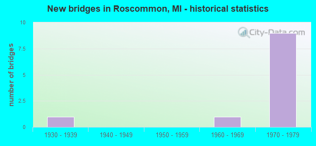
- New bridges - historical statistics
- 11930-1939
- 11960-1969
- 91970-1979


- Bridge Condition - Deck
- 28.6%Good
- 42.9%Satisfactory
- 28.6%Fair

- Bridge Condition - Superstructure
- 71.4%Good
- 14.3%Satisfactory
- 14.3%Fair

- Bridge Condition - Substructure
- 28.6%Good
- 57.1%Satisfactory
- 14.3%Fair

- Bridge Condition - Channel
- 66.7%Very good
- 33.3%Good
Find on map >> Show street view
Structure Number: 2068, Location: 18.0 MI SE OF GRAYLING (Lat: 44.540733, Lng: -84.550586), Route carried "on" structure: County highway 2065, Year Built: 1968, Status: Open, Structure Length: 1.86m (6.10ft), Average Daily Traffic: 286 (year 1985), Average Future Daily Traffic: 8 (year 2010), Design Load: HS 20+Mod, Features Intersected: S BR AU SABLE RIVER, Facility Carried by Structure: CHASE BRIDGE RD
Minimum Vertical Clearance: 30.48m (100.00ft), Kilometerpoint: 3.338, Lanes on structure: 2, Owner: County Highway Agency, Approaching Roadway Width: 10.3m (33.8ft), Skew: 1 degrees, Material/Design: Prestressed concrete, Design/Construction: Box Beam or Girders - Multiple, Number Of Spans In Main Unit: 1, Length of Maximum Span: 17.9m (58.7ft), Curb-To-Curb Width: 9.0m (29.5ft), Out-to-Out Width: 9.2m (30.2ft)
Condition: Deck: Good, Superstructure: Satisfactory, Substructure: Good, Channel: Very good, Operating Rating: 74.8 metric tons, Method Used To Determine Operating Rating: Load Factor (LF) rating reported by rating factor (RF) method using MS18 loading, Inventory Rating: 44.1 metric tons, Method Used To Determine Inventory Rating: Load Factor (LF) rating reported by rating factor (RF) method using MS18 loading, Structural Evaluation: Equal to present minimum criteria, Deck Geometry: Equal to present minimum criteria, Waterway Adequacy: Equal to present desirable criteria, Approach Roadway Alignment: Equal to present desirable criteria, Length Of Structure Improvement: 0.91m (2.99ft), Designated Inspection Frequency: Every 24 months, Inspection Date: October 2020, Bridge Improvement Cost: $2,000, Total Project Cost: $2,000, Deck Structure Type: Concrete Precast Panels, Wearing Surface/Protective System: Wearing Surface: Bituminous
Find on map >> Show street view
Structure Number: 2078, Location: 10 MI SE OF GRAYLING (Lat: 44.532256, Lng: -84.589294), Route carried "on" structure: County highway , Year Built: 1979, Status: Open, Structure Length: 1.70m (5.58ft), Average Daily Traffic: 150 (year 1981), Average Future Daily Traffic: 200 (year 2010), Design Load: H 15, Features Intersected: SOUTH BRANCH AU SABLE, Facility Carried by Structure: STECKERT BRIDGE RD
Minimum Vertical Clearance: 30.48m (100.00ft), Kilometerpoint: 2.609, Lanes on structure: 2, Owner: County Highway Agency, Approaching Roadway Width: 9.1m (29.9ft), Skew: 1 degrees, Material/Design: Wood or Timber, Design/Construction: Slab, Number Of Spans In Main Unit: 3, Length of Maximum Span: 9.7m (31.8ft), Curb-To-Curb Width: 9.2m (30.2ft), Out-to-Out Width: 9.7m (31.8ft)
Condition: Deck: Good, Superstructure: Good, Substructure: Satisfactory, Channel: Good, Operating Rating: 73.5 metric tons, Method Used To Determine Operating Rating: Allowable Stress (AS) rating reported by rating factor (RF) method using MS18 loading, Inventory Rating: 52.2 metric tons, Method Used To Determine Inventory Rating: Allowable Stress (AS) rating reported by rating factor (RF) method using MS18 loading, Structural Evaluation: Equal to present minimum criteria, Deck Geometry: Equal to present minimum criteria, Waterway Adequacy: Superior to present desirable criteria, Approach Roadway Alignment: Equal to present desirable criteria, Length Of Structure Improvement: 0.98m (3.22ft), Designated Inspection Frequency: Every 24 months, Inspection Date: October 2020, Bridge Improvement Cost: $20,000, Roadway Improvement Cost: $2,000, Total Project Cost: $22,000, Deck Structure Type: Wood or Timber, Wearing Surface/Protective System: Wearing Surface: Bituminous, Deck Protection: Epoxy Coated Reinforcing
Find on map >> Show street view
Structure Number: 9015, Location: E LTS OF ROSCOMMON (Lat: 44.501064, Lng: -84.589628), Route carried "on" structure: State highway 18, Year Built: 1935, Year Reconstructed: 1995, Status: Open, Structure Length: 1.52m (4.99ft), Average Daily Traffic: 5,505 (year 2018), Truck Traffic: 3%, Average Future Daily Traffic: 6,331 (year 2038), Design Load: HS 25 or greater, Features Intersected: S BR AU SABLE RIVER
Minimum Vertical Clearance: 30.48m (100.00ft), Kilometerpoint: 23.504, Lanes on structure: 2, Base Highway Network: Yes (Inventory Route: 105, Subroute: 5), Owner: State Highway Agency, Approaching Roadway Width: 10.9m (35.8ft), Material/Design: Prestressed concrete, Design/Construction: Box Beam or Girders - Single/Spread, Number Of Spans In Main Unit: 1, Length of Maximum Span: 15.2m (49.9ft), Curb or Sidewalk Widths: Left: 1.5m (4.9ft), Right: 1.5m (4.9ft), Curb-To-Curb Width: 9.1m (29.9ft), Out-to-Out Width: 12.9m (42.3ft)
Condition: Deck: Fair, Superstructure: Good, Substructure: Fair, Channel: Very good, Operating Rating: 68.3 metric tons, Method Used To Determine Operating Rating: Load Factor (LF), Inventory Rating: 29.3 metric tons, Method Used To Determine Inventory Rating: Load Factor (LF), Structural Evaluation: Somewhat better than minimum adequacy, Deck Geometry: High priority of corrective action, Waterway Adequacy: Better than present minimum criteria, Approach Roadway Alignment: Somewhat better than minimum adequacy, Designated Inspection Frequency: Every 24 months, Inspection Date: June 2021, Deck Structure Type: Concrete Cast-file-Place, Wearing Surface/Protective System: Wearing Surface: Epoxy Overlay, Deck Protection: Epoxy Coated Reinforcing
Find on map >> Show street view
Structure Number: 9025, Location: 2.0 MI S OF ROSCOMMON (Lat: 44.458219, Lng: -84.604703), Route carried "on" structure: State highway 18, Year Built: 1971, Status: Open, Structure Length: 14.77m (48.46ft), Average Daily Traffic: 2,961 (year 2018), Truck Traffic: 5%, Average Future Daily Traffic: 3,405 (year 2038), Design Load: HS 20, Features Intersected: I-75
Minimum Vertical Clearance: 30.48m (100.00ft), Kilometerpoint: 18.368, Lanes on structure: 2, Lanes under structure: 4, Base Highway Network: Yes (Inventory Route: 105, Subroute: 5), Owner: State Highway Agency, Approaching Roadway Width: 13.6m (44.6ft), Skew: 1 degrees, Material/Design: Steel, Design/Construction: Stringer/Multi-beam, Number Of Spans In Main Unit: 7, Length of Maximum Span: 28.5m (93.5ft), Curb-To-Curb Width: 14.2m (46.6ft), Out-to-Out Width: 15.4m (50.5ft)
Condition: Deck: Satisfactory, Superstructure: Good, Substructure: Good, Operating Rating: 62.9 metric tons, Method Used To Determine Operating Rating: Load Factor (LF) rating reported by rating factor (RF) method using MS18 loading, Inventory Rating: 37.6 metric tons, Method Used To Determine Inventory Rating: Load Factor (LF) rating reported by rating factor (RF) method using MS18 loading, Structural Evaluation: Better than present minimum criteria, Deck Geometry: Superior to present desirable criteria, Underclear: Somewhat better than minimum adequacy, Approach Roadway Alignment: Equal to present minimum criteria, Designated Inspection Frequency: Every 24 months, Inspection Date: August 2021, Bridge Improvement Cost: $684,000, Deck Structure Type: Concrete Cast-file-Place, Wearing Surface/Protective System: Wearing Surface: Epoxy Overlay, Deck Protection: Epoxy Coated Reinforcing
Find on map >> Show street view
Structure Number: 9026, Location: 3.0 MI NW OF M-18 (Lat: 44.493578, Lng: -84.647783), Route carried "on" structure: County highway 7292, Year Built: 1971, Status: Open, Structure Length: 6.03m (19.78ft), Average Daily Traffic: 9,280 (year 2012), Truck Traffic: 10%, Average Future Daily Traffic: 10,200 (year 2032), Design Load: H 20, Features Intersected: I-75 SB, Facility Carried by Structure: COUNTY RD 100
Minimum Vertical Clearance: 30.48m (100.00ft), Kilometerpoint: 1.218, Lanes on structure: 2, Lanes under structure: 2, Owner: State Highway Agency, Approaching Roadway Width: 13.7m (44.9ft), Skew: 3 degrees, Material/Design: Steel, Design/Construction: Stringer/Multi-beam, Number Of Spans In Main Unit: 3, Length of Maximum Span: 33.8m (110.9ft), Curb or Sidewalk Widths: Left: 0.2m (0.7ft), Right: 0.2m (0.7ft), Curb-To-Curb Width: 14.0m (45.9ft), Out-to-Out Width: 14.7m (48.2ft)
Condition: Deck: Satisfactory, Superstructure: Good, Substructure: Satisfactory, Operating Rating: 73.9 metric tons, Method Used To Determine Operating Rating: Load Factor (LF) rating reported by rating factor (RF) method using MS18 loading, Inventory Rating: 44.4 metric tons, Method Used To Determine Inventory Rating: Load Factor (LF) rating reported by rating factor (RF) method using MS18 loading, Structural Evaluation: Equal to present minimum criteria, Deck Geometry: Superior to present desirable criteria, Underclear: Somewhat better than minimum adequacy, Approach Roadway Alignment: Equal to present minimum criteria, Designated Inspection Frequency: Every 24 months, Inspection Date: May 2021, Deck Structure Type: Concrete Cast-file-Place, Wearing Surface/Protective System: Wearing Surface: Monolithic Concrete
Find on map >> Show street view
Structure Number: 9027, Location: 3.0 MI NW OF M-18 (Lat: 44.493600, Lng: -84.645686), Route carried "on" structure: County highway 7292, Year Built: 1971, Status: Open, Structure Length: 6.28m (20.60ft), Average Daily Traffic: 9,280 (year 2012), Truck Traffic: 10%, Average Future Daily Traffic: 10,200 (year 2032), Design Load: H 20, Features Intersected: I-75 NB, Facility Carried by Structure: COUNTY RD 100
Minimum Vertical Clearance: 30.48m (100.00ft), Kilometerpoint: 1.386, Lanes on structure: 2, Lanes under structure: 2, Owner: State Highway Agency, Approaching Roadway Width: 13.7m (44.9ft), Skew: 3 degrees, Material/Design: Steel, Design/Construction: Stringer/Multi-beam, Number Of Spans In Main Unit: 3, Length of Maximum Span: 35.0m (114.8ft), Curb or Sidewalk Widths: Left: 0.2m (0.7ft), Right: 0.2m (0.7ft), Curb-To-Curb Width: 14.0m (45.9ft), Out-to-Out Width: 14.7m (48.2ft)
Condition: Deck: Satisfactory, Superstructure: Good, Substructure: Satisfactory, Operating Rating: 71.6 metric tons, Method Used To Determine Operating Rating: Load Factor (LF) rating reported by rating factor (RF) method using MS18 loading, Inventory Rating: 42.8 metric tons, Method Used To Determine Inventory Rating: Load Factor (LF) rating reported by rating factor (RF) method using MS18 loading, Structural Evaluation: Equal to present minimum criteria, Deck Geometry: Superior to present desirable criteria, Underclear: Somewhat better than minimum adequacy, Approach Roadway Alignment: Better than present minimum criteria, Designated Inspection Frequency: Every 24 months, Inspection Date: August 2021, Deck Structure Type: Concrete Cast-file-Place, Wearing Surface/Protective System: Wearing Surface: Monolithic Concrete
Find on map >> Show street view
Structure Number: 9028, Location: 3.0 MI W OF ROSCOMMON (Lat: 44.511203, Lng: -84.660486), Route carried "on" structure: Business Interstate 75, Year Built: 1971, Status: Open, Structure Length: 15.67m (51.41ft), Average Daily Traffic: 3,361 (year 2007), Truck Traffic: 9%, Average Future Daily Traffic: 4,278 (year 2018), Design Load: HS 20, Features Intersected: I-75
Minimum Vertical Clearance: 30.48m (100.00ft), Kilometerpoint: 3.291, Lanes on structure: 2, Lanes under structure: 4, Base Highway Network: Yes (Inventory Route: 320, Subroute: 92), Owner: State Highway Agency, Approaching Roadway Width: 13.7m (44.9ft), Skew: 3 degrees, Material/Design: Steel, Design/Construction: Stringer/Multi-beam, Number Of Spans In Main Unit: 7, Length of Maximum Span: 31.4m (103.0ft), Curb or Sidewalk Widths: Left: 0.2m (0.7ft), Right: 0.2m (0.7ft), Curb-To-Curb Width: 14.6m (47.9ft), Out-to-Out Width: 15.3m (50.2ft)
Condition: Deck: Fair, Superstructure: Fair, Substructure: Satisfactory, Operating Rating: 81.3 metric tons, Method Used To Determine Operating Rating: Load Factor (LF) rating reported by rating factor (RF) method using MS18 loading, Inventory Rating: 48.6 metric tons, Method Used To Determine Inventory Rating: Load Factor (LF) rating reported by rating factor (RF) method using MS18 loading, Structural Evaluation: Somewhat better than minimum adequacy, Deck Geometry: Superior to present desirable criteria, Underclear: Somewhat better than minimum adequacy, Approach Roadway Alignment: Equal to present minimum criteria, Designated Inspection Frequency: Every 24 months, Inspection Date: August 2021, Deck Structure Type: Concrete Cast-file-Place, Wearing Surface/Protective System: Wearing Surface: Monolithic Concrete
Find on map >> Show street view
Structure Number: 9025, Location: 2.0 MI S OF ROSCOMMON (Lat: 44.458219, Lng: -84.604703), Route carried "under" structure: Interstate 75, Year Built: 1971, Structure Length: 0. m, Average Daily Traffic: 9,104 (year 2007), Truck Traffic: 11%, Features Intersected: I-75, Facility Carried by Structure: M-18
Minimum Vertical Clearance: 4.93m (16.17ft), Kilometerpoint: 30.543, Lanes on structure: 2, Lanes under structure: 4, Material/Design: Steel, Design/Construction: Stringer/Multi-beam, Length of Maximum Span: 28.5m (93.5ft)
Find on map >> Show street view
Structure Number: 9026, Location: 3.0 MI NW OF M-18 (Lat: 44.493578, Lng: -84.647783), Route carried "under" structure: Interstate 75, Year Built: 1971, Structure Length: 0. m, Average Daily Traffic: 4,552 (year 2007), Truck Traffic: 11%, Features Intersected: I-75 SB, Facility Carried by Structure: COUNTY RD 100
Minimum Vertical Clearance: 5.00m (16.40ft), Kilometerpoint: 35.851, Lanes on structure: 2, Lanes under structure: 2, Material/Design: Steel, Design/Construction: Stringer/Multi-beam, Length of Maximum Span: 33.8m (110.9ft)
Find on map >> Show street view
Structure Number: 9027, Location: 3.0 MI NW OF M-18 (Lat: 44.493600, Lng: -84.645686), Route carried "under" structure: Interstate 75, Year Built: 1971, Structure Length: 0. m, Average Daily Traffic: 4,552 (year 2007), Truck Traffic: 11%, Features Intersected: I-75 NB, Facility Carried by Structure: COUNTY RD 100
Minimum Vertical Clearance: 4.95m (16.24ft), Kilometerpoint: 35.680, Lanes on structure: 2, Lanes under structure: 2, Material/Design: Steel, Design/Construction: Stringer/Multi-beam, Length of Maximum Span: 35.0m (114.8ft)
Find on map >> Show street view
Structure Number: 9028, Location: 3.0 MI W OF ROSCOMMON (Lat: 44.511203, Lng: -84.660486), Route carried "under" structure: Interstate 75, Year Built: 1971, Structure Length: 0. m, Average Daily Traffic: 9,104 (year 2007), Truck Traffic: 17%, Features Intersected: I-75
Minimum Vertical Clearance: 4.98m (16.34ft), Kilometerpoint: 37.966, Lanes on structure: 2, Lanes under structure: 4, Material/Design: Steel, Design/Construction: Stringer/Multi-beam, Length of Maximum Span: 31.4m (103.0ft)