Bridge Statistics for Romeo, Michigan (MI)
Condition, Traffic, Stress, Structural Evaluation, Project Costs
- National Bridge Inventory (NBI) Statistics
- 40Number of bridges
- 276ft / 83.6mTotal length
- $471,000Total costs
- 306,276Total average daily traffic
- 20,310Total average daily truck traffic
- National Bridge Inventory (NBI) Registered Bridges for Romeo
- No street view available for this location
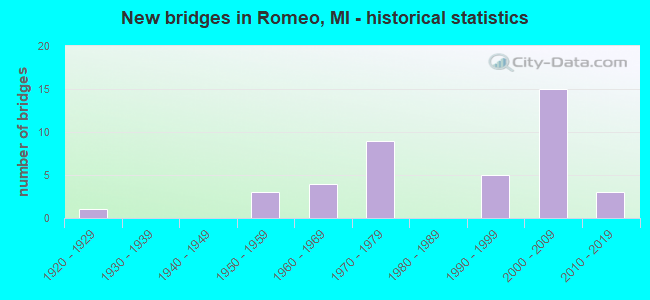
- New bridges - historical statistics
- 11920-1929
- 31950-1959
- 41960-1969
- 91970-1979
- 51990-1999
- 152000-2009
- 32010-2019

- Reconstructed bridges - Historical Statistics
- 11960-1969
- 01970-1979
- 11980-1989
- 01990-1999
- 02000-2009
- 12010-2019


- Bridge Condition - Deck
- 5.3%Excellent
- 5.3%Very good
- 31.6%Good
- 42.1%Satisfactory
- 15.8%Fair

- Bridge Condition - Superstructure
- 31.6%Very good
- 42.1%Good
- 10.5%Satisfactory
- 5.3%Fair
- 5.3%Poor
- 5.3%Serious

- Bridge Condition - Substructure
- 15.8%Very good
- 52.6%Good
- 26.3%Satisfactory
- 5.3%Serious

- Bridge Condition - Channel
- 16.0%Very good
- 12.0%Good
- 48.0%Satisfactory
- 16.0%Fair
- 4.0%Poor
- 4.0%Serious

- Bridge Condition - Culverts
- 14.3%Very good
- 21.4%Good
- 35.7%Satisfactory
- 7.1%Fair
- 14.3%Poor
- 7.1%Serious
Find on map >> Show street view
Structure Number: 267, Location: LEE TWP SEC 9 (Lat: 42.485858, Lng: -86.080864), Route carried "on" structure: County highway , Year Built: 1979, Status: Open, Structure Length: 0.64m (2.10ft), Average Daily Traffic: 538 (year 2020), Truck Traffic: 7%, Average Future Daily Traffic: 800 (year 2040), Design Load: HS 20+Mod, Features Intersected: SCOTT CREEK, Facility Carried by Structure: 55TH STREET
Minimum Vertical Clearance: 30.48m (100.00ft), Kilometerpoint: 3.431, Lanes on structure: 2, Owner: County Highway Agency, Approaching Roadway Width: 9.1m (29.9ft), Material/Design: Wood or Timber, Design/Construction: Slab, Number Of Spans In Main Unit: 1, Length of Maximum Span: 6.1m (20.0ft), Curb-To-Curb Width: 8.4m (27.6ft), Out-to-Out Width: 9.0m (29.5ft)
Condition: Deck: Satisfactory, Superstructure: Satisfactory, Substructure: Satisfactory, Channel: Satisfactory, Operating Rating: 51.5 metric tons, Method Used To Determine Operating Rating: Allowable Stress (AS) rating reported by rating factor (RF) method using MS18 loading, Inventory Rating: 36.6 metric tons, Method Used To Determine Inventory Rating: Allowable Stress (AS) rating reported by rating factor (RF) method using MS18 loading, Structural Evaluation: Equal to present minimum criteria, Deck Geometry: Somewhat better than minimum adequacy, Waterway Adequacy: Equal to present desirable criteria, Approach Roadway Alignment: Equal to present desirable criteria, Designated Inspection Frequency: Every 24 months, Inspection Date: April 2021, Deck Structure Type: Wood or Timber, Wearing Surface/Protective System: Wearing Surface: Bituminous
Find on map >> Show street view
Structure Number: 2671, Location: IN FLINT (Lat: 43.025600, Lng: -83.681000), Route carried "on" structure: City street 2002, Year Built: 1976, Status: Open, Structure Length: 5.14m (16.86ft), Average Daily Traffic: 11,713 (year 1993), Truck Traffic: 7%, Average Future Daily Traffic: 12,942 (year 2013), Design Load: HS 20, Features Intersected: I-475, Facility Carried by Structure: W BD LONGWAY BLVD
Minimum Vertical Clearance: 30.48m (100.00ft), Kilometerpoint: 2.309, Lanes on structure: 4, Lanes under structure: 6, Base Highway Network: Yes (Inventory Route: 149, Subroute: 6), Owner: State Highway Agency, Approaching Roadway Width: 19.5m (64.0ft), Skew: 1 degrees, Material/Design: Steel, Design/Construction: Stringer/Multi-beam, Number Of Spans In Main Unit: 2, Length of Maximum Span: 25.4m (83.3ft), Curb or Sidewalk Widths: Left: 1.8m (5.9ft), Right: 1.8m (5.9ft), Curb-To-Curb Width: 15.8m (51.8ft), Out-to-Out Width: 20.2m (66.3ft)
Condition: Deck: Satisfactory, Superstructure: Very good, Substructure: Good, Operating Rating: 69.3 metric tons, Method Used To Determine Operating Rating: Load Factor (LF) rating reported by rating factor (RF) method using MS18 loading, Inventory Rating: 41.5 metric tons, Method Used To Determine Inventory Rating: Load Factor (LF) rating reported by rating factor (RF) method using MS18 loading, Structural Evaluation: Better than present minimum criteria, Deck Geometry: Meets minimum limits, Underclear: High priority of corrective action, Approach Roadway Alignment: Equal to present desirable criteria, Designated Inspection Frequency: Every 24 months, Inspection Date: July 2020, Deck Structure Type: Concrete Cast-file-Place, Wearing Surface/Protective System: Wearing Surface: Epoxy Overlay
Find on map >> Show street view
Structure Number: 2674, Location: IN CITY OF FLINT (Lat: 43.042889, Lng: -83.676317), Route carried "on" structure: Interstate 475, Year Built: 1977, Status: Open, Structure Length: 4.81m (15.78ft), Average Daily Traffic: 56,000 (year 2007), Truck Traffic: 3%, Average Future Daily Traffic: 66,597 (year 2018), Design Load: HS 25 or greater, Features Intersected: LEITH STREET
Minimum Vertical Clearance: 30.48m (100.00ft), Kilometerpoint: 14.271, Lanes on structure: 6, Lanes under structure: 4, Base Highway Network: Yes (Inventory Route: 149, Subroute: 3), Owner: State Highway Agency, Approaching Roadway Width: 36.5m (119.8ft), Skew: 31 degrees, Material/Design: Steel, Design/Construction: Stringer/Multi-beam, Number Of Spans In Main Unit: 3, Length of Maximum Span: 24.3m (79.7ft), Curb-To-Curb Width: 37.2m (122.0ft), Out-to-Out Width: 37.7m (123.7ft)
Condition: Deck: Satisfactory, Superstructure: Good, Substructure: Satisfactory, Operating Rating: 78.1 metric tons, Method Used To Determine Operating Rating: Load Factor (LF) rating reported by rating factor (RF) method using MS18 loading, Inventory Rating: 46.7 metric tons, Method Used To Determine Inventory Rating: Load Factor (LF) rating reported by rating factor (RF) method using MS18 loading, Structural Evaluation: Equal to present minimum criteria, Deck Geometry: Superior to present desirable criteria, Underclear: Equal to present minimum criteria, Approach Roadway Alignment: Equal to present desirable criteria, Length Of Structure Improvement: 4.82m (15.81ft), Designated Inspection Frequency: Every 16 months, Inspection Date: December 2020, Bridge Improvement Cost: $250,000, Roadway Improvement Cost: $13,000, Total Project Cost: $151,000, Deck Structure Type: Concrete Cast-file-Place, Wearing Surface/Protective System: Wearing Surface: Latex Concrete
Find on map >> Show street view
Structure Number: 602, Location: 1.6 MI N OF ROMEO (Lat: 42.822753, Lng: -83.019950), Route carried "on" structure: County highway , Year Built: 1926, Year Reconstructed: 1971, Status: Open, Structure Length: 0.94m (3.08ft), Average Daily Traffic: 6,560 (year 2005), Truck Traffic: 6%, Average Future Daily Traffic: 8,836 (year 2025), Design Load: H 15, Features Intersected: EAST POND CREEK, Facility Carried by Structure: VAN DYKE(OLD M-53)
Minimum Vertical Clearance: 30.48m (100.00ft), Kilometerpoint: 2.095, Lanes on structure: 2, Owner: County Highway Agency, Approaching Roadway Width: 13.0m (42.7ft), Material/Design: Concrete, Design/Construction: Tee Beam, Number Of Spans In Main Unit: 1, Length of Maximum Span: 9.4m (30.8ft), Curb-To-Curb Width: 13.0m (42.7ft), Out-to-Out Width: 13.2m (43.3ft)
Condition: Deck: Fair, Superstructure: Poor, Substructure: Satisfactory, Channel: Satisfactory, Operating Rating: 52.6 metric tons, Method Used To Determine Operating Rating: Field evaluation and documented engineering judgment, Inventory Rating: 31.4 metric tons, Method Used To Determine Inventory Rating: Field evaluation and documented engineering judgment, Structural Evaluation: Meets minimum limits, Deck Geometry: Somewhat better than minimum adequacy, Waterway Adequacy: Better than present minimum criteria, Approach Roadway Alignment: Equal to present desirable criteria, Designated Inspection Frequency: Every 24 months, Inspection Date: August 2020, Deck Structure Type: Concrete Cast-file-Place, Wearing Surface/Protective System: Wearing Surface: Bituminous
Find on map >> Show street view
Structure Number: 6041, Location: 0.1 MI S OF 33 MILE RD (Lat: 42.816258, Lng: -83.002575), Route carried "on" structure: State highway 53, Year Built: 1990, Status: Open, Structure Length: 1.82m (5.97ft), Average Daily Traffic: 14,182 (year 2007), Truck Traffic: 17%, Average Future Daily Traffic: 19,097 (year 2018), Design Load: HS 20, Features Intersected: EAST POND CREEK
Minimum Vertical Clearance: 30.48m (100.00ft), Kilometerpoint: 31.110, Lanes on structure: 2, Base Highway Network: Yes (Inventory Route: 81, Subroute: 6), Owner: State Highway Agency, Approaching Roadway Width: 17.7m (58.1ft), Skew: 3 degrees, Material/Design: Prestressed concrete, Design/Construction: Stringer/Multi-beam, Number Of Spans In Main Unit: 1, Length of Maximum Span: 16.4m (53.8ft), Curb-To-Curb Width: 14.3m (46.9ft), Out-to-Out Width: 19.9m (65.3ft)
Condition: Deck: Good, Superstructure: Good, Substructure: Satisfactory, Channel: Good, Operating Rating: 75.7 metric tons, Method Used To Determine Operating Rating: Load Factor (LF), Inventory Rating: 42.8 metric tons, Method Used To Determine Inventory Rating: Load Factor (LF), Structural Evaluation: Equal to present minimum criteria, Deck Geometry: Superior to present desirable criteria, Waterway Adequacy: Better than present minimum criteria, Approach Roadway Alignment: Equal to present desirable criteria, Designated Inspection Frequency: Every 24 months, Inspection Date: December 2021, Deck Structure Type: Concrete Cast-file-Place, Wearing Surface/Protective System: Wearing Surface: Monolithic Concrete, Deck Protection: Epoxy Coated Reinforcing
Find on map >> Show street view
Structure Number: 6042, Location: 3.0 MI S OF ROMEO (Lat: 42.757575, Lng: -83.013197), Route carried "on" structure: State highway 53, Year Built: 1990, Status: Open, Structure Length: 5.45m (17.88ft), Average Daily Traffic: 17,107 (year 2007), Truck Traffic: 8%, Average Future Daily Traffic: 13,992 (year 2015), Design Load: HS 20, Features Intersected: 29 MILE RD
Minimum Vertical Clearance: 30.48m (100.00ft), Kilometerpoint: 24.358, Lanes on structure: 2, Lanes under structure: 2, Base Highway Network: Yes (Inventory Route: 81, Subroute: 6), Owner: State Highway Agency, Approaching Roadway Width: 13.1m (43.0ft), Skew: 4 degrees, Material/Design: Prestressed concrete, Design/Construction: Stringer/Multi-beam, Number Of Spans In Main Unit: 3, Length of Maximum Span: 31.7m (104.0ft), Curb-To-Curb Width: 14.4m (47.2ft), Out-to-Out Width: 15.4m (50.5ft)
Condition: Deck: Good, Superstructure: Good, Substructure: Satisfactory, Operating Rating: 69.3 metric tons, Method Used To Determine Operating Rating: Load Factor (LF) rating reported by rating factor (RF) method using MS18 loading, Inventory Rating: 42.8 metric tons, Method Used To Determine Inventory Rating: Load Factor (LF) rating reported by rating factor (RF) method using MS18 loading, Structural Evaluation: Equal to present minimum criteria, Deck Geometry: Superior to present desirable criteria, Underclear: Equal to present minimum criteria, Approach Roadway Alignment: Equal to present desirable criteria, Designated Inspection Frequency: Every 24 months, Inspection Date: December 2021, Bridge Improvement Cost: $391,000, Deck Structure Type: Concrete Cast-file-Place, Wearing Surface/Protective System: Wearing Surface: Monolithic Concrete, Deck Protection: Epoxy Coated Reinforcing
Find on map >> Show street view
Structure Number: 6222, Location: 1.9MI EAST OF VAN DYKE (Lat: 42.760022, Lng: -82.981039), Route carried "on" structure: County highway 5068, Year Built: 2017, Status: Open, Structure Length: 0.82m (2.69ft), Average Daily Traffic: 3,715 (year 2017), Truck Traffic: 1%, Average Future Daily Traffic: 5,478 (year 2037), Design Load: Greater than HL93, Features Intersected: HEALY BROOK DRAIN, Facility Carried by Structure: 29 MILE ROAD
Minimum Vertical Clearance: 30.48m (100.00ft), Kilometerpoint: 6.264, Lanes on structure: 2, Owner: County Highway Agency, Approaching Roadway Width: 9.8m (32.2ft), Skew: 2 degrees, Material/Design: Concrete, Design/Construction: Culvert, Number Of Spans In Main Unit: 1, Length of Maximum Span: 7.6m (24.9ft), Curb-To-Curb Width: 9.8m (32.2ft), Out-to-Out Width: 18.3m (60.0ft)
Condition: Channel: Very good, Culverts: Very good, Operating Rating: 48.6 metric tons, Method Used To Determine Operating Rating: Load and Resistance Factor Rating (LRFR) rating reported by rating factor(RF) method using HL-93 loadings, Inventory Rating: 37.6 metric tons, Method Used To Determine Inventory Rating: Load and Resistance Factor Rating (LRFR) rating reported by rating factor(RF) method using HL-93 loadings, Structural Evaluation: Equal to present desirable criteria, Deck Geometry: Meets minimum limits, Waterway Adequacy: Superior to present desirable criteria, Approach Roadway Alignment: Equal to present minimum criteria, Length Of Structure Improvement: 0.98m (3.22ft), Designated Inspection Frequency: Every 24 months, Inspection Date: November 2021, Bridge Improvement Cost: $300,000, Roadway Improvement Cost: $200,000, Wearing Surface/Protective System: Wearing Surface: Bituminous
Find on map >> Show street view
Structure Number: 6223, Location: 0.5MI E OF ROMEO PLANK RD (Lat: 42.760206, Lng: -82.950114), Route carried "on" structure: County highway 5068, Year Built: 2017, Status: Open, Structure Length: 0.65m (2.13ft), Average Daily Traffic: 3,300 (year 2017), Truck Traffic: 1%, Average Future Daily Traffic: 4,000 (year 2037), Design Load: Greater than HL93, Features Intersected: CAMP BROOK DRAIN, Facility Carried by Structure: 29 MILE ROAD
Minimum Vertical Clearance: 30.48m (100.00ft), Kilometerpoint: 8.799, Lanes on structure: 2, Owner: County Highway Agency, Approaching Roadway Width: 7.3m (24.0ft), Skew: 2 degrees, Material/Design: Concrete, Design/Construction: Culvert, Number Of Spans In Main Unit: 1, Length of Maximum Span: 5.9m (19.4ft), Curb-To-Curb Width: 9.8m (32.2ft), Out-to-Out Width: 15.8m (51.8ft)
Condition: Channel: Very good, Culverts: Very good, Operating Rating: 47.0 metric tons, Method Used To Determine Operating Rating: Load and Resistance Factor Rating (LRFR) rating reported by rating factor(RF) method using HL-93 loadings, Inventory Rating: 36.3 metric tons, Method Used To Determine Inventory Rating: Load and Resistance Factor Rating (LRFR) rating reported by rating factor(RF) method using HL-93 loadings, Structural Evaluation: Equal to present desirable criteria, Deck Geometry: Meets minimum limits, Waterway Adequacy: Superior to present desirable criteria, Approach Roadway Alignment: Equal to present desirable criteria, Designated Inspection Frequency: Every 24 months, Inspection Date: November 2021, Wearing Surface/Protective System: Wearing Surface: Bituminous
Find on map >> Show street view
Structure Number: 6227, Location: 0.4 MI W OF ROMEO PLANK (Lat: 42.805117, Lng: -82.968322), Route carried "on" structure: County highway 5080, Year Built: 2016, Status: Open, Structure Length: 2.80m (9.19ft), Average Daily Traffic: 16,300 (year 2015), Truck Traffic: 5%, Average Future Daily Traffic: 17,600 (year 2035), Design Load: Greater than HL93, Features Intersected: N BR CLINTON RIVER, Facility Carried by Structure: 32 MILE ROAD
Minimum Vertical Clearance: 30.48m (100.00ft), Kilometerpoint: 10.825, Lanes on structure: 2, Owner: County Highway Agency, Approaching Roadway Width: 12.2m (40.0ft), Skew: 3 degrees, Material/Design: Prestressed concrete, Design/Construction: Box Beam or Girders - Single/Spread, Number Of Spans In Main Unit: 1, Length of Maximum Span: 27.1m (88.9ft), Curb-To-Curb Width: 12.2m (40.0ft), Out-to-Out Width: 12.9m (42.3ft)
Condition: Deck: Very good, Superstructure: Very good, Substructure: Very good, Channel: Very good, Operating Rating: 69.3 metric tons, Method Used To Determine Operating Rating: Load and Resistance Factor Rating (LRFR) rating reported by rating factor(RF) method using HL-93 loadings, Inventory Rating: 51.5 metric tons, Method Used To Determine Inventory Rating: Load and Resistance Factor Rating (LRFR) rating reported by rating factor(RF) method using HL-93 loadings, Structural Evaluation: Equal to present desirable criteria, Deck Geometry: Somewhat better than minimum adequacy, Waterway Adequacy: Superior to present desirable criteria, Approach Roadway Alignment: Equal to present desirable criteria, Designated Inspection Frequency: Every 24 months, Inspection Date: October 2020, Deck Structure Type: Concrete Cast-file-Place, Wearing Surface/Protective System: Wearing Surface: Monolithic Concrete, Deck Protection: Epoxy Coated Reinforcing
Find on map >> Show street view
Structure Number: 6233, Location: 0.2 MI WEST OF MCFADDEN (Lat: 42.849125, Lng: -82.978739), Route carried "on" structure: County highway 5090, Year Built: 1995, Status: Open, Structure Length: 2.43m (7.97ft), Average Daily Traffic: 1,680 (year 2010), Truck Traffic: 3%, Average Future Daily Traffic: 2,497 (year 2030), Design Load: HS 25 or greater, Features Intersected: N. BRANCH CLINTON RIVER, Facility Carried by Structure: ARMADA CENTER RD
Minimum Vertical Clearance: 30.48m (100.00ft), Kilometerpoint: 0.771, Lanes on structure: 2, Owner: County Highway Agency, Approaching Roadway Width: 8.0m (26.2ft), Skew: 1 degrees, Material/Design: Prestressed concrete, Design/Construction: Stringer/Multi-beam, Number Of Spans In Main Unit: 1, Length of Maximum Span: 23.1m (75.8ft), Curb-To-Curb Width: 12.0m (39.4ft), Out-to-Out Width: 13.2m (43.3ft)
Condition: Deck: Good, Superstructure: Very good, Substructure: Very good, Channel: Satisfactory, Operating Rating: 96.2 metric tons, Method Used To Determine Operating Rating: Load Factor (LF) rating reported by rating factor (RF) method using MS18 loading, Inventory Rating: 57.7 metric tons, Method Used To Determine Inventory Rating: Load Factor (LF) rating reported by rating factor (RF) method using MS18 loading, Structural Evaluation: Equal to present desirable criteria, Deck Geometry: Equal to present minimum criteria, Waterway Adequacy: Better than present minimum criteria, Approach Roadway Alignment: Equal to present desirable criteria, Designated Inspection Frequency: Every 24 months, Inspection Date: July 2021, Deck Structure Type: Concrete Cast-file-Place, Wearing Surface/Protective System: Wearing Surface: Monolithic Concrete, Deck Protection: Epoxy Coated Reinforcing
Find on map >> Show street view
Structure Number: 6234, Location: 0.2 MI W OF ROMEO PLANK (Lat: 42.849164, Lng: -82.969253), Route carried "on" structure: County highway 5090, Year Built: 1975, Status: Open, Structure Length: 0.88m (2.89ft), Average Daily Traffic: 1,600 (year 2010), Truck Traffic: 3%, Average Future Daily Traffic: 2,377 (year 2030), Design Load: H 20, Features Intersected: NEWLAND DRAIN, Facility Carried by Structure: ARMADA CENTER RD
Minimum Vertical Clearance: 30.48m (100.00ft), Kilometerpoint: 1.545, Lanes on structure: 2, Owner: County Highway Agency, Approaching Roadway Width: 12.0m (39.4ft), Skew: 2 degrees, Material/Design: Steel, Design/Construction: Culvert, Number Of Spans In Main Unit: 2, Length of Maximum Span: 3.9m (12.8ft)
Condition: Channel: Satisfactory, Culverts: Satisfactory, Operating Rating: 97.2 metric tons, Method Used To Determine Operating Rating: Load Factor (LF) rating reported by rating factor (RF) method using MS18 loading, Inventory Rating: 97.2 metric tons, Method Used To Determine Inventory Rating: Load Factor (LF) rating reported by rating factor (RF) method using MS18 loading, Structural Evaluation: Equal to present minimum criteria, Waterway Adequacy: Equal to present minimum criteria, Approach Roadway Alignment: Equal to present desirable criteria, Designated Inspection Frequency: Every 24 months, Inspection Date: July 2021
Find on map >> Show street view
Structure Number: 6262, Location: 0.7 MI S OF 32 MILE ROAD (Lat: 42.795236, Lng: -82.962333), Route carried "on" structure: County highway 5037, Year Built: 1964, Year Reconstructed: 2019, Status: Open, Structure Length: 1.98m (6.50ft), Average Daily Traffic: 5,760 (year 2009), Truck Traffic: 3%, Average Future Daily Traffic: 8,559 (year 2029), Design Load: HS 20, Features Intersected: N B CLINTON RIVER, Facility Carried by Structure: ROMEO PLANK RD
Minimum Vertical Clearance: 30.48m (100.00ft), Kilometerpoint: 10.498, Lanes on structure: 2, Owner: County Highway Agency, Approaching Roadway Width: 12.0m (39.4ft), Skew: 3 degrees, Material/Design: Steel, Design/Construction: Stringer/Multi-beam, Number Of Spans In Main Unit: 1, Length of Maximum Span: 19.2m (63.0ft), Curb or Sidewalk Widths: Left: 0.0m, Right: 1.7m (5.6ft), Curb-To-Curb Width: 9.0m (29.5ft), Out-to-Out Width: 11.3m (37.1ft)
Condition: Deck: Excellent, Superstructure: Very good, Substructure: Good, Channel: Good, Operating Rating: 53.1 metric tons, Method Used To Determine Operating Rating: Load and Resistance Factor Rating (LRFR) rating reported by rating factor(RF) method using HL-93 loadings, Inventory Rating: 40.8 metric tons, Method Used To Determine Inventory Rating: Load and Resistance Factor Rating (LRFR) rating reported by rating factor(RF) method using HL-93 loadings, Structural Evaluation: Better than present minimum criteria, Deck Geometry: High priority of replacement, Waterway Adequacy: Superior to present desirable criteria, Approach Roadway Alignment: Equal to present desirable criteria, Designated Inspection Frequency: Every 24 months, Inspection Date: July 2021, Deck Structure Type: Concrete Cast-file-Place, Wearing Surface/Protective System: Wearing Surface: Low Slump Concrete
Find on map >> Show street view
Structure Number: 6285, Location: 0.2 MI EAST OF POWELL RD (Lat: 42.819681, Lng: -82.976411), Route carried "on" structure: County highway 5027, Year Built: 1955, Status: Posted for load, Structure Length: 1.15m (3.77ft), Average Daily Traffic: 388 (year 2009), Truck Traffic: 2%, Average Future Daily Traffic: 636 (year 2029), Design Load: H 15, Features Intersected: N B CLINTON RIVER, Facility Carried by Structure: 33 MILE ROAD
Minimum Vertical Clearance: 30.48m (100.00ft), Kilometerpoint: 2.787, Lanes on structure: 2, Owner: County Highway Agency, Approaching Roadway Width: 8.0m (26.2ft), Material/Design: Steel, Design/Construction: Stringer/Multi-beam, Number Of Spans In Main Unit: 1, Length of Maximum Span: 10.9m (35.8ft), Curb-To-Curb Width: 6.4m (21.0ft), Out-to-Out Width: 9.0m (29.5ft)
Condition: Deck: Fair, Superstructure: Serious, Substructure: Serious, Channel: Serious, Operating Rating: 53.8 metric tons, Method Used To Determine Operating Rating: Load Factor (LF) rating reported by rating factor (RF) method using MS18 loading, Inventory Rating: 32.4 metric tons, Method Used To Determine Inventory Rating: Load Factor (LF) rating reported by rating factor (RF) method using MS18 loading, Structural Evaluation: High priority of corrective action, Deck Geometry: Meets minimum limits, Waterway Adequacy: Somewhat better than minimum adequacy, Approach Roadway Alignment: Better than present minimum criteria, Bridge Posting: Required (Relationship of Operating Rating to Maximum Legal Load: > 39.9% below), Length Of Structure Improvement: 1.52m (4.99ft), Designated Inspection Frequency: Every 12 months, Inspection Date: September 2021, Bridge Improvement Cost: $200,000, Roadway Improvement Cost: $120,000, Total Project Cost: $320,000, Deck Structure Type: Corrugated Steel, Wearing Surface/Protective System: Wearing Surface: Bituminous
Find on map >> Show street view
Structure Number: 6288, Location: 2.1 MI EAST OF VAN DYKE (Lat: 42.834417, Lng: -82.980914), Route carried "on" structure: County highway , Year Built: 1991, Status: Open, Structure Length: 1.73m (5.68ft), Average Daily Traffic: 331 (year 2009), Truck Traffic: 2%, Average Future Daily Traffic: 543 (year 2029), Design Load: HS 20, Features Intersected: NORTH BRANCH CLINTON R, Facility Carried by Structure: 34 MILE ROAD
Minimum Vertical Clearance: 30.48m (100.00ft), Kilometerpoint: 9.809, Lanes on structure: 2, Owner: County Highway Agency, Approaching Roadway Width: 12.0m (39.4ft), Material/Design: Prestressed concrete, Design/Construction: Box Beam or Girders - Multiple, Number Of Spans In Main Unit: 1, Length of Maximum Span: 16.7m (54.8ft), Curb-To-Curb Width: 12.0m (39.4ft), Out-to-Out Width: 13.2m (43.3ft)
Condition: Deck: Satisfactory, Superstructure: Good, Substructure: Good, Channel: Fair, Operating Rating: 59.0 metric tons, Method Used To Determine Operating Rating: Load Factor (LF) rating reported by rating factor (RF) method using MS18 loading, Inventory Rating: 35.3 metric tons, Method Used To Determine Inventory Rating: Load Factor (LF) rating reported by rating factor (RF) method using MS18 loading, Structural Evaluation: Better than present minimum criteria, Deck Geometry: Superior to present desirable criteria, Waterway Adequacy: Meets minimum limits, Approach Roadway Alignment: Equal to present desirable criteria, Designated Inspection Frequency: Every 24 months, Inspection Date: July 2020, Deck Structure Type: Concrete Precast Panels, Wearing Surface/Protective System: Wearing Surface: Bituminous, Membrane: Built-up
Find on map >> Show street view
Structure Number: 629, Location: 0.1 MI E OF ROMEO PLANK (Lat: 42.863847, Lng: -82.964217), Route carried "on" structure: County highway , Year Built: 1971, Status: Open, Structure Length: 1.03m (3.38ft), Average Daily Traffic: 70 (year 2010), Truck Traffic: 2%, Average Future Daily Traffic: 126 (year 2030), Design Load: H 20, Features Intersected: NEWLAND DRAIN, Facility Carried by Structure: IRWIN ROAD
Minimum Vertical Clearance: 30.48m (100.00ft), Kilometerpoint: 0.074, Lanes on structure: 2, Owner: County Highway Agency, Approaching Roadway Width: 6.0m (19.7ft), Material/Design: Steel, Design/Construction: Culvert, Number Of Spans In Main Unit: 3, Length of Maximum Span: 2.7m (8.9ft)
Condition: Channel: Fair, Culverts: Fair, Operating Rating: 97.2 metric tons, Method Used To Determine Operating Rating: Load Factor (LF) rating reported by rating factor (RF) method using MS18 loading, Inventory Rating: 93.6 metric tons, Method Used To Determine Inventory Rating: Load Factor (LF) rating reported by rating factor (RF) method using MS18 loading, Structural Evaluation: Somewhat better than minimum adequacy, Waterway Adequacy: Equal to present minimum criteria, Approach Roadway Alignment: Equal to present desirable criteria, Designated Inspection Frequency: Every 24 months, Inspection Date: July 2020
Find on map >> Show street view
Structure Number: 6297, Location: 0.2 MI N OF 34 MILE ROAD (Lat: 42.838108, Lng: -82.973950), Route carried "on" structure: County highway , Year Built: 1953, Status: Open, Structure Length: 0.61m (2.00ft), Average Daily Traffic: 186 (year 2010), Truck Traffic: 2%, Average Future Daily Traffic: 277 (year 2030), Design Load: H 20, Features Intersected: NEWLAND DRAIN, Facility Carried by Structure: MC FADDEN ROAD
Minimum Vertical Clearance: 30.48m (100.00ft), Kilometerpoint: 2.041, Lanes on structure: 2, Owner: County Highway Agency, Approaching Roadway Width: 6.0m (19.7ft), Material/Design: Steel, Design/Construction: Culvert, Number Of Spans In Main Unit: 2, Length of Maximum Span: 2.7m (8.9ft)
Condition: Channel: Satisfactory, Culverts: Poor, Operating Rating: 75.2 metric tons, Method Used To Determine Operating Rating: Load Factor (LF) rating reported by rating factor (RF) method using MS18 loading, Inventory Rating: 70.3 metric tons, Method Used To Determine Inventory Rating: Load Factor (LF) rating reported by rating factor (RF) method using MS18 loading, Structural Evaluation: Meets minimum limits, Waterway Adequacy: Better than present minimum criteria, Approach Roadway Alignment: Equal to present desirable criteria, Length Of Structure Improvement: 0.80m (2.62ft), Designated Inspection Frequency: Every 12 months, Inspection Date: November 2021, Bridge Improvement Cost: $280,000, Roadway Improvement Cost: $160,000
Find on map >> Show street view
Structure Number: 63, Location: 0.2 MI SOUTH OF IRWIN RD (Lat: 42.860567, Lng: -82.964975), Route carried "on" structure: County highway , Year Built: 1971, Status: Posted for load, Structure Length: 1.03m (3.38ft), Average Daily Traffic: 260 (year 2010), Truck Traffic: 2%, Average Future Daily Traffic: 386 (year 2030), Design Load: H 20, Features Intersected: NEWLAND DRAIN, Facility Carried by Structure: ROMEO PLANK ROAD
Minimum Vertical Clearance: 30.48m (100.00ft), Kilometerpoint: 17.758, Lanes on structure: 2, Owner: County Highway Agency, Approaching Roadway Width: 7.0m (23.0ft), Material/Design: Steel, Design/Construction: Culvert, Number Of Spans In Main Unit: 3, Length of Maximum Span: 2.7m (8.9ft)
Condition: Channel: Satisfactory, Culverts: Poor, Operating Rating: 17.2 metric tons, Method Used To Determine Operating Rating: Load Factor (LF) rating reported by rating factor (RF) method using MS18 loading, Inventory Rating: 10.4 metric tons, Method Used To Determine Inventory Rating: Load Factor (LF) rating reported by rating factor (RF) method using MS18 loading, Structural Evaluation: High priority of corrective action, Waterway Adequacy: Better than present minimum criteria, Approach Roadway Alignment: Equal to present desirable criteria, Bridge Posting: Required (Relationship of Operating Rating to Maximum Legal Load: 0.1 - 9.9% below), Designated Inspection Frequency: Every 12 months, Inspection Date: August 2021
Find on map >> Show street view
Structure Number: 6301, Location: 1.1 MI WEST OF VAN DYKE (Lat: 42.809281, Lng: -83.043950), Route carried "on" structure: County highway , Year Built: 2003, Status: Open, Structure Length: 1.77m (5.81ft), Average Daily Traffic: 398 (year 2009), Truck Traffic: 3%, Average Future Daily Traffic: 719 (year 2029), Design Load: HS 20, Features Intersected: EAST MILL LAKE OUTLET, Facility Carried by Structure: GATES ROAD
Minimum Vertical Clearance: 30.48m (100.00ft), Kilometerpoint: 2.976, Lanes on structure: 2, Owner: County Highway Agency, Approaching Roadway Width: 12.2m (40.0ft), Material/Design: Prestressed concrete, Design/Construction: Box Beam or Girders - Multiple, Number Of Spans In Main Unit: 1, Length of Maximum Span: 17.3m (56.8ft), Curb-To-Curb Width: 12.2m (40.0ft), Out-to-Out Width: 13.4m (44.0ft)
Condition: Deck: Good, Superstructure: Very good, Substructure: Very good, Channel: Good, Operating Rating: 87.2 metric tons, Method Used To Determine Operating Rating: Load Factor (LF) rating reported by rating factor (RF) method using MS18 loading, Inventory Rating: 52.2 metric tons, Method Used To Determine Inventory Rating: Load Factor (LF) rating reported by rating factor (RF) method using MS18 loading, Structural Evaluation: Equal to present desirable criteria, Waterway Adequacy: Superior to present desirable criteria, Approach Roadway Alignment: Equal to present minimum criteria, Designated Inspection Frequency: Every 24 months, Inspection Date: May 2020, Deck Structure Type: Concrete Cast-file-Place, Wearing Surface/Protective System: Wearing Surface: Monolithic Concrete, Deck Protection: Epoxy Coated Reinforcing
Find on map >> Show street view
Structure Number: 6302, Location: JUST WEST OF CAMP GROUND (Lat: 42.816747, Lng: -83.040444), Route carried "on" structure: County highway , Year Built: 1969, Status: Open, Structure Length: 0.73m (2.40ft), Average Daily Traffic: 240 (year 2005), Truck Traffic: 2%, Average Future Daily Traffic: 357 (year 2025), Design Load: H 20, Features Intersected: EAST MILL LAKE OUTLET, Facility Carried by Structure: 33 MILE ROAD
Minimum Vertical Clearance: 30.48m (100.00ft), Kilometerpoint: 1.106, Lanes on structure: 2, Owner: County Highway Agency, Approaching Roadway Width: 6.0m (19.7ft), Material/Design: Steel, Design/Construction: Culvert, Number Of Spans In Main Unit: 2, Length of Maximum Span: 3.3m (10.8ft)
Condition: Channel: Satisfactory, Culverts: Satisfactory, Operating Rating: 97.2 metric tons, Method Used To Determine Operating Rating: Load Factor (LF) rating reported by rating factor (RF) method using MS18 loading, Inventory Rating: 97.2 metric tons, Method Used To Determine Inventory Rating: Load Factor (LF) rating reported by rating factor (RF) method using MS18 loading, Structural Evaluation: Equal to present minimum criteria, Waterway Adequacy: Equal to present minimum criteria, Approach Roadway Alignment: Equal to present desirable criteria, Designated Inspection Frequency: Every 24 months, Inspection Date: July 2021
Find on map >> Show street view
Structure Number: 6305, Location: 300 FT NORTH OF 33 MILE (Lat: 42.817714, Lng: -83.039486), Route carried "on" structure: County highway , Year Built: 1969, Status: Open, Structure Length: 0.73m (2.40ft), Average Daily Traffic: 340 (year 2009), Truck Traffic: 2%, Average Future Daily Traffic: 505 (year 2029), Design Load: H 20, Features Intersected: EAST MILL LAKE OUTLET, Facility Carried by Structure: CAMP GROUND ROAD
Minimum Vertical Clearance: 30.48m (100.00ft), Kilometerpoint: 9.375, Lanes on structure: 2, Owner: County Highway Agency, Approaching Roadway Width: 9.0m (29.5ft), Skew: 3 degrees, Material/Design: Steel, Design/Construction: Culvert, Number Of Spans In Main Unit: 2, Length of Maximum Span: 3.3m (10.8ft)
Condition: Channel: Satisfactory, Culverts: Satisfactory, Operating Rating: 64.5 metric tons, Method Used To Determine Operating Rating: Load Factor (LF) rating reported by rating factor (RF) method using MS18 loading, Inventory Rating: 38.6 metric tons, Method Used To Determine Inventory Rating: Load Factor (LF) rating reported by rating factor (RF) method using MS18 loading, Structural Evaluation: Equal to present minimum criteria, Waterway Adequacy: Better than present minimum criteria, Approach Roadway Alignment: Somewhat better than minimum adequacy, Designated Inspection Frequency: Every 24 months, Inspection Date: July 2021
Find on map >> Show street view
Structure Number: 6306, Location: AT MCVICAR AND 33 MILE RD (Lat: 42.817833, Lng: -83.009842), Route carried "on" structure: County highway 5027, Year Built: 1955, Status: Posted for load, Structure Length: 0.70m (2.30ft), Average Daily Traffic: 1,380 (year 2009), Truck Traffic: 3%, Average Future Daily Traffic: 2,262 (year 2029), Design Load: H 15, Features Intersected: EAST POND CREEK, Facility Carried by Structure: MCVICAR ROAD
Minimum Vertical Clearance: 30.48m (100.00ft), Kilometerpoint: 0.882, Lanes on structure: 2, Owner: County Highway Agency, Approaching Roadway Width: 9.0m (29.5ft), Material/Design: Steel, Design/Construction: Culvert, Number Of Spans In Main Unit: 1, Length of Maximum Span: 7.0m (23.0ft), Curb-To-Curb Width: 7.0m (23.0ft), Out-to-Out Width: 10.4m (34.1ft)
Condition: Channel: Fair, Culverts: Serious, Operating Rating: 16.8 metric tons, Method Used To Determine Operating Rating: Load Factor (LF) rating reported by rating factor (RF) method using MS18 loading, Inventory Rating: 10.0 metric tons, Method Used To Determine Inventory Rating: Load Factor (LF) rating reported by rating factor (RF) method using MS18 loading, Structural Evaluation: High priority of corrective action, Deck Geometry: High priority of corrective action, Waterway Adequacy: Superior to present desirable criteria, Approach Roadway Alignment: Somewhat better than minimum adequacy, Bridge Posting: Required (Relationship of Operating Rating to Maximum Legal Load: 30.0 - 39.9% below), Designated Inspection Frequency: Every 12 months, Inspection Date: August 2021
Find on map >> Show street view
Structure Number: 6366, Location: 0.4 MI W OF ROMEO PLANK (Lat: 42.745467, Lng: -82.967731), Route carried "on" structure: County highway , Year Built: 1972, Status: Open, Structure Length: 0.88m (2.89ft), Average Daily Traffic: 160 (year 2009), Truck Traffic: 2%, Average Future Daily Traffic: 238 (year 2029), Design Load: H 20, Features Intersected: HEALY BROOK DRAIN, Facility Carried by Structure: 28 MILE ROAD
Minimum Vertical Clearance: 30.48m (100.00ft), Kilometerpoint: 10.575, Lanes on structure: 2, Owner: County Highway Agency, Approaching Roadway Width: 8.0m (26.2ft), Skew: 1 degrees, Material/Design: Steel, Design/Construction: Culvert, Number Of Spans In Main Unit: 2, Length of Maximum Span: 3.9m (12.8ft)
Condition: Channel: Satisfactory, Culverts: Satisfactory, Operating Rating: 97.2 metric tons, Method Used To Determine Operating Rating: Load Factor (LF) rating reported by rating factor (RF) method using MS18 loading, Inventory Rating: 62.2 metric tons, Method Used To Determine Inventory Rating: Load Factor (LF) rating reported by rating factor (RF) method using MS18 loading, Structural Evaluation: Equal to present minimum criteria, Waterway Adequacy: Somewhat better than minimum adequacy, Approach Roadway Alignment: Equal to present desirable criteria, Designated Inspection Frequency: Every 24 months, Inspection Date: August 2020
Find on map >> Show street view
Structure Number: 638, Location: 0.4 MI E OF ROMEO PLANK (Lat: 42.789456, Lng: -82.953097), Route carried "on" structure: County highway , Year Built: 1972, Status: Posted for load, Structure Length: 1.64m (5.38ft), Average Daily Traffic: 497 (year 2009), Truck Traffic: 2%, Average Future Daily Traffic: 738 (year 2029), Design Load: HS 20, Features Intersected: N BRANCH CLINTON RIVER, Facility Carried by Structure: 31 MILE ROAD
Minimum Vertical Clearance: 30.48m (100.00ft), Kilometerpoint: 12.479, Lanes on structure: 2, Owner: County Highway Agency, Approaching Roadway Width: 6.1m (20.0ft), Material/Design: Prestressed concrete, Design/Construction: Tee Beam, Number Of Spans In Main Unit: 1, Length of Maximum Span: 15.5m (50.9ft), Curb-To-Curb Width: 6.1m (20.0ft), Out-to-Out Width: 6.8m (22.3ft)
Condition: Deck: Satisfactory, Superstructure: Fair, Substructure: Good, Channel: Fair, Operating Rating: 60.9 metric tons, Method Used To Determine Operating Rating: Load Factor (LF) rating reported by rating factor (RF) method using MS18 loading, Inventory Rating: 36.6 metric tons, Method Used To Determine Inventory Rating: Load Factor (LF) rating reported by rating factor (RF) method using MS18 loading, Structural Evaluation: Somewhat better than minimum adequacy, Deck Geometry: High priority of corrective action, Waterway Adequacy: Somewhat better than minimum adequacy, Approach Roadway Alignment: Somewhat better than minimum adequacy, Bridge Posting: Required (Relationship of Operating Rating to Maximum Legal Load: > 39.9% below), Designated Inspection Frequency: Every 24 months, Inspection Date: May 2020, Deck Structure Type: Concrete Precast Panels, Wearing Surface/Protective System: Wearing Surface: Bituminous
Find on map >> Show street view
Structure Number: 6383, Location: 0.25 MI S OF 28 MILE RD (Lat: 42.740297, Lng: -82.977867), Route carried "on" structure: County highway , Year Built: 1979, Status: Open, Structure Length: 0.71m (2.33ft), Average Daily Traffic: 210 (year 2009), Truck Traffic: 2%, Average Future Daily Traffic: 312 (year 2029), Design Load: H 20, Features Intersected: PRICE BROOK DRAIN, Facility Carried by Structure: HAYES ROAD
Minimum Vertical Clearance: 30.48m (100.00ft), Kilometerpoint: 1.070, Lanes on structure: 2, Owner: County Highway Agency, Approaching Roadway Width: 5.0m (16.4ft), Skew: 3 degrees, Material/Design: Steel, Design/Construction: Culvert, Number Of Spans In Main Unit: 2, Length of Maximum Span: 3.0m (9.8ft)
Condition: Channel: Satisfactory, Culverts: Good, Operating Rating: 97.2 metric tons, Method Used To Determine Operating Rating: Load Factor (LF) rating reported by rating factor (RF) method using MS18 loading, Inventory Rating: 97.2 metric tons, Method Used To Determine Inventory Rating: Load Factor (LF) rating reported by rating factor (RF) method using MS18 loading, Structural Evaluation: Better than present minimum criteria, Waterway Adequacy: Equal to present minimum criteria, Approach Roadway Alignment: Equal to present desirable criteria, Designated Inspection Frequency: Every 24 months, Inspection Date: June 2021
Find on map >> Show street view
Structure Number: 6388, Location: 200 FT NORTH OF 32 MILE (Lat: 42.804406, Lng: -82.980103), Route carried "on" structure: County highway 5027, Year Built: 1964, Year Reconstructed: 1988, Status: Open, Structure Length: 0.79m (2.59ft), Average Daily Traffic: 5,560 (year 2009), Truck Traffic: 3%, Average Future Daily Traffic: 9,113 (year 2029), Design Load: H 20, Features Intersected: EAST POND CREEK, Facility Carried by Structure: POWELL ROAD
Minimum Vertical Clearance: 30.48m (100.00ft), Kilometerpoint: 3.919, Lanes on structure: 3, Owner: County Highway Agency, Approaching Roadway Width: 13.0m (42.7ft), Material/Design: Steel, Design/Construction: Culvert, Number Of Spans In Main Unit: 1, Length of Maximum Span: 7.9m (25.9ft)
Condition: Channel: Poor, Culverts: Satisfactory, Operating Rating: 27.2 metric tons, Method Used To Determine Operating Rating: Load Factor (LF) rating reported by rating factor (RF) method using MS18 loading, Inventory Rating: 16.2 metric tons, Method Used To Determine Inventory Rating: Load Factor (LF) rating reported by rating factor (RF) method using MS18 loading, Structural Evaluation: Meets minimum limits, Waterway Adequacy: Superior to present desirable criteria, Approach Roadway Alignment: Equal to present desirable criteria, Designated Inspection Frequency: Every 24 months, Inspection Date: August 2021
Find on map >> Show street view
Structure Number: 6406, Location: 1.3 MI EAST OF VAN DYKE (Lat: 42.773903, Lng: -82.990950), Route carried "on" structure: County highway , Year Built: 2008, Status: Open, Structure Length: 1.03m (3.38ft), Average Daily Traffic: 350 (year 2009), Truck Traffic: 3%, Average Future Daily Traffic: 632 (year 2029), Design Load: HS 20, Features Intersected: HEALY BROOK DRAIN, Facility Carried by Structure: 30 MILE ROAD
Minimum Vertical Clearance: 30.48m (100.00ft), Kilometerpoint: 1.485, Lanes on structure: 2, Owner: County Highway Agency, Approaching Roadway Width: 12.2m (40.0ft), Skew: 4 degrees, Material/Design: Concrete, Design/Construction: Culvert, Number Of Spans In Main Unit: 1, Length of Maximum Span: 10.3m (33.8ft), Curb-To-Curb Width: 12.2m (40.0ft), Out-to-Out Width: 31.7m (104.0ft)
Condition: Channel: Satisfactory, Culverts: Good, Operating Rating: 57.7 metric tons, Method Used To Determine Operating Rating: Field evaluation and documented engineering judgment, Inventory Rating: 34.6 metric tons, Method Used To Determine Inventory Rating: Field evaluation and documented engineering judgment, Structural Evaluation: Better than present minimum criteria, Deck Geometry: Superior to present desirable criteria, Waterway Adequacy: Better than present minimum criteria, Approach Roadway Alignment: Equal to present desirable criteria, Designated Inspection Frequency: Every 24 months, Inspection Date: July 2021, Deck Structure Type: Concrete Precast Panels, Wearing Surface/Protective System: Wearing Surface: Bituminous, Deck Protection: Other
Find on map >> Show street view
Structure Number: 13012, Location: BRUCE TWP SEC 26-35 (Lat: 42.817803, Lng: -83.003553), Route carried "on" structure: County highway , Year Built: 2002, Status: Open, Structure Length: 12.12m (39.76ft), Average Daily Traffic: 2,000 (year 2002), Truck Traffic: 3%, Average Future Daily Traffic: 2,000 (year 2025), Design Load: HS 25 or greater, Features Intersected: M-53, Facility Carried by Structure: 33 MILE RD
Minimum Vertical Clearance: 30.48m (100.00ft), Kilometerpoint: 0.552, Lanes on structure: 2, Lanes under structure: 4, Owner: State Highway Agency, Approaching Roadway Width: 12.0m (39.4ft), Skew: 4 degrees, Material/Design: Prestressed concrete, Design/Construction: Box Beam or Girders - Multiple, Number Of Spans In Main Unit: 4, Length of Maximum Span: 42.3m (138.8ft), Curb-To-Curb Width: 13.2m (43.3ft), Out-to-Out Width: 14.2m (46.6ft)
Condition: Deck: Fair, Superstructure: Satisfactory, Substructure: Good, Operating Rating: 82.3 metric tons, Method Used To Determine Operating Rating: Load Factor (LF), Inventory Rating: 42.7 metric tons, Method Used To Determine Inventory Rating: Load Factor (LF), Structural Evaluation: Equal to present minimum criteria, Deck Geometry: Better than present minimum criteria, Underclear: Better than present minimum criteria, Approach Roadway Alignment: Equal to present desirable criteria, Designated Inspection Frequency: Every 24 months, Inspection Date: December 2021, Deck Structure Type: Concrete Cast-file-Place, Wearing Surface/Protective System: Wearing Surface: Monolithic Concrete, Deck Protection: Epoxy Coated Reinforcing
Find on map >> Show street view
Structure Number: 13015, Location: WASHINGTON SEC TWP 22-27 (Lat: 42.743283, Lng: -83.021447), Route carried "on" structure: County highway , Year Built: 2002, Status: Open, Structure Length: 9.97m (32.71ft), Truck Traffic: 5%, Average Future Daily Traffic: 1,000 (year 2025), Design Load: HS 25 or greater, Features Intersected: M-53, Facility Carried by Structure: 28 MILE RD
Minimum Vertical Clearance: 30.48m (100.00ft), Kilometerpoint: 6.166, Lanes on structure: 2, Lanes under structure: 4, Owner: State Highway Agency, Approaching Roadway Width: 13.2m (43.3ft), Skew: 1 degrees, Material/Design: Prestressed concrete, Design/Construction: Box Beam or Girders - Multiple, Number Of Spans In Main Unit: 4, Length of Maximum Span: 34.2m (112.2ft), Curb-To-Curb Width: 13.2m (43.3ft), Out-to-Out Width: 14.2m (46.6ft)
Condition: Deck: Good, Superstructure: Good, Substructure: Good, Operating Rating: 80.6 metric tons, Method Used To Determine Operating Rating: Load Factor (LF), Inventory Rating: 48.3 metric tons, Method Used To Determine Inventory Rating: Load Factor (LF), Structural Evaluation: Better than present minimum criteria, Deck Geometry: Superior to present desirable criteria, Underclear: Equal to present minimum criteria, Approach Roadway Alignment: Equal to present desirable criteria, Designated Inspection Frequency: Every 24 months, Inspection Date: December 2021, Deck Structure Type: Concrete Cast-file-Place, Wearing Surface/Protective System: Wearing Surface: Monolithic Concrete, Deck Protection: Epoxy Coated Reinforcing
Find on map >> Show street view
Structure Number: 13018, Location: WASHINGTON TWP SEC 14-23 (Lat: 42.757586, Lng: -83.012583), Route carried "on" structure: State highway 53, Year Built: 2002, Status: Open, Structure Length: 7.25m (23.79ft), Average Daily Traffic: 17,107 (year 2007), Truck Traffic: 7%, Average Future Daily Traffic: 27,000 (year 2025), Design Load: HS 25 or greater, Features Intersected: 29 MILE RD
Minimum Vertical Clearance: 30.48m (100.00ft), Kilometerpoint: 24.345, Lanes on structure: 2, Lanes under structure: 2, Base Highway Network: Yes (Inventory Route: 421, Subroute: 8), Owner: State Highway Agency, Approaching Roadway Width: 13.8m (45.3ft), Skew: 4 degrees, Material/Design: Prestressed concrete, Design/Construction: Stringer/Multi-beam, Number Of Spans In Main Unit: 3, Length of Maximum Span: 31.7m (104.0ft), Curb-To-Curb Width: 13.8m (45.3ft), Out-to-Out Width: 14.8m (48.6ft)
Condition: Deck: Satisfactory, Superstructure: Very good, Substructure: Good, Operating Rating: 88.6 metric tons, Method Used To Determine Operating Rating: Load Factor (LF), Inventory Rating: 44.4 metric tons, Method Used To Determine Inventory Rating: Load Factor (LF), Structural Evaluation: Better than present minimum criteria, Deck Geometry: Superior to present desirable criteria, Underclear: Superior to present desirable criteria, Approach Roadway Alignment: Equal to present desirable criteria, Designated Inspection Frequency: Every 24 months, Inspection Date: December 2021, Deck Structure Type: Concrete Cast-file-Place, Wearing Surface/Protective System: Wearing Surface: Monolithic Concrete, Deck Protection: Epoxy Coated Reinforcing
Find on map >> Show street view
Structure Number: 13021, Location: WASHINGTON TWP SEC 2-11 (Lat: 42.786797, Lng: -83.005228), Route carried "on" structure: State highway 53, Year Built: 2002, Status: Open, Structure Length: 4.16m (13.65ft), Average Daily Traffic: 17,107 (year 2007), Truck Traffic: 6%, Average Future Daily Traffic: 20,000 (year 2025), Design Load: HS 25 or greater, Features Intersected: 31 MILE RD
Minimum Vertical Clearance: 30.48m (100.00ft), Kilometerpoint: 27.725, Lanes on structure: 2, Lanes under structure: 2, Base Highway Network: Yes (Inventory Route: 421, Subroute: 8), Owner: State Highway Agency, Approaching Roadway Width: 13.8m (45.3ft), Skew: 2 degrees, Material/Design: Prestressed concrete, Design/Construction: Box Beam or Girders - Multiple, Number Of Spans In Main Unit: 3, Length of Maximum Span: 17.2m (56.4ft), Curb-To-Curb Width: 13.8m (45.3ft), Out-to-Out Width: 14.8m (48.6ft)
Condition: Deck: Satisfactory, Superstructure: Good, Substructure: Good, Operating Rating: 76.3 metric tons, Method Used To Determine Operating Rating: Load Factor (LF), Inventory Rating: 44.2 metric tons, Method Used To Determine Inventory Rating: Load Factor (LF), Structural Evaluation: Better than present minimum criteria, Deck Geometry: Superior to present desirable criteria, Underclear: Better than present minimum criteria, Approach Roadway Alignment: Equal to present desirable criteria, Designated Inspection Frequency: Every 24 months, Inspection Date: December 2021, Deck Structure Type: Concrete Cast-file-Place, Wearing Surface/Protective System: Wearing Surface: Monolithic Concrete, Deck Protection: Epoxy Coated Reinforcing
Find on map >> Show street view
Structure Number: 13022, Location: WASHINGTON TWP SEC 2-11 (Lat: 42.786789, Lng: -83.005711), Route carried "on" structure: State highway 53, Year Built: 2002, Status: Open, Structure Length: 4.16m (13.65ft), Average Daily Traffic: 17,107 (year 2007), Truck Traffic: 6%, Average Future Daily Traffic: 13,000 (year 2025), Design Load: HS 25 or greater, Features Intersected: 31 MILE RD
Minimum Vertical Clearance: 30.48m (100.00ft), Kilometerpoint: 27.743, Lanes on structure: 2, Lanes under structure: 2, Base Highway Network: Yes (Inventory Route: 81, Subroute: 6), Owner: State Highway Agency, Approaching Roadway Width: 13.8m (45.3ft), Skew: 2 degrees, Material/Design: Prestressed concrete, Design/Construction: Box Beam or Girders - Multiple, Number Of Spans In Main Unit: 3, Length of Maximum Span: 17.2m (56.4ft), Curb-To-Curb Width: 13.8m (45.3ft), Out-to-Out Width: 14.8m (48.6ft)
Condition: Deck: Satisfactory, Superstructure: Good, Substructure: Good, Operating Rating: 81.1 metric tons, Method Used To Determine Operating Rating: Load Factor (LF), Inventory Rating: 48.5 metric tons, Method Used To Determine Inventory Rating: Load Factor (LF), Structural Evaluation: Better than present minimum criteria, Deck Geometry: Superior to present desirable criteria, Underclear: Better than present minimum criteria, Approach Roadway Alignment: Equal to present desirable criteria, Designated Inspection Frequency: Every 24 months, Inspection Date: December 2021, Deck Structure Type: Concrete Cast-file-Place, Wearing Surface/Protective System: Wearing Surface: Monolithic Concrete, Deck Protection: Epoxy Coated Reinforcing
Find on map >> Show street view
Structure Number: 13038, Location: BRUCE TWP SEC 35-36 (Lat: 42.816233, Lng: -83.002061), Route carried "on" structure: State highway 53, Year Built: 2002, Status: Open, Structure Length: 2.30m (7.55ft), Average Daily Traffic: 14,182 (year 2007), Truck Traffic: 8%, Average Future Daily Traffic: 15,000 (year 2025), Design Load: HS 25 or greater, Features Intersected: EAST POND CREEK
Minimum Vertical Clearance: 30.48m (100.00ft), Kilometerpoint: 31.086, Lanes on structure: 2, Base Highway Network: Yes (Inventory Route: 421, Subroute: 8), Owner: State Highway Agency, Approaching Roadway Width: 16.8m (55.1ft), Skew: 3 degrees, Material/Design: Prestressed concrete, Design/Construction: Stringer/Multi-beam, Number Of Spans In Main Unit: 1, Length of Maximum Span: 21.0m (68.9ft), Curb-To-Curb Width: 17.5m (57.4ft), Out-to-Out Width: 18.5m (60.7ft)
Condition: Deck: Good, Superstructure: Good, Substructure: Good, Channel: Very good, Operating Rating: 89.4 metric tons, Method Used To Determine Operating Rating: Load Factor (LF) rating reported by rating factor (RF) method using MS18 loading, Inventory Rating: 46.7 metric tons, Method Used To Determine Inventory Rating: Load Factor (LF) rating reported by rating factor (RF) method using MS18 loading, Structural Evaluation: Better than present minimum criteria, Deck Geometry: Superior to present desirable criteria, Waterway Adequacy: Equal to present desirable criteria, Approach Roadway Alignment: Equal to present desirable criteria, Designated Inspection Frequency: Every 24 months, Inspection Date: December 2021, Deck Structure Type: Concrete Cast-file-Place, Wearing Surface/Protective System: Wearing Surface: Monolithic Concrete, Deck Protection: Epoxy Coated Reinforcing
Find on map >> Show street view
Structure Number: 13573, Location: 0.2 MI S OF 29 MILE RD (Lat: 42.754167, Lng: -83.003722), Route carried "on" structure: County highway , Year Built: 2002, Status: Open, Structure Length: 0.74m (2.43ft), Average Daily Traffic: 150 (year 2007), Average Future Daily Traffic: 165 (year 2022), Design Load: HS 20, Features Intersected: PRICE BROOK DRAIN, Facility Carried by Structure: CRIMSON DRIVE
Minimum Vertical Clearance: 30.48m (100.00ft), Kilometerpoint: 0.398, Lanes on structure: 2, Owner: County Highway Agency, Approaching Roadway Width: 8.5m (27.9ft), Skew: 1 degrees, Material/Design: Concrete, Design/Construction: Culvert, Number Of Spans In Main Unit: 1, Length of Maximum Span: 7.4m (24.3ft)
Condition: Channel: Satisfactory, Culverts: Good, Operating Rating: 56.8 metric tons, Method Used To Determine Operating Rating: Field evaluation and documented engineering judgment, Inventory Rating: 34.0 metric tons, Method Used To Determine Inventory Rating: Field evaluation and documented engineering judgment, Structural Evaluation: Better than present minimum criteria, Waterway Adequacy: Equal to present desirable criteria, Approach Roadway Alignment: Equal to present desirable criteria, Designated Inspection Frequency: Every 24 months, Inspection Date: August 2020, Wearing Surface/Protective System: Wearing Surface: Bituminous
Find on map >> Show street view
Structure Number: 6042, Location: 3.0 MI S OF ROMEO (Lat: 42.757575, Lng: -83.013197), Route carried "under" structure: County highway , Year Built: 1990, Structure Length: 0. m, Average Daily Traffic: 4,520 (year 1996), Truck Traffic: 3%, Features Intersected: 29 MILE RD, Facility Carried by Structure: M-53 SB
Minimum Vertical Clearance: 4.50m (14.76ft), Kilometerpoint: 3.610, Lanes on structure: 2, Lanes under structure: 2, Material/Design: Prestressed concrete, Design/Construction: Stringer/Multi-beam, Length of Maximum Span: 31.7m (104.0ft)
Find on map >> Show street view
Structure Number: 13012, Location: BRUCE TWP SEC 26-35 (Lat: 42.817803, Lng: -83.003553), Route carried "under" structure: State highway 53, Year Built: 2002, Structure Length: 0. m, Average Daily Traffic: 28,364 (year 2007), Truck Traffic: 7%, Features Intersected: M-53, Facility Carried by Structure: 33 MILE RD
Minimum Vertical Clearance: 6.81m (22.34ft), Kilometerpoint: 31.298, Lanes on structure: 2, Lanes under structure: 4, Material/Design: Prestressed concrete, Design/Construction: Box Beam or Girders - Multiple, Length of Maximum Span: 42.3m (138.8ft)
Find on map >> Show street view
Structure Number: 13015, Location: WASHINGTON SEC TWP 22-27 (Lat: 42.743283, Lng: -83.021447), Route carried "under" structure: State highway 53, Year Built: 2002, Structure Length: 0. m, Average Daily Traffic: 34,214 (year 2007), Truck Traffic: 7%, Features Intersected: M-53, Facility Carried by Structure: 28 MILE RD
Minimum Vertical Clearance: 5.89m (19.32ft), Kilometerpoint: 22.544, Lanes on structure: 2, Lanes under structure: 4, Material/Design: Prestressed concrete, Design/Construction: Box Beam or Girders - Multiple, Length of Maximum Span: 34.2m (112.2ft)
Find on map >> Show street view
Structure Number: 13018, Location: WASHINGTON TWP SEC 14-23 (Lat: 42.757586, Lng: -83.012583), Route carried "under" structure: County highway , Year Built: 2002, Structure Length: 0. m, Average Daily Traffic: 500 (year 0000), Truck Traffic: 7%, Features Intersected: 29 MILE RD, Facility Carried by Structure: M-53 NB
Minimum Vertical Clearance: 30+ m (98+ ft), Kilometerpoint: 3.660, Lanes on structure: 2, Lanes under structure: 2, Material/Design: Prestressed concrete, Design/Construction: Stringer/Multi-beam, Length of Maximum Span: 31.7m (104.0ft)
Find on map >> Show street view
Structure Number: 13021, Location: WASHINGTON TWP SEC 2-11 (Lat: 42.786797, Lng: -83.005228), Route carried "under" structure: County highway , Year Built: 2002, Structure Length: 0. m, Average Daily Traffic: 500 (year 0000), Features Intersected: 31 MILE RD, Facility Carried by Structure: M-53 NB
Minimum Vertical Clearance: 4.78m (15.68ft), Kilometerpoint: 8.174, Lanes on structure: 2, Lanes under structure: 2, Material/Design: Prestressed concrete, Design/Construction: Box Beam or Girders - Multiple, Length of Maximum Span: 17.2m (56.4ft)
Find on map >> Show street view
Structure Number: 13022, Location: WASHINGTON TWP SEC 2-11 (Lat: 42.786789, Lng: -83.005711), Route carried "under" structure: County highway , Year Built: 2002, Structure Length: 0. m, Average Daily Traffic: 500 (year 0000), Features Intersected: 31 MILE RD, Facility Carried by Structure: M-53 SB
Minimum Vertical Clearance: 30+ m (98+ ft), Kilometerpoint: 8.136, Lanes on structure: 2, Lanes under structure: 2, Material/Design: Prestressed concrete, Design/Construction: Box Beam or Girders - Multiple, Length of Maximum Span: 17.2m (56.4ft)
Find on map >> Show street view
Structure Number: 13406, Location: 0.4 MI N OF 32 MILE RD (Lat: 42.807958, Lng: -83.001019), Route carried "under" structure: State highway 53, Year Built: 2007, Structure Length: 0. m, Average Daily Traffic: 21,200 (year 2006), Truck Traffic: 15%, Features Intersected: M-53, Facility Carried by Structure: MACOMB-ORCHARD TRL
Minimum Vertical Clearance: 5.26m (17.26ft), Kilometerpoint: 30.168, Lanes under structure: 4, Material/Design: Prestressed concrete, Design/Construction: Stringer/Multi-beam, Length of Maximum Span: 42.1m (138.1ft)