Bridge Statistics for Rodeo, California (CA)
Condition, Traffic, Stress, Structural Evaluation, Project Costs
- National Bridge Inventory (NBI) Statistics
- 21Number of bridges
- 141ft / 43.4mTotal length
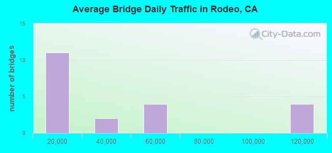
- 724,880Total average daily traffic
- 41,067Total average daily truck traffic
- National Bridge Inventory (NBI) Registered Bridges for Rodeo
- No street view available for this location
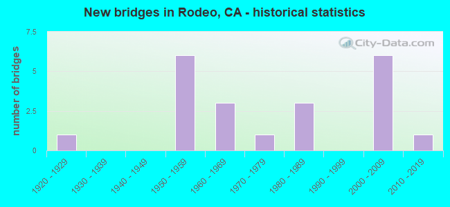
- New bridges - historical statistics
- 11920-1929
- 61950-1959
- 31960-1969
- 11970-1979
- 31980-1989
- 62000-2009
- 12010-2019
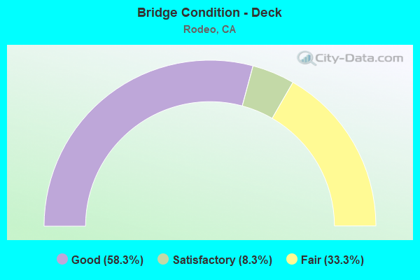
- Bridge Condition - Deck
- 58.3%Good
- 8.3%Satisfactory
- 33.3%Fair
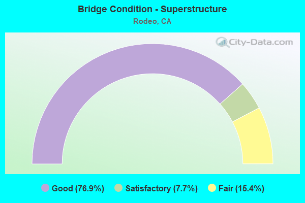
- Bridge Condition - Superstructure
- 76.9%Good
- 7.7%Satisfactory
- 15.4%Fair
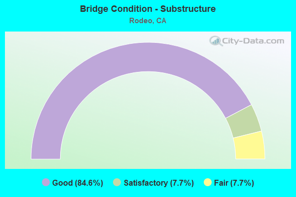
- Bridge Condition - Substructure
- 84.6%Good
- 7.7%Satisfactory
- 7.7%Fair
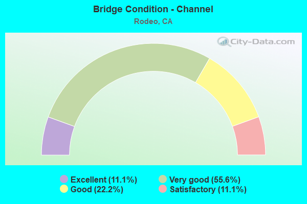
- Bridge Condition - Channel
- 11.1%Excellent
- 55.6%Very good
- 22.2%Good
- 11.1%Satisfactory
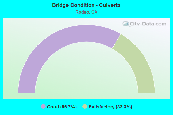
- Bridge Condition - Culverts
- 66.7%Good
- 33.3%Satisfactory
Find on map >> Show street view
Structure Number: 28 0038L, Location: 04-CC-004-R1.90L (Lat: 38.014158, Lng: -122.238650), Route carried "on" structure: State highway 4, Year Built: 2001, Status: Open, Structure Length: 5.00m (16.40ft), Average Daily Traffic: 20,250 (year 2018), Truck Traffic: 8%, Average Future Daily Traffic: 40,584 (year 2042), Design Load: HS 20+Mod, Features Intersected: RODEO CREEK
Minimum Vertical Clearance: 30+ m (98+ ft), Kilometerpoint: 1.900, Lanes on structure: 2, Base Highway Network: Yes (, Subroute: 1), Owner: State Highway Agency, Approaching Roadway Width: 13.7m (44.9ft), Skew: 6 degrees, Material/Design: Concrete continuous, Design/Construction: Slab, Number Of Spans In Main Unit: 5, Length of Maximum Span: 10.0m (32.8ft), Curb-To-Curb Width: 13.7m (44.9ft), Out-to-Out Width: 14.7m (48.2ft)
Condition: Deck: Satisfactory, Superstructure: Satisfactory, Substructure: Good, Channel: Excellent, Operating Rating: 54.1 metric tons, Method Used To Determine Operating Rating: Assigned rating based on Load Factor Design (LFD) reported in metric tons, Inventory Rating: 32.4 metric tons, Method Used To Determine Inventory Rating: Assigned rating based on Load Factor Design (LFD) reported in metric tons, Structural Evaluation: Equal to present minimum criteria, Deck Geometry: Superior to present desirable criteria, Waterway Adequacy: Equal to present desirable criteria, Approach Roadway Alignment: Equal to present desirable criteria, Designated Inspection Frequency: Every 24 months, Inspection Date: May 2020, Deck Structure Type: Concrete Cast-file-Place
Find on map >> Show street view
Structure Number: 28 0154, Location: 04-CC-080-12.13 (Lat: 38.039028, Lng: -122.246539), Route carried "on" structure: Interstate 80, Year Built: 1958, Status: Open, Structure Length: 1.37m (4.49ft), Average Daily Traffic: 115,000 (year 2019), Truck Traffic: 7%, Average Future Daily Traffic: 165,700 (year 2041), Design Load: HS 20, Features Intersected: REFINERY ACCESS RD
Minimum Vertical Clearance: 30+ m (98+ ft), Kilometerpoint: 12.130, Lanes on structure: 8, Base Highway Network: Yes (, Subroute: 1), Owner: State Highway Agency, Approaching Roadway Width: 30.5m (100.1ft), Skew: 30 degrees, Material/Design: Concrete, Design/Construction: Slab, Number Of Spans In Main Unit: 2, Length of Maximum Span: 9.4m (30.8ft), Curb-To-Curb Width: 38.4m (126.0ft), Out-to-Out Width: 39.7m (130.2ft)
Condition: Deck: Good, Superstructure: Good, Substructure: Fair, Operating Rating: 73.5 metric tons, Method Used To Determine Operating Rating: Load Factor (LF), Inventory Rating: 44.4 metric tons, Method Used To Determine Inventory Rating: Load Factor (LF), Structural Evaluation: Somewhat better than minimum adequacy, Deck Geometry: Superior to present desirable criteria, Approach Roadway Alignment: Equal to present desirable criteria, Designated Inspection Frequency: Every 24 months, Inspection Date: July 2021, Deck Structure Type: Concrete Cast-file-Place
Find on map >> Show street view
Structure Number: 28 0155, Location: 04-CC-080-11.69 (Lat: 38.034117, Lng: -122.251392), Route carried "on" structure: Interstate 80, Year Built: 1958, Status: Open, Structure Length: 0.94m (3.08ft), Average Daily Traffic: 115,000 (year 2019), Truck Traffic: 7%, Average Future Daily Traffic: 172,451 (year 2039), Design Load: HS 20, Features Intersected: REFINERY ACCESS RD
Minimum Vertical Clearance: 30+ m (98+ ft), Kilometerpoint: 11.690, Lanes on structure: 8, Base Highway Network: Yes (, Subroute: 1), Owner: State Highway Agency, Approaching Roadway Width: 37.8m (124.0ft), Skew: 30 degrees, Material/Design: Concrete, Design/Construction: Slab, Number Of Spans In Main Unit: 1, Length of Maximum Span: 8.7m (28.5ft), Curb-To-Curb Width: 37.8m (124.0ft), Out-to-Out Width: 40.3m (132.2ft)
Condition: Deck: Fair, Superstructure: Fair, Substructure: Good, Operating Rating: 96.6 metric tons, Method Used To Determine Operating Rating: Load Factor (LF), Inventory Rating: 58.0 metric tons, Method Used To Determine Inventory Rating: Load Factor (LF), Structural Evaluation: Somewhat better than minimum adequacy, Deck Geometry: Superior to present desirable criteria, Approach Roadway Alignment: Equal to present desirable criteria, Designated Inspection Frequency: Every 24 months, Inspection Date: July 2021, Deck Structure Type: Concrete Cast-file-Place
Find on map >> Show street view
Structure Number: 28 0193Y, Location: 04-CC-080-10.71 (Lat: 38.022097, Lng: -122.260908), Route carried "on" structure: Ramp Interstate 80, Year Built: 1958, Status: Open, Structure Length: 0.70m (2.30ft), Average Daily Traffic: 2,250 (year 2019), Truck Traffic: 1%, Average Future Daily Traffic: 4,580 (year 2041), Features Intersected: RODEO CREEK
Minimum Vertical Clearance: 30+ m (98+ ft), Kilometerpoint: 10.710, Lanes on structure: 3, Base Highway Network: Yes (, Subroute: 1), Owner: State Highway Agency, Approaching Roadway Width: 16.5m (54.1ft), Skew: 20 degrees, Material/Design: Concrete continuous, Design/Construction: Culvert, Number Of Spans In Main Unit: 2, Length of Maximum Span: 3.0m (9.8ft)
Condition: Channel: Very good, Culverts: Good, Operating Rating: 54.1 metric tons, Method Used To Determine Operating Rating: Field evaluation and documented engineering judgment, Inventory Rating: 32.4 metric tons, Method Used To Determine Inventory Rating: Field evaluation and documented engineering judgment, Structural Evaluation: Better than present minimum criteria, Waterway Adequacy: Better than present minimum criteria, Approach Roadway Alignment: Somewhat better than minimum adequacy, Designated Inspection Frequency: Every 24 months, Inspection Date: July 2021
Find on map >> Show street view
Structure Number: 28 0194, Location: 04-CC-080-10.73 (Lat: 38.023000, Lng: -122.261733), Route carried "on" structure: Interstate 80, Year Built: 1958, Status: Open, Structure Length: 0.70m (2.30ft), Average Daily Traffic: 115,000 (year 2017), Truck Traffic: 7%, Average Future Daily Traffic: 182,754 (year 2041), Features Intersected: RODEO CREEK
Minimum Vertical Clearance: 30+ m (98+ ft), Kilometerpoint: 10.730, Lanes on structure: 7, Base Highway Network: Yes (, Subroute: 1), Owner: State Highway Agency, Approaching Roadway Width: 30.5m (100.1ft), Skew: 31 degrees, Material/Design: Concrete continuous, Design/Construction: Culvert, Number Of Spans In Main Unit: 2, Length of Maximum Span: 3.0m (9.8ft)
Condition: Channel: Very good, Culverts: Good, Structural Evaluation: Better than present minimum criteria, Waterway Adequacy: Better than present minimum criteria, Approach Roadway Alignment: Equal to present desirable criteria, Designated Inspection Frequency: Every 24 months, Inspection Date: July 2021
Find on map >> Show street view
Structure Number: 28 0213, Location: 04-CC-004-R4.89 (Lat: 38.015775, Lng: -122.190450), Route carried "on" structure: County highway , Year Built: 1967, Status: Open, Structure Length: 6.80m (22.31ft), Average Daily Traffic: 8,100 (year 2018), Truck Traffic: 1%, Average Future Daily Traffic: 11,141 (year 2042), Design Load: HS 20, Features Intersected: STATE ROUTE 4, Facility Carried by Structure: CUMMINGS SKYWAY
Minimum Vertical Clearance: 30+ m (98+ ft), Kilometerpoint: 0.000, Lanes on structure: 2, Lanes under structure: 5, Owner: State Highway Agency, Approaching Roadway Width: 12.5m (41.0ft), Skew: 2 degrees, Material/Design: Concrete continuous, Design/Construction: Box Beam or Girders - Multiple, Number Of Spans In Main Unit: 3, Length of Maximum Span: 27.1m (88.9ft), Curb or Sidewalk Widths: Left: 0.0m, Right: 1.5m (4.9ft), Curb-To-Curb Width: 7.3m (24.0ft), Out-to-Out Width: 9.4m (30.8ft)
Condition: Deck: Good, Superstructure: Good, Substructure: Good, Operating Rating: 35.0 metric tons, Method Used To Determine Operating Rating: Load and Resistance Factor Rating (LRFR) rating reported by rating factor(RF) method using HL-93 loadings, Inventory Rating: 26.9 metric tons, Method Used To Determine Inventory Rating: Load and Resistance Factor Rating (LRFR) rating reported by rating factor(RF) method using HL-93 loadings, Structural Evaluation: Equal to present minimum criteria, Deck Geometry: High priority of replacement, Underclear: Somewhat better than minimum adequacy, Approach Roadway Alignment: Equal to present minimum criteria, Designated Inspection Frequency: Every 24 months, Inspection Date: May 2020, Deck Structure Type: Concrete Cast-file-Place
Find on map >> Show street view
Structure Number: 28 0359, Location: 04-CC-004-R1.70 (Lat: 38.015414, Lng: -122.244883), Route carried "on" structure: County highway , Year Built: 2001, Status: Open, Structure Length: 5.85m (19.19ft), Average Daily Traffic: 35,000 (year 2018), Truck Traffic: 7%, Average Future Daily Traffic: 43,822 (year 2042), Design Load: HS 20+Mod, Features Intersected: STATE ROUTE 4, Facility Carried by Structure: CLAEYS LANE
Minimum Vertical Clearance: 30+ m (98+ ft), Kilometerpoint: 0.000, Lanes on structure: 2, Lanes under structure: 5, Owner: State Highway Agency, Approaching Roadway Width: 9.6m (31.5ft), Material/Design: Prestressed concrete continuous, Design/Construction: Box Beam or Girders - Multiple, Number Of Spans In Main Unit: 2, Length of Maximum Span: 31.0m (101.7ft), Curb-To-Curb Width: 9.6m (31.5ft), Out-to-Out Width: 10.7m (35.1ft)
Condition: Deck: Good, Superstructure: Good, Substructure: Good, Operating Rating: 54.1 metric tons, Method Used To Determine Operating Rating: Assigned rating based on Load Factor Design (LFD) reported in metric tons, Inventory Rating: 32.4 metric tons, Method Used To Determine Inventory Rating: Assigned rating based on Load Factor Design (LFD) reported in metric tons, Structural Evaluation: Better than present minimum criteria, Deck Geometry: High priority of corrective action, Underclear: Somewhat better than minimum adequacy, Approach Roadway Alignment: Equal to present desirable criteria, Designated Inspection Frequency: Every 24 months, Inspection Date: May 2020, Deck Structure Type: Concrete Cast-file-Place
Find on map >> Show street view
Structure Number: 28 0370L, Location: 04-CC-004-R2.70L (Lat: 38.010167, Lng: -122.228517), Route carried "on" structure: State highway 4, Year Built: 2001, Status: Open, Structure Length: 3.35m (10.99ft), Average Daily Traffic: 40,500 (year 2018), Truck Traffic: 8%, Average Future Daily Traffic: 81,169 (year 2042), Design Load: HS 20+Mod, Features Intersected: FRANKLIN CANYON RD
Minimum Vertical Clearance: 30+ m (98+ ft), Kilometerpoint: 2.700, Lanes on structure: 2, Lanes under structure: 2, Base Highway Network: Yes (, Subroute: 1), Owner: State Highway Agency, Approaching Roadway Width: 11.7m (38.4ft), Material/Design: Prestressed concrete, Design/Construction: Box Beam or Girders - Multiple, Number Of Spans In Main Unit: 1, Length of Maximum Span: 33.5m (109.9ft), Curb-To-Curb Width: 11.7m (38.4ft), Out-to-Out Width: 12.7m (41.7ft)
Condition: Deck: Good, Superstructure: Good, Substructure: Good, Operating Rating: 54.1 metric tons, Method Used To Determine Operating Rating: Assigned rating based on Load Factor Design (LFD) reported in metric tons, Inventory Rating: 32.4 metric tons, Method Used To Determine Inventory Rating: Assigned rating based on Load Factor Design (LFD) reported in metric tons, Structural Evaluation: Better than present minimum criteria, Deck Geometry: Better than present minimum criteria, Underclear: High priority of corrective action, Approach Roadway Alignment: Equal to present desirable criteria, Designated Inspection Frequency: Every 24 months, Inspection Date: May 2020, Deck Structure Type: Concrete Cast-file-Place
Find on map >> Show street view
Structure Number: 28 0387, Location: 04-CC-080-11.34 (Lat: 38.030186, Lng: -122.255675), Route carried "on" structure: City street , Year Built: 2006, Status: Open, Structure Length: 5.80m (19.03ft), Average Daily Traffic: 900 (year 2019), Truck Traffic: 3%, Average Future Daily Traffic: 1,388 (year 2042), Design Load: HS 20+Mod, Features Intersected: INTERSTATE 80, Facility Carried by Structure: CALIFORNIA STREET
Minimum Vertical Clearance: 30+ m (98+ ft), Kilometerpoint: 0.000, Lanes on structure: 2, Lanes under structure: 6, Owner: State Highway Agency, Approaching Roadway Width: 10.3m (33.8ft), Skew: 2 degrees, Material/Design: Prestressed concrete continuous, Design/Construction: Box Beam or Girders - Multiple, Number Of Spans In Main Unit: 2, Length of Maximum Span: 29.0m (95.1ft), Curb or Sidewalk Widths: Left: 1.5m (4.9ft), Right: 0.0m, Curb-To-Curb Width: 10.2m (33.5ft), Out-to-Out Width: 12.4m (40.7ft)
Condition: Deck: Fair, Superstructure: Good, Substructure: Good, Operating Rating: 54.1 metric tons, Method Used To Determine Operating Rating: Assigned rating based on Load Factor Design (LFD) reported in metric tons, Inventory Rating: 32.4 metric tons, Method Used To Determine Inventory Rating: Assigned rating based on Load Factor Design (LFD) reported in metric tons, Structural Evaluation: Better than present minimum criteria, Deck Geometry: Equal to present minimum criteria, Underclear: High priority of corrective action, Approach Roadway Alignment: Equal to present desirable criteria, Designated Inspection Frequency: Every 24 months, Inspection Date: July 2021, Deck Structure Type: Concrete Cast-file-Place
Find on map >> Show street view
Structure Number: 28C0169, Location: 0.1 MI E PARKER AVE (Lat: 38.033078, Lng: -122.265797), Route carried "on" structure: County highway , Year Built: 1986, Status: Open, Structure Length: 2.45m (8.04ft), Average Daily Traffic: 4,279 (year 2013), Truck Traffic: 2%, Average Future Daily Traffic: 7,040 (year 2037), Design Load: HS 20+Mod, Features Intersected: RODEO CREEK, Facility Carried by Structure: FOURTH ST
Minimum Vertical Clearance: 30+ m (98+ ft), Kilometerpoint: 0.000, Lanes on structure: 2, Owner: County Highway Agency, Approaching Roadway Width: 11.0m (36.1ft), Material/Design: Concrete continuous, Design/Construction: Slab, Number Of Spans In Main Unit: 3, Length of Maximum Span: 7.9m (25.9ft), Curb or Sidewalk Widths: Left: 1.5m (4.9ft), Right: 1.5m (4.9ft), Curb-To-Curb Width: 12.2m (40.0ft), Out-to-Out Width: 15.8m (51.8ft)
Condition: Deck: Good, Superstructure: Good, Substructure: Good, Channel: Good, Operating Rating: 36.9 metric tons, Method Used To Determine Operating Rating: Load and Resistance Factor Rating (LRFR) rating reported by rating factor(RF) method using HL-93 loadings, Inventory Rating: 28.5 metric tons, Method Used To Determine Inventory Rating: Load and Resistance Factor Rating (LRFR) rating reported by rating factor(RF) method using HL-93 loadings, Structural Evaluation: Better than present minimum criteria, Deck Geometry: Equal to present minimum criteria, Waterway Adequacy: Better than present minimum criteria, Approach Roadway Alignment: Better than present minimum criteria, Designated Inspection Frequency: Every 24 months, Inspection Date: September 2020, Deck Structure Type: Concrete Cast-file-Place, Wearing Surface/Protective System: Wearing Surface: Bituminous
Find on map >> Show street view
Structure Number: 28C0272, Location: AT PARKER STREET (Lat: 38.038411, Lng: -122.267269), Route carried "on" structure: City street , Year Built: 2015, Status: Open, Structure Length: 1.91m (6.27ft), Average Daily Traffic: 3,294 (year 2015), Truck Traffic: 7%, Average Future Daily Traffic: 8,666 (year 2037), Design Load: HL 93, Features Intersected: RODEO CREEK, Facility Carried by Structure: SAN PABLO AVE
Minimum Vertical Clearance: 30+ m (98+ ft), Kilometerpoint: 0.000, Lanes on structure: 2, Owner: County Highway Agency, Approaching Roadway Width: 11.0m (36.1ft), Skew: 20 degrees, Material/Design: Prestressed concrete, Design/Construction: Slab, Number Of Spans In Main Unit: 1, Length of Maximum Span: 18.1m (59.4ft), Curb or Sidewalk Widths: Left: 1.5m (4.9ft), Right: 1.5m (4.9ft), Curb-To-Curb Width: 11.0m (36.1ft), Out-to-Out Width: 19.5m (64.0ft)
Condition: Deck: Good, Superstructure: Good, Substructure: Good, Channel: Very good, Operating Rating: 42.1 metric tons, Method Used To Determine Operating Rating: Assigned ratings based on Load and Resistance Factor Design (LRFD) reported by rating factor (RF) using HL93 loadings, Inventory Rating: 32.4 metric tons, Method Used To Determine Inventory Rating: Assigned ratings based on Load and Resistance Factor Design (LRFD) reported by rating factor (RF) using HL93 loadings, Structural Evaluation: Better than present minimum criteria, Deck Geometry: Somewhat better than minimum adequacy, Waterway Adequacy: Equal to present minimum criteria, Approach Roadway Alignment: Equal to present desirable criteria, Designated Inspection Frequency: Every 48 months, Inspection Date: September 2020, Deck Structure Type: Concrete Cast-file-Place, Wearing Surface/Protective System: Wearing Surface: Integral Concrete
Find on map >> Show street view
Structure Number: 28C0377, Location: 0.04 MI W VAQUEROS AVE (Lat: 38.024583, Lng: -122.263156), Route carried "on" structure: County highway , Year Built: 1959, Status: Open, Structure Length: 2.07m (6.79ft), Average Daily Traffic: 1,237 (year 2013), Truck Traffic: 2%, Average Future Daily Traffic: 1,502 (year 2037), Features Intersected: RODEO CREEK, Facility Carried by Structure: HAWTHORNE DR
Minimum Vertical Clearance: 30+ m (98+ ft), Kilometerpoint: 0.000, Lanes on structure: 2, Owner: County Highway Agency, Approaching Roadway Width: 11.0m (36.1ft), Material/Design: Concrete continuous, Design/Construction: Slab, Number Of Spans In Main Unit: 3, Length of Maximum Span: 6.7m (22.0ft), Curb or Sidewalk Widths: Left: 1.3m (4.3ft), Right: 1.3m (4.3ft), Curb-To-Curb Width: 11.0m (36.1ft), Out-to-Out Width: 14.0m (45.9ft)
Condition: Deck: Fair, Superstructure: Fair, Substructure: Good, Channel: Satisfactory, Operating Rating: 40.5 metric tons, Method Used To Determine Operating Rating: Field evaluation and documented engineering judgment, Inventory Rating: 24.3 metric tons, Method Used To Determine Inventory Rating: Field evaluation and documented engineering judgment, Structural Evaluation: Somewhat better than minimum adequacy, Deck Geometry: Equal to present minimum criteria, Waterway Adequacy: Better than present minimum criteria, Approach Roadway Alignment: Better than present minimum criteria, Designated Inspection Frequency: Every 24 months, Inspection Date: September 2020, Deck Structure Type: Concrete Cast-file-Place, Wearing Surface/Protective System: Wearing Surface: Bituminous
Find on map >> Show street view
Structure Number: 28C0378, Location: JUST E RAILROAD AVE (Lat: 38.035281, Lng: -122.266281), Route carried "on" structure: County highway , Year Built: 1965, Status: Open, Structure Length: 0.82m (2.69ft), Average Daily Traffic: 725 (year 2013), Truck Traffic: 2%, Average Future Daily Traffic: 1,394 (year 2037), Features Intersected: RODEO CREEK, Facility Carried by Structure: THIRD ST
Minimum Vertical Clearance: 30+ m (98+ ft), Kilometerpoint: 0.000, Lanes on structure: 2, Owner: County Highway Agency, Approaching Roadway Width: 12.2m (40.0ft), Skew: 1 degrees, Material/Design: Concrete, Design/Construction: Slab, Number Of Spans In Main Unit: 1, Length of Maximum Span: 7.6m (24.9ft), Curb or Sidewalk Widths: Left: 1.8m (5.9ft), Right: 1.8m (5.9ft), Curb-To-Curb Width: 12.2m (40.0ft), Out-to-Out Width: 15.8m (51.8ft)
Condition: Deck: Good, Superstructure: Good, Substructure: Good, Channel: Very good, Operating Rating: 39.2 metric tons, Method Used To Determine Operating Rating: Load and Resistance Factor Rating (LRFR) rating reported by rating factor(RF) method using HL-93 loadings, Inventory Rating: 30.5 metric tons, Method Used To Determine Inventory Rating: Load and Resistance Factor Rating (LRFR) rating reported by rating factor(RF) method using HL-93 loadings, Structural Evaluation: Better than present minimum criteria, Deck Geometry: Equal to present desirable criteria, Waterway Adequacy: Equal to present desirable criteria, Approach Roadway Alignment: Equal to present minimum criteria, Designated Inspection Frequency: Every 24 months, Inspection Date: September 2020, Deck Structure Type: Concrete Cast-file-Place, Wearing Surface/Protective System: Wearing Surface: Bituminous
Find on map >> Show street view
Structure Number: 28C0379, Location: AT SAN PABLO AVE (Lat: 38.037639, Lng: -122.271081), Route carried "on" structure: County highway , Year Built: 1958, Year Reconstructed: 2002, Status: Open, Structure Length: 3.73m (12.24ft), Average Daily Traffic: 1,518 (year 2013), Truck Traffic: 4%, Average Future Daily Traffic: 2,144 (year 2037), Design Load: H 15, Features Intersected: UP RR, BNSF RY, & AMTRAK, Facility Carried by Structure: PACIFIC AVE
Minimum Vertical Clearance: 30+ m (98+ ft), Kilometerpoint: 0.000, Lanes on structure: 2, Owner: County Highway Agency, Approaching Roadway Width: 7.3m (24.0ft), Material/Design: Steel, Design/Construction: Stringer/Multi-beam, Number Of Spans In Main Unit: 3, Length of Maximum Span: 15.2m (49.9ft), Curb-To-Curb Width: 7.8m (25.6ft), Out-to-Out Width: 8.8m (28.9ft)
Condition: Deck: Fair, Superstructure: Good, Substructure: Satisfactory, Operating Rating: 40.8 metric tons, Method Used To Determine Operating Rating: Load Factor (LF), Inventory Rating: 23.0 metric tons, Method Used To Determine Inventory Rating: Load Factor (LF), Structural Evaluation: Equal to present minimum criteria, Deck Geometry: Meets minimum limits, Underclear: Meets minimum limits, Approach Roadway Alignment: Equal to present minimum criteria, Designated Inspection Frequency: Every 24 months, Other Special Inspection Frequency: Every 48 months, Inspection Date: September 2020, Other Special Inspection Date: March 2021, Deck Structure Type: Concrete Cast-file-Place
Find on map >> Show street view
Structure Number: 28C0437, Location: 0.1 MI E WILLOW AVE (Lat: 38.018344, Lng: -122.256619), Route carried "on" structure: County highway , Year Built: 1974, Status: Open, Structure Length: 0.73m (2.40ft), Average Daily Traffic: 8,599 (year 2013), Truck Traffic: 2%, Average Future Daily Traffic: 18,363 (year 2037), Features Intersected: RODEO CREEK, Facility Carried by Structure: VIEWPOINTE BLVD
Minimum Vertical Clearance: 30+ m (98+ ft), Kilometerpoint: 0.000, Lanes on structure: 4, Owner: County Highway Agency, Approaching Roadway Width: 24.4m (80.1ft), Skew: 22 degrees, Material/Design: Steel, Design/Construction: Arch - Deck, Number Of Spans In Main Unit: 1, Length of Maximum Span: 7.3m (24.0ft)
Condition: Superstructure: Good, Substructure: Good, Channel: Good, Operating Rating: 54.1 metric tons, Method Used To Determine Operating Rating: Field evaluation and documented engineering judgment, Inventory Rating: 32.4 metric tons, Method Used To Determine Inventory Rating: Field evaluation and documented engineering judgment, Structural Evaluation: Better than present minimum criteria, Waterway Adequacy: Equal to present desirable criteria, Approach Roadway Alignment: Better than present minimum criteria, Designated Inspection Frequency: Every 24 months, Inspection Date: September 2020
Find on map >> Show street view
Structure Number: 28C0458, Location: AT VAQUEROS AVE (Lat: 38.028347, Lng: -122.264631), Route carried "on" structure: County highway , Year Built: 1982, Status: Open, Structure Length: 1.19m (3.90ft), Average Daily Traffic: 1,840 (year 2013), Truck Traffic: 3%, Average Future Daily Traffic: 1,502 (year 2036), Features Intersected: RODEO CREEK, Facility Carried by Structure: 7TH ST
Minimum Vertical Clearance: 30+ m (98+ ft), Kilometerpoint: 0.000, Lanes on structure: 2, Owner: County Highway Agency, Approaching Roadway Width: 10.7m (35.1ft), Skew: 1 degrees, Material/Design: Concrete continuous, Design/Construction: Culvert, Number Of Spans In Main Unit: 3, Length of Maximum Span: 3.7m (12.1ft), Curb or Sidewalk Widths: Left: 2.0m (6.6ft), Right: 2.4m (7.9ft), Curb-To-Curb Width: 12.2m (40.0ft), Out-to-Out Width: 17.2m (56.4ft)
Condition: Channel: Very good, Culverts: Satisfactory, Operating Rating: 54.1 metric tons, Method Used To Determine Operating Rating: Field evaluation and documented engineering judgment, Inventory Rating: 32.4 metric tons, Method Used To Determine Inventory Rating: Field evaluation and documented engineering judgment, Structural Evaluation: Equal to present minimum criteria, Deck Geometry: Better than present minimum criteria, Waterway Adequacy: Equal to present desirable criteria, Approach Roadway Alignment: Equal to present minimum criteria, Designated Inspection Frequency: Every 48 months, Inspection Date: September 2018, Deck Structure Type: Concrete Cast-file-Place, Wearing Surface/Protective System: Wearing Surface: Bituminous
Find on map >> Show street view
Structure Number: 28 0213, Location: 04-CC-004-R4.89 (Lat: 38.015775, Lng: -122.190450), Route carried "under" structure: State highway 4, Year Built: 1967, Structure Length: 0. m, Average Daily Traffic: 43,500 (year 2018), Features Intersected: STATE ROUTE 4, Facility Carried by Structure: CUMMINGS SKYWAY
Minimum Vertical Clearance: 4.54m (14.90ft), Kilometerpoint: 4.890, Lanes on structure: 2, Lanes under structure: 5, Material/Design: Concrete continuous, Design/Construction: Box Beam or Girders - Multiple, Length of Maximum Span: 27.1m (88.9ft)
Find on map >> Show street view
Structure Number: 28 0284, Location: 04-CC-004-R1.00 (Lat: 38.014758, Lng: -122.251350), Route carried "under" structure: State highway 4, Year Built: 1985, Structure Length: 0. m, Average Daily Traffic: 42,500 (year 2018), Features Intersected: STATE ROUTE 4, Facility Carried by Structure: BNSF RY
Minimum Vertical Clearance: 9.07m (29.76ft), Kilometerpoint: 1.000, Lanes under structure: 4, Material/Design: Prestressed concrete continuous, Design/Construction: Box Beam or Girders - Multiple, Length of Maximum Span: 41.1m (134.8ft)
Find on map >> Show street view
Structure Number: 28 0359, Location: 04-CC-004-R1.70 (Lat: 38.015414, Lng: -122.244883), Route carried "under" structure: State highway 4, Year Built: 2001, Structure Length: 0. m, Average Daily Traffic: 42,500 (year 2018), Features Intersected: STATE ROUTE 4, Facility Carried by Structure: CLAEYS LANE
Minimum Vertical Clearance: 6.05m (19.85ft), Kilometerpoint: 1.700, Lanes on structure: 2, Lanes under structure: 5, Material/Design: Prestressed concrete continuous, Design/Construction: Box Beam or Girders - Multiple, Length of Maximum Span: 31.0m (101.7ft)
Find on map >> Show street view
Structure Number: 28 0387, Location: 04-CC-080-11.34 (Lat: 38.030186, Lng: -122.255675), Route carried "under" structure: Interstate 80, Year Built: 2006, Structure Length: 0. m, Average Daily Traffic: 115,000 (year 2019), Truck Traffic: 7%, Features Intersected: INTERSTATE 80, Facility Carried by Structure: CALIFORNIA STREET
Minimum Vertical Clearance: 5.28m (17.32ft), Kilometerpoint: 11.340, Lanes on structure: 2, Lanes under structure: 6, Material/Design: Prestressed concrete continuous, Design/Construction: Box Beam or Girders - Multiple, Length of Maximum Span: 29.0m (95.1ft)
Find on map >> Show street view
Structure Number: 28C0139, Location: 2 MI SW CARQUINEZ BR (Lat: 38.049472, Lng: -122.256011), Route carried "under" structure: County highway , Year Built: 1925, Structure Length: 0. m, Average Daily Traffic: 7,888 (year 2009), Truck Traffic: 10%, Features Intersected: SAN PABLO AVE, Facility Carried by Structure: PIPELINES
Minimum Vertical Clearance: 5.18m (16.99ft), Kilometerpoint: 0.000, Lanes under structure: 4, Material/Design: Steel, Design/Construction: Stringer/Multi-beam, Length of Maximum Span: 25.0m (82.0ft)