Bridge Statistics for Rockwood, Michigan (MI)
Condition, Traffic, Stress, Structural Evaluation, Project Costs
- National Bridge Inventory (NBI) Statistics
- 22Number of bridges
- 171ft / 52.0mTotal length
- 272,498Total average daily traffic
- 44,696Total average daily truck traffic
- National Bridge Inventory (NBI) Registered Bridges for Rockwood
- No street view available for this location
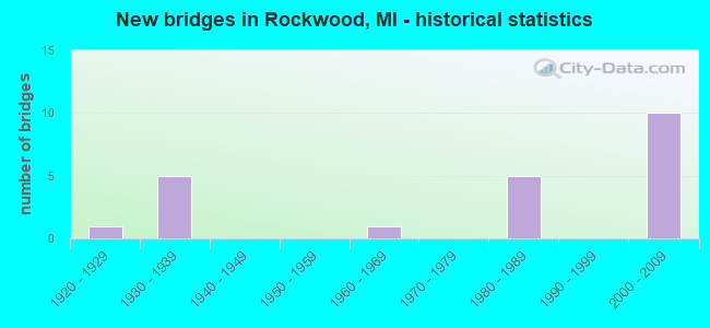
- New bridges - historical statistics
- 11920-1929
- 51930-1939
- 11960-1969
- 51980-1989
- 102000-2009


- Bridge Condition - Deck
- 47.1%Good
- 35.3%Satisfactory
- 5.9%Poor
- 11.8%Serious

- Bridge Condition - Superstructure
- 17.6%Very good
- 41.2%Good
- 17.6%Satisfactory
- 5.9%Fair
- 11.8%Poor
- 5.9%Serious

- Bridge Condition - Substructure
- 23.5%Very good
- 11.8%Good
- 29.4%Satisfactory
- 23.5%Fair
- 11.8%Poor

- Bridge Condition - Channel
- 12.5%Very good
- 25.0%Good
- 43.8%Satisfactory
- 18.8%Fair

- Bridge Condition - Culverts
- 50.0%Very good
- 50.0%Good
Find on map >> Show street view
Structure Number: 1199, Location: 3.5 MI N OF I-94 (Lat: 42.318783, Lng: -85.178675), Route carried "on" structure: State highway 66, Year Built: 1966, Status: Open, Structure Length: 2.62m (8.60ft), Average Daily Traffic: 15,300 (year 2013), Truck Traffic: 2%, Average Future Daily Traffic: 26,074 (year 2018), Design Load: HS 20, Features Intersected: BATTLE CREEK RIVER
Minimum Vertical Clearance: 30.48m (100.00ft), Kilometerpoint: 0.348, Lanes on structure: 5, Base Highway Network: Yes (Inventory Route: 186, Subroute: 3), Owner: State Highway Agency, Approaching Roadway Width: 17.4m (57.1ft), Material/Design: Prestressed concrete, Design/Construction: Stringer/Multi-beam, Number Of Spans In Main Unit: 2, Length of Maximum Span: 13.1m (43.0ft), Curb or Sidewalk Widths: Left: 2.4m (7.9ft), Right: 2.4m (7.9ft), Curb-To-Curb Width: 17.4m (57.1ft), Out-to-Out Width: 22.9m (75.1ft)
Condition: Deck: Satisfactory, Superstructure: Good, Substructure: Fair, Channel: Satisfactory, Operating Rating: 70.3 metric tons, Method Used To Determine Operating Rating: Load Factor (LF) rating reported by rating factor (RF) method using MS18 loading, Inventory Rating: 29.8 metric tons, Method Used To Determine Inventory Rating: Load Factor (LF) rating reported by rating factor (RF) method using MS18 loading, Structural Evaluation: Somewhat better than minimum adequacy, Deck Geometry: High priority of replacement, Waterway Adequacy: Equal to present desirable criteria, Approach Roadway Alignment: Equal to present desirable criteria, Designated Inspection Frequency: Every 24 months, Underwater Inspection Frequency: Every 60 months, Inspection Date: July 2021, Underwater Inspection Date: June 2017, Deck Structure Type: Concrete Cast-file-Place, Wearing Surface/Protective System: Wearing Surface: Monolithic Concrete
Find on map >> Show street view
Structure Number: 7193, Location: IN ROCKWOOD (Lat: 42.067928, Lng: -83.254133), Route carried "on" structure: Interstate 75, Year Built: 2009, Status: Open, Structure Length: 6.10m (20.01ft), Average Daily Traffic: 26,929 (year 2007), Truck Traffic: 21%, Average Future Daily Traffic: 40,250 (year 2028), Design Load: Greater than HL93, Features Intersected: HURON RIVER
Minimum Vertical Clearance: 30+ m (98+ ft), Kilometerpoint: 43.064, Lanes on structure: 3, Base Highway Network: Yes (Inventory Route: 122, Subroute: 10), Owner: State Highway Agency, Approaching Roadway Width: 17.8m (58.4ft), Skew: 31 degrees, Material/Design: Steel continuous, Design/Construction: Stringer/Multi-beam, Number Of Spans In Main Unit: 3, Length of Maximum Span: 27.4m (89.9ft), Curb-To-Curb Width: 17.7m (58.1ft), Out-to-Out Width: 18.7m (61.4ft)
Condition: Deck: Good, Superstructure: Good, Substructure: Good, Channel: Very good, Operating Rating: 72.6 metric tons, Method Used To Determine Operating Rating: Load and Resistance Factor Rating (LRFR) rating reported by rating factor(RF) method using HL-93 loadings, Inventory Rating: 56.1 metric tons, Method Used To Determine Inventory Rating: Load and Resistance Factor Rating (LRFR) rating reported by rating factor(RF) method using HL-93 loadings, Structural Evaluation: Better than present minimum criteria, Deck Geometry: Better than present minimum criteria, Waterway Adequacy: Equal to present minimum criteria, Approach Roadway Alignment: Equal to present desirable criteria, Designated Inspection Frequency: Every 24 months, Inspection Date: August 2021, Deck Structure Type: Concrete Cast-file-Place, Wearing Surface/Protective System: Wearing Surface: Monolithic Concrete, Deck Protection: Epoxy Coated Reinforcing
Find on map >> Show street view
Structure Number: 7279, Location: 1.25 MI SW OF COUNTY LINE (Lat: 42.026894, Lng: -83.225064), Route carried "on" structure: County highway 5885, Year Built: 2006, Status: Open, Structure Length: 1.89m (6.20ft), Average Daily Traffic: 1,768 (year 2017), Truck Traffic: 20%, Average Future Daily Traffic: 2,033 (year 2037), Design Load: HS 20+Mod, Features Intersected: MOUILLEE CREEK, Facility Carried by Structure: US TURNPIKE
Minimum Vertical Clearance: 30.48m (100.00ft), Kilometerpoint: 20.034, Lanes on structure: 2, Base Highway Network: Yes (Inventory Route: 430, Subroute: 55), Owner: County Highway Agency, Approaching Roadway Width: 8.5m (27.9ft), Material/Design: Prestressed concrete, Design/Construction: Box Beam or Girders - Multiple, Number Of Spans In Main Unit: 1, Length of Maximum Span: 18.0m (59.1ft), Curb-To-Curb Width: 12.8m (42.0ft), Out-to-Out Width: 13.5m (44.3ft)
Condition: Deck: Good, Superstructure: Very good, Substructure: Very good, Channel: Very good, Operating Rating: 97.2 metric tons, Method Used To Determine Operating Rating: Load Factor (LF) rating reported by rating factor (RF) method using MS18 loading, Inventory Rating: 64.8 metric tons, Method Used To Determine Inventory Rating: Load Factor (LF) rating reported by rating factor (RF) method using MS18 loading, Structural Evaluation: Equal to present desirable criteria, Deck Geometry: Better than present minimum criteria, Waterway Adequacy: Equal to present minimum criteria, Approach Roadway Alignment: Equal to present desirable criteria, Designated Inspection Frequency: Every 24 months, Inspection Date: June 2020, Deck Structure Type: Concrete Cast-file-Place, Wearing Surface/Protective System: Wearing Surface: Monolithic Concrete, Deck Protection: Epoxy Coated Reinforcing
Find on map >> Show street view
Structure Number: 11631, Location: 0.3 MI N OF N HURON RI DR (Lat: 42.076583, Lng: -83.247106), Route carried "on" structure: Interstate 75, Year Built: 2008, Status: Open, Structure Length: 1.37m (4.49ft), Average Daily Traffic: 31,294 (year 2007), Truck Traffic: 19%, Average Future Daily Traffic: 91,000 (year 2028), Design Load: Greater than HL93, Features Intersected: SILVER CREEK
Minimum Vertical Clearance: 30.48m (100.00ft), Kilometerpoint: 1.114, Lanes on structure: 8, Base Highway Network: Yes (Inventory Route: 159, Subroute: 10), Owner: State Highway Agency, Approaching Roadway Width: 44.1m (144.7ft), Skew: 3 degrees, Material/Design: Concrete, Design/Construction: Culvert, Number Of Spans In Main Unit: 1, Length of Maximum Span: 12.2m (40.0ft), Curb-To-Curb Width: 44.1m (144.7ft), Out-to-Out Width: 77.4m (253.9ft)
Condition: Channel: Good, Culverts: Very good, Operating Rating: 93.6 metric tons, Method Used To Determine Operating Rating: Load Factor (LF) rating reported by rating factor (RF) method using MS18 loading, Inventory Rating: 56.1 metric tons, Method Used To Determine Inventory Rating: Load Factor (LF) rating reported by rating factor (RF) method using MS18 loading, Structural Evaluation: Equal to present desirable criteria, Deck Geometry: Superior to present desirable criteria, Waterway Adequacy: Equal to present minimum criteria, Approach Roadway Alignment: Equal to present minimum criteria, Designated Inspection Frequency: Every 24 months, Inspection Date: July 2020, Deck Structure Type: Concrete Precast Panels, Wearing Surface/Protective System: Wearing Surface: Monolithic Concrete
Find on map >> Show street view
Structure Number: 11642, Location: IN ROCKWOOD (Lat: 42.070194, Lng: -83.252286), Route carried "on" structure: Interstate 75, Year Built: 2008, Status: Open, Structure Length: 4.70m (15.42ft), Average Daily Traffic: 62,588 (year 2007), Truck Traffic: 21%, Average Future Daily Traffic: 40,250 (year 2028), Design Load: Greater than HL93, Features Intersected: NORTH HURON RIVER DRIVE
Minimum Vertical Clearance: 30+ m (98+ ft), Kilometerpoint: 0.285, Lanes on structure: 4, Lanes under structure: 4, Base Highway Network: Yes (Inventory Route: 159, Subroute: 10), Owner: State Highway Agency, Approaching Roadway Width: 21.3m (69.9ft), Skew: 31 degrees, Material/Design: Steel, Design/Construction: Stringer/Multi-beam, Number Of Spans In Main Unit: 3, Length of Maximum Span: 22.5m (73.8ft), Curb-To-Curb Width: 21.3m (69.9ft), Out-to-Out Width: 22.4m (73.5ft)
Condition: Deck: Good, Superstructure: Very good, Substructure: Very good, Operating Rating: 69.7 metric tons, Method Used To Determine Operating Rating: Load and Resistance Factor Rating (LRFR) rating reported by rating factor(RF) method using HL-93 loadings, Inventory Rating: 53.8 metric tons, Method Used To Determine Inventory Rating: Load and Resistance Factor Rating (LRFR) rating reported by rating factor(RF) method using HL-93 loadings, Structural Evaluation: Equal to present desirable criteria, Deck Geometry: Better than present minimum criteria, Underclear: Somewhat better than minimum adequacy, Approach Roadway Alignment: Equal to present desirable criteria, Designated Inspection Frequency: Every 24 months, Inspection Date: July 2020, Deck Structure Type: Concrete Cast-file-Place, Wearing Surface/Protective System: Wearing Surface: Monolithic Concrete, Deck Protection: Epoxy Coated Reinforcing
Find on map >> Show street view
Structure Number: 11643, Location: 0.8 MI N OF MONROE COL (Lat: 42.081078, Lng: -83.243253), Route carried "on" structure: County highway , Year Built: 2008, Status: Open, Structure Length: 10.51m (34.48ft), Average Daily Traffic: 5,328 (year 2007), Average Future Daily Traffic: 1,250 (year 2028), Design Load: HL 93, Features Intersected: I-75 & M-85, Facility Carried by Structure: WOODRUFF RD
Minimum Vertical Clearance: 30.48m (100.00ft), Kilometerpoint: 2.955, Lanes on structure: 2, Lanes under structure: 8, Owner: State Highway Agency, Approaching Roadway Width: 14.0m (45.9ft), Skew: 3 degrees, Material/Design: Steel continuous, Design/Construction: Stringer/Multi-beam, Number Of Spans In Main Unit: 4, Length of Maximum Span: 25.5m (83.7ft), Curb or Sidewalk Widths: Left: 0.0m, Right: 1.6m (5.2ft), Curb-To-Curb Width: 14.0m (45.9ft), Out-to-Out Width: 16.3m (53.5ft)
Condition: Deck: Good, Superstructure: Very good, Substructure: Very good, Operating Rating: 86.5 metric tons, Method Used To Determine Operating Rating: Load and Resistance Factor Rating (LRFR) rating reported by rating factor(RF) method using HL-93 loadings, Inventory Rating: 66.7 metric tons, Method Used To Determine Inventory Rating: Load and Resistance Factor Rating (LRFR) rating reported by rating factor(RF) method using HL-93 loadings, Structural Evaluation: Equal to present desirable criteria, Deck Geometry: Superior to present desirable criteria, Underclear: Somewhat better than minimum adequacy, Approach Roadway Alignment: Equal to present minimum criteria, Designated Inspection Frequency: Every 24 months, Inspection Date: July 2020, Deck Structure Type: Concrete Cast-file-Place, Wearing Surface/Protective System: Wearing Surface: Monolithic Concrete, Deck Protection: Epoxy Coated Reinforcing
Find on map >> Show street view
Structure Number: 11989, Location: ROCKWOOD E/STREICHER (Lat: 42.066897, Lng: -83.234067), Route carried "on" structure: County highway 2057, Year Built: 1981, Status: Open, Structure Length: 0.79m (2.59ft), Average Daily Traffic: 6,080 (year 1996), Truck Traffic: 5%, Average Future Daily Traffic: 5,213 (year 2015), Design Load: HS 25 or greater, Features Intersected: SILVER CREEK, Facility Carried by Structure: HURON RIVER DRIVE
Minimum Vertical Clearance: 30.48m (100.00ft), Kilometerpoint: 6.373, Lanes on structure: 2, Owner: County Highway Agency, Approaching Roadway Width: 11.6m (38.1ft), Skew: 1 degrees, Material/Design: Prestressed concrete, Design/Construction: Box Beam or Girders - Multiple, Number Of Spans In Main Unit: 1, Length of Maximum Span: 6.7m (22.0ft), Curb-To-Curb Width: 14.0m (45.9ft), Out-to-Out Width: 15.2m (49.9ft)
Condition: Deck: Good, Superstructure: Good, Substructure: Satisfactory, Channel: Good, Operating Rating: 42.1 metric tons, Method Used To Determine Operating Rating: Load and Resistance Factor Rating (LRFR) rating reported by rating factor(RF) method using HL-93 loadings, Inventory Rating: 32.7 metric tons, Method Used To Determine Inventory Rating: Load and Resistance Factor Rating (LRFR) rating reported by rating factor(RF) method using HL-93 loadings, Structural Evaluation: Equal to present minimum criteria, Deck Geometry: Superior to present desirable criteria, Waterway Adequacy: Equal to present desirable criteria, Approach Roadway Alignment: Equal to present desirable criteria, Designated Inspection Frequency: Every 24 months, Inspection Date: September 2020, Deck Structure Type: Concrete Cast-file-Place, Wearing Surface/Protective System: Wearing Surface: Monolithic Concrete
Find on map >> Show street view
Structure Number: 1199, Location: ROCKWOOD W/JEFFERSON (Lat: 42.067119, Lng: -83.228792), Route carried "on" structure: County highway 2057, Year Built: 1989, Status: Open, Structure Length: 0.73m (2.40ft), Average Daily Traffic: 6,080 (year 1996), Truck Traffic: 10%, Average Future Daily Traffic: 5,213 (year 2015), Design Load: HS 25 or greater, Features Intersected: SMITH CREEK, Facility Carried by Structure: HURON RIVER DRIVE
Minimum Vertical Clearance: 30.48m (100.00ft), Kilometerpoint: 6.811, Lanes on structure: 2, Owner: County Highway Agency, Approaching Roadway Width: 11.0m (36.1ft), Material/Design: Prestressed concrete, Design/Construction: Box Beam or Girders - Multiple, Number Of Spans In Main Unit: 1, Length of Maximum Span: 6.1m (20.0ft), Curb-To-Curb Width: 13.1m (43.0ft), Out-to-Out Width: 14.2m (46.6ft)
Condition: Deck: Good, Superstructure: Good, Substructure: Good, Channel: Satisfactory, Operating Rating: 42.8 metric tons, Method Used To Determine Operating Rating: Load and Resistance Factor Rating (LRFR) rating reported by rating factor(RF) method using HL-93 loadings, Inventory Rating: 33.0 metric tons, Method Used To Determine Inventory Rating: Load and Resistance Factor Rating (LRFR) rating reported by rating factor(RF) method using HL-93 loadings, Structural Evaluation: Better than present minimum criteria, Deck Geometry: Somewhat better than minimum adequacy, Waterway Adequacy: Equal to present desirable criteria, Approach Roadway Alignment: Equal to present desirable criteria, Designated Inspection Frequency: Every 24 months, Inspection Date: September 2020, Deck Structure Type: Concrete Precast Panels, Wearing Surface/Protective System: Wearing Surface: Integral Concrete, Deck Protection: Epoxy Coated Reinforcing
Find on map >> Show street view
Structure Number: 12183, Location: ROCKWOOD S/HURON RIVER DR (Lat: 42.064272, Lng: -83.253725), Route carried "on" structure: County highway 2057, Year Built: 1981, Status: Open, Structure Length: 5.51m (18.08ft), Average Daily Traffic: 5,161 (year 1996), Truck Traffic: 5%, Average Future Daily Traffic: 4,934 (year 2015), Features Intersected: HURON RIVER, Facility Carried by Structure: FORT STREET
Minimum Vertical Clearance: 30.48m (100.00ft), Kilometerpoint: 0.220, Lanes on structure: 2, Owner: County Highway Agency, Approaching Roadway Width: 15.8m (51.8ft), Skew: 3 degrees, Material/Design: Steel continuous, Design/Construction: Stringer/Multi-beam, Number Of Spans In Main Unit: 3, Length of Maximum Span: 23.1m (75.8ft), Curb or Sidewalk Widths: Left: 0.2m (0.7ft), Right: 0.2m (0.7ft), Curb-To-Curb Width: 15.4m (50.5ft), Out-to-Out Width: 16.6m (54.5ft)
Condition: Deck: Good, Superstructure: Good, Substructure: Satisfactory, Channel: Satisfactory, Operating Rating: 97.2 metric tons, Method Used To Determine Operating Rating: Load Factor (LF) rating reported by rating factor (RF) method using MS18 loading, Inventory Rating: 75.8 metric tons, Method Used To Determine Inventory Rating: Load Factor (LF) rating reported by rating factor (RF) method using MS18 loading, Structural Evaluation: Equal to present minimum criteria, Deck Geometry: Superior to present desirable criteria, Waterway Adequacy: Equal to present desirable criteria, Approach Roadway Alignment: Equal to present desirable criteria, Designated Inspection Frequency: Every 24 months, Inspection Date: June 2021, Deck Structure Type: Concrete Cast-file-Place, Wearing Surface/Protective System: Wearing Surface: Monolithic Concrete, Deck Protection: Epoxy Coated Reinforcing
Find on map >> Show street view
Structure Number: 12196, Location: BROWNSTOWN COUNTY LINE (Lat: 42.042778, Lng: -83.214042), Route carried "on" structure: County highway 2057, Year Built: 1930, Status: Posted for load, Structure Length: 5.03m (16.50ft), Average Daily Traffic: 4,529 (year 1996), Truck Traffic: 7%, Average Future Daily Traffic: 4,482 (year 2015), Design Load: HS 20+Mod, Features Intersected: HURON RIVER, Facility Carried by Structure: JEFFERSON AVENUE
Minimum Vertical Clearance: 30.48m (100.00ft), Kilometerpoint: 0.100, Lanes on structure: 2, Owner: County Highway Agency, Approaching Roadway Width: 11.0m (36.1ft), Material/Design: Steel, Design/Construction: Stringer/Multi-beam, Number Of Spans In Main Unit: 3, Length of Maximum Span: 16.7m (54.8ft), Curb or Sidewalk Widths: Left: 1.0m (3.3ft), Right: 1.0m (3.3ft), Curb-To-Curb Width: 11.0m (36.1ft), Out-to-Out Width: 14.0m (45.9ft)
Condition: Deck: Serious, Superstructure: Poor, Substructure: Poor, Channel: Satisfactory, Operating Rating: 27.9 metric tons, Method Used To Determine Operating Rating: Load Factor (LF) rating reported by rating factor (RF) method using MS18 loading, Inventory Rating: 16.5 metric tons, Method Used To Determine Inventory Rating: Load Factor (LF) rating reported by rating factor (RF) method using MS18 loading, Structural Evaluation: Meets minimum limits, Deck Geometry: Somewhat better than minimum adequacy, Waterway Adequacy: Equal to present desirable criteria, Approach Roadway Alignment: Equal to present desirable criteria, Bridge Posting: Required (Relationship of Operating Rating to Maximum Legal Load: > 39.9% below), Designated Inspection Frequency: Every 12 months, Underwater Inspection Frequency: Every 60 months, Inspection Date: April 2021, Underwater Inspection Date: November 2018, Deck Structure Type: Concrete Cast-file-Place, Wearing Surface/Protective System: Wearing Surface: Integral Concrete
Find on map >> Show street view
Structure Number: 12197, Location: BROWNSTOWN S/CAMPAU (Lat: 42.047842, Lng: -83.211372), Route carried "on" structure: County highway 2057, Year Built: 1927, Status: Open, Structure Length: 2.19m (7.19ft), Average Daily Traffic: 4,529 (year 1996), Truck Traffic: 7%, Average Future Daily Traffic: 4,482 (year 2015), Design Load: HS 20+Mod, Features Intersected: SILVER CREEK, Facility Carried by Structure: JEFFERSON AVENUE
Minimum Vertical Clearance: 30.48m (100.00ft), Kilometerpoint: 0.758, Lanes on structure: 2, Owner: County Highway Agency, Approaching Roadway Width: 11.0m (36.1ft), Skew: 3 degrees, Material/Design: Steel, Design/Construction: Stringer/Multi-beam, Number Of Spans In Main Unit: 2, Length of Maximum Span: 10.0m (32.8ft), Curb or Sidewalk Widths: Left: 0.5m (1.6ft), Right: 0.5m (1.6ft), Curb-To-Curb Width: 11.0m (36.1ft), Out-to-Out Width: 13.9m (45.6ft)
Condition: Deck: Satisfactory, Superstructure: Satisfactory, Substructure: Fair, Channel: Satisfactory, Operating Rating: 65.4 metric tons, Method Used To Determine Operating Rating: Load Factor (LF) rating reported by rating factor (RF) method using MS18 loading, Inventory Rating: 39.2 metric tons, Method Used To Determine Inventory Rating: Load Factor (LF) rating reported by rating factor (RF) method using MS18 loading, Structural Evaluation: Somewhat better than minimum adequacy, Deck Geometry: Somewhat better than minimum adequacy, Waterway Adequacy: Equal to present desirable criteria, Approach Roadway Alignment: Equal to present desirable criteria, Designated Inspection Frequency: Every 24 months, Underwater Inspection Frequency: Every 24 months, Inspection Date: September 2020, Underwater Inspection Date: November 2020, Deck Structure Type: Concrete Cast-file-Place, Wearing Surface/Protective System: Wearing Surface: Integral Concrete
Find on map >> Show street view
Structure Number: 12248, Location: BRNTWN/RKWDE/FORT (Lat: 42.081183, Lng: -83.236872), Route carried "on" structure: County highway , Year Built: 1981, Status: Open, Structure Length: 0.76m (2.49ft), Average Daily Traffic: 583 (year 1996), Truck Traffic: 1%, Average Future Daily Traffic: 787 (year 2015), Design Load: H 20, Features Intersected: SMITH CREEK, Facility Carried by Structure: WOODRUFF ROAD
Minimum Vertical Clearance: 30.48m (100.00ft), Kilometerpoint: 3.505, Lanes on structure: 2, Owner: County Highway Agency, Approaching Roadway Width: 8.5m (27.9ft), Material/Design: Prestressed concrete, Design/Construction: Box Beam or Girders - Multiple, Number Of Spans In Main Unit: 1, Length of Maximum Span: 6.4m (21.0ft), Curb or Sidewalk Widths: Left: 0.3m (1.0ft), Right: 0.3m (1.0ft), Curb-To-Curb Width: 13.1m (43.0ft), Out-to-Out Width: 14.5m (47.6ft)
Condition: Deck: Satisfactory, Superstructure: Good, Substructure: Satisfactory, Channel: Good, Operating Rating: 84.6 metric tons, Method Used To Determine Operating Rating: Load Factor (LF) rating reported by rating factor (RF) method using MS18 loading, Inventory Rating: 50.9 metric tons, Method Used To Determine Inventory Rating: Load Factor (LF) rating reported by rating factor (RF) method using MS18 loading, Structural Evaluation: Equal to present minimum criteria, Deck Geometry: Superior to present desirable criteria, Waterway Adequacy: Equal to present desirable criteria, Approach Roadway Alignment: Equal to present desirable criteria, Designated Inspection Frequency: Every 24 months, Inspection Date: September 2020, Deck Structure Type: Concrete Precast Panels, Wearing Surface/Protective System: Wearing Surface: Integral Concrete, Deck Protection: Epoxy Coated Reinforcing
Find on map >> Show street view
Structure Number: 1225, Location: BRNTWNW/JEFFERSON (Lat: 42.060803, Lng: -83.224458), Route carried "on" structure: County highway , Year Built: 1937, Year Reconstructed: 1975, Status: Open, Structure Length: 0.82m (2.69ft), Average Daily Traffic: 253 (year 1996), Truck Traffic: 2%, Average Future Daily Traffic: 359 (year 2015), Design Load: HS 20, Features Intersected: SMITH CREEK, Facility Carried by Structure: STREICHER ROAD
Minimum Vertical Clearance: 30.48m (100.00ft), Kilometerpoint: 1.176, Lanes on structure: 2, Owner: County Highway Agency, Approaching Roadway Width: 7.3m (24.0ft), Material/Design: Prestressed concrete, Design/Construction: Tee Beam, Number Of Spans In Main Unit: 1, Length of Maximum Span: 7.3m (24.0ft), Curb or Sidewalk Widths: Left: 0.5m (1.6ft), Right: 0.5m (1.6ft), Curb-To-Curb Width: 7.2m (23.6ft), Out-to-Out Width: 8.2m (26.9ft)
Condition: Deck: Satisfactory, Superstructure: Satisfactory, Substructure: Poor, Channel: Fair, Operating Rating: 62.2 metric tons, Method Used To Determine Operating Rating: Load Factor (LF) rating reported by rating factor (RF) method using MS18 loading, Inventory Rating: 37.3 metric tons, Method Used To Determine Inventory Rating: Load Factor (LF) rating reported by rating factor (RF) method using MS18 loading, Structural Evaluation: Meets minimum limits, Deck Geometry: Meets minimum limits, Waterway Adequacy: Equal to present desirable criteria, Approach Roadway Alignment: Equal to present minimum criteria, Designated Inspection Frequency: Every 12 months, Inspection Date: September 2021, Deck Structure Type: Concrete Precast Panels, Wearing Surface/Protective System: Wearing Surface: Integral Concrete
Find on map >> Show street view
Structure Number: 12251, Location: BRNTWNW/JEFFERSON (Lat: 42.042931, Lng: -83.214161), Route carried "on" structure: County highway , Year Built: 1930, Status: Open, Structure Length: 1.37m (4.49ft), Average Daily Traffic: 250 (year 1987), Truck Traffic: 1%, Average Future Daily Traffic: 288 (year 2015), Design Load: H 20, Features Intersected: SILVER CREEK, Facility Carried by Structure: HARBIN DRIVE
Minimum Vertical Clearance: 30.48m (100.00ft), Kilometerpoint: 0.027, Lanes on structure: 2, Owner: County Highway Agency, Approaching Roadway Width: 7.6m (24.9ft), Material/Design: Concrete, Design/Construction: Arch - Deck, Number Of Spans In Main Unit: 1, Length of Maximum Span: 12.2m (40.0ft), Curb or Sidewalk Widths: Left: 0.3m (1.0ft), Right: 0.3m (1.0ft), Curb-To-Curb Width: 8.2m (26.9ft), Out-to-Out Width: 8.2m (26.9ft)
Condition: Deck: Satisfactory, Superstructure: Fair, Substructure: Satisfactory, Channel: Satisfactory, Operating Rating: 32.7 metric tons, Method Used To Determine Operating Rating: Field evaluation and documented engineering judgment, Inventory Rating: 19.6 metric tons, Method Used To Determine Inventory Rating: Field evaluation and documented engineering judgment, Structural Evaluation: Somewhat better than minimum adequacy, Deck Geometry: Somewhat better than minimum adequacy, Waterway Adequacy: Meets minimum limits, Approach Roadway Alignment: Equal to present desirable criteria, Designated Inspection Frequency: Every 24 months, Underwater Inspection Frequency: Every 60 months, Inspection Date: September 2020, Underwater Inspection Date: November 2018, Wearing Surface/Protective System: Wearing Surface: Gravel
Find on map >> Show street view
Structure Number: 12252, Location: BRNTWNW/JEFFERSON (Lat: 42.047303, Lng: -83.211703), Route carried "on" structure: County highway , Year Built: 1930, Status: Posted for load, Structure Length: 0.73m (2.40ft), Average Daily Traffic: 100 (year 1987), Average Future Daily Traffic: 115 (year 2015), Design Load: H 15, Features Intersected: SILVER CREEK, Facility Carried by Structure: LELAND DRIVE
Minimum Vertical Clearance: 30.48m (100.00ft), Kilometerpoint: 0.148, Lanes on structure: 2, Owner: County Highway Agency, Approaching Roadway Width: 6.7m (22.0ft), Material/Design: Concrete, Design/Construction: Slab, Number Of Spans In Main Unit: 1, Length of Maximum Span: 6.4m (21.0ft), Curb-To-Curb Width: 6.4m (21.0ft), Out-to-Out Width: 7.0m (23.0ft)
Condition: Deck: Serious, Superstructure: Serious, Substructure: Fair, Channel: Fair, Operating Rating: 40.7 metric tons, Method Used To Determine Operating Rating: Field evaluation and documented engineering judgment, Inventory Rating: 24.4 metric tons, Method Used To Determine Inventory Rating: Field evaluation and documented engineering judgment, Structural Evaluation: High priority of corrective action, Deck Geometry: Somewhat better than minimum adequacy, Waterway Adequacy: Equal to present desirable criteria, Approach Roadway Alignment: Equal to present minimum criteria, Bridge Posting: Required (Relationship of Operating Rating to Maximum Legal Load: 0.1 - 9.9% below), Designated Inspection Frequency: Every 12 months, Inspection Date: May 2021, Deck Structure Type: Concrete Cast-file-Place, Wearing Surface/Protective System: Wearing Surface: Gravel
Find on map >> Show street view
Structure Number: 12302, Location: BROWNSTOWN S/HURON RIV DR (Lat: 42.064972, Lng: -83.230497), Route carried "on" structure: County highway , Year Built: 1936, Status: Closed, Structure Length: 0.70m (2.30ft), Average Daily Traffic: 253 (year 1996), Truck Traffic: 2%, Average Future Daily Traffic: 359 (year 2015), Design Load: H 15, Features Intersected: SILVER CREEK, Facility Carried by Structure: STREICHER ROAD
Minimum Vertical Clearance: 30.48m (100.00ft), Kilometerpoint: 0.428, Lanes on structure: 2, Owner: County Highway Agency, Approaching Roadway Width: 7.3m (24.0ft), Skew: 3 degrees, Material/Design: Concrete, Design/Construction: Slab, Number Of Spans In Main Unit: 1, Length of Maximum Span: 6.3m (20.7ft), Curb-To-Curb Width: 9.1m (29.9ft), Out-to-Out Width: 9.6m (31.5ft)
Condition: Deck: Poor, Superstructure: Poor, Substructure: Fair, Channel: Satisfactory, Operating Rating: 13.3 metric tons, Method Used To Determine Operating Rating: Load Factor (LF) rating reported by rating factor (RF) method using MS18 loading, Inventory Rating: 7.8 metric tons, Method Used To Determine Inventory Rating: Load Factor (LF) rating reported by rating factor (RF) method using MS18 loading, Deck Geometry: Equal to present minimum criteria, Waterway Adequacy: Better than present minimum criteria, Approach Roadway Alignment: Equal to present minimum criteria, Bridge Posting: Required (Relationship of Operating Rating to Maximum Legal Load: > 39.9% below), Designated Inspection Frequency: Every 12 months, Inspection Date: September 2021, Deck Structure Type: Concrete Cast-file-Place, Wearing Surface/Protective System: Wearing Surface: Monolithic Concrete
Find on map >> Show street view
Structure Number: 13431, Location: 0.1 MI N OF SIGLER RD (Lat: 42.040014, Lng: -83.225289), Route carried "on" structure: County highway , Year Built: 1981, Status: Open, Structure Length: 0.78m (2.56ft), Average Daily Traffic: 170 (year 2011), Truck Traffic: 8%, Average Future Daily Traffic: 195 (year 2031), Design Load: HS 20, Features Intersected: LAUDENSCHLAGER DRAIN, Facility Carried by Structure: WASSANOVA RD
Minimum Vertical Clearance: 30.48m (100.00ft), Kilometerpoint: 0.164, Lanes on structure: 2, Owner: County Highway Agency, Approaching Roadway Width: 6.4m (21.0ft), Skew: 4 degrees, Material/Design: Concrete, Design/Construction: Culvert, Number Of Spans In Main Unit: 2, Length of Maximum Span: 3.1m (10.2ft), Curb-To-Curb Width: 6.4m (21.0ft), Out-to-Out Width: 21.9m (71.9ft)
Condition: Channel: Fair, Culverts: Good, Operating Rating: 54.5 metric tons, Method Used To Determine Operating Rating: Field evaluation and documented engineering judgment, Inventory Rating: 32.7 metric tons, Method Used To Determine Inventory Rating: Field evaluation and documented engineering judgment, Structural Evaluation: Better than present minimum criteria, Deck Geometry: Meets minimum limits, Waterway Adequacy: Meets minimum limits, Approach Roadway Alignment: Equal to present minimum criteria, Designated Inspection Frequency: Every 24 months, Inspection Date: November 2020
Find on map >> Show street view
Structure Number: 13443, Location: IN ROCKWOOD (Lat: 42.062756, Lng: -83.258547), Route carried "on" structure: Interstate 75, Year Built: 2008, Status: Open, Structure Length: 4.71m (15.45ft), Average Daily Traffic: 31,313 (year 2003), Truck Traffic: 21%, Average Future Daily Traffic: 40,250 (year 2028), Design Load: Greater than HL93, Features Intersected: N HURON RIVER DRIVE
Minimum Vertical Clearance: 30+ m (98+ ft), Kilometerpoint: 0.296, Lanes on structure: 4, Lanes under structure: 4, Base Highway Network: Yes (Inventory Route: 159, Subroute: 6), Owner: State Highway Agency, Approaching Roadway Width: 23.2m (76.1ft), Skew: 1 degrees, Material/Design: Steel, Design/Construction: Stringer/Multi-beam, Number Of Spans In Main Unit: 3, Length of Maximum Span: 22.5m (73.8ft), Curb-To-Curb Width: 23.2m (76.1ft), Out-to-Out Width: 24.2m (79.4ft)
Condition: Deck: Good, Superstructure: Good, Substructure: Very good, Operating Rating: 70.0 metric tons, Method Used To Determine Operating Rating: Load and Resistance Factor Rating (LRFR) rating reported by rating factor(RF) method using HL-93 loadings, Inventory Rating: 54.1 metric tons, Method Used To Determine Inventory Rating: Load and Resistance Factor Rating (LRFR) rating reported by rating factor(RF) method using HL-93 loadings, Structural Evaluation: Better than present minimum criteria, Deck Geometry: Superior to present desirable criteria, Underclear: Somewhat better than minimum adequacy, Approach Roadway Alignment: Equal to present desirable criteria, Designated Inspection Frequency: Every 24 months, Inspection Date: July 2020, Deck Structure Type: Concrete Cast-file-Place, Wearing Surface/Protective System: Wearing Surface: Monolithic Concrete, Deck Protection: Epoxy Coated Reinforcing
Find on map >> Show street view
Structure Number: 31521-01655, Location: 0.25 MI N OF LEBO ROAD (Lat: 42.027167, Lng: -83.234333), Route carried "on" structure: Federal lands road , Year Built: 2005, Status: Open, Structure Length: 0.73m (2.40ft), Average Future Daily Traffic: 1 (year 2041), Features Intersected: S BRANCH MOUILLE CREEK, Facility Carried by Structure: TAYLOR UNIT N FIEL
Minimum Vertical Clearance: 30.48m (100.00ft), Kilometerpoint: 0.000, Lanes on structure: 1, Owner: Bureau of Fish and Wildlife, Approaching Roadway Width: 3.0m (9.8ft), Material/Design: Steel, Design/Construction: Box Beam or Girders - Single/Spread, Number Of Spans In Main Unit: 1, Length of Maximum Span: 6.7m (22.0ft), Curb-To-Curb Width: 3.0m (9.8ft), Out-to-Out Width: 3.0m (9.8ft)
Condition: Deck: Satisfactory, Superstructure: Satisfactory, Substructure: Satisfactory, Channel: Good, Operating Rating: 8.2 metric tons, Method Used To Determine Operating Rating: Load Factor (LF), Inventory Rating: 4.5 metric tons, Method Used To Determine Inventory Rating: Load Factor (LF), Structural Evaluation: High priority of corrective action, Deck Geometry: High priority of replacement, Waterway Adequacy: Equal to present minimum criteria, Approach Roadway Alignment: Better than present minimum criteria, Bridge Posting: Required (Relationship of Operating Rating to Maximum Legal Load: > 39.9% below), Designated Inspection Frequency: Every 24 months, Inspection Date: July 2021, Deck Structure Type: Steel plate
Find on map >> Show street view
Structure Number: 11642, Location: IN ROCKWOOD (Lat: 42.070194, Lng: -83.252286), Route carried "under" structure: County highway 2057, Year Built: 2008, Structure Length: 0. m, Average Daily Traffic: 6,350 (year 2008), Features Intersected: NORTH HURON RIVER DRIVE, Facility Carried by Structure: I-75 NB
Minimum Vertical Clearance: 30+ m (98+ ft), Kilometerpoint: 4.727, Lanes on structure: 4, Lanes under structure: 4, Material/Design: Steel, Design/Construction: Stringer/Multi-beam, Length of Maximum Span: 22.5m (73.8ft)
Find on map >> Show street view
Structure Number: 11643, Location: 0.8 MI N OF MONROE COL (Lat: 42.081078, Lng: -83.243253), Route carried "under" structure: Interstate 75, Year Built: 2008, Structure Length: 0. m, Average Daily Traffic: 57,290 (year 2007), Truck Traffic: 19%, Features Intersected: I-75 & M-85, Facility Carried by Structure: WOODRUFF RD
Minimum Vertical Clearance: 5.51m (18.08ft), Kilometerpoint: 1.693, Lanes on structure: 2, Lanes under structure: 8, Material/Design: Steel continuous, Design/Construction: Stringer/Multi-beam, Length of Maximum Span: 25.5m (83.7ft)
Find on map >> Show street view
Structure Number: 13443, Location: IN ROCKWOOD (Lat: 42.062756, Lng: -83.258547), Route carried "under" structure: County highway 2057, Year Built: 2008, Structure Length: 0. m, Average Daily Traffic: 6,350 (year 2003), Features Intersected: N HURON RIVER DRIVE, Facility Carried by Structure: I-75 SB
Minimum Vertical Clearance: 30+ m (98+ ft), Kilometerpoint: 4.709, Lanes on structure: 4, Lanes under structure: 4, Material/Design: Steel, Design/Construction: Stringer/Multi-beam, Length of Maximum Span: 22.5m (73.8ft)