Bridge Statistics for Rochester, Pennsylvania (PA)
Condition, Traffic, Stress, Structural Evaluation, Project Costs
- National Bridge Inventory (NBI) Statistics
- 26Number of bridges
- 571ft / 174mTotal length
- $6,206,000Total costs
- 133,032Total average daily traffic
- 7,054Total average daily truck traffic
- National Bridge Inventory (NBI) Registered Bridges for Rochester
- No street view available for this location
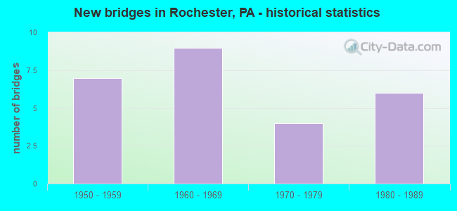
- New bridges - historical statistics
- 71950-1959
- 91960-1969
- 41970-1979
- 61980-1989

- Reconstructed bridges - Historical Statistics
- 11970-1979
- 01980-1989
- 21990-1999
- 22000-2009
- 22010-2019


- Bridge Condition - Deck
- 12.5%Very good
- 37.5%Good
- 37.5%Satisfactory
- 12.5%Poor

- Bridge Condition - Superstructure
- 75.0%Good
- 25.0%Satisfactory

- Bridge Condition - Substructure
- 12.5%Very good
- 62.5%Good
- 12.5%Satisfactory
- 12.5%Fair
Find on map >> Show street view
Structure Number: 3442, Location: ROCHESTER MONACA BRIDGE (Lat: 40.694000, Lng: -80.281489), Route carried "on" structure: State highway 18, Year Built: 1986, Status: Open, Structure Length: 64.50m (211.61ft), Average Daily Traffic: 15,988 (year 2021), Truck Traffic: 2%, Average Future Daily Traffic: 13,313 (year 2040), Design Load: HS 20, Features Intersected: SR 65,RR,LOCAL,OHIO RIV., Facility Carried by Structure: ROCHESTER MONACA
Minimum Vertical Clearance: 4.47m (14.67ft), Kilometerpoint: 33.748, Lanes on structure: 2, Lanes under structure: 8, Base Highway Network: Yes, Owner: State Highway Agency, Approaching Roadway Width: 14.0m (45.9ft), Navigation Control: Yes ( Vertical Clearance: 21.0m (68.9ft), Horizontal Clearance: 229.8m (753.9ft)), Material/Design: Steel continuous, Design/Construction: Truss - Thru, Number Of Spans In Main Unit: 3, Number Of Approach Spans: 3, Length of Maximum Span: 237.7m (779.9ft), Curb or Sidewalk Widths: Left: 0.0m, Right: 1.7m (5.6ft), Curb-To-Curb Width: 11.0m (36.1ft), Out-to-Out Width: 12.0m (39.4ft)
Condition: Deck: Satisfactory, Superstructure: Satisfactory, Substructure: Satisfactory, Channel: Very good, Operating Rating: 62.6 metric tons, Method Used To Determine Operating Rating: Load Factor (LF), Inventory Rating: 37.2 metric tons, Method Used To Determine Inventory Rating: Load Factor (LF), Structural Evaluation: Equal to present minimum criteria, Deck Geometry: Meets minimum limits, Underclear: High priority of corrective action, Waterway Adequacy: Superior to present desirable criteria, Approach Roadway Alignment: Equal to present desirable criteria, Length Of Structure Improvement: 64.50m (211.61ft), Designated Inspection Frequency: Every 24 months, Critical Feature Inspection Frequency: Every 24 months, Underwater Inspection Frequency: Every 60 months, Inspection Date: July 2021, Critical Feature Inspection Date: July 2021, Underwater Inspection Date: August 2020, Bridge Improvement Cost: $158,000, Roadway Improvement Cost: $464,000, Total Project Cost: $2,127,000, Deck Structure Type: Concrete Cast-file-Place, Wearing Surface/Protective System: Wearing Surface: Monolithic Concrete, Deck Protection: Epoxy Coated Reinforcing
Find on map >> Show street view
Structure Number: 3485, Location: 750' NORTH ROCH.MONACA BR (Lat: 40.699722, Lng: -80.279592), Route carried "on" structure: State highway 51, Year Built: 1965, Year Reconstructed: 1997, Status: Open, Structure Length: 22.86m (75.00ft), Average Daily Traffic: 9,016 (year 2021), Truck Traffic: 6%, Average Future Daily Traffic: 8,745 (year 2032), Design Load: HS 20, Features Intersected: 04136,641 RP.A,& LOCAL
Minimum Vertical Clearance: 30+ m (98+ ft), Kilometerpoint: 16.055, Lanes on structure: 4, Lanes under structure: 4, Base Highway Network: Yes, Owner: State Highway Agency, Approaching Roadway Width: 8.2m (26.9ft), Skew: 39 degrees, Material/Design: Prestressed concrete, Design/Construction: Box Beam or Girders - Single/Spread, Number Of Spans In Main Unit: 2, Number Of Approach Spans: 10, Length of Maximum Span: 26.8m (87.9ft), Curb or Sidewalk Widths: Left: 0.2m (0.7ft), Right: 0.2m (0.7ft), Curb-To-Curb Width: 8.2m (26.9ft), Out-to-Out Width: 9.2m (30.2ft)
Condition: Deck: Good, Superstructure: Good, Substructure: Good, Operating Rating: 70.8 metric tons, Method Used To Determine Operating Rating: Load Factor (LF), Inventory Rating: 19.1 metric tons, Method Used To Determine Inventory Rating: Load Factor (LF), Structural Evaluation: Meets minimum limits, Deck Geometry: High priority of replacement, Underclear: High priority of corrective action, Approach Roadway Alignment: Better than present minimum criteria, Length Of Structure Improvement: 30.10m (98.75ft), Designated Inspection Frequency: Every 24 months, Inspection Date: August 2021, Deck Structure Type: Concrete Cast-file-Place, Wearing Surface/Protective System: Wearing Surface: Epoxy Overlay, Deck Protection: Epoxy Coated Reinforcing
Find on map >> Show street view
Structure Number: 3672, Location: 1500' E. OF ROCH-MONA.BR. (Lat: 40.700000, Lng: -80.283333), Route carried "on" structure: State highway , Year Built: 1970, Year Reconstructed: 2014, Status: Open, Structure Length: 21.64m (71.00ft), Average Daily Traffic: 552 (year 2020), Truck Traffic: 45%, Average Future Daily Traffic: 2,249 (year 2032), Design Load: HL 93, Features Intersected: NORFOLKSOUTH RR, Facility Carried by Structure: NEW YORK AVE
Minimum Vertical Clearance: 30+ m (98+ ft), Kilometerpoint: 0.000, Lanes on structure: 2, Lanes under structure: 6, Owner: State Highway Agency, Approaching Roadway Width: 9.4m (30.8ft), Skew: 9 degrees, Material/Design: Prestressed concrete, Design/Construction: Stringer/Multi-beam, Number Of Spans In Main Unit: 9, Number Of Approach Spans: 3, Length of Maximum Span: 24.1m (79.1ft), Curb or Sidewalk Widths: Left: 0.2m (0.7ft), Right: 1.5m (4.9ft), Curb-To-Curb Width: 12.2m (40.0ft), Out-to-Out Width: 12.2m (40.0ft)
Condition: Deck: Very good, Superstructure: Satisfactory, Substructure: Good, Operating Rating: 51.7 metric tons, Method Used To Determine Operating Rating: Assigned ratings based on Load and Resistance Factor Design (LRFD) reported in metric tons, Inventory Rating: 21.8 metric tons, Method Used To Determine Inventory Rating: Assigned ratings based on Load and Resistance Factor Design (LRFD) reported in metric tons, Structural Evaluation: Somewhat better than minimum adequacy, Deck Geometry: Equal to present desirable criteria, Underclear: High priority of corrective action, Approach Roadway Alignment: Somewhat better than minimum adequacy, Length Of Structure Improvement: 21.20m (69.55ft), Designated Inspection Frequency: Every 24 months, Inspection Date: August 2021, Bridge Improvement Cost: $253,000, Roadway Improvement Cost: $744,000, Total Project Cost: $3,411,000, Deck Structure Type: Concrete Cast-file-Place, Wearing Surface/Protective System: Wearing Surface: Monolithic Concrete, Deck Protection: Epoxy Coated Reinforcing
Find on map >> Show street view
Structure Number: 3784, Location: Rochester-Bridgewater Bri (Lat: 40.701781, Lng: -80.289908), Route carried "on" structure: State highway , Year Built: 1957, Year Reconstructed: 1976, Status: Open, Structure Length: 2.16m (7.09ft), Average Daily Traffic: 2,786 (year 2020), Truck Traffic: 3%, Average Future Daily Traffic: 7,563 (year 2032), Design Load: HS 20, Features Intersected: LR 77(TR 18), Facility Carried by Structure: WEST MADISON ST
Minimum Vertical Clearance: 30+ m (98+ ft), Kilometerpoint: 0.724, Lanes on structure: 2, Lanes under structure: 8, Owner: State Highway Agency, Approaching Roadway Width: 14.0m (45.9ft), Material/Design: Prestressed concrete, Design/Construction: Box Beam or Girders - Single/Spread, Number Of Spans In Main Unit: 1, Length of Maximum Span: 20.7m (67.9ft), Curb or Sidewalk Widths: Left: 1.5m (4.9ft), Right: 1.5m (4.9ft), Curb-To-Curb Width: 9.8m (32.2ft), Out-to-Out Width: 13.6m (44.6ft)
Condition: Deck: Poor, Superstructure: Good, Substructure: Good, Operating Rating: 77.1 metric tons, Method Used To Determine Operating Rating: Load Factor (LF), Inventory Rating: 24.5 metric tons, Method Used To Determine Inventory Rating: Load Factor (LF), Structural Evaluation: Equal to present minimum criteria, Deck Geometry: Meets minimum limits, Underclear: Equal to present minimum criteria, Approach Roadway Alignment: Equal to present desirable criteria, Length Of Structure Improvement: 2.20m (7.22ft), Designated Inspection Frequency: Every 24 months, Other Special Inspection Frequency: Every 6 months, Inspection Date: September 2021, Other Special Inspection Date: September 2021, Bridge Improvement Cost: $13,000, Roadway Improvement Cost: $37,000, Total Project Cost: $171,000, Deck Structure Type: Concrete Cast-file-Place, Wearing Surface/Protective System: Wearing Surface: Monolithic Concrete, Deck Protection: Epoxy Coated Reinforcing
Find on map >> Show street view
Structure Number: 3923, Location: RAMP F OVER TR 51 & 65 NB (Lat: 40.700000, Lng: -80.291667), Route carried "on" structure: Ramp State highway , Year Built: 1959, Year Reconstructed: 2011, Status: Open, Structure Length: 3.02m (9.91ft), Average Daily Traffic: 6,467 (year 2022), Truck Traffic: 7%, Average Future Daily Traffic: 13,595 (year 2031), Design Load: HS 20, Features Intersected: RAMP D 51 & 65 N.B., Facility Carried by Structure: RAMP F
Minimum Vertical Clearance: 30+ m (98+ ft), Kilometerpoint: 0.000, Lanes on structure: 1, Lanes under structure: 2, Base Highway Network: Yes, Owner: State Highway Agency, Approaching Roadway Width: 8.2m (26.9ft), Skew: 4 degrees, Material/Design: Steel, Design/Construction: Stringer/Multi-beam, Number Of Spans In Main Unit: 1, Length of Maximum Span: 28.3m (92.8ft), Curb or Sidewalk Widths: Left: 0.2m (0.7ft), Right: 0.2m (0.7ft), Curb-To-Curb Width: 7.9m (25.9ft), Out-to-Out Width: 9.1m (29.9ft)
Condition: Deck: Satisfactory, Superstructure: Good, Substructure: Good, Operating Rating: 85.3 metric tons, Method Used To Determine Operating Rating: Load Factor (LF), Inventory Rating: 50.8 metric tons, Method Used To Determine Inventory Rating: Load Factor (LF), Structural Evaluation: Better than present minimum criteria, Deck Geometry: Equal to present desirable criteria, Underclear: Superior to present desirable criteria, Approach Roadway Alignment: Equal to present desirable criteria, Length Of Structure Improvement: 3.00m (9.84ft), Designated Inspection Frequency: Every 24 months, Inspection Date: August 2021, Deck Structure Type: Concrete Cast-file-Place, Wearing Surface/Protective System: Wearing Surface: Monolithic Concrete, Deck Protection: Epoxy Coated Reinforcing
Find on map >> Show street view
Structure Number: 3924, Location: Rochester-Bridgewater Bri (Lat: 40.691667, Lng: -80.283333), Route carried "on" structure: Ramp State highway , Year Built: 1956, Year Reconstructed: 2010, Status: Open, Structure Length: 9.14m (29.99ft), Average Daily Traffic: 5,398 (year 2022), Truck Traffic: 5%, Average Future Daily Traffic: 14,518 (year 2032), Design Load: HS 20, Features Intersected: SR 0051, Facility Carried by Structure: RAMP A
Minimum Vertical Clearance: 30+ m (98+ ft), Kilometerpoint: 0.000, Lanes on structure: 1, Base Highway Network: Yes, Owner: State Highway Agency, Approaching Roadway Width: 7.9m (25.9ft), Skew: 9 degrees, Material/Design: Steel, Design/Construction: Stringer/Multi-beam, Number Of Spans In Main Unit: 4, Number Of Approach Spans: 1, Length of Maximum Span: 32.9m (107.9ft), Curb or Sidewalk Widths: Left: 0.2m (0.7ft), Right: 0.2m (0.7ft), Curb-To-Curb Width: 7.6m (24.9ft), Out-to-Out Width: 8.7m (28.5ft)
Condition: Deck: Satisfactory, Superstructure: Good, Substructure: Fair, Operating Rating: 66.2 metric tons, Method Used To Determine Operating Rating: Load Factor (LF), Inventory Rating: 39.9 metric tons, Method Used To Determine Inventory Rating: Load Factor (LF), Structural Evaluation: Somewhat better than minimum adequacy, Deck Geometry: Better than present minimum criteria, Approach Roadway Alignment: Equal to present minimum criteria, Length Of Structure Improvement: 6.90m (22.64ft), Designated Inspection Frequency: Every 24 months, Critical Feature Inspection Frequency: Every 24 months, Inspection Date: August 2020, Critical Feature Inspection Date: August 2020, Deck Structure Type: Concrete Cast-file-Place, Wearing Surface/Protective System: Wearing Surface: Monolithic Concrete, Deck Protection: Epoxy Coated Reinforcing
Find on map >> Show street view
Structure Number: 3925, Location: OVER SR 65 NB (Lat: 40.700000, Lng: -80.291667), Route carried "on" structure: Ramp State highway , Year Built: 1963, Year Reconstructed: 2019, Status: Open, Structure Length: 20.48m (67.19ft), Average Daily Traffic: 2,219 (year 2022), Truck Traffic: 1%, Average Future Daily Traffic: 5,138 (year 2032), Design Load: HS 20, Features Intersected: SR 0065 NB, Facility Carried by Structure: RAMP E
Minimum Vertical Clearance: 30+ m (98+ ft), Kilometerpoint: 0.000, Lanes on structure: 1, Lanes under structure: 2, Base Highway Network: Yes, Owner: State Highway Agency, Approaching Roadway Width: 5.5m (18.0ft), Skew: 9 degrees, Material/Design: Prestressed concrete, Design/Construction: Box Beam or Girders - Single/Spread, Number Of Spans In Main Unit: 9, Number Of Approach Spans: 6, Length of Maximum Span: 18.6m (61.0ft), Curb or Sidewalk Widths: Left: 0.6m (2.0ft), Right: 0.6m (2.0ft), Curb-To-Curb Width: 5.6m (18.4ft), Out-to-Out Width: 7.5m (24.6ft)
Condition: Deck: Good, Superstructure: Good, Substructure: Very good, Operating Rating: 59.0 metric tons, Method Used To Determine Operating Rating: Load Factor (LF), Inventory Rating: 35.4 metric tons, Method Used To Determine Inventory Rating: Load Factor (LF), Structural Evaluation: Better than present minimum criteria, Deck Geometry: Meets minimum limits, Underclear: High priority of corrective action, Approach Roadway Alignment: Equal to present minimum criteria, Length Of Structure Improvement: 20.50m (67.26ft), Designated Inspection Frequency: Every 24 months, Inspection Date: August 2020, Bridge Improvement Cost: $37,000, Roadway Improvement Cost: $108,000, Total Project Cost: $497,000, Deck Structure Type: Concrete Cast-file-Place, Wearing Surface/Protective System: Wearing Surface: Latex Concrete
Find on map >> Show street view
Structure Number: 52582, Location: 980' SOUTH ROCH.MONACA BR (Lat: 40.699583, Lng: -80.278856), Route carried "on" structure: State highway 51, Year Built: 1965, Year Reconstructed: 1997, Status: Open, Structure Length: 29.87m (98.00ft), Average Daily Traffic: 9,494 (year 2021), Truck Traffic: 6%, Average Future Daily Traffic: 9,364 (year 2032), Design Load: HS 20, Features Intersected: 04136,641 RP.A,& LOCAL
Minimum Vertical Clearance: 30+ m (98+ ft), Kilometerpoint: 16.029, Lanes on structure: 4, Lanes under structure: 4, Base Highway Network: Yes, Owner: State Highway Agency, Approaching Roadway Width: 8.2m (26.9ft), Skew: 39 degrees, Material/Design: Prestressed concrete, Design/Construction: Box Beam or Girders - Single/Spread, Number Of Spans In Main Unit: 2, Number Of Approach Spans: 14, Length of Maximum Span: 26.8m (87.9ft), Curb or Sidewalk Widths: Left: 0.2m (0.7ft), Right: 0.2m (0.7ft), Curb-To-Curb Width: 8.2m (26.9ft), Out-to-Out Width: 9.2m (30.2ft)
Condition: Deck: Good, Superstructure: Good, Substructure: Good, Operating Rating: 71.7 metric tons, Method Used To Determine Operating Rating: Load Factor (LF), Inventory Rating: 20.9 metric tons, Method Used To Determine Inventory Rating: Load Factor (LF), Structural Evaluation: Somewhat better than minimum adequacy, Deck Geometry: High priority of replacement, Underclear: High priority of corrective action, Approach Roadway Alignment: Better than present minimum criteria, Designated Inspection Frequency: Every 24 months, Inspection Date: August 2021, Deck Structure Type: Concrete Cast-file-Place, Wearing Surface/Protective System: Wearing Surface: Epoxy Overlay, Deck Protection: Epoxy Coated Reinforcing
Find on map >> Show street view
Structure Number: 3442, Location: ROCHESTER MONACA BRIDGE (Lat: 40.694000, Lng: -80.281489), Route carried "under" structure: State highway 51, Year Built: 1986, Structure Length: 0. m, Average Daily Traffic: 9,016 (year 2021), Truck Traffic: 6%, Features Intersected: SR 65,RR,LOCAL,OHIO RIV., Facility Carried by Structure: ROCHESTER MONACA
Minimum Vertical Clearance: 8.89m (29.17ft), Kilometerpoint: 16.055, Lanes on structure: 2, Lanes under structure: 2, Material/Design: Steel continuous, Design/Construction: Truss - Thru, Length of Maximum Span: 237.7m (779.9ft)
Find on map >> Show street view
Structure Number: 3442, Location: ROCHESTER MONACA BRIDGE (Lat: 40.694000, Lng: -80.281489), Route carried "under" structure: State highway 51, Year Built: 1986, Structure Length: 0. m, Average Daily Traffic: 9,494 (year 2021), Truck Traffic: 6%, Features Intersected: SR 65,RR,LOCAL,OHIO RIV., Facility Carried by Structure: ROCHESTER MONACA
Minimum Vertical Clearance: 8.61m (28.25ft), Kilometerpoint: 16.029, Lanes on structure: 2, Lanes under structure: 2, Material/Design: Steel continuous, Design/Construction: Truss - Thru, Length of Maximum Span: 237.7m (779.9ft)
Find on map >> Show street view
Structure Number: 3442, Location: ROCHESTER MONACA BRIDGE (Lat: 40.694000, Lng: -80.281489), Route carried "under" structure: State highway 18, Year Built: 1986, Structure Length: 0. m, Average Daily Traffic: 8,275 (year 2020), Truck Traffic: 4%, Features Intersected: SR 65,RR,LOCAL,OHIO RIV., Facility Carried by Structure: ROCHESTER MONACA
Minimum Vertical Clearance: 22.15m (72.67ft), Kilometerpoint: 34.393, Lanes on structure: 2, Lanes under structure: 1, Material/Design: Steel continuous, Design/Construction: Truss - Thru, Length of Maximum Span: 237.7m (779.9ft)
Find on map >> Show street view
Structure Number: 3442, Location: ROCHESTER MONACA BRIDGE (Lat: 40.694000, Lng: -80.281489), Route carried "under" structure: State highway 18, Year Built: 1986, Structure Length: 0. m, Average Daily Traffic: 8,918 (year 2020), Truck Traffic: 4%, Features Intersected: SR 65,RR,LOCAL,OHIO RIV., Facility Carried by Structure: ROCHESTER MONACA
Minimum Vertical Clearance: 22.15m (72.67ft), Kilometerpoint: 34.393, Lanes on structure: 2, Lanes under structure: 1, Material/Design: Steel continuous, Design/Construction: Truss - Thru, Length of Maximum Span: 237.7m (779.9ft)
Find on map >> Show street view
Structure Number: 3442, Location: ROCHESTER MONACA BRIDGE (Lat: 40.694000, Lng: -80.281489), Route carried "under" structure: City street , Year Built: 1986, Structure Length: 0. m, Average Daily Traffic: 300 (year 2019), Truck Traffic: 5%, Features Intersected: SR 65,RR,LOCAL,OHIO RIV., Facility Carried by Structure: ROCHESTER MONACA
Minimum Vertical Clearance: 22.10m (72.51ft), Kilometerpoint: 0.000, Lanes on structure: 2, Lanes under structure: 2, Material/Design: Steel continuous, Design/Construction: Truss - Thru, Length of Maximum Span: 237.7m (779.9ft)
Find on map >> Show street view
Structure Number: 3485, Location: 750' NORTH ROCH.MONACA BR (Lat: 40.699722, Lng: -80.279592), Route carried "under" structure: State highway , Year Built: 1965, Structure Length: 0. m, Average Daily Traffic: 552 (year 2020), Truck Traffic: 45%, Features Intersected: 04136,641 RP.A,& LOCAL, Facility Carried by Structure: SR 51
Minimum Vertical Clearance: 5.66m (18.57ft), Kilometerpoint: 0.000, Lanes on structure: 4, Lanes under structure: 2, Material/Design: Prestressed concrete, Design/Construction: Box Beam or Girders - Single/Spread, Length of Maximum Span: 26.8m (87.9ft)
Find on map >> Show street view
Structure Number: 3485, Location: 750' NORTH ROCH.MONACA BR (Lat: 40.699722, Lng: -80.279592), Route carried "under" structure: Ramp State highway , Year Built: 1965, Structure Length: 0. m, Average Daily Traffic: 4,089 (year 2022), Truck Traffic: 7%, Features Intersected: 04136,641 RP.A,& LOCAL, Facility Carried by Structure: SR 51
Minimum Vertical Clearance: 5.00m (16.40ft), Kilometerpoint: 0.000, Lanes on structure: 4, Lanes under structure: 1, Material/Design: Prestressed concrete, Design/Construction: Box Beam or Girders - Single/Spread, Length of Maximum Span: 26.8m (87.9ft)
Find on map >> Show street view
Structure Number: 3485, Location: 750' NORTH ROCH.MONACA BR (Lat: 40.699722, Lng: -80.279592), Route carried "under" structure: City street , Year Built: 1965, Structure Length: 0. m, Average Daily Traffic: 20 (year 1993), Truck Traffic: 1%, Features Intersected: 04136,641 RP.A,& LOCAL, Facility Carried by Structure: SR 51
Minimum Vertical Clearance: 7.62m (25.00ft), Kilometerpoint: 0.000, Lanes on structure: 4, Lanes under structure: 1, Material/Design: Prestressed concrete, Design/Construction: Box Beam or Girders - Single/Spread, Length of Maximum Span: 26.8m (87.9ft)
Find on map >> Show street view
Structure Number: 3672, Location: 1500' E. OF ROCH-MONA.BR. (Lat: 40.700000, Lng: -80.283333), Route carried "under" structure: State highway 1032, Year Built: 1970, Structure Length: 0. m, Average Daily Traffic: 3,791 (year 2006), Truck Traffic: 1%, Features Intersected: NORFOLKSOUTH RR, Facility Carried by Structure: NEW YORK AVE
Minimum Vertical Clearance: 7.99m (26.21ft), Kilometerpoint: 0.000, Lanes on structure: 2, Lanes under structure: 2, Material/Design: Prestressed concrete, Design/Construction: Stringer/Multi-beam, Length of Maximum Span: 24.1m (79.1ft)
Find on map >> Show street view
Structure Number: 3672, Location: 1500' E. OF ROCH-MONA.BR. (Lat: 40.700000, Lng: -80.283333), Route carried "under" structure: State highway , Year Built: 1970, Structure Length: 0. m, Average Daily Traffic: 552 (year 2020), Truck Traffic: 45%, Features Intersected: NORFOLKSOUTH RR, Facility Carried by Structure: NEW YORK AVE
Minimum Vertical Clearance: 30+ m (98+ ft), Kilometerpoint: 0.000, Lanes on structure: 2, Lanes under structure: 2, Material/Design: Prestressed concrete, Design/Construction: Stringer/Multi-beam, Length of Maximum Span: 24.1m (79.1ft)
Find on map >> Show street view
Structure Number: 3672, Location: 1500' E. OF ROCH-MONA.BR. (Lat: 40.700000, Lng: -80.283333), Route carried "under" structure: City street , Year Built: 1970, Structure Length: 0. m, Average Daily Traffic: 10 (year 2006), Truck Traffic: 1%, Features Intersected: NORFOLKSOUTH RR, Facility Carried by Structure: NEW YORK AVE
Minimum Vertical Clearance: 5.72m (18.77ft), Kilometerpoint: 0.000, Lanes on structure: 2, Lanes under structure: 2, Material/Design: Prestressed concrete, Design/Construction: Stringer/Multi-beam, Length of Maximum Span: 24.1m (79.1ft)
Find on map >> Show street view
Structure Number: 3784, Location: Rochester-Bridgewater Bri (Lat: 40.701781, Lng: -80.289908), Route carried "under" structure: State highway 18, Year Built: 1957, Structure Length: 0. m, Average Daily Traffic: 8,918 (year 2020), Truck Traffic: 4%, Features Intersected: LR 77(TR 18), Facility Carried by Structure: WEST MADISON ST
Minimum Vertical Clearance: 5.11m (16.77ft), Kilometerpoint: 35.010, Lanes on structure: 2, Lanes under structure: 4, Material/Design: Prestressed concrete, Design/Construction: Box Beam or Girders - Single/Spread, Length of Maximum Span: 20.7m (67.9ft)
Find on map >> Show street view
Structure Number: 3784, Location: Rochester-Bridgewater Bri (Lat: 40.701781, Lng: -80.289908), Route carried "under" structure: State highway 18, Year Built: 1957, Structure Length: 0. m, Average Daily Traffic: 8,275 (year 2020), Truck Traffic: 4%, Features Intersected: LR 77(TR 18), Facility Carried by Structure: WEST MADISON ST
Minimum Vertical Clearance: 4.85m (15.91ft), Kilometerpoint: 35.040, Lanes on structure: 2, Lanes under structure: 4, Material/Design: Prestressed concrete, Design/Construction: Box Beam or Girders - Single/Spread, Length of Maximum Span: 20.7m (67.9ft)
Find on map >> Show street view
Structure Number: 3923, Location: RAMP F OVER TR 51 & 65 NB (Lat: 40.700000, Lng: -80.291667), Route carried "under" structure: Ramp State highway , Year Built: 1959, Structure Length: 0. m, Average Daily Traffic: 4,631 (year 2022), Truck Traffic: 7%, Features Intersected: RAMP D 51 & 65 N.B., Facility Carried by Structure: RAMP F
Minimum Vertical Clearance: 5.73m (18.80ft), Kilometerpoint: 0.000, Lanes on structure: 1, Lanes under structure: 1, Material/Design: Steel, Design/Construction: Stringer/Multi-beam, Length of Maximum Span: 28.3m (92.8ft)
Find on map >> Show street view
Structure Number: 3923, Location: RAMP F OVER TR 51 & 65 NB (Lat: 40.700000, Lng: -80.291667), Route carried "under" structure: Ramp State highway , Year Built: 1959, Structure Length: 0. m, Average Daily Traffic: 712 (year 2022), Truck Traffic: 3%, Features Intersected: RAMP D 51 & 65 N.B., Facility Carried by Structure: RAMP F
Minimum Vertical Clearance: 5.73m (18.80ft), Kilometerpoint: 0.000, Lanes on structure: 1, Lanes under structure: 1, Material/Design: Steel, Design/Construction: Stringer/Multi-beam, Length of Maximum Span: 28.3m (92.8ft)
Find on map >> Show street view
Structure Number: 3925, Location: OVER SR 65 NB (Lat: 40.700000, Lng: -80.291667), Route carried "under" structure: State highway 18, Year Built: 1963, Structure Length: 0. m, Average Daily Traffic: 8,918 (year 2020), Truck Traffic: 4%, Features Intersected: SR 0065 NB, Facility Carried by Structure: RAMP E
Minimum Vertical Clearance: 4.55m (14.93ft), Kilometerpoint: 34.393, Lanes on structure: 1, Lanes under structure: 2, Material/Design: Prestressed concrete, Design/Construction: Box Beam or Girders - Single/Spread, Length of Maximum Span: 18.6m (61.0ft)
Find on map >> Show street view
Structure Number: 52582, Location: 980' SOUTH ROCH.MONACA BR (Lat: 40.699583, Lng: -80.278856), Route carried "under" structure: State highway , Year Built: 1965, Structure Length: 0. m, Average Daily Traffic: 552 (year 2020), Truck Traffic: 45%, Features Intersected: 04136,641 RP.A,& LOCAL, Facility Carried by Structure: SR 51 SB
Minimum Vertical Clearance: 4.70m (15.42ft), Kilometerpoint: 0.000, Lanes on structure: 4, Lanes under structure: 2, Material/Design: Prestressed concrete, Design/Construction: Box Beam or Girders - Single/Spread, Length of Maximum Span: 26.8m (87.9ft)
Find on map >> Show street view
Structure Number: 52582, Location: 980' SOUTH ROCH.MONACA BR (Lat: 40.699583, Lng: -80.278856), Route carried "under" structure: Ramp State highway , Year Built: 1965, Structure Length: 0. m, Average Daily Traffic: 4,089 (year 2022), Truck Traffic: 7%, Features Intersected: 04136,641 RP.A,& LOCAL, Facility Carried by Structure: SR 51 SB
Minimum Vertical Clearance: 4.27m (14.01ft), Kilometerpoint: 0.000, Lanes on structure: 4, Lanes under structure: 1, Material/Design: Prestressed concrete, Design/Construction: Box Beam or Girders - Single/Spread, Length of Maximum Span: 26.8m (87.9ft)