Bridge Statistics for Robbinsdale, Minnesota (MN)
Condition, Traffic, Stress, Structural Evaluation, Project Costs
- National Bridge Inventory (NBI) Statistics
- 26Number of bridges
- 364ft / 111mTotal length
- $171,000,000Total costs
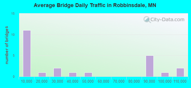
- 887,542Total average daily traffic
- 39,726Total average daily truck traffic
- National Bridge Inventory (NBI) Registered Bridges for Robbinsdale
- No street view available for this location

- New bridges - historical statistics
- 31960-1969
- 11970-1979
- 192000-2009
- 32020-2022
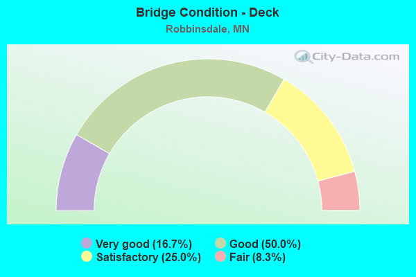
- Bridge Condition - Deck
- 16.7%Very good
- 50.0%Good
- 25.0%Satisfactory
- 8.3%Fair
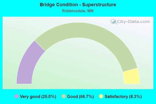
- Bridge Condition - Superstructure
- 25.0%Very good
- 66.7%Good
- 8.3%Satisfactory
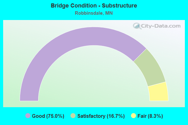
- Bridge Condition - Substructure
- 75.0%Good
- 16.7%Satisfactory
- 8.3%Fair
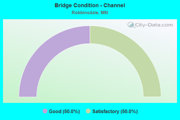
- Bridge Condition - Channel
- 50.0%Good
- 50.0%Satisfactory
Find on map >> Show street view
Structure Number: 27081, Location: 0.4 MI W OF JCT CSAH 81 (Lat: 45.020489, Lng: -93.332786), Route carried "on" structure: City street 125, Year Built: 1977, Status: Open, Structure Length: 4.08m (13.39ft), Average Daily Traffic: 11,700 (year 2017), Average Future Daily Traffic: 11,700 (year 2039), Design Load: HS 20, Features Intersected: BNSF RR
Minimum Vertical Clearance: 30+ m (98+ ft), Kilometerpoint: 0.000, Lanes on structure: 4, Owner: City or Municipal Highway Agency, Approaching Roadway Width: 14.6m (47.9ft), Skew: 1 degrees, Material/Design: Steel continuous, Design/Construction: Stringer/Multi-beam, Number Of Spans In Main Unit: 3, Length of Maximum Span: 15.1m (49.5ft), Curb or Sidewalk Widths: Left: 1.8m (5.9ft), Right: 1.8m (5.9ft), Curb-To-Curb Width: 14.6m (47.9ft), Out-to-Out Width: 19.0m (62.3ft)
Condition: Deck: Good, Superstructure: Good, Substructure: Good, Operating Rating: 46.7 metric tons, Method Used To Determine Operating Rating: Load Factor (LF), Inventory Rating: 28.1 metric tons, Method Used To Determine Inventory Rating: Load Factor (LF), Structural Evaluation: Better than present minimum criteria, Deck Geometry: High priority of replacement, Underclear: Equal to present desirable criteria, Approach Roadway Alignment: Equal to present desirable criteria, Length Of Structure Improvement: 1.49m (4.89ft), Designated Inspection Frequency: Every 24 months, Inspection Date: October 2020, Bridge Improvement Cost: $999,999,000, Roadway Improvement Cost: $15,000,000, Total Project Cost: $171,000,000, Deck Structure Type: Concrete Cast-file-Place, Wearing Surface/Protective System: Wearing Surface: Low Slump Concrete
Find on map >> Show street view
Structure Number: 27168, Location: 2.5 MI N OF JCT TH 55 (Lat: 45.021150, Lng: -93.348708), Route carried "on" structure: City street 206, Year Built: 2000, Status: Open, Structure Length: 6.08m (19.95ft), Average Daily Traffic: 20,700 (year 2017), Average Future Daily Traffic: 20,700 (year 2039), Design Load: HS 25 or greater, Features Intersected: TH 100
Minimum Vertical Clearance: 30+ m (98+ ft), Kilometerpoint: 0.000, Lanes on structure: 7, Lanes under structure: 6, Owner: State Highway Agency, Approaching Roadway Width: 28.0m (91.9ft), Skew: 31 degrees, Material/Design: Prestressed concrete, Design/Construction: Stringer/Multi-beam, Number Of Spans In Main Unit: 2, Length of Maximum Span: 29.6m (97.1ft), Curb or Sidewalk Widths: Left: 2.4m (7.9ft), Right: 2.4m (7.9ft), Curb-To-Curb Width: 28.0m (91.9ft), Out-to-Out Width: 35.1m (115.2ft)
Condition: Deck: Good, Superstructure: Good, Substructure: Good, Operating Rating: 70.7 metric tons, Method Used To Determine Operating Rating: Load Factor (LF), Inventory Rating: 41.0 metric tons, Method Used To Determine Inventory Rating: Load Factor (LF), Structural Evaluation: Better than present minimum criteria, Deck Geometry: Somewhat better than minimum adequacy, Underclear: Equal to present minimum criteria, Approach Roadway Alignment: Equal to present desirable criteria, Designated Inspection Frequency: Every 24 months, Inspection Date: July 2021, Deck Structure Type: Concrete Cast-file-Place, Wearing Surface/Protective System: Wearing Surface: Monolithic Concrete, Deck Protection: Other
Find on map >> Show street view
Structure Number: 2717, Location: THE JCT TH 100; CMSA 8 (Lat: 45.035139, Lng: -93.344233), Route carried "on" structure: County highway 8, Year Built: 2001, Status: Open, Structure Length: 9.79m (32.12ft), Average Daily Traffic: 3,700 (year 2017), Average Future Daily Traffic: 3,700 (year 2039), Design Load: HS 25 or greater, Features Intersected: TH 100; RAMPS
Minimum Vertical Clearance: 30+ m (98+ ft), Kilometerpoint: 0.000, Lanes on structure: 2, Lanes under structure: 9, Owner: State Highway Agency, Approaching Roadway Width: 13.4m (44.0ft), Material/Design: Prestressed concrete, Design/Construction: Stringer/Multi-beam, Number Of Spans In Main Unit: 4, Length of Maximum Span: 26.9m (88.3ft), Curb or Sidewalk Widths: Left: 2.4m (7.9ft), Right: 2.4m (7.9ft), Curb-To-Curb Width: 13.4m (44.0ft), Out-to-Out Width: 19.2m (63.0ft)
Condition: Deck: Good, Superstructure: Good, Substructure: Good, Operating Rating: 80.4 metric tons, Method Used To Determine Operating Rating: Load Factor (LF), Inventory Rating: 48.0 metric tons, Method Used To Determine Inventory Rating: Load Factor (LF), Structural Evaluation: Better than present minimum criteria, Deck Geometry: Better than present minimum criteria, Underclear: Equal to present minimum criteria, Approach Roadway Alignment: Equal to present desirable criteria, Designated Inspection Frequency: Every 24 months, Inspection Date: July 2021, Deck Structure Type: Concrete Cast-file-Place, Wearing Surface/Protective System: Wearing Surface: Monolithic Concrete, Deck Protection: Epoxy Coated Reinforcing
Find on map >> Show street view
Structure Number: 27203, Location: At jct TH 100; CSAH 81 (Lat: 45.036378, Lng: -93.342986), Route carried "on" structure: County highway 81, Year Built: 2001, Status: Open, Structure Length: 6.65m (21.82ft), Average Daily Traffic: 35,000 (year 2017), Average Future Daily Traffic: 35,000 (year 2039), Design Load: HS 25 or greater, Features Intersected: TH 100
Minimum Vertical Clearance: 30+ m (98+ ft), Kilometerpoint: 0.000, Lanes on structure: 5, Lanes under structure: 6, Owner: State Highway Agency, Approaching Roadway Width: 22.6m (74.1ft), Skew: 22 degrees, Material/Design: Prestressed concrete, Design/Construction: Stringer/Multi-beam, Number Of Spans In Main Unit: 2, Length of Maximum Span: 36.5m (119.8ft), Curb-To-Curb Width: 22.6m (74.1ft), Out-to-Out Width: 29.1m (95.5ft)
Condition: Deck: Good, Superstructure: Good, Substructure: Satisfactory, Operating Rating: 80.6 metric tons, Method Used To Determine Operating Rating: Load Factor (LF), Inventory Rating: 48.3 metric tons, Method Used To Determine Inventory Rating: Load Factor (LF), Structural Evaluation: Equal to present minimum criteria, Deck Geometry: Equal to present minimum criteria, Underclear: Somewhat better than minimum adequacy, Approach Roadway Alignment: Equal to present desirable criteria, Designated Inspection Frequency: Every 24 months, Inspection Date: July 2021, Deck Structure Type: Concrete Cast-file-Place, Wearing Surface/Protective System: Wearing Surface: Low Slump Concrete, Deck Protection: Epoxy Coated Reinforcing
Find on map >> Show street view
Structure Number: 27284, Location: 2.9 MI N OF JCT TH 55 (Lat: 45.026139, Lng: -93.347481), Route carried "on" structure: , Year Built: 2000, Status: Open, Structure Length: 17.12m (56.17ft), Features Intersected: TH 100, Facility Carried by Structure: PEDESTRIAN
Lanes under structure: 7, Owner: State Highway Agency, Material/Design: Steel continuous, Design/Construction: Stringer/Multi-beam, Number Of Spans In Main Unit: 2, Number Of Approach Spans: 10, Length of Maximum Span: 33.5m (109.9ft), Out-to-Out Width: 3.9m (12.8ft)
Condition: Deck: Satisfactory, Superstructure: Good, Substructure: Good, Underclear: Equal to present minimum criteria, Bridge Posting: Required (Relationship of Operating Rating to Maximum Legal Load: > 39.9% below), Designated Inspection Frequency: Every 24 months, Inspection Date: July 2021, Deck Structure Type: Concrete Cast-file-Place, Wearing Surface/Protective System: Wearing Surface: Monolithic Concrete, Deck Protection: Epoxy Coated Reinforcing
Find on map >> Show street view
Structure Number: 27285, Location: AT THE JCT TH100; CSAH9 (Lat: 45.031478, Lng: -93.347114), Route carried "on" structure: County highway 9, Year Built: 2001, Status: Open, Structure Length: 6.96m (22.83ft), Average Daily Traffic: 20,900 (year 2017), Average Future Daily Traffic: 20,900 (year 2039), Design Load: HS 20+Mod, Features Intersected: TH 100
Minimum Vertical Clearance: 30+ m (98+ ft), Kilometerpoint: 0.000, Lanes on structure: 6, Lanes under structure: 7, Owner: State Highway Agency, Approaching Roadway Width: 26.8m (87.9ft), Skew: 21 degrees, Material/Design: Prestressed concrete, Design/Construction: Stringer/Multi-beam, Number Of Spans In Main Unit: 2, Length of Maximum Span: 35.7m (117.1ft), Curb or Sidewalk Widths: Left: 2.9m (9.5ft), Right: 2.9m (9.5ft), Curb-To-Curb Width: 26.8m (87.9ft), Out-to-Out Width: 34.4m (112.9ft)
Condition: Deck: Satisfactory, Superstructure: Good, Substructure: Fair, Operating Rating: 90.5 metric tons, Method Used To Determine Operating Rating: Load Factor (LF), Inventory Rating: 54.5 metric tons, Method Used To Determine Inventory Rating: Load Factor (LF), Structural Evaluation: Somewhat better than minimum adequacy, Deck Geometry: Better than present minimum criteria, Underclear: Somewhat better than minimum adequacy, Approach Roadway Alignment: Equal to present desirable criteria, Designated Inspection Frequency: Every 24 months, Inspection Date: July 2021, Deck Structure Type: Concrete Cast-file-Place, Wearing Surface/Protective System: Wearing Surface: Monolithic Concrete, Deck Protection: Other
Find on map >> Show street view
Structure Number: 27286, Location: 3.5 MI N OF JCT TH 55 (Lat: 45.034908, Lng: -93.344597), Route carried "on" structure: , Year Built: 2001, Status: Open, Structure Length: 9.24m (30.31ft), Features Intersected: TH 100; RAMPS, Facility Carried by Structure: RAILROAD
Lanes under structure: 21, Owner: State Highway Agency, Skew: 2 degrees, Material/Design: Steel, Design/Construction: Stringer/Multi-beam, Number Of Spans In Main Unit: 4, Length of Maximum Span: 23.4m (76.8ft), Out-to-Out Width: 6.2m (20.3ft)
Condition: Deck: Satisfactory, Superstructure: Good, Substructure: Good, Underclear: Somewhat better than minimum adequacy, Bridge Posting: Required (Relationship of Operating Rating to Maximum Legal Load: > 39.9% below), Designated Inspection Frequency: Every 24 months, Inspection Date: July 2021, Deck Structure Type: Steel plate
Find on map >> Show street view
Structure Number: 27288, Location: 3.9 mi N of jct TH 55 (Lat: 45.038933, Lng: -93.339133), Route carried "on" structure: State highway 100, Year Built: 2001, Status: Open, Structure Length: 2.36m (7.74ft), Average Daily Traffic: 81,000 (year 2019), Truck Traffic: 4%, Average Future Daily Traffic: 37,500 (year 2039), Design Load: HS 25 or greater, Features Intersected: Twin Lake Channel
Minimum Vertical Clearance: 30+ m (98+ ft), Kilometerpoint: 0.000, Lanes on structure: 6, Base Highway Network: Yes, Owner: State Highway Agency, Approaching Roadway Width: 35.2m (115.5ft), Material/Design: Prestressed concrete, Design/Construction: Stringer/Multi-beam, Number Of Spans In Main Unit: 1, Length of Maximum Span: 22.3m (73.2ft), Curb or Sidewalk Widths: Left: 3.0m (9.8ft), Right: 0.0m, Curb-To-Curb Width: 35.2m (115.5ft), Out-to-Out Width: 40.6m (133.2ft)
Condition: Deck: Good, Superstructure: Very good, Substructure: Good, Channel: Good, Operating Rating: 77.1 metric tons, Method Used To Determine Operating Rating: Load Factor (LF), Inventory Rating: 43.4 metric tons, Method Used To Determine Inventory Rating: Load Factor (LF), Structural Evaluation: Better than present minimum criteria, Deck Geometry: Superior to present desirable criteria, Waterway Adequacy: Equal to present desirable criteria, Approach Roadway Alignment: Equal to present desirable criteria, Designated Inspection Frequency: Every 24 months, Inspection Date: October 2020, Deck Structure Type: Concrete Cast-file-Place, Wearing Surface/Protective System: Wearing Surface: Low Slump Concrete, Deck Protection: Epoxy Coated Reinforcing
Find on map >> Show street view
Structure Number: 27945, Location: AT W JCT TH 101; 94 (Lat: 45.194856, Lng: -93.552483), Route carried "on" structure: State highway 101, Year Built: 1969, Year Reconstructed: 1996, Status: Open, Structure Length: 9.24m (30.31ft), Average Daily Traffic: 44,088 (year 2019), Truck Traffic: 7%, Average Future Daily Traffic: 42,000 (year 2039), Design Load: HS 20, Features Intersected: I 94
Minimum Vertical Clearance: 30+ m (98+ ft), Kilometerpoint: 0.000, Lanes on structure: 5, Lanes under structure: 5, Base Highway Network: Yes, Owner: State Highway Agency, Approaching Roadway Width: 24.1m (79.1ft), Skew: 22 degrees, Material/Design: Prestressed concrete, Design/Construction: Stringer/Multi-beam, Number Of Spans In Main Unit: 4, Length of Maximum Span: 26.9m (88.3ft), Curb or Sidewalk Widths: Left: 0.0m, Right: 1.8m (5.9ft), Curb-To-Curb Width: 25.0m (82.0ft), Out-to-Out Width: 32.6m (107.0ft)
Condition: Deck: Fair, Superstructure: Satisfactory, Substructure: Satisfactory, Operating Rating: 75.7 metric tons, Method Used To Determine Operating Rating: Load Factor (LF), Inventory Rating: 27.9 metric tons, Method Used To Determine Inventory Rating: Load Factor (LF), Structural Evaluation: Equal to present minimum criteria, Deck Geometry: Superior to present desirable criteria, Underclear: Somewhat better than minimum adequacy, Approach Roadway Alignment: Equal to present desirable criteria, Designated Inspection Frequency: Every 24 months, Inspection Date: October 2020, Deck Structure Type: Concrete Cast-file-Place, Wearing Surface/Protective System: Wearing Surface: Low Slump Concrete
Find on map >> Show street view
Structure Number: 27A74, Location: THE JCTTH 100; France (Lat: 45.040994, Lng: -93.331108), Route carried "on" structure: ServiceCity street 371, Year Built: 2003, Status: Open, Structure Length: 21.99m (72.15ft), Average Daily Traffic: 1,000 (year 2003), Average Future Daily Traffic: 1,000 (year 2029), Design Load: HL 93, Features Intersected: DNR WETLAND
Minimum Vertical Clearance: 30+ m (98+ ft), Kilometerpoint: 0.000, Lanes on structure: 2, Owner: City or Municipal Highway Agency, Approaching Roadway Width: 8.5m (27.9ft), Material/Design: Prestressed concrete, Design/Construction: Stringer/Multi-beam, Number Of Spans In Main Unit: 8, Length of Maximum Span: 27.5m (90.2ft), Curb-To-Curb Width: 8.5m (27.9ft), Out-to-Out Width: 9.5m (31.2ft)
Condition: Deck: Good, Superstructure: Very good, Substructure: Good, Channel: Satisfactory, Operating Rating: 83.9 metric tons, Method Used To Determine Operating Rating: Load Factor (LF), Inventory Rating: 42.0 metric tons, Method Used To Determine Inventory Rating: Load Factor (LF), Structural Evaluation: Better than present minimum criteria, Deck Geometry: Somewhat better than minimum adequacy, Waterway Adequacy: Equal to present desirable criteria, Approach Roadway Alignment: Equal to present minimum criteria, Designated Inspection Frequency: Every 24 months, Inspection Date: October 2020, Deck Structure Type: Concrete Cast-file-Place, Wearing Surface/Protective System: Wearing Surface: Low Slump Concrete, Deck Protection: Epoxy Coated Reinforcing
Find on map >> Show street view
Structure Number: 27C63, Location: 1.75 MI W OF JCT TH 94 (Lat: 45.013389, Lng: -93.318881), Route carried "on" structure: County highway 81, Year Built: 2021, Status: Open, Structure Length: 11.27m (36.98ft), Average Daily Traffic: 5,250 (year 2017), Average Future Daily Traffic: 4,600 (year 2040), Design Load: HL 93, Features Intersected: MSAS 295; MUN 184
Minimum Vertical Clearance: 30+ m (98+ ft), Kilometerpoint: 0.000, Lanes on structure: 2, Lanes under structure: 5, Owner: County Highway Agency, Approaching Roadway Width: 8.5m (27.9ft), Material/Design: Prestressed concrete, Design/Construction: Stringer/Multi-beam, Number Of Spans In Main Unit: 2, Length of Maximum Span: 56.4m (185.0ft), Curb-To-Curb Width: 13.9m (45.6ft), Out-to-Out Width: 14.8m (48.6ft)
Condition: Deck: Very good, Superstructure: Very good, Substructure: Good, Operating Rating: 79.1 metric tons, Method Used To Determine Operating Rating: Load and Resistance Factor Rating (LRFR) rating reported by rating factor(RF) method using HL-93 loadings, Inventory Rating: 39.9 metric tons, Method Used To Determine Inventory Rating: Load and Resistance Factor Rating (LRFR) rating reported by rating factor(RF) method using HL-93 loadings, Structural Evaluation: Better than present minimum criteria, Deck Geometry: Superior to present desirable criteria, Underclear: High priority of corrective action, Approach Roadway Alignment: Better than present minimum criteria, Designated Inspection Frequency: Every 24 months, Inspection Date: November 2021, Deck Structure Type: Concrete Cast-file-Place, Wearing Surface/Protective System: Wearing Surface: Monolithic Concrete, Deck Protection: Epoxy Coated Reinforcing
Find on map >> Show street view
Structure Number: 27R06, Location: AT THE JCT TH100; CSAH81 (Lat: 45.037739, Lng: -93.340461), Route carried "on" structure: Ramp State highway 3435, Year Built: 2001, Status: Open, Structure Length: 6.06m (19.88ft), Average Daily Traffic: 1,000 (year 2002), Average Future Daily Traffic: 1,000 (year 2029), Design Load: HS 25 or greater, Features Intersected: FROM CSAH 81
Minimum Vertical Clearance: 30+ m (98+ ft), Kilometerpoint: 0.000, Lanes on structure: 2, Base Highway Network: Yes, Owner: State Highway Agency, Approaching Roadway Width: 12.2m (40.0ft), Material/Design: Prestressed concrete, Design/Construction: Stringer/Multi-beam, Number Of Spans In Main Unit: 2, Length of Maximum Span: 29.6m (97.1ft), Curb-To-Curb Width: 12.2m (40.0ft), Out-to-Out Width: 13.0m (42.7ft)
Condition: Deck: Very good, Superstructure: Good, Substructure: Good, Operating Rating: 71.4 metric tons, Method Used To Determine Operating Rating: Load Factor (LF), Inventory Rating: 39.2 metric tons, Method Used To Determine Inventory Rating: Load Factor (LF), Structural Evaluation: Better than present minimum criteria, Deck Geometry: Superior to present desirable criteria, Approach Roadway Alignment: Better than present minimum criteria, Length Of Structure Improvement: 2.04m (6.69ft), Designated Inspection Frequency: Every 24 months, Inspection Date: October 2020, Bridge Improvement Cost: $945,000,000, Deck Structure Type: Concrete Cast-file-Place, Wearing Surface/Protective System: Wearing Surface: Monolithic Concrete, Deck Protection: Epoxy Coated Reinforcing
Find on map >> Show street view
Structure Number: 27006, Location: 2.2 MI NW OF JCT TH 94 (Lat: 45.013947, Lng: -93.318694), Route carried "under" structure: City street 184, Year Built: 1964, Structure Length: 0. m, Average Daily Traffic: 9,000 (year 1996), Features Intersected: STR 184(VICTORY MEMORL), Facility Carried by Structure: CON 5242
Minimum Vertical Clearance: 4.82m (15.81ft), Kilometerpoint: 0.000, Lanes on structure: 1, Lanes under structure: 4, Material/Design: Concrete continuous, Design/Construction: Box Beam or Girders - Multiple, Length of Maximum Span: 24.4m (80.1ft)
Find on map >> Show street view
Structure Number: 27168, Location: 2.5 MI N OF JCT TH 55 (Lat: 45.021150, Lng: -93.348708), Route carried "under" structure: State highway 100, Year Built: 2000, Structure Length: 0. m, Average Daily Traffic: 101,000 (year 2019), Truck Traffic: 4%, Features Intersected: TH 100, Facility Carried by Structure: MUN 206
Minimum Vertical Clearance: 5.18m (16.99ft), Kilometerpoint: 0.000, Lanes on structure: 7, Lanes under structure: 6, Material/Design: Prestressed concrete, Design/Construction: Stringer/Multi-beam, Length of Maximum Span: 29.6m (97.1ft)
Find on map >> Show street view
Structure Number: 2717, Location: THE JCT TH 100; CMSA 8 (Lat: 45.035139, Lng: -93.344233), Route carried "under" structure: State highway 100, Year Built: 2001, Structure Length: 0. m, Average Daily Traffic: 87,000 (year 2019), Truck Traffic: 4%, Features Intersected: TH 100; RAMPS, Facility Carried by Structure: CSAH 8
Minimum Vertical Clearance: 5.70m (18.70ft), Kilometerpoint: 0.000, Lanes on structure: 2, Lanes under structure: 5, Material/Design: Prestressed concrete, Design/Construction: Stringer/Multi-beam, Length of Maximum Span: 26.9m (88.3ft)
Find on map >> Show street view
Structure Number: 2717, Location: THE JCT TH 100; CMSA 8 (Lat: 45.035139, Lng: -93.344233), Route carried "under" structure: Ramp State highway 5232, Year Built: 2001, Structure Length: 0. m, Average Daily Traffic: 1 (year 2009), Features Intersected: TH 100; RAMPS, Facility Carried by Structure: CSAH 8
Minimum Vertical Clearance: 4.97m (16.31ft), Kilometerpoint: 0.000, Lanes on structure: 2, Lanes under structure: 2, Material/Design: Prestressed concrete, Design/Construction: Stringer/Multi-beam, Length of Maximum Span: 26.9m (88.3ft)
Find on map >> Show street view
Structure Number: 2717, Location: THE JCT TH 100; CMSA 8 (Lat: 45.035139, Lng: -93.344233), Route carried "under" structure: Ramp State highway 3274, Year Built: 2001, Structure Length: 0. m, Average Daily Traffic: 1 (year 2009), Features Intersected: TH 100; RAMPS, Facility Carried by Structure: CSAH 8
Minimum Vertical Clearance: 5.18m (16.99ft), Kilometerpoint: 0.000, Lanes on structure: 2, Lanes under structure: 2, Material/Design: Prestressed concrete, Design/Construction: Stringer/Multi-beam, Length of Maximum Span: 26.9m (88.3ft)
Find on map >> Show street view
Structure Number: 27203, Location: At jct TH 100; CSAH 81 (Lat: 45.036378, Lng: -93.342986), Route carried "under" structure: State highway 100, Year Built: 2001, Structure Length: 0. m, Average Daily Traffic: 87,000 (year 2019), Truck Traffic: 4%, Features Intersected: TH 100, Facility Carried by Structure: CSAH 81
Minimum Vertical Clearance: 5.27m (17.29ft), Kilometerpoint: 0.000, Lanes on structure: 5, Lanes under structure: 6, Material/Design: Prestressed concrete, Design/Construction: Stringer/Multi-beam, Length of Maximum Span: 36.5m (119.8ft)
Find on map >> Show street view
Structure Number: 27284, Location: 2.9 MI N OF JCT TH 55 (Lat: 45.026139, Lng: -93.347481), Route carried "under" structure: State highway 100, Year Built: 2000, Structure Length: 0. m, Average Daily Traffic: 101,000 (year 2019), Truck Traffic: 4%, Features Intersected: TH 100, Facility Carried by Structure: PEDESTRIAN
Minimum Vertical Clearance: 6.40m (21.00ft), Kilometerpoint: 0.000, Lanes on structure: 7, Lanes under structure: 7, Material/Design: Steel continuous, Design/Construction: Stringer/Multi-beam, Length of Maximum Span: 33.5m (109.9ft)
Find on map >> Show street view
Structure Number: 27285, Location: AT THE JCT TH100; CSAH9 (Lat: 45.031478, Lng: -93.347114), Route carried "under" structure: State highway 100, Year Built: 2001, Structure Length: 0. m, Average Daily Traffic: 87,000 (year 2019), Truck Traffic: 4%, Features Intersected: TH 100, Facility Carried by Structure: CSAH 9
Minimum Vertical Clearance: 5.46m (17.91ft), Kilometerpoint: 0.000, Lanes on structure: 6, Lanes under structure: 7, Material/Design: Prestressed concrete, Design/Construction: Stringer/Multi-beam, Length of Maximum Span: 35.7m (117.1ft)
Find on map >> Show street view
Structure Number: 27286, Location: 3.5 MI N OF JCT TH 55 (Lat: 45.034908, Lng: -93.344597), Route carried "under" structure: Ramp State highway 3274, Year Built: 2001, Structure Length: 0. m, Average Daily Traffic: 1 (year 2009), Features Intersected: TH 100; RAMPS, Facility Carried by Structure: RAILROAD
Minimum Vertical Clearance: 5.03m (16.50ft), Kilometerpoint: 0.000, Lanes on structure: 2, Lanes under structure: 7, Material/Design: Steel, Design/Construction: Stringer/Multi-beam, Length of Maximum Span: 23.4m (76.8ft)
Find on map >> Show street view
Structure Number: 27286, Location: 3.5 MI N OF JCT TH 55 (Lat: 45.034908, Lng: -93.344597), Route carried "under" structure: State highway 100, Year Built: 2001, Structure Length: 0. m, Average Daily Traffic: 87,000 (year 2019), Truck Traffic: 4%, Features Intersected: TH 100; RAMPS, Facility Carried by Structure: RAILROAD
Minimum Vertical Clearance: 5.03m (16.50ft), Kilometerpoint: 0.000, Lanes on structure: 5, Lanes under structure: 7, Material/Design: Steel, Design/Construction: Stringer/Multi-beam, Length of Maximum Span: 23.4m (76.8ft)
Find on map >> Show street view
Structure Number: 27286, Location: 3.5 MI N OF JCT TH 55 (Lat: 45.034908, Lng: -93.344597), Route carried "under" structure: Ramp State highway 5232, Year Built: 2001, Structure Length: 0. m, Average Daily Traffic: 1 (year 2009), Features Intersected: TH 100; RAMPS, Facility Carried by Structure: RAILROAD
Minimum Vertical Clearance: 5.06m (16.60ft), Kilometerpoint: 0.000, Lanes on structure: 1, Lanes under structure: 7, Material/Design: Steel, Design/Construction: Stringer/Multi-beam, Length of Maximum Span: 23.4m (76.8ft)
Find on map >> Show street view
Structure Number: 27945, Location: AT W JCT TH 101; 94 (Lat: 45.194856, Lng: -93.552483), Route carried "under" structure: Interstate 94, Year Built: 1969, Structure Length: 0. m, Average Daily Traffic: 95,000 (year 2019), Truck Traffic: 12%, Features Intersected: I 94, Facility Carried by Structure: MN 101
Minimum Vertical Clearance: 5.12m (16.80ft), Kilometerpoint: 0.000, Lanes on structure: 5, Lanes under structure: 5, Material/Design: Prestressed concrete, Design/Construction: Stringer/Multi-beam, Length of Maximum Span: 26.9m (88.3ft)
Find on map >> Show street view
Structure Number: 27C63, Location: 1.75 MI W OF JCT TH 94 (Lat: 45.013389, Lng: -93.318881), Route carried "under" structure: City street 184, Year Built: 2021, Structure Length: 0. m, Average Daily Traffic: 4,000 (year 2017), Features Intersected: MSAS 295; MUN 184, Facility Carried by Structure: CSAH 81
Minimum Vertical Clearance: 4.91m (16.11ft), Kilometerpoint: 0.000, Lanes under structure: 3, Material/Design: Prestressed concrete, Design/Construction: Stringer/Multi-beam, Length of Maximum Span: 56.4m (185.0ft)
Find on map >> Show street view
Structure Number: 27C63, Location: 1.75 MI W OF JCT TH 94 (Lat: 45.013389, Lng: -93.318881), Route carried "under" structure: City street 295, Year Built: 2021, Structure Length: 0. m, Average Daily Traffic: 5,200 (year 2017), Features Intersected: MSAS 295; MUN 184, Facility Carried by Structure: CSAH 81
Minimum Vertical Clearance: 4.63m (15.19ft), Kilometerpoint: 0.000, Lanes under structure: 2, Material/Design: Prestressed concrete, Design/Construction: Stringer/Multi-beam, Length of Maximum Span: 56.4m (185.0ft)