Bridge Statistics for Robbins, Illinois (IL)
Condition, Traffic, Stress, Structural Evaluation, Project Costs
- National Bridge Inventory (NBI) Statistics
- 16Number of bridges
- 394ft / 120mTotal length
- $3,902,000Total costs
- 570,800Total average daily traffic
- 83,197Total average daily truck traffic
- National Bridge Inventory (NBI) Registered Bridges for Robbins
- No street view available for this location
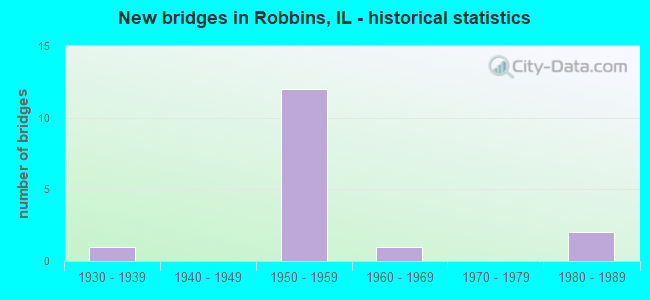
- New bridges - historical statistics
- 11930-1939
- 121950-1959
- 11960-1969
- 21980-1989

- Reconstructed bridges - Historical Statistics
- 11960-1969
- 01970-1979
- 11980-1989


- Bridge Condition - Deck
- 63.6%Good
- 27.3%Satisfactory
- 9.1%Fair

- Bridge Condition - Superstructure
- 9.1%Very good
- 27.3%Good
- 18.2%Satisfactory
- 27.3%Fair
- 18.2%Serious

- Bridge Condition - Substructure
- 45.5%Good
- 27.3%Satisfactory
- 27.3%Fair

- Bridge Condition - Channel
- 50.0%Very good
- 33.3%Satisfactory
- 16.7%Fair

- Bridge Condition - Culverts
- 50.0%Satisfactory
- 50.0%Fair
Find on map >> Show street view
Structure Number: 160748, Location: 1 M N I294 P26 (Lat: 41.649372, Lng: -87.718692), Route carried "on" structure: Other road , Year Built: 1931, Year Reconstructed: 1971, Status: Open, Structure Length: 10.17m (33.37ft), Average Daily Traffic: 21,100 (year 2021), Truck Traffic: 8%, Average Future Daily Traffic: 25,029 (year 2032), Design Load: H 20, Features Intersected: CAL SAG CHANNEL, Facility Carried by Structure: CRAWFORD AVE
Minimum Vertical Clearance: 30+ m (98+ ft), Kilometerpoint: 7.660, Lanes on structure: 4, Base Highway Network: Yes, Owner: County Highway Agency, Approaching Roadway Width: 13.3m (43.6ft), Navigation Control: Yes ( Vertical Clearance: 7.9m (25.9ft), Horizontal Clearance: 60.4m (198.2ft)), Material/Design: Steel, Design/Construction: Truss - Thru, Number Of Spans In Main Unit: 1, Number Of Approach Spans: 3, Length of Maximum Span: 63.1m (207.0ft), Curb or Sidewalk Widths: Left: 1.5m (4.9ft), Right: 1.5m (4.9ft), Curb-To-Curb Width: 13.3m (43.6ft), Out-to-Out Width: 18.7m (61.4ft)
Condition: Deck: Satisfactory, Superstructure: Serious, Substructure: Satisfactory, Channel: Very good, Operating Rating: 38.9 metric tons, Method Used To Determine Operating Rating: Load Factor (LF) rating reported by rating factor (RF) method using MS18 loading, Inventory Rating: 23.3 metric tons, Method Used To Determine Inventory Rating: Load Factor (LF) rating reported by rating factor (RF) method using MS18 loading, Structural Evaluation: High priority of corrective action, Deck Geometry: High priority of replacement, Waterway Adequacy: Superior to present desirable criteria, Approach Roadway Alignment: Equal to present desirable criteria, Length Of Structure Improvement: 11.16m (36.61ft), Designated Inspection Frequency: Every 24 months, Critical Feature Inspection Frequency: Every 12 months, Underwater Inspection Frequency: Every 60 months, Inspection Date: April 2021, Critical Feature Inspection Date: April 2021, Underwater Inspection Date: August 2020, Bridge Improvement Cost: $1,644,000, Roadway Improvement Cost: $164,000, Total Project Cost: $2,466,000, Deck Structure Type: Concrete Cast-file-Place, Wearing Surface/Protective System: Wearing Surface: Latex Concrete
Find on map >> Show street view
Structure Number: 160762, Location: 1.5 M N IL 83 (Lat: 41.651925, Lng: -87.699314), Route carried "on" structure: Other road , Year Built: 1966, Status: Open, Structure Length: 10.62m (34.84ft), Average Daily Traffic: 13,100 (year 2018), Truck Traffic: 5%, Average Future Daily Traffic: 13,905 (year 2032), Design Load: HS 20, Features Intersected: CAL SAG CHANNEL, Facility Carried by Structure: KEDZIE AVE
Minimum Vertical Clearance: 5.33m (17.49ft), Kilometerpoint: 37.915, Lanes on structure: 4, Base Highway Network: Yes, Owner: State Highway Agency, Approaching Roadway Width: 16.2m (53.1ft), Skew: 30 degrees, Navigation Control: Yes ( Vertical Clearance: 7.0m (23.0ft), Horizontal Clearance: 68.6m (225.1ft)), Material/Design: Steel, Design/Construction: Truss - Thru, Number Of Spans In Main Unit: 1, Number Of Approach Spans: 3, Length of Maximum Span: 77.4m (253.9ft), Curb or Sidewalk Widths: Left: 1.5m (4.9ft), Right: 1.5m (4.9ft), Curb-To-Curb Width: 16.2m (53.1ft), Out-to-Out Width: 22.6m (74.1ft)
Condition: Deck: Satisfactory, Superstructure: Serious, Substructure: Fair, Channel: Satisfactory, Operating Rating: 44.1 metric tons, Method Used To Determine Operating Rating: Load Factor (LF) rating reported by rating factor (RF) method using MS18 loading, Inventory Rating: 26.6 metric tons, Method Used To Determine Inventory Rating: Load Factor (LF) rating reported by rating factor (RF) method using MS18 loading, Structural Evaluation: High priority of corrective action, Deck Geometry: Meets minimum limits, Waterway Adequacy: Equal to present desirable criteria, Approach Roadway Alignment: Better than present minimum criteria, Designated Inspection Frequency: Every 12 months, Critical Feature Inspection Frequency: Every 12 months, Inspection Date: September 2021, Critical Feature Inspection Date: September 2021, Deck Structure Type: Concrete Cast-file-Place, Wearing Surface/Protective System: Wearing Surface: Latex Concrete
Find on map >> Show street view
Structure Number: 163218, Location: 0.5M.S.OF 135TH ST. (Lat: 41.637775, Lng: -87.698775), Route carried "on" structure: Other road , Year Built: 1989, Status: Open, Structure Length: 47.55m (156.00ft), Average Daily Traffic: 9,300 (year 2018), Truck Traffic: 6%, Average Future Daily Traffic: 15,656 (year 2032), Design Load: HS 20, Features Intersected: N.E.RR CORP., Facility Carried by Structure: KEDZIE AVE
Minimum Vertical Clearance: 7.09m (23.26ft), Kilometerpoint: 39.508, Lanes on structure: 4, Base Highway Network: Yes, Owner: County Highway Agency, Approaching Roadway Width: 16.5m (54.1ft), Skew: 34 degrees, Material/Design: Steel continuous, Design/Construction: Stringer/Multi-beam, Number Of Spans In Main Unit: 3, Number Of Approach Spans: 16, Length of Maximum Span: 37.0m (121.4ft), Curb or Sidewalk Widths: Left: 1.5m (4.9ft), Right: 1.5m (4.9ft), Curb-To-Curb Width: 16.5m (54.1ft), Out-to-Out Width: 20.7m (67.9ft)
Condition: Deck: Fair, Superstructure: Fair, Substructure: Good, Operating Rating: 59.0 metric tons, Method Used To Determine Operating Rating: Load Factor (LF) rating reported by rating factor (RF) method using MS18 loading, Inventory Rating: 35.3 metric tons, Method Used To Determine Inventory Rating: Load Factor (LF) rating reported by rating factor (RF) method using MS18 loading, Structural Evaluation: Somewhat better than minimum adequacy, Deck Geometry: Meets minimum limits, Underclear: Superior to present desirable criteria, Approach Roadway Alignment: Equal to present desirable criteria, Designated Inspection Frequency: Every 24 months, Inspection Date: March 2021, Deck Structure Type: Concrete Cast-file-Place, Wearing Surface/Protective System: Deck Protection: Epoxy Coated Reinforcing
Find on map >> Show street view
Structure Number: 163225, Location: 0.4M.S.OF 135TH ST. (Lat: 41.640386, Lng: -87.698875), Route carried "on" structure: Other road , Year Built: 1958, Year Reconstructed: 1988, Status: Open, Structure Length: 1.49m (4.89ft), Average Daily Traffic: 9,300 (year 2018), Truck Traffic: 6%, Average Future Daily Traffic: 13,493 (year 2032), Design Load: HS 20, Features Intersected: Midlothian Creek, Facility Carried by Structure: FAU-2831 (Kedzie A
Minimum Vertical Clearance: 30+ m (98+ ft), Kilometerpoint: 39.219, Lanes on structure: 5, Base Highway Network: Yes, Owner: County Highway Agency, Approaching Roadway Width: 20.7m (67.9ft), Skew: 4 degrees, Material/Design: Concrete continuous, Design/Construction: Culvert, Number Of Spans In Main Unit: 3, Length of Maximum Span: 5.1m (16.7ft), Curb or Sidewalk Widths: Left: 1.5m (4.9ft), Right: 1.5m (4.9ft)
Condition: Channel: Satisfactory, Culverts: Fair, Operating Rating: 53.8 metric tons, Method Used To Determine Operating Rating: Assigned rating based on Load Factor Design (LFD) reported by rating factor (RF) using MS18 loading, Inventory Rating: 32.4 metric tons, Method Used To Determine Inventory Rating: Assigned rating based on Load Factor Design (LFD) reported by rating factor (RF) using MS18 loading, Structural Evaluation: Somewhat better than minimum adequacy, Waterway Adequacy: Equal to present desirable criteria, Approach Roadway Alignment: Equal to present desirable criteria, Designated Inspection Frequency: Every 24 months, Inspection Date: June 2021, Deck Structure Type: Concrete Cast-file-Place
Find on map >> Show street view
Structure Number: 163244, Location: 0.09M.E.OF KEDZIE AV (Lat: 41.644186, Lng: -87.698325), Route carried "on" structure: City street , Year Built: 1980, Status: Open, Structure Length: 1.85m (6.07ft), Average Daily Traffic: 200 (year 2018), Truck Traffic: 10%, Average Future Daily Traffic: 1,039 (year 2032), Design Load: HS 20, Features Intersected: MIDLOTHIAN CREEK, Facility Carried by Structure: 137TH ST.
Minimum Vertical Clearance: 30+ m (98+ ft), Kilometerpoint: 0.048, Lanes on structure: 4, Owner: County Highway Agency, Approaching Roadway Width: 15.8m (51.8ft), Skew: 3 degrees, Material/Design: Concrete, Design/Construction: Culvert, Number Of Spans In Main Unit: 2, Length of Maximum Span: 3.7m (12.1ft)
Condition: Channel: Fair, Culverts: Satisfactory, Operating Rating: 56.7 metric tons, Method Used To Determine Operating Rating: Load Factor (LF) rating reported by rating factor (RF) method using MS18 loading, Inventory Rating: 34.0 metric tons, Method Used To Determine Inventory Rating: Load Factor (LF) rating reported by rating factor (RF) method using MS18 loading, Structural Evaluation: Equal to present minimum criteria, Waterway Adequacy: Equal to present desirable criteria, Approach Roadway Alignment: Equal to present desirable criteria, Designated Inspection Frequency: Every 24 months, Inspection Date: August 2020, Deck Structure Type: Concrete Cast-file-Place
Find on map >> Show street view
Structure Number: 169846, Location: 1 M SE ILL 50 P26 (Lat: 41.650781, Lng: -87.724811), Route carried "on" structure: Interstate 294, Year Built: 1958, Status: Open, Structure Length: 17.80m (58.40ft), Average Daily Traffic: 61,600 (year 2020), Truck Traffic: 16%, Average Future Daily Traffic: 45,835 (year 2032), Features Intersected: CAL SAG CANAL
Minimum Vertical Clearance: 30+ m (98+ ft), Kilometerpoint: 67.542, Lanes on structure: 2, Base Highway Network: Yes, Toll: On toll road, Owner: State Toll Authority, Approaching Roadway Width: 12.2m (40.0ft), Navigation Control: Yes ( Vertical Clearance: 12.2m (40.0ft), Horizontal Clearance: 68.6m (225.1ft)), Material/Design: Steel, Number Of Spans In Main Unit: 3, Length of Maximum Span: 91.4m (299.9ft), Curb-To-Curb Width: 12.8m (42.0ft), Out-to-Out Width: 14.1m (46.3ft)
Condition: Deck: Good, Superstructure: Very good, Substructure: Fair, Channel: Very good, Operating Rating: 50.9 metric tons, Method Used To Determine Operating Rating: Load Factor (LF) rating reported by rating factor (RF) method using MS18 loading, Inventory Rating: 30.5 metric tons, Method Used To Determine Inventory Rating: Load Factor (LF) rating reported by rating factor (RF) method using MS18 loading, Structural Evaluation: Somewhat better than minimum adequacy, Deck Geometry: Equal to present desirable criteria, Waterway Adequacy: Superior to present desirable criteria, Approach Roadway Alignment: Equal to present desirable criteria, Designated Inspection Frequency: Every 24 months, Underwater Inspection Frequency: Every 60 months, Inspection Date: June 2020, Underwater Inspection Date: April 2018, Deck Structure Type: Concrete Cast-file-Place, Wearing Surface/Protective System: Wearing Surface: Bituminous
Find on map >> Show street view
Structure Number: 169847, Location: 1 M SE ILL 50 P26 (Lat: 41.650656, Lng: -87.724750), Route carried "on" structure: Interstate 294, Year Built: 1958, Status: Open, Structure Length: 17.80m (58.40ft), Average Daily Traffic: 61,600 (year 2020), Truck Traffic: 16%, Average Future Daily Traffic: 45,835 (year 2032), Features Intersected: CAL SAG CANAL
Minimum Vertical Clearance: 30+ m (98+ ft), Kilometerpoint: 67.558, Lanes on structure: 2, Base Highway Network: Yes, Toll: On toll road, Owner: State Toll Authority, Approaching Roadway Width: 12.2m (40.0ft), Navigation Control: Yes ( Vertical Clearance: 12.2m (40.0ft), Horizontal Clearance: 68.6m (225.1ft)), Material/Design: Steel, Number Of Spans In Main Unit: 3, Length of Maximum Span: 91.4m (299.9ft), Curb-To-Curb Width: 12.8m (42.0ft), Out-to-Out Width: 14.1m (46.3ft)
Condition: Deck: Satisfactory, Superstructure: Good, Substructure: Satisfactory, Channel: Very good, Operating Rating: 53.1 metric tons, Method Used To Determine Operating Rating: Load Factor (LF) rating reported by rating factor (RF) method using MS18 loading, Inventory Rating: 31.8 metric tons, Method Used To Determine Inventory Rating: Load Factor (LF) rating reported by rating factor (RF) method using MS18 loading, Structural Evaluation: Equal to present minimum criteria, Deck Geometry: Equal to present desirable criteria, Waterway Adequacy: Superior to present desirable criteria, Approach Roadway Alignment: Equal to present desirable criteria, Designated Inspection Frequency: Every 24 months, Underwater Inspection Frequency: Every 60 months, Inspection Date: June 2020, Underwater Inspection Date: April 2018, Deck Structure Type: Concrete Cast-file-Place, Wearing Surface/Protective System: Wearing Surface: Bituminous
Find on map >> Show street view
Structure Number: 169848, Location: 1.3 M SE ILL 50 P26 (Lat: 41.647531, Lng: -87.723186), Route carried "on" structure: Interstate 294, Year Built: 1958, Status: Open, Structure Length: 2.29m (7.51ft), Average Daily Traffic: 61,600 (year 2020), Truck Traffic: 16%, Average Future Daily Traffic: 45,835 (year 2032), Features Intersected: 135TH ST
Minimum Vertical Clearance: 30+ m (98+ ft), Kilometerpoint: 67.961, Lanes on structure: 2, Lanes under structure: 2, Base Highway Network: Yes, Toll: On toll road, Owner: State Toll Authority, Approaching Roadway Width: 12.2m (40.0ft), Skew: 1 degrees, Material/Design: Prestressed concrete, Design/Construction: Stringer/Multi-beam, Number Of Spans In Main Unit: 1, Length of Maximum Span: 21.6m (70.9ft), Curb-To-Curb Width: 10.5m (34.4ft), Out-to-Out Width: 18.6m (61.0ft)
Condition: Deck: Good, Superstructure: Satisfactory, Substructure: Fair, Operating Rating: 54.1 metric tons, Method Used To Determine Operating Rating: Load Factor (LF) rating reported by rating factor (RF) method using MS18 loading, Inventory Rating: 32.4 metric tons, Method Used To Determine Inventory Rating: Load Factor (LF) rating reported by rating factor (RF) method using MS18 loading, Structural Evaluation: Somewhat better than minimum adequacy, Deck Geometry: Meets minimum limits, Underclear: Meets minimum limits, Approach Roadway Alignment: Equal to present desirable criteria, Designated Inspection Frequency: Every 24 months, Inspection Date: April 2020, Deck Structure Type: Concrete Cast-file-Place, Wearing Surface/Protective System: Wearing Surface: Bituminous, Membrane: Built-up
Find on map >> Show street view
Structure Number: 169849, Location: 1.3 M SE ILL 50 P26 (Lat: 41.647406, Lng: -87.723122), Route carried "on" structure: Interstate 294, Year Built: 1958, Status: Open, Structure Length: 2.29m (7.51ft), Average Daily Traffic: 61,600 (year 2020), Truck Traffic: 16%, Average Future Daily Traffic: 45,835 (year 2032), Features Intersected: 135TH ST
Minimum Vertical Clearance: 30+ m (98+ ft), Kilometerpoint: 67.977, Lanes on structure: 2, Lanes under structure: 2, Base Highway Network: Yes, Toll: On toll road, Owner: State Toll Authority, Approaching Roadway Width: 12.2m (40.0ft), Skew: 1 degrees, Material/Design: Prestressed concrete, Design/Construction: Stringer/Multi-beam, Number Of Spans In Main Unit: 1, Length of Maximum Span: 21.6m (70.9ft), Curb-To-Curb Width: 10.5m (34.4ft), Out-to-Out Width: 18.6m (61.0ft)
Condition: Deck: Good, Superstructure: Satisfactory, Substructure: Satisfactory, Operating Rating: 84.2 metric tons, Method Used To Determine Operating Rating: Load Factor (LF) rating reported by rating factor (RF) method using MS18 loading, Inventory Rating: 50.5 metric tons, Method Used To Determine Inventory Rating: Load Factor (LF) rating reported by rating factor (RF) method using MS18 loading, Structural Evaluation: Equal to present minimum criteria, Deck Geometry: Meets minimum limits, Underclear: Meets minimum limits, Approach Roadway Alignment: Equal to present desirable criteria, Length Of Structure Improvement: 2.29m (7.51ft), Designated Inspection Frequency: Every 24 months, Inspection Date: April 2020, Bridge Improvement Cost: $288,000, Roadway Improvement Cost: $29,000, Total Project Cost: $432,000, Deck Structure Type: Concrete Cast-file-Place, Wearing Surface/Protective System: Wearing Surface: Bituminous, Membrane: Built-up
Find on map >> Show street view
Structure Number: 16985, Location: 1.7 M SE 127ST P3 (Lat: 41.641494, Lng: -87.720169), Route carried "on" structure: Interstate 294, Year Built: 1958, Status: Open, Structure Length: 2.10m (6.89ft), Average Daily Traffic: 61,600 (year 2020), Truck Traffic: 16%, Average Future Daily Traffic: 45,835 (year 2032), Features Intersected: MIDLOTHIAN TURNPIKE
Minimum Vertical Clearance: 30+ m (98+ ft), Kilometerpoint: 68.669, Lanes on structure: 2, Lanes under structure: 2, Base Highway Network: Yes, Toll: On toll road, Owner: State Toll Authority, Approaching Roadway Width: 12.2m (40.0ft), Material/Design: Prestressed concrete, Design/Construction: Stringer/Multi-beam, Number Of Spans In Main Unit: 1, Length of Maximum Span: 20.1m (65.9ft), Curb-To-Curb Width: 10.5m (34.4ft), Out-to-Out Width: 18.6m (61.0ft)
Condition: Deck: Good, Superstructure: Good, Substructure: Good, Operating Rating: 93.6 metric tons, Method Used To Determine Operating Rating: Load Factor (LF) rating reported by rating factor (RF) method using MS18 loading, Inventory Rating: 56.1 metric tons, Method Used To Determine Inventory Rating: Load Factor (LF) rating reported by rating factor (RF) method using MS18 loading, Structural Evaluation: Better than present minimum criteria, Deck Geometry: Meets minimum limits, Underclear: Meets minimum limits, Approach Roadway Alignment: Equal to present desirable criteria, Length Of Structure Improvement: 2.10m (6.89ft), Designated Inspection Frequency: Every 24 months, Inspection Date: May 2019, Bridge Improvement Cost: $222,000, Roadway Improvement Cost: $22,000, Total Project Cost: $333,000, Deck Structure Type: Concrete Cast-file-Place, Wearing Surface/Protective System: Wearing Surface: Bituminous, Membrane: Built-up
Find on map >> Show street view
Structure Number: 169851, Location: 1.7 M SE ILL 50 P3 (Lat: 41.641431, Lng: -87.720136), Route carried "on" structure: Interstate 294, Year Built: 1958, Status: Open, Structure Length: 2.10m (6.89ft), Average Daily Traffic: 61,600 (year 2020), Truck Traffic: 16%, Average Future Daily Traffic: 45,835 (year 2032), Features Intersected: MIDLOTHIAN TURNPIKE
Minimum Vertical Clearance: 30+ m (98+ ft), Kilometerpoint: 68.685, Lanes on structure: 2, Lanes under structure: 2, Base Highway Network: Yes, Toll: On toll road, Owner: State Toll Authority, Approaching Roadway Width: 12.2m (40.0ft), Material/Design: Prestressed concrete, Design/Construction: Stringer/Multi-beam, Number Of Spans In Main Unit: 1, Length of Maximum Span: 20.1m (65.9ft), Curb-To-Curb Width: 10.5m (34.4ft), Out-to-Out Width: 18.6m (61.0ft)
Condition: Deck: Good, Superstructure: Good, Substructure: Good, Operating Rating: 75.2 metric tons, Method Used To Determine Operating Rating: Load Factor (LF) rating reported by rating factor (RF) method using MS18 loading, Inventory Rating: 45.0 metric tons, Method Used To Determine Inventory Rating: Load Factor (LF) rating reported by rating factor (RF) method using MS18 loading, Structural Evaluation: Better than present minimum criteria, Deck Geometry: Meets minimum limits, Underclear: Meets minimum limits, Approach Roadway Alignment: Equal to present desirable criteria, Length Of Structure Improvement: 2.10m (6.89ft), Designated Inspection Frequency: Every 24 months, Inspection Date: May 2019, Bridge Improvement Cost: $222,000, Roadway Improvement Cost: $22,000, Total Project Cost: $333,000, Deck Structure Type: Concrete Cast-file-Place, Wearing Surface/Protective System: Wearing Surface: Bituminous, Membrane: Built-up
Find on map >> Show street view
Structure Number: 169854, Location: 1.5 M NW IL 83 P3 (Lat: 41.634042, Lng: -87.712839), Route carried "on" structure: Interstate 294, Year Built: 1958, Status: Open, Structure Length: 2.13m (6.99ft), Average Daily Traffic: 61,600 (year 2020), Truck Traffic: 16%, Average Future Daily Traffic: 45,835 (year 2032), Features Intersected: REXFORD RD
Minimum Vertical Clearance: 30+ m (98+ ft), Kilometerpoint: 69.779, Lanes on structure: 2, Lanes under structure: 2, Base Highway Network: Yes, Toll: On toll road, Owner: State Toll Authority, Approaching Roadway Width: 12.2m (40.0ft), Material/Design: Prestressed concrete, Design/Construction: Stringer/Multi-beam, Number Of Spans In Main Unit: 1, Length of Maximum Span: 20.4m (66.9ft), Curb-To-Curb Width: 10.5m (34.4ft), Out-to-Out Width: 18.6m (61.0ft)
Condition: Deck: Good, Superstructure: Fair, Substructure: Good, Operating Rating: 79.7 metric tons, Method Used To Determine Operating Rating: Load Factor (LF) rating reported by rating factor (RF) method using MS18 loading, Inventory Rating: 47.6 metric tons, Method Used To Determine Inventory Rating: Load Factor (LF) rating reported by rating factor (RF) method using MS18 loading, Structural Evaluation: Somewhat better than minimum adequacy, Deck Geometry: Meets minimum limits, Underclear: Meets minimum limits, Approach Roadway Alignment: Equal to present desirable criteria, Designated Inspection Frequency: Every 24 months, Inspection Date: April 2020, Deck Structure Type: Concrete Cast-file-Place, Wearing Surface/Protective System: Wearing Surface: Bituminous, Membrane: Built-up
Find on map >> Show street view
Structure Number: 169855, Location: 1.5 M NW IL 83 P3 (Lat: 41.633967, Lng: -87.712683), Route carried "on" structure: Interstate 294, Year Built: 1958, Status: Open, Structure Length: 2.13m (6.99ft), Average Daily Traffic: 61,600 (year 2020), Truck Traffic: 16%, Average Future Daily Traffic: 45,835 (year 2032), Features Intersected: REXFORD RD
Minimum Vertical Clearance: 30+ m (98+ ft), Kilometerpoint: 69.795, Lanes on structure: 2, Lanes under structure: 4, Base Highway Network: Yes, Toll: On toll road, Owner: State Toll Authority, Approaching Roadway Width: 12.2m (40.0ft), Material/Design: Prestressed concrete, Design/Construction: Stringer/Multi-beam, Number Of Spans In Main Unit: 1, Length of Maximum Span: 20.4m (66.9ft), Curb-To-Curb Width: 10.5m (34.4ft), Out-to-Out Width: 18.6m (61.0ft)
Condition: Deck: Good, Superstructure: Fair, Substructure: Good, Operating Rating: 57.0 metric tons, Method Used To Determine Operating Rating: Load Factor (LF) rating reported by rating factor (RF) method using MS18 loading, Inventory Rating: 34.0 metric tons, Method Used To Determine Inventory Rating: Load Factor (LF) rating reported by rating factor (RF) method using MS18 loading, Structural Evaluation: Somewhat better than minimum adequacy, Deck Geometry: Meets minimum limits, Underclear: Meets minimum limits, Approach Roadway Alignment: Equal to present desirable criteria, Length Of Structure Improvement: 2.13m (6.99ft), Designated Inspection Frequency: Every 24 months, Inspection Date: April 2020, Bridge Improvement Cost: $225,000, Roadway Improvement Cost: $23,000, Total Project Cost: $338,000, Deck Structure Type: Concrete Cast-file-Place, Wearing Surface/Protective System: Wearing Surface: Bituminous, Membrane: Built-up
Find on map >> Show street view
Structure Number: 169848, Location: 1.3 M SE ILL 50 P26 (Lat: 41.647411, Lng: -87.722764), Route carried "under" structure: Other road , Year Built: 1958, Structure Length: 0. m, Average Daily Traffic: 11,300 (year 2021), Truck Traffic: 3%, Features Intersected: 135TH ST, Facility Carried by Structure: I-294 SB
Minimum Vertical Clearance: 4.39m (14.40ft), Kilometerpoint: 10.959, Lanes on structure: 2, Lanes under structure: 2, Toll: On toll road, Material/Design: Prestressed concrete, Design/Construction: Stringer/Multi-beam, Length of Maximum Span: 21.6m (70.9ft)
Find on map >> Show street view
Structure Number: 169849, Location: 1.3 M SE ILL 50 P26 (Lat: 41.647406, Lng: -87.723122), Route carried "under" structure: Other road , Year Built: 1958, Structure Length: 0. m, Average Daily Traffic: 11,300 (year 2021), Truck Traffic: 3%, Features Intersected: 135TH ST, Facility Carried by Structure: I-294 NB
Minimum Vertical Clearance: 4.55m (14.93ft), Kilometerpoint: 10.943, Lanes on structure: 2, Lanes under structure: 2, Toll: On toll road, Material/Design: Prestressed concrete, Design/Construction: Stringer/Multi-beam, Length of Maximum Span: 21.6m (70.9ft)
Find on map >> Show street view
Structure Number: 169855, Location: 1.5 M NW IL 83 P3 (Lat: 41.634061, Lng: -87.712331), Route carried "under" structure: Other road , Year Built: 1958, Structure Length: 0. m, Average Daily Traffic: 2,400 (year 2018), Truck Traffic: 8%, Features Intersected: REXFORD RD, Facility Carried by Structure: I-294 NB
Minimum Vertical Clearance: 4.42m (14.50ft), Kilometerpoint: 0.547, Lanes on structure: 2, Lanes under structure: 4, Toll: On toll road, Material/Design: Prestressed concrete, Design/Construction: Stringer/Multi-beam, Length of Maximum Span: 20.4m (66.9ft)