Bridge Statistics for Roaring Spring, Pennsylvania (PA)
Condition, Traffic, Stress, Structural Evaluation, Project Costs
- National Bridge Inventory (NBI) Statistics
- 10Number of bridges
- 69ft / 20.7mTotal length
- $2,123,000Total costs
- 44,082Total average daily traffic
- 3,612Total average daily truck traffic
- 57,949Total future (year 2032) average daily traffic
- National Bridge Inventory (NBI) Registered Bridges for Roaring Spring
- No street view available for this location
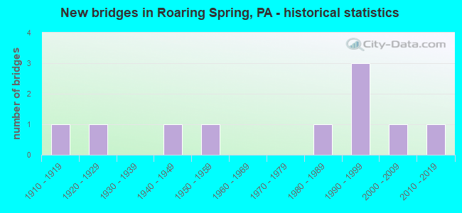
- New bridges - historical statistics
- 11910-1919
- 11920-1929
- 11940-1949
- 11950-1959
- 11980-1989
- 31990-1999
- 12000-2009
- 12010-2019

- Reconstructed bridges - Historical Statistics
- 11980-1989
- 01990-1999
- 32000-2009
- 32010-2019


- Bridge Condition - Deck
- 22.2%Very good
- 66.7%Good
- 11.1%Fair

- Bridge Condition - Superstructure
- 33.3%Very good
- 44.4%Good
- 22.2%Fair

- Bridge Condition - Substructure
- 11.1%Very good
- 33.3%Good
- 55.6%Satisfactory

- Bridge Condition - Channel
- 60.0%Good
- 20.0%Satisfactory
- 20.0%Fair
Find on map >> Show street view
Structure Number: 5547, Location: .25 MI.N.ROARING SPRING (Lat: 40.343569, Lng: -78.403881), Route carried "on" structure: State highway 36, Year Built: 1997, Year Reconstructed: 2015, Status: Open, Structure Length: 1.43m (4.69ft), Average Daily Traffic: 16,294 (year 2021), Truck Traffic: 9%, Average Future Daily Traffic: 20,113 (year 2032), Design Load: HS 25 or greater, Features Intersected: HALTER CREEK
Minimum Vertical Clearance: 30+ m (98+ ft), Kilometerpoint: 8.764, Lanes on structure: 3, Owner: State Highway Agency, Approaching Roadway Width: 17.1m (56.1ft), Material/Design: Prestressed concrete, Design/Construction: Box Beam or Girders - Single/Spread, Number Of Spans In Main Unit: 1, Length of Maximum Span: 14.0m (45.9ft), Curb or Sidewalk Widths: Left: 0.2m (0.7ft), Right: 2.1m (6.9ft), Curb-To-Curb Width: 16.5m (54.1ft), Out-to-Out Width: 19.6m (64.3ft)
Condition: Deck: Very good, Superstructure: Very good, Substructure: Very good, Channel: Satisfactory, Operating Rating: 70.8 metric tons, Method Used To Determine Operating Rating: Load Factor (LF), Inventory Rating: 42.6 metric tons, Method Used To Determine Inventory Rating: Load Factor (LF), Structural Evaluation: Equal to present desirable criteria, Deck Geometry: Better than present minimum criteria, Waterway Adequacy: Superior to present desirable criteria, Approach Roadway Alignment: Equal to present desirable criteria, Length Of Structure Improvement: 2.10m (6.89ft), Designated Inspection Frequency: Every 48 months, Inspection Date: July 2018, Deck Structure Type: Concrete Cast-file-Place, Wearing Surface/Protective System: Wearing Surface: Epoxy Overlay, Deck Protection: Epoxy Coated Reinforcing
Find on map >> Show street view
Structure Number: 5549, Location: 1 MI.N.OF ROARING SPRING (Lat: 40.352394, Lng: -78.407244), Route carried "on" structure: State highway 36, Year Built: 1997, Year Reconstructed: 2015, Status: Open, Structure Length: 5.18m (16.99ft), Average Daily Traffic: 17,747 (year 2021), Truck Traffic: 10%, Average Future Daily Traffic: 24,318 (year 2032), Design Load: HS 25 or greater, Features Intersected: HALTER CREEK
Minimum Vertical Clearance: 30+ m (98+ ft), Kilometerpoint: 9.785, Lanes on structure: 3, Owner: State Highway Agency, Approaching Roadway Width: 14.9m (48.9ft), Skew: 5 degrees, Material/Design: Prestressed concrete, Design/Construction: Stringer/Multi-beam, Number Of Spans In Main Unit: 2, Length of Maximum Span: 25.0m (82.0ft), Curb or Sidewalk Widths: Left: 0.2m (0.7ft), Right: 0.2m (0.7ft), Curb-To-Curb Width: 18.7m (61.4ft), Out-to-Out Width: 19.7m (64.6ft)
Condition: Deck: Good, Superstructure: Good, Substructure: Satisfactory, Channel: Fair, Inventory Rating: 48.1 metric tons, Method Used To Determine Inventory Rating: Load Factor (LF), Structural Evaluation: Equal to present minimum criteria, Deck Geometry: Superior to present desirable criteria, Waterway Adequacy: Equal to present minimum criteria, Approach Roadway Alignment: Equal to present desirable criteria, Length Of Structure Improvement: 6.20m (20.34ft), Designated Inspection Frequency: Every 48 months, Inspection Date: July 2018, Deck Structure Type: Concrete Cast-file-Place, Wearing Surface/Protective System: Wearing Surface: Epoxy Overlay, Deck Protection: Epoxy Coated Reinforcing
Find on map >> Show street view
Structure Number: 5727, Location: 36 FT. EAST OF SR 0036 (Lat: 40.352081, Lng: -78.406331), Route carried "on" structure: State highway , Year Built: 1996, Status: Open, Structure Length: 3.99m (13.09ft), Average Daily Traffic: 431 (year 2020), Truck Traffic: 3%, Average Future Daily Traffic: 379 (year 2032), Design Load: HS 25 or greater, Features Intersected: HALTER CREEK, Facility Carried by Structure: SR 2008
Minimum Vertical Clearance: 30+ m (98+ ft), Kilometerpoint: 0.000, Lanes on structure: 2, Owner: State Highway Agency, Approaching Roadway Width: 11.0m (36.1ft), Skew: 1 degrees, Material/Design: Prestressed concrete, Design/Construction: Box Beam or Girders - Single/Spread, Number Of Spans In Main Unit: 2, Length of Maximum Span: 19.5m (64.0ft), Curb or Sidewalk Widths: Left: 0.2m (0.7ft), Right: 0.2m (0.7ft), Curb-To-Curb Width: 11.0m (36.1ft), Out-to-Out Width: 12.1m (39.7ft)
Condition: Deck: Good, Superstructure: Good, Substructure: Good, Channel: Good, Operating Rating: 78.9 metric tons, Method Used To Determine Operating Rating: Load Factor (LF), Inventory Rating: 43.5 metric tons, Method Used To Determine Inventory Rating: Load Factor (LF), Structural Evaluation: Better than present minimum criteria, Deck Geometry: Better than present minimum criteria, Waterway Adequacy: Equal to present desirable criteria, Approach Roadway Alignment: Equal to present desirable criteria, Length Of Structure Improvement: 4.80m (15.75ft), Designated Inspection Frequency: Every 48 months, Inspection Date: July 2018, Deck Structure Type: Concrete Cast-file-Place, Wearing Surface/Protective System: Wearing Surface: Monolithic Concrete, Deck Protection: Epoxy Coated Reinforcing
Find on map >> Show street view
Structure Number: 5729, Location: 1.5 MI.NE.ROARING SPRING (Lat: 40.353464, Lng: -78.383572), Route carried "on" structure: State highway , Year Built: 1940, Year Reconstructed: 1993, Status: Open, Structure Length: 1.43m (4.69ft), Average Daily Traffic: 431 (year 2020), Truck Traffic: 3%, Average Future Daily Traffic: 379 (year 2032), Design Load: HS 25 or greater, Features Intersected: PLUM CREEK, Facility Carried by Structure: SR 2008
Minimum Vertical Clearance: 30+ m (98+ ft), Kilometerpoint: 3.182, Lanes on structure: 2, Owner: State Highway Agency, Approaching Roadway Width: 6.1m (20.0ft), Skew: 3 degrees, Material/Design: Steel, Design/Construction: Stringer/Multi-beam, Number Of Spans In Main Unit: 1, Length of Maximum Span: 14.0m (45.9ft), Curb-To-Curb Width: 7.3m (24.0ft), Out-to-Out Width: 7.8m (25.6ft)
Condition: Deck: Very good, Superstructure: Very good, Substructure: Satisfactory, Channel: Good, Inventory Rating: 67.1 metric tons, Method Used To Determine Inventory Rating: Load Factor (LF), Structural Evaluation: Equal to present minimum criteria, Deck Geometry: Meets minimum limits, Waterway Adequacy: Equal to present desirable criteria, Approach Roadway Alignment: Better than present minimum criteria, Length Of Structure Improvement: 2.10m (6.89ft), Designated Inspection Frequency: Every 24 months, Inspection Date: June 2020, Deck Structure Type: Concrete Cast-file-Place, Wearing Surface/Protective System: Wearing Surface: Monolithic Concrete, Deck Protection: Epoxy Coated Reinforcing
Find on map >> Show street view
Structure Number: 573, Location: SHARPSBURG (Lat: 40.335697, Lng: -78.374214), Route carried "on" structure: City street , Year Built: 1915, Year Reconstructed: 2014, Status: Open, Structure Length: 1.31m (4.30ft), Average Daily Traffic: 376 (year 2020), Truck Traffic: 3%, Average Future Daily Traffic: 379 (year 2040), Design Load: H 15, Features Intersected: PLUM CREEK, Facility Carried by Structure: T-614, Plum Crk Rd
Minimum Vertical Clearance: 30+ m (98+ ft), Kilometerpoint: 0.000, Lanes on structure: 2, Owner: Town or Township Highway Agency, Approaching Roadway Width: 5.8m (19.0ft), Skew: 2 degrees, Material/Design: Concrete, Number Of Spans In Main Unit: 1, Length of Maximum Span: 12.5m (41.0ft), Curb-To-Curb Width: 6.1m (20.0ft), Out-to-Out Width: 6.9m (22.6ft)
Condition: Deck: Fair, Superstructure: Good, Substructure: Good, Channel: Good, Operating Rating: 74.4 metric tons, Method Used To Determine Operating Rating: Field evaluation and documented engineering judgment, Inventory Rating: 44.5 metric tons, Method Used To Determine Inventory Rating: Field evaluation and documented engineering judgment, Structural Evaluation: Better than present minimum criteria, Deck Geometry: Meets minimum limits, Waterway Adequacy: Equal to present desirable criteria, Approach Roadway Alignment: Equal to present desirable criteria, Length Of Structure Improvement: 1.60m (5.25ft), Designated Inspection Frequency: Every 24 months, Inspection Date: November 2020, Bridge Improvement Cost: $54,000, Roadway Improvement Cost: $264,000, Total Project Cost: $729,000, Deck Structure Type: Concrete Cast-file-Place, Wearing Surface/Protective System: Wearing Surface: Monolithic Concrete, Deck Protection: Epoxy Coated Reinforcing
Find on map >> Show street view
Structure Number: 5955, Location: .5 MI.W.OF ROARING SPRING (Lat: 40.331819, Lng: -78.407811), Route carried "on" structure: City street , Year Built: 1922, Year Reconstructed: 2005, Status: Open, Structure Length: 1.16m (3.81ft), Average Daily Traffic: 87 (year 2020), Average Future Daily Traffic: 65 (year 2040), Design Load: HS 20, Features Intersected: HALTER CREEK, Facility Carried by Structure: T333,HALTER CRK RD
Minimum Vertical Clearance: 30+ m (98+ ft), Kilometerpoint: 0.000, Lanes on structure: 2, Owner: Town or Township Highway Agency, Approaching Roadway Width: 4.9m (16.1ft), Skew: 3 degrees, Material/Design: Prestressed concrete, Design/Construction: Tee Beam, Number Of Spans In Main Unit: 1, Length of Maximum Span: 10.4m (34.1ft), Curb-To-Curb Width: 5.0m (16.4ft), Out-to-Out Width: 5.5m (18.0ft)
Condition: Deck: Good, Superstructure: Good, Substructure: Satisfactory, Channel: Good, Operating Rating: 53.5 metric tons, Method Used To Determine Operating Rating: Load Factor (LF), Inventory Rating: 37.2 metric tons, Method Used To Determine Inventory Rating: Load Factor (LF), Structural Evaluation: Equal to present minimum criteria, Deck Geometry: High priority of corrective action, Waterway Adequacy: Better than present minimum criteria, Approach Roadway Alignment: Equal to present desirable criteria, Length Of Structure Improvement: 1.20m (3.94ft), Designated Inspection Frequency: Every 24 months, Inspection Date: November 2020, Bridge Improvement Cost: $47,000, Roadway Improvement Cost: $261,000, Total Project Cost: $629,000, Wearing Surface/Protective System: Wearing Surface: Monolithic Concrete
Find on map >> Show street view
Structure Number: 5957, Location: 1 MI.SW.OF ROARING SPRING (Lat: 40.324322, Lng: -78.410492), Route carried "on" structure: City street , Year Built: 1956, Year Reconstructed: 2016, Status: Open, Structure Length: 1.43m (4.69ft), Average Daily Traffic: 231 (year 2021), Truck Traffic: 1%, Average Future Daily Traffic: 289 (year 2041), Design Load: HS 20, Features Intersected: Halter Creek, Facility Carried by Structure: T351, Heuston Road
Minimum Vertical Clearance: 30+ m (98+ ft), Kilometerpoint: 0.000, Lanes on structure: 2, Owner: County Highway Agency, Approaching Roadway Width: 4.9m (16.1ft), Material/Design: Prestressed concrete, Design/Construction: Box Beam or Girders - Multiple, Number Of Spans In Main Unit: 1, Length of Maximum Span: 12.8m (42.0ft), Curb-To-Curb Width: 6.1m (20.0ft), Out-to-Out Width: 6.5m (21.3ft)
Condition: Deck: Good, Superstructure: Fair, Substructure: Satisfactory, Channel: Fair, Operating Rating: 74.4 metric tons, Method Used To Determine Operating Rating: Load Factor (LF), Inventory Rating: 37.2 metric tons, Method Used To Determine Inventory Rating: Load Factor (LF), Structural Evaluation: Somewhat better than minimum adequacy, Deck Geometry: Meets minimum limits, Waterway Adequacy: Superior to present desirable criteria, Approach Roadway Alignment: Equal to present desirable criteria, Length Of Structure Improvement: 1.80m (5.91ft), Designated Inspection Frequency: Every 24 months, Inspection Date: July 2021, Bridge Improvement Cost: $57,000, Roadway Improvement Cost: $264,000, Total Project Cost: $765,000, Wearing Surface/Protective System: Wearing Surface: Epoxy Overlay, Deck Protection: Epoxy Coated Reinforcing
Find on map >> Show street view
Structure Number: 5959, Location: 1 MI.N.OF ROARING SPRING (Lat: 40.354336, Lng: -78.397253), Route carried "on" structure: City street , Year Built: 1989, Year Reconstructed: 2014, Status: Open, Structure Length: 2.04m (6.69ft), Average Daily Traffic: 77 (year 2020), Truck Traffic: 1%, Average Future Daily Traffic: 135 (year 2040), Design Load: HS 25 or greater, Features Intersected: PLUM CREEK, Facility Carried by Structure: T-365,Weitzel Hill
Minimum Vertical Clearance: 30+ m (98+ ft), Kilometerpoint: 0.000, Lanes on structure: 2, Owner: County Highway Agency, Approaching Roadway Width: 6.1m (20.0ft), Skew: 4 degrees, Material/Design: Prestressed concrete, Design/Construction: Box Beam or Girders - Multiple, Number Of Spans In Main Unit: 1, Length of Maximum Span: 19.8m (65.0ft), Curb or Sidewalk Widths: Left: 0.2m (0.7ft), Right: 0.2m (0.7ft), Curb-To-Curb Width: 8.7m (28.5ft), Out-to-Out Width: 9.8m (32.2ft)
Condition: Deck: Good, Superstructure: Fair, Substructure: Satisfactory, Channel: Satisfactory, Operating Rating: 78.0 metric tons, Method Used To Determine Operating Rating: Load Factor (LF), Inventory Rating: 29.0 metric tons, Method Used To Determine Inventory Rating: Load Factor (LF), Structural Evaluation: Somewhat better than minimum adequacy, Deck Geometry: Better than present minimum criteria, Waterway Adequacy: Equal to present desirable criteria, Approach Roadway Alignment: Better than present minimum criteria, Length Of Structure Improvement: 2.70m (8.86ft), Designated Inspection Frequency: Every 24 months, Inspection Date: December 2020, Deck Structure Type: Concrete Cast-file-Place, Wearing Surface/Protective System: Wearing Surface: Monolithic Concrete, Deck Protection: Epoxy Coated Reinforcing
Find on map >> Show street view
Structure Number: 40833, Location: 1.00 MILE EAST FROM PA 36 (Lat: 40.334203, Lng: -78.372508), Route carried "on" structure: State highway 164, Year Built: 2000, Status: Open, Structure Length: 2.10m (6.89ft), Average Daily Traffic: 7,868 (year 2020), Truck Traffic: 4%, Average Future Daily Traffic: 11,187 (year 2032), Design Load: HL 93, Features Intersected: PLUM CREEK
Minimum Vertical Clearance: 30+ m (98+ ft), Kilometerpoint: 18.641, Lanes on structure: 2, Owner: State Highway Agency, Approaching Roadway Width: 14.0m (45.9ft), Skew: 3 degrees, Material/Design: Prestressed concrete, Design/Construction: Box Beam or Girders - Multiple, Number Of Spans In Main Unit: 1, Length of Maximum Span: 20.1m (65.9ft), Curb or Sidewalk Widths: Left: 0.2m (0.7ft), Right: 0.2m (0.7ft), Curb-To-Curb Width: 13.9m (45.6ft), Out-to-Out Width: 14.7m (48.2ft)
Condition: Deck: Good, Superstructure: Very good, Substructure: Good, Channel: Good, Operating Rating: 63.5 metric tons, Method Used To Determine Operating Rating: Load and Resistance Factor (LRFR), Inventory Rating: 42.6 metric tons, Method Used To Determine Inventory Rating: Load and Resistance Factor (LRFR), Structural Evaluation: Better than present minimum criteria, Deck Geometry: Superior to present desirable criteria, Waterway Adequacy: Equal to present minimum criteria, Approach Roadway Alignment: Equal to present desirable criteria, Length Of Structure Improvement: 2.80m (9.19ft), Designated Inspection Frequency: Every 48 months, Inspection Date: Febuary 2020, Deck Structure Type: Concrete Cast-file-Place, Wearing Surface/Protective System: Wearing Surface: Monolithic Concrete, Deck Protection: Epoxy Coated Reinforcing
Find on map >> Show street view
Structure Number: 46183, Location: 2.25 MI NW of Martinsburg (Lat: 40.325600, Lng: -78.366981), Route carried "on" structure: City street , Year Built: 2010, Status: Open, Structure Length: 0.64m (2.10ft), Average Daily Traffic: 540 (year 2020), Truck Traffic: 4%, Average Future Daily Traffic: 705 (year 2040), Design Load: HL 93, Features Intersected: PLUM CREEK, Facility Carried by Structure: T-353,Brumbaugh RD
Minimum Vertical Clearance: 30+ m (98+ ft), Kilometerpoint: 0.000, Lanes on structure: 2, Base Highway Network: Yes, Owner: County Highway Agency, Approaching Roadway Width: 8.5m (27.9ft), Skew: 1 degrees, Material/Design: Concrete, Design/Construction: Culvert, Number Of Spans In Main Unit: 1, Length of Maximum Span: 6.4m (21.0ft), Curb-To-Curb Width: 8.6m (28.2ft), Out-to-Out Width: 9.7m (31.8ft)
Condition: Channel: Good, Culverts: Good, Operating Rating: 54.4 metric tons, Method Used To Determine Operating Rating: Load and Resistance Factor (LRFR), Inventory Rating: 41.7 metric tons, Method Used To Determine Inventory Rating: Load and Resistance Factor (LRFR), Structural Evaluation: Better than present minimum criteria, Deck Geometry: Somewhat better than minimum adequacy, Waterway Adequacy: Equal to present desirable criteria, Approach Roadway Alignment: Equal to present desirable criteria, Designated Inspection Frequency: Every 24 months, Inspection Date: October 2020, Wearing Surface/Protective System: Wearing Surface: Bituminous, Membrane: Preformed Fabric, Deck Protection: Epoxy Coated Reinforcing