Bridge Statistics for Riverton, Illinois (IL)
Condition, Traffic, Stress, Structural Evaluation, Project Costs
- National Bridge Inventory (NBI) Statistics
- 18Number of bridges
- 528ft / 161mTotal length
- $834,000Total costs
- 77,600Total average daily traffic
- 13,675Total average daily truck traffic
- National Bridge Inventory (NBI) Registered Bridges for Riverton
- No street view available for this location
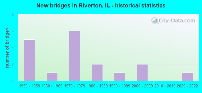
- New bridges - historical statistics
- 51950-1959
- 11960-1969
- 61970-1979
- 21980-1989
- 11990-1999
- 22000-2009
- 12020-2022

- Reconstructed bridges - Historical Statistics
- 11990-1999
- 32000-2009


- Bridge Condition - Deck
- 8.3%Very good
- 66.7%Good
- 16.7%Satisfactory
- 8.3%Fair

- Bridge Condition - Superstructure
- 15.4%Very good
- 38.5%Good
- 23.1%Satisfactory
- 15.4%Fair
- 7.7%Poor

- Bridge Condition - Substructure
- 7.7%Very good
- 76.9%Good
- 7.7%Satisfactory
- 7.7%Poor

- Bridge Condition - Channel
- 20.0%Very good
- 70.0%Good
- 10.0%Satisfactory
Find on map >> Show street view
Structure Number: 840052, Location: SW EDGE RIVERTON (Lat: 39.838328, Lng: -89.544439), Route carried "on" structure: Other road , Year Built: 1956, Year Reconstructed: 2006, Status: Open, Structure Length: 23.70m (77.76ft), Average Daily Traffic: 6,550 (year 2017), Truck Traffic: 15%, Average Future Daily Traffic: 3,762 (year 2032), Design Load: HS 20, Features Intersected: SANGAMON RIVER, Facility Carried by Structure: OLD US 36
Minimum Vertical Clearance: 30+ m (98+ ft), Kilometerpoint: 3.862, Lanes on structure: 2, Base Highway Network: Yes, Owner: State Highway Agency, Approaching Roadway Width: 12.8m (42.0ft), Skew: 2 degrees, Material/Design: Steel continuous, Design/Construction: Stringer/Multi-beam, Number Of Spans In Main Unit: 6, Length of Maximum Span: 48.8m (160.1ft), Curb-To-Curb Width: 11.0m (36.1ft), Out-to-Out Width: 11.0m (36.1ft)
Condition: Deck: Good, Superstructure: Satisfactory, Substructure: Satisfactory, Channel: Satisfactory, Operating Rating: 82.3 metric tons, Method Used To Determine Operating Rating: Load Factor (LF) rating reported by rating factor (RF) method using MS18 loading, Inventory Rating: 49.6 metric tons, Method Used To Determine Inventory Rating: Load Factor (LF) rating reported by rating factor (RF) method using MS18 loading, Structural Evaluation: Equal to present minimum criteria, Deck Geometry: Meets minimum limits, Waterway Adequacy: Superior to present desirable criteria, Approach Roadway Alignment: Equal to present desirable criteria, Designated Inspection Frequency: Every 24 months, Underwater Inspection Frequency: Every 24 months, Inspection Date: July 2021, Underwater Inspection Date: July 2021, Deck Structure Type: Concrete Cast-file-Place, Wearing Surface/Protective System: Deck Protection: Epoxy Coated Reinforcing
Find on map >> Show street view
Structure Number: 840053, Location: S EDGE RIVERTON (Lat: 39.840864, Lng: -89.539258), Route carried "on" structure: Other road , Year Built: 1958, Year Reconstructed: 2006, Status: Open, Structure Length: 3.95m (12.96ft), Average Daily Traffic: 2,150 (year 2021), Truck Traffic: 13%, Average Future Daily Traffic: 2,305 (year 2032), Design Load: HS 20, Features Intersected: 7TH ST. RAMP (NB), Facility Carried by Structure: OLD US 36
Minimum Vertical Clearance: 30+ m (98+ ft), Kilometerpoint: 3.331, Lanes on structure: 2, Lanes under structure: 1, Base Highway Network: Yes, Owner: State Highway Agency, Approaching Roadway Width: 9.8m (32.2ft), Skew: 4 degrees, Material/Design: Steel continuous, Design/Construction: Stringer/Multi-beam, Number Of Spans In Main Unit: 3, Length of Maximum Span: 14.0m (45.9ft), Curb-To-Curb Width: 10.3m (33.8ft), Out-to-Out Width: 11.2m (36.7ft)
Condition: Deck: Good, Superstructure: Very good, Substructure: Good, Operating Rating: 89.1 metric tons, Method Used To Determine Operating Rating: Load Factor (LF) rating reported by rating factor (RF) method using MS18 loading, Inventory Rating: 54.1 metric tons, Method Used To Determine Inventory Rating: Load Factor (LF) rating reported by rating factor (RF) method using MS18 loading, Structural Evaluation: Better than present minimum criteria, Deck Geometry: Meets minimum limits, Underclear: Meets minimum limits, Approach Roadway Alignment: Equal to present desirable criteria, Designated Inspection Frequency: Every 48 months, Inspection Date: Febuary 2021, Deck Structure Type: Concrete Cast-file-Place, Wearing Surface/Protective System: Deck Protection: Epoxy Coated Reinforcing
Find on map >> Show street view
Structure Number: 840151, Location: 2.9M E I-55 (Lat: 39.822317, Lng: -89.550078), Route carried "on" structure: County highway , Year Built: 1974, Status: Open, Structure Length: 8.06m (26.44ft), Average Daily Traffic: 1,650 (year 2017), Truck Traffic: 4%, Average Future Daily Traffic: 2,305 (year 2032), Design Load: HS 20, Features Intersected: I-72, Facility Carried by Structure: OAK CREST RD/ TR 1
Minimum Vertical Clearance: 30+ m (98+ ft), Kilometerpoint: 0.821, Lanes on structure: 2, Lanes under structure: 4, Owner: State Highway Agency, Approaching Roadway Width: 10.4m (34.1ft), Skew: 1 degrees, Material/Design: Steel continuous, Design/Construction: Stringer/Multi-beam, Number Of Spans In Main Unit: 2, Number Of Approach Spans: 2, Length of Maximum Span: 36.1m (118.4ft), Curb-To-Curb Width: 9.9m (32.5ft), Out-to-Out Width: 11.0m (36.1ft)
Condition: Deck: Good, Superstructure: Good, Substructure: Good, Operating Rating: 51.2 metric tons, Method Used To Determine Operating Rating: Load Factor (LF) rating reported by rating factor (RF) method using MS18 loading, Inventory Rating: 30.8 metric tons, Method Used To Determine Inventory Rating: Load Factor (LF) rating reported by rating factor (RF) method using MS18 loading, Structural Evaluation: Better than present minimum criteria, Deck Geometry: Somewhat better than minimum adequacy, Underclear: Meets minimum limits, Approach Roadway Alignment: Equal to present desirable criteria, Designated Inspection Frequency: Every 24 months, Inspection Date: January 2021, Deck Structure Type: Concrete Cast-file-Place, Wearing Surface/Protective System: Wearing Surface: Other
Find on map >> Show street view
Structure Number: 840152, Location: 3.5M E I-55 (Lat: 39.829703, Lng: -89.543444), Route carried "on" structure: Interstate 72, Year Built: 1974, Status: Open, Structure Length: 24.96m (81.89ft), Average Daily Traffic: 7,600 (year 2021), Truck Traffic: 21%, Average Future Daily Traffic: 7,075 (year 2032), Design Load: HS 20+Mod, Features Intersected: SANGAMON RIVER
Minimum Vertical Clearance: 30+ m (98+ ft), Kilometerpoint: 172.356, Lanes on structure: 2, Base Highway Network: Yes, Owner: State Highway Agency, Approaching Roadway Width: 12.8m (42.0ft), Material/Design: Steel continuous, Design/Construction: Box Beam or Girders - Single/Spread, Number Of Spans In Main Unit: 6, Length of Maximum Span: 49.4m (162.1ft), Curb-To-Curb Width: 11.7m (38.4ft), Out-to-Out Width: 12.8m (42.0ft)
Condition: Deck: Satisfactory, Superstructure: Fair, Substructure: Good, Channel: Good, Operating Rating: 51.2 metric tons, Method Used To Determine Operating Rating: Load Factor (LF) rating reported by rating factor (RF) method using MS18 loading, Inventory Rating: 30.8 metric tons, Method Used To Determine Inventory Rating: Load Factor (LF) rating reported by rating factor (RF) method using MS18 loading, Structural Evaluation: Somewhat better than minimum adequacy, Deck Geometry: Equal to present minimum criteria, Waterway Adequacy: Superior to present desirable criteria, Approach Roadway Alignment: Equal to present desirable criteria, Designated Inspection Frequency: Every 24 months, Other Special Inspection Frequency: Every 12 months, Inspection Date: December 2021, Other Special Inspection Date: December 2021, Deck Structure Type: Concrete Cast-file-Place, Wearing Surface/Protective System: Wearing Surface: Latex Concrete
Find on map >> Show street view
Structure Number: 840153, Location: 3.5M E I-55 (Lat: 39.829817, Lng: -89.543333), Route carried "on" structure: Interstate 72, Year Built: 1974, Status: Open, Structure Length: 24.96m (81.89ft), Average Daily Traffic: 7,600 (year 2021), Truck Traffic: 21%, Average Future Daily Traffic: 7,075 (year 2032), Design Load: HS 20+Mod, Features Intersected: SANGAMON RIVER
Minimum Vertical Clearance: 30+ m (98+ ft), Kilometerpoint: 172.372, Lanes on structure: 2, Base Highway Network: Yes, Owner: State Highway Agency, Approaching Roadway Width: 12.8m (42.0ft), Material/Design: Steel continuous, Design/Construction: Box Beam or Girders - Single/Spread, Number Of Spans In Main Unit: 6, Length of Maximum Span: 49.4m (162.1ft), Curb-To-Curb Width: 11.7m (38.4ft), Out-to-Out Width: 12.8m (42.0ft)
Condition: Deck: Satisfactory, Superstructure: Fair, Substructure: Good, Channel: Good, Operating Rating: 51.2 metric tons, Method Used To Determine Operating Rating: Load Factor (LF) rating reported by rating factor (RF) method using MS18 loading, Inventory Rating: 30.8 metric tons, Method Used To Determine Inventory Rating: Load Factor (LF) rating reported by rating factor (RF) method using MS18 loading, Structural Evaluation: Somewhat better than minimum adequacy, Deck Geometry: Equal to present minimum criteria, Waterway Adequacy: Superior to present desirable criteria, Approach Roadway Alignment: Equal to present desirable criteria, Designated Inspection Frequency: Every 24 months, Other Special Inspection Frequency: Every 12 months, Inspection Date: December 2021, Other Special Inspection Date: December 2021, Deck Structure Type: Concrete Cast-file-Place, Wearing Surface/Protective System: Wearing Surface: Latex Concrete
Find on map >> Show street view
Structure Number: 840154, Location: 1.4M E SANGAMON R. (Lat: 39.838164, Lng: -89.520639), Route carried "on" structure: Other road , Year Built: 1974, Year Reconstructed: 2014, Status: Open, Structure Length: 7.86m (25.79ft), Average Daily Traffic: 2,450 (year 2021), Truck Traffic: 12%, Average Future Daily Traffic: 2,787 (year 2032), Design Load: HS 20+Mod, Features Intersected: I-72 / US 36, Facility Carried by Structure: OVERPASS RD / TR 4
Minimum Vertical Clearance: 30+ m (98+ ft), Kilometerpoint: 2.639, Lanes on structure: 2, Lanes under structure: 4, Base Highway Network: Yes, Owner: State Highway Agency, Approaching Roadway Width: 14.6m (47.9ft), Skew: 30 degrees, Material/Design: Steel continuous, Design/Construction: Stringer/Multi-beam, Number Of Spans In Main Unit: 2, Number Of Approach Spans: 2, Length of Maximum Span: 30.2m (99.1ft), Curb-To-Curb Width: 14.5m (47.6ft), Out-to-Out Width: 20.7m (67.9ft)
Condition: Deck: Good, Superstructure: Satisfactory, Substructure: Good, Operating Rating: 69.3 metric tons, Method Used To Determine Operating Rating: Load Factor (LF) rating reported by rating factor (RF) method using MS18 loading, Inventory Rating: 41.5 metric tons, Method Used To Determine Inventory Rating: Load Factor (LF) rating reported by rating factor (RF) method using MS18 loading, Structural Evaluation: Equal to present minimum criteria, Deck Geometry: Superior to present desirable criteria, Underclear: Meets minimum limits, Approach Roadway Alignment: Equal to present desirable criteria, Designated Inspection Frequency: Every 24 months, Inspection Date: December 2021, Deck Structure Type: Concrete Cast-file-Place, Wearing Surface/Protective System: Deck Protection: Epoxy Coated Reinforcing
Find on map >> Show street view
Structure Number: 840518, Location: 1.7M E IL 54 (Lat: 39.831222, Lng: -89.554442), Route carried "on" structure: Other road , Year Built: 2006, Status: Open, Structure Length: 7.04m (23.10ft), Average Daily Traffic: 4,400 (year 2012), Truck Traffic: 13%, Average Future Daily Traffic: 4,288 (year 2032), Design Load: HS 20, Features Intersected: OLD 36 (WB), Facility Carried by Structure: CAMP BUTLER RD.
Minimum Vertical Clearance: 30+ m (98+ ft), Kilometerpoint: 2.945, Lanes on structure: 2, Lanes under structure: 2, Base Highway Network: Yes, Owner: State Highway Agency, Approaching Roadway Width: 8.8m (28.9ft), Skew: 5 degrees, Material/Design: Steel continuous, Design/Construction: Stringer/Multi-beam, Number Of Spans In Main Unit: 3, Length of Maximum Span: 29.3m (96.1ft), Curb-To-Curb Width: 7.9m (25.9ft), Out-to-Out Width: 8.9m (29.2ft)
Condition: Deck: Very good, Superstructure: Very good, Substructure: Very good, Operating Rating: 89.1 metric tons, Method Used To Determine Operating Rating: Load Factor (LF) rating reported by rating factor (RF) method using MS18 loading, Inventory Rating: 63.5 metric tons, Method Used To Determine Inventory Rating: Load Factor (LF) rating reported by rating factor (RF) method using MS18 loading, Structural Evaluation: Equal to present desirable criteria, Deck Geometry: High priority of replacement, Underclear: Superior to present desirable criteria, Approach Roadway Alignment: Better than present minimum criteria, Designated Inspection Frequency: Every 48 months, Inspection Date: Febuary 2019, Deck Structure Type: Concrete Cast-file-Place, Wearing Surface/Protective System: Deck Protection: Epoxy Coated Reinforcing
Find on map >> Show street view
Structure Number: 843021, Location: 3.5 MI NE ROCHESTER (Lat: 39.802694, Lng: -89.498611), Route carried "on" structure: County highway , Year Built: 1957, Year Reconstructed: 1996, Status: Open, Structure Length: 23.47m (77.00ft), Average Daily Traffic: 1,750 (year 2017), Truck Traffic: 21%, Average Future Daily Traffic: 1,876 (year 2032), Design Load: HS 20, Features Intersected: SANGAMON RIVER, Facility Carried by Structure: COUNTY HWY 12
Minimum Vertical Clearance: 30+ m (98+ ft), Kilometerpoint: 3.508, Lanes on structure: 2, Owner: County Highway Agency, Approaching Roadway Width: 7.3m (24.0ft), Material/Design: Steel, Design/Construction: Stringer/Multi-beam, Number Of Spans In Main Unit: 3, Number Of Approach Spans: 7, Length of Maximum Span: 45.7m (149.9ft), Curb-To-Curb Width: 9.1m (29.9ft), Out-to-Out Width: 9.1m (29.9ft)
Condition: Deck: Good, Superstructure: Good, Substructure: Good, Channel: Good, Operating Rating: 44.4 metric tons, Method Used To Determine Operating Rating: Load Factor (LF) rating reported by rating factor (RF) method using MS18 loading, Inventory Rating: 32.4 metric tons, Method Used To Determine Inventory Rating: Load Factor (LF) rating reported by rating factor (RF) method using MS18 loading, Structural Evaluation: Better than present minimum criteria, Deck Geometry: Somewhat better than minimum adequacy, Waterway Adequacy: Equal to present desirable criteria, Approach Roadway Alignment: Equal to present desirable criteria, Designated Inspection Frequency: Every 24 months, Inspection Date: August 2021, Deck Structure Type: Concrete Cast-file-Place
Find on map >> Show street view
Structure Number: 843106, Location: 2.0 E OF CLEAR LAKE (Lat: 39.823014, Lng: -89.544469), Route carried "on" structure: County highway , Year Built: 1950, Status: Posted for load, Structure Length: 8.75m (28.71ft), Average Daily Traffic: 425 (year 2017), Truck Traffic: 4%, Average Future Daily Traffic: 402 (year 2032), Design Load: H 15, Features Intersected: SANGAMON RIVER, Facility Carried by Structure: TR 171
Minimum Vertical Clearance: 5.54m (18.18ft), Kilometerpoint: 1.336, Lanes on structure: 2, Owner: Town or Township Highway Agency, Approaching Roadway Width: 5.5m (18.0ft), Material/Design: Steel, Design/Construction: Truss - Thru, Number Of Spans In Main Unit: 2, Length of Maximum Span: 43.0m (141.1ft), Curb-To-Curb Width: 6.2m (20.3ft), Out-to-Out Width: 6.7m (22.0ft)
Condition: Deck: Fair, Superstructure: Poor, Substructure: Poor, Channel: Good, Operating Rating: 9.4 metric tons, Method Used To Determine Operating Rating: Load Factor (LF) rating reported by rating factor (RF) method using MS18 loading, Inventory Rating: 5.5 metric tons, Method Used To Determine Inventory Rating: Load Factor (LF) rating reported by rating factor (RF) method using MS18 loading, Structural Evaluation: High priority of replacement, Deck Geometry: High priority of corrective action, Waterway Adequacy: Equal to present minimum criteria, Approach Roadway Alignment: High priority of corrective action, Bridge Posting: Required (Relationship of Operating Rating to Maximum Legal Load: > 39.9% below), Length Of Structure Improvement: 9.63m (31.59ft), Designated Inspection Frequency: Every 24 months, Critical Feature Inspection Frequency: Every 12 months, Underwater Inspection Frequency: Every 60 months, Inspection Date: March 2021, Critical Feature Inspection Date: March 2021, Underwater Inspection Date: August 2016, Bridge Improvement Cost: $556,000, Roadway Improvement Cost: $56,000, Total Project Cost: $834,000, Deck Structure Type: Concrete Cast-file-Place
Find on map >> Show street view
Structure Number: 843167, Location: 1.0E OF CLEAR LAKE (Lat: 39.810008, Lng: -89.550806), Route carried "on" structure: County highway , Year Built: 1963, Status: Open, Structure Length: 6.58m (21.59ft), Average Daily Traffic: 550 (year 2012), Truck Traffic: 7%, Average Future Daily Traffic: 536 (year 2032), Design Load: HS 20, Features Intersected: SUGAR CREEK, Facility Carried by Structure: TR 380
Minimum Vertical Clearance: 30+ m (98+ ft), Kilometerpoint: 1.432, Lanes on structure: 2, Owner: Town or Township Highway Agency, Approaching Roadway Width: 6.1m (20.0ft), Skew: 1 degrees, Material/Design: Steel continuous, Design/Construction: Stringer/Multi-beam, Number Of Spans In Main Unit: 3, Length of Maximum Span: 24.8m (81.4ft), Curb-To-Curb Width: 7.9m (25.9ft), Out-to-Out Width: 9.2m (30.2ft)
Condition: Deck: Good, Superstructure: Good, Substructure: Good, Channel: Good, Operating Rating: 83.3 metric tons, Method Used To Determine Operating Rating: Load Factor (LF) rating reported by rating factor (RF) method using MS18 loading, Inventory Rating: 49.9 metric tons, Method Used To Determine Inventory Rating: Load Factor (LF) rating reported by rating factor (RF) method using MS18 loading, Structural Evaluation: Better than present minimum criteria, Deck Geometry: Somewhat better than minimum adequacy, Waterway Adequacy: Equal to present desirable criteria, Approach Roadway Alignment: Equal to present minimum criteria, Designated Inspection Frequency: Every 24 months, Inspection Date: September 2021, Deck Structure Type: Concrete Cast-file-Place
Find on map >> Show street view
Structure Number: 843446, Location: 2.5 S OF RIVERTON (Lat: 39.802019, Lng: -89.542058), Route carried "on" structure: Other road , Year Built: 1981, Status: Open, Structure Length: 15.15m (49.70ft), Average Daily Traffic: 1,800 (year 2017), Truck Traffic: 15%, Average Future Daily Traffic: 3,966 (year 2032), Design Load: HS 20, Features Intersected: SOUTH FORK SANGAMON, Facility Carried by Structure: RT 630 BP 129
Minimum Vertical Clearance: 30+ m (98+ ft), Kilometerpoint: 12.215, Lanes on structure: 2, Owner: County Highway Agency, Approaching Roadway Width: 7.3m (24.0ft), Skew: 4 degrees, Material/Design: Steel continuous, Design/Construction: Stringer/Multi-beam, Number Of Spans In Main Unit: 4, Length of Maximum Span: 42.1m (138.1ft), Curb-To-Curb Width: 9.1m (29.9ft), Out-to-Out Width: 10.1m (33.1ft)
Condition: Deck: Good, Superstructure: Satisfactory, Substructure: Good, Channel: Very good, Operating Rating: 44.4 metric tons, Method Used To Determine Operating Rating: Assigned rating based on Load Factor Design (LFD) reported by rating factor (RF) using MS18 loading, Inventory Rating: 32.4 metric tons, Method Used To Determine Inventory Rating: Assigned rating based on Load Factor Design (LFD) reported by rating factor (RF) using MS18 loading, Structural Evaluation: Equal to present minimum criteria, Deck Geometry: Somewhat better than minimum adequacy, Waterway Adequacy: Equal to present desirable criteria, Approach Roadway Alignment: Equal to present desirable criteria, Designated Inspection Frequency: Every 24 months, Inspection Date: March 2021, Deck Structure Type: Concrete Cast-file-Place
Find on map >> Show street view
Structure Number: 84352, Location: 4.0 S OF DAWSON (Lat: 39.792475, Lng: -89.482514), Route carried "on" structure: County highway , Year Built: 1984, Status: Open, Structure Length: 4.51m (14.80ft), Average Daily Traffic: 125 (year 2012), Average Future Daily Traffic: 268 (year 2032), Design Load: HS 20, Features Intersected: CLEAR CREEK, Facility Carried by Structure: TR 209
Minimum Vertical Clearance: 30+ m (98+ ft), Kilometerpoint: 1.127, Lanes on structure: 2, Owner: Town or Township Highway Agency, Approaching Roadway Width: 4.3m (14.1ft), Material/Design: Prestressed concrete, Design/Construction: Box Beam or Girders - Multiple, Number Of Spans In Main Unit: 3, Length of Maximum Span: 19.8m (65.0ft), Curb-To-Curb Width: 8.2m (26.9ft), Out-to-Out Width: 8.2m (26.9ft)
Condition: Deck: Good, Superstructure: Good, Substructure: Good, Channel: Good, Operating Rating: 44.4 metric tons, Method Used To Determine Operating Rating: Assigned rating based on Load Factor Design (LFD) reported by rating factor (RF) using MS18 loading, Inventory Rating: 32.4 metric tons, Method Used To Determine Inventory Rating: Assigned rating based on Load Factor Design (LFD) reported by rating factor (RF) using MS18 loading, Structural Evaluation: Better than present minimum criteria, Deck Geometry: Somewhat better than minimum adequacy, Waterway Adequacy: Equal to present desirable criteria, Approach Roadway Alignment: Equal to present desirable criteria, Designated Inspection Frequency: Every 48 months, Inspection Date: March 2019, Deck Structure Type: Concrete Precast Panels, Wearing Surface/Protective System: Wearing Surface: Bituminous
Find on map >> Show street view
Structure Number: 84503, Location: 1.3 M SE of Riverton (Lat: 39.825844, Lng: -89.516278), Route carried "on" structure: County highway , Year Built: 2020, Status: Open, Structure Length: 0.68m (2.23ft), Average Daily Traffic: 550 (year 2017), Average Future Daily Traffic: 560 (year 2043), Design Load: HS 25 or greater, Features Intersected: TRIB to Clear Lake, Facility Carried by Structure: TR 171(Oak Crest R
Minimum Vertical Clearance: 30+ m (98+ ft), Kilometerpoint: 3.878, Lanes on structure: 2, Owner: Town or Township Highway Agency, Approaching Roadway Width: 6.7m (22.0ft), Material/Design: Concrete continuous, Design/Construction: Culvert, Length of Maximum Span: 0.0m, Curb-To-Curb Width: 9.1m (29.9ft)
Condition: Channel: Very good, Culverts: Very good, Operating Rating: 55.7 metric tons, Method Used To Determine Operating Rating: Load and Resistance Factor Rating (LRFR) rating reported by rating factor(RF) method using HL-93 loadings, Inventory Rating: 42.8 metric tons, Method Used To Determine Inventory Rating: Load and Resistance Factor Rating (LRFR) rating reported by rating factor(RF) method using HL-93 loadings, Structural Evaluation: Equal to present desirable criteria, Deck Geometry: Equal to present minimum criteria, Waterway Adequacy: Equal to present desirable criteria, Approach Roadway Alignment: Equal to present desirable criteria, Designated Inspection Frequency: Every 24 months, Inspection Date: April 2021
Find on map >> Show street view
Structure Number: 846501, Location: RIVERTON,ILLINOIS (Lat: 39.849594, Lng: -89.537319), Route carried "on" structure: City street , Year Built: 1997, Status: Open, Structure Length: 0.88m (2.89ft), Average Daily Traffic: 150 (year 2017), Average Future Daily Traffic: 31 (year 2032), Design Load: HS 20, Features Intersected: CLAY-CREEK, Facility Carried by Structure: KINZIE ST{MS 1100}
Minimum Vertical Clearance: 30+ m (98+ ft), Kilometerpoint: 0.193, Lanes on structure: 2, Owner: City or Municipal Highway Agency, Approaching Roadway Width: 6.1m (20.0ft), Material/Design: Concrete, Design/Construction: Frame, Number Of Spans In Main Unit: 1, Length of Maximum Span: 8.5m (27.9ft), Curb-To-Curb Width: 13.2m (43.3ft), Out-to-Out Width: 13.2m (43.3ft)
Condition: Superstructure: Good, Substructure: Good, Channel: Good, Operating Rating: 44.1 metric tons, Method Used To Determine Operating Rating: Assigned rating based on Load Factor Design (LFD) reported by rating factor (RF) using MS18 loading, Inventory Rating: 32.4 metric tons, Method Used To Determine Inventory Rating: Assigned rating based on Load Factor Design (LFD) reported by rating factor (RF) using MS18 loading, Structural Evaluation: Better than present minimum criteria, Deck Geometry: Superior to present desirable criteria, Waterway Adequacy: Equal to present desirable criteria, Approach Roadway Alignment: Equal to present desirable criteria, Designated Inspection Frequency: Every 48 months, Inspection Date: March 2021, Deck Structure Type: Other
Find on map >> Show street view
Structure Number: 840053, Location: S EDGE RIVERTON (Lat: 39.840794, Lng: -89.539544), Route carried "under" structure: Other road , Year Built: 1958, Structure Length: 0. m, Average Daily Traffic: 2,900 (year 2017), Truck Traffic: 8%, Features Intersected: 7TH ST. RAMP (NB), Facility Carried by Structure: OLD US 36
Minimum Vertical Clearance: 4.60m (15.09ft), Kilometerpoint: 0.418, Lanes on structure: 2, Lanes under structure: 1, Material/Design: Steel continuous, Design/Construction: Stringer/Multi-beam, Length of Maximum Span: 14.0m (45.9ft)
Find on map >> Show street view
Structure Number: 840151, Location: 2.9M E I-55 (Lat: 39.822319, Lng: -89.549664), Route carried "under" structure: Interstate 72, Year Built: 1974, Structure Length: 0. m, Average Daily Traffic: 15,200 (year 2021), Truck Traffic: 21%, Features Intersected: I-72, Facility Carried by Structure: OAK CREST RD/ TR 1
Minimum Vertical Clearance: 5.49m (18.01ft), Kilometerpoint: 171.358, Lanes on structure: 2, Lanes under structure: 4, Material/Design: Steel continuous, Design/Construction: Stringer/Multi-beam, Length of Maximum Span: 36.1m (118.4ft)
Find on map >> Show street view
Structure Number: 840154, Location: 1.4M E SANGAMON R. (Lat: 39.837661, Lng: -89.520631), Route carried "under" structure: Interstate 72, Year Built: 1974, Structure Length: 0. m, Average Daily Traffic: 15,200 (year 2021), Truck Traffic: 21%, Features Intersected: I-72 / US 36, Facility Carried by Structure: OVERPASS RD / TR 4
Minimum Vertical Clearance: 4.98m (16.34ft), Kilometerpoint: 174.641, Lanes on structure: 2, Lanes under structure: 4, Material/Design: Steel continuous, Design/Construction: Stringer/Multi-beam, Length of Maximum Span: 30.2m (99.1ft)
Find on map >> Show street view
Structure Number: 840518, Location: 1.7M E IL 54 (Lat: 39.831283, Lng: -89.554022), Route carried "under" structure: Other road , Year Built: 2006, Structure Length: 0. m, Average Daily Traffic: 6,550 (year 2017), Truck Traffic: 15%, Features Intersected: OLD 36 (WB), Facility Carried by Structure: CAMP BUTLER RD.
Minimum Vertical Clearance: 4.78m (15.68ft), Kilometerpoint: 4.989, Lanes on structure: 2, Lanes under structure: 2, Material/Design: Steel continuous, Design/Construction: Stringer/Multi-beam, Length of Maximum Span: 29.3m (96.1ft)