Bridge Statistics for Riverside, Ohio (OH)
Condition, Traffic, Stress, Structural Evaluation, Project Costs
- National Bridge Inventory (NBI) Statistics
- 22Number of bridges
- 177ft / 53.6mTotal length
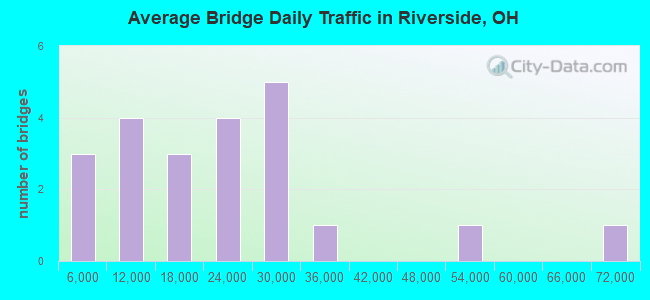
- 447,903Total average daily traffic
- 22,270Total average daily truck traffic
- National Bridge Inventory (NBI) Registered Bridges for Riverside
- No street view available for this location
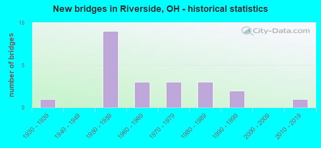
- New bridges - historical statistics
- 11930-1939
- 91950-1959
- 31960-1969
- 31970-1979
- 31980-1989
- 21990-1999
- 12010-2019
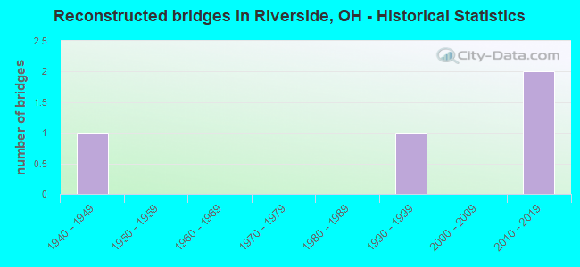
- Reconstructed bridges - Historical Statistics
- 11940-1949
- 01950-1959
- 01960-1969
- 01970-1979
- 01980-1989
- 11990-1999
- 02000-2009
- 22010-2019
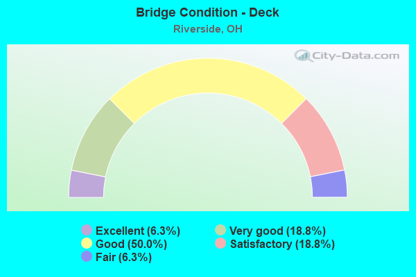
- Bridge Condition - Deck
- 6.3%Excellent
- 18.8%Very good
- 50.0%Good
- 18.8%Satisfactory
- 6.3%Fair
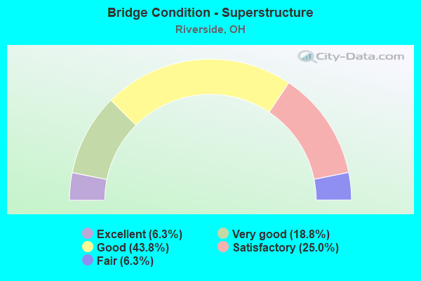
- Bridge Condition - Superstructure
- 6.3%Excellent
- 18.8%Very good
- 43.8%Good
- 25.0%Satisfactory
- 6.3%Fair
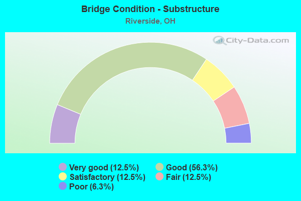
- Bridge Condition - Substructure
- 12.5%Very good
- 56.3%Good
- 12.5%Satisfactory
- 12.5%Fair
- 6.3%Poor
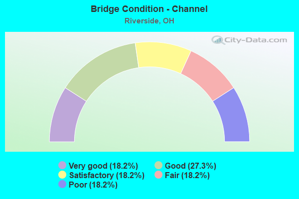
- Bridge Condition - Channel
- 18.2%Very good
- 27.3%Good
- 18.2%Satisfactory
- 18.2%Fair
- 18.2%Poor
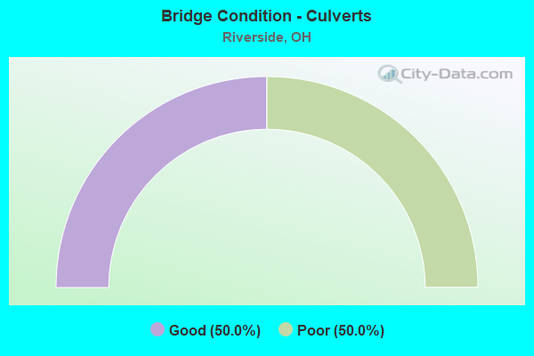
- Bridge Condition - Culverts
- 50.0%Good
- 50.0%Poor
Find on map >> Show street view
Structure Number: 5700906, Location: 1.25MI.SW. OF JCT. SR-444 (Lat: 39.792911, Lng: -84.127761), Route carried "on" structure: State highway 4, Year Built: 1959, Status: Open, Structure Length: 6.13m (20.11ft), Average Daily Traffic: 9,895 (year 2015), Truck Traffic: 9%, Average Future Daily Traffic: 13,734 (year 2035), Design Load: HS 20, Features Intersected: C51(HARSHMAN ROAD)
Minimum Vertical Clearance: 30+ m (98+ ft), Kilometerpoint: 32.992, Lanes on structure: 2, Lanes under structure: 6, Base Highway Network: Yes, Owner: State Highway Agency, Approaching Roadway Width: 10.7m (35.1ft), Material/Design: Concrete continuous, Design/Construction: Slab, Number Of Spans In Main Unit: 4, Length of Maximum Span: 15.9m (52.2ft), Curb-To-Curb Width: 18.4m (60.4ft), Out-to-Out Width: 19.4m (63.6ft)
Condition: Deck: Satisfactory, Superstructure: Satisfactory, Substructure: Good, Operating Rating: 42.1 metric tons, Method Used To Determine Operating Rating: Load Factor (LF) rating reported by rating factor (RF) method using MS18 loading, Inventory Rating: 32.4 metric tons, Method Used To Determine Inventory Rating: Load Factor (LF) rating reported by rating factor (RF) method using MS18 loading, Structural Evaluation: Equal to present minimum criteria, Deck Geometry: Superior to present desirable criteria, Underclear: Somewhat better than minimum adequacy, Approach Roadway Alignment: Superior to present desirable criteria, Designated Inspection Frequency: Every 12 months, Inspection Date: June 2021, Deck Structure Type: Concrete Cast-file-Place, Wearing Surface/Protective System: Wearing Surface: Integral Concrete
Find on map >> Show street view
Structure Number: 570093, Location: 1.25MI.SW. OF JCT. SR-444 (Lat: 39.793111, Lng: -84.127889), Route carried "on" structure: State highway 4, Year Built: 1959, Status: Open, Structure Length: 6.13m (20.11ft), Average Daily Traffic: 9,895 (year 2015), Truck Traffic: 9%, Average Future Daily Traffic: 13,734 (year 2035), Design Load: HS 20, Features Intersected: C51(HARSHMAN ROAD)
Minimum Vertical Clearance: 30+ m (98+ ft), Kilometerpoint: 32.992, Lanes on structure: 2, Lanes under structure: 2, Base Highway Network: Yes, Owner: State Highway Agency, Approaching Roadway Width: 10.7m (35.1ft), Material/Design: Concrete continuous, Design/Construction: Slab, Number Of Spans In Main Unit: 4, Length of Maximum Span: 15.9m (52.2ft), Curb-To-Curb Width: 14.8m (48.6ft), Out-to-Out Width: 15.7m (51.5ft)
Condition: Deck: Good, Superstructure: Good, Substructure: Good, Operating Rating: 42.1 metric tons, Method Used To Determine Operating Rating: Load Factor (LF) rating reported by rating factor (RF) method using MS18 loading, Inventory Rating: 32.4 metric tons, Method Used To Determine Inventory Rating: Load Factor (LF) rating reported by rating factor (RF) method using MS18 loading, Structural Evaluation: Better than present minimum criteria, Deck Geometry: Superior to present desirable criteria, Underclear: Somewhat better than minimum adequacy, Approach Roadway Alignment: Superior to present desirable criteria, Designated Inspection Frequency: Every 24 months, Inspection Date: June 2021, Deck Structure Type: Concrete Cast-file-Place, Wearing Surface/Protective System: Wearing Surface: Integral Concrete
Find on map >> Show street view
Structure Number: 5700965, Location: .83MI.SW. OF JCT. SR-444 (Lat: 39.795489, Lng: -84.120611), Route carried "on" structure: State highway 4, Year Built: 1959, Status: Open, Structure Length: 2.04m (6.69ft), Average Daily Traffic: 12,233 (year 2015), Truck Traffic: 9%, Average Future Daily Traffic: 16,979 (year 2035), Design Load: HS 20, Features Intersected: TRIBUTARY MAD RIVER
Minimum Vertical Clearance: 30+ m (98+ ft), Kilometerpoint: 33.667, Lanes on structure: 2, Base Highway Network: Yes, Owner: State Highway Agency, Approaching Roadway Width: 10.7m (35.1ft), Skew: 3 degrees, Material/Design: Concrete continuous, Design/Construction: Slab, Number Of Spans In Main Unit: 3, Length of Maximum Span: 6.7m (22.0ft), Curb-To-Curb Width: 17.1m (56.1ft), Out-to-Out Width: 17.1m (56.1ft)
Condition: Deck: Good, Superstructure: Good, Substructure: Good, Channel: Very good, Operating Rating: 32.4 metric tons, Method Used To Determine Operating Rating: Load Factor (LF) rating reported by rating factor (RF) method using MS18 loading, Inventory Rating: 25.9 metric tons, Method Used To Determine Inventory Rating: Load Factor (LF) rating reported by rating factor (RF) method using MS18 loading, Structural Evaluation: Equal to present minimum criteria, Deck Geometry: Superior to present desirable criteria, Waterway Adequacy: Superior to present desirable criteria, Approach Roadway Alignment: Superior to present desirable criteria, Designated Inspection Frequency: Every 24 months, Inspection Date: October 2021, Deck Structure Type: Concrete Cast-file-Place, Wearing Surface/Protective System: Wearing Surface: Integral Concrete
Find on map >> Show street view
Structure Number: 5701023, Location: .83MI.SW. OF JCT. SR-444 (Lat: 39.795739, Lng: -84.120589), Route carried "on" structure: State highway 4, Year Built: 1959, Status: Open, Structure Length: 2.04m (6.69ft), Average Daily Traffic: 12,233 (year 2015), Truck Traffic: 9%, Average Future Daily Traffic: 16,979 (year 2035), Design Load: HS 20, Features Intersected: TRIBUTARY MAD RIVER
Minimum Vertical Clearance: 30+ m (98+ ft), Kilometerpoint: 33.667, Lanes on structure: 2, Base Highway Network: Yes, Owner: State Highway Agency, Approaching Roadway Width: 10.7m (35.1ft), Skew: 3 degrees, Material/Design: Concrete continuous, Design/Construction: Slab, Number Of Spans In Main Unit: 3, Length of Maximum Span: 6.7m (22.0ft), Curb-To-Curb Width: 17.1m (56.1ft), Out-to-Out Width: 17.1m (56.1ft)
Condition: Deck: Very good, Superstructure: Very good, Substructure: Good, Channel: Very good, Operating Rating: 32.4 metric tons, Method Used To Determine Operating Rating: Load Factor (LF) rating reported by rating factor (RF) method using MS18 loading, Inventory Rating: 25.9 metric tons, Method Used To Determine Inventory Rating: Load Factor (LF) rating reported by rating factor (RF) method using MS18 loading, Structural Evaluation: Equal to present minimum criteria, Deck Geometry: Superior to present desirable criteria, Waterway Adequacy: Superior to present desirable criteria, Approach Roadway Alignment: Superior to present desirable criteria, Designated Inspection Frequency: Every 24 months, Inspection Date: October 2021, Deck Structure Type: Concrete Cast-file-Place, Wearing Surface/Protective System: Wearing Surface: Integral Concrete
Find on map >> Show street view
Structure Number: 5703069, Location: JCT. SR-835 (Lat: 39.745689, Lng: -84.120781), Route carried "on" structure: State highway 835, Year Built: 1965, Status: Open, Structure Length: 3.84m (12.60ft), Average Daily Traffic: 22,617 (year 2015), Truck Traffic: 7%, Average Future Daily Traffic: 31,392 (year 2035), Design Load: HS 20+Mod, Features Intersected: USR-35
Minimum Vertical Clearance: 30+ m (98+ ft), Kilometerpoint: 0.032, Lanes on structure: 5, Lanes under structure: 6, Base Highway Network: Yes, Owner: State Highway Agency, Approaching Roadway Width: 26.2m (86.0ft), Skew: 21 degrees, Material/Design: Steel continuous, Design/Construction: Stringer/Multi-beam, Number Of Spans In Main Unit: 2, Length of Maximum Span: 18.0m (59.1ft), Curb-To-Curb Width: 26.1m (85.6ft), Out-to-Out Width: 27.5m (90.2ft)
Condition: Deck: Good, Superstructure: Good, Substructure: Fair, Operating Rating: 42.1 metric tons, Method Used To Determine Operating Rating: Load Factor (LF) rating reported by rating factor (RF) method using MS18 loading, Inventory Rating: 32.4 metric tons, Method Used To Determine Inventory Rating: Load Factor (LF) rating reported by rating factor (RF) method using MS18 loading, Structural Evaluation: Somewhat better than minimum adequacy, Deck Geometry: Superior to present desirable criteria, Underclear: High priority of corrective action, Approach Roadway Alignment: Superior to present desirable criteria, Designated Inspection Frequency: Every 12 months, Inspection Date: October 2021, Deck Structure Type: Concrete Cast-file-Place, Wearing Surface/Protective System: Wearing Surface: Integral Concrete
Find on map >> Show street view
Structure Number: 5703107, Location: .5MI E. OF JCT SR835 (Lat: 39.743150, Lng: -84.111439), Route carried "on" structure: US 35, Year Built: 2012, Status: Open, Structure Length: 4.75m (15.58ft), Average Daily Traffic: 66,231 (year 2015), Truck Traffic: 4%, Average Future Daily Traffic: 91,929 (year 2035), Design Load: HL 93, Features Intersected: C115 (SPINNING ROAD)
Minimum Vertical Clearance: 30+ m (98+ ft), Kilometerpoint: 33.249, Lanes on structure: 4, Lanes under structure: 2, Base Highway Network: Yes, Owner: State Highway Agency, Approaching Roadway Width: 34.1m (111.9ft), Skew: 31 degrees, Material/Design: Steel continuous, Design/Construction: Stringer/Multi-beam, Number Of Spans In Main Unit: 3, Length of Maximum Span: 20.3m (66.6ft), Curb-To-Curb Width: 35.4m (116.1ft), Out-to-Out Width: 37.1m (121.7ft)
Condition: Deck: Very good, Superstructure: Excellent, Substructure: Very good, Operating Rating: 64.8 metric tons, Method Used To Determine Operating Rating: Load and Resistance Factor Rating (LRFR) rating reported by rating factor(RF) method using HL-93 loadings, Inventory Rating: 51.8 metric tons, Method Used To Determine Inventory Rating: Load and Resistance Factor Rating (LRFR) rating reported by rating factor(RF) method using HL-93 loadings, Structural Evaluation: Equal to present desirable criteria, Deck Geometry: Superior to present desirable criteria, Underclear: Equal to present minimum criteria, Approach Roadway Alignment: Superior to present desirable criteria, Designated Inspection Frequency: Every 24 months, Inspection Date: September 2021, Deck Structure Type: Concrete Cast-file-Place, Wearing Surface/Protective System: Wearing Surface: Monolithic Concrete, Membrane: Epoxy, Deck Protection: Epoxy Coated Reinforcing
Find on map >> Show street view
Structure Number: 577058, Location: 200 FT. NORTH AIRWAY RD. (Lat: 39.770000, Lng: -84.123131), Route carried "on" structure: City street M0074, Year Built: 1997, Status: Open, Structure Length: 1.16m (3.81ft), Average Daily Traffic: 31,443 (year 2018), Truck Traffic: 4%, Average Future Daily Traffic: 43,643 (year 2038), Design Load: HS 25 or greater, Features Intersected: Lilly Creek, Facility Carried by Structure: Woodman Dr M74
Minimum Vertical Clearance: 30+ m (98+ ft), Kilometerpoint: 3.718, Lanes on structure: 6, Base Highway Network: Yes, Owner: County Highway Agency, Approaching Roadway Width: 24.4m (80.1ft), Skew: 1 degrees, Material/Design: Concrete, Design/Construction: Slab, Number Of Spans In Main Unit: 1, Length of Maximum Span: 11.3m (37.1ft), Curb-To-Curb Width: 30.8m (101.0ft), Out-to-Out Width: 30.8m (101.0ft)
Condition: Deck: Good, Superstructure: Good, Substructure: Satisfactory, Channel: Good, Operating Rating: 81.0 metric tons, Method Used To Determine Operating Rating: Load Factor (LF) rating reported by rating factor (RF) method using MS18 loading, Inventory Rating: 48.6 metric tons, Method Used To Determine Inventory Rating: Load Factor (LF) rating reported by rating factor (RF) method using MS18 loading, Structural Evaluation: Equal to present minimum criteria, Deck Geometry: Superior to present desirable criteria, Waterway Adequacy: Superior to present desirable criteria, Approach Roadway Alignment: Equal to present desirable criteria, Designated Inspection Frequency: Every 12 months, Inspection Date: May 2021, Deck Structure Type: Concrete Cast-file-Place, Wearing Surface/Protective System: Wearing Surface: Monolithic Concrete, Deck Protection: Epoxy Coated Reinforcing
Find on map >> Show street view
Structure Number: 5770602, Location: 100 FT E OF WOODMAN DRIVE (Lat: 39.769731, Lng: -84.122331), Route carried "on" structure: City street M0194, Year Built: 1933, Year Reconstructed: 1953, Status: Open, Structure Length: 0.88m (2.89ft), Average Daily Traffic: 14,673 (year 2015), Truck Traffic: 5%, Average Future Daily Traffic: 20,366 (year 2035), Design Load: H 20, Features Intersected: Lilly Creek
Minimum Vertical Clearance: 30+ m (98+ ft), Kilometerpoint: 1.416, Lanes on structure: 5, Base Highway Network: Yes, Owner: County Highway Agency, Approaching Roadway Width: 16.5m (54.1ft), Skew: 3 degrees, Material/Design: Concrete, Design/Construction: Slab, Number Of Spans In Main Unit: 1, Length of Maximum Span: 7.6m (24.9ft), Curb or Sidewalk Widths: Left: 0.0m, Right: 0.3m (1.0ft), Curb-To-Curb Width: 18.3m (60.0ft), Out-to-Out Width: 20.9m (68.6ft)
Condition: Deck: Fair, Superstructure: Fair, Substructure: Poor, Channel: Poor, Operating Rating: 45.4 metric tons, Method Used To Determine Operating Rating: Load Factor (LF) rating reported by rating factor (RF) method using MS18 loading, Inventory Rating: 25.9 metric tons, Method Used To Determine Inventory Rating: Load Factor (LF) rating reported by rating factor (RF) method using MS18 loading, Structural Evaluation: Meets minimum limits, Deck Geometry: High priority of replacement, Waterway Adequacy: Better than present minimum criteria, Approach Roadway Alignment: Equal to present desirable criteria, Designated Inspection Frequency: Every 12 months, Inspection Date: May 2021, Deck Structure Type: Concrete Cast-file-Place, Wearing Surface/Protective System: Wearing Surface: Bituminous
Find on map >> Show street view
Structure Number: 5770629, Location: OVER GREAT MIAMI RIVER (Lat: 39.820119, Lng: -84.157169), Route carried "on" structure: City street M0074, Year Built: 1956, Year Reconstructed: 1996, Status: Open, Structure Length: 12.04m (39.50ft), Average Daily Traffic: 21,043 (year 2018), Truck Traffic: 5%, Average Future Daily Traffic: 29,208 (year 2038), Design Load: HS 20+Mod, Features Intersected: GREAT MIAMI RIVER
Minimum Vertical Clearance: 30+ m (98+ ft), Kilometerpoint: 11.684, Lanes on structure: 4, Base Highway Network: Yes, Owner: County Highway Agency, Approaching Roadway Width: 20.4m (66.9ft), Skew: 21 degrees, Material/Design: Steel continuous, Design/Construction: Stringer/Multi-beam, Number Of Spans In Main Unit: 5, Length of Maximum Span: 25.9m (85.0ft), Curb-To-Curb Width: 24.4m (80.1ft), Out-to-Out Width: 25.3m (83.0ft)
Condition: Deck: Good, Superstructure: Good, Substructure: Fair, Channel: Fair, Operating Rating: 64.8 metric tons, Method Used To Determine Operating Rating: Load Factor (LF) rating reported by rating factor (RF) method using MS18 loading, Inventory Rating: 38.9 metric tons, Method Used To Determine Inventory Rating: Load Factor (LF) rating reported by rating factor (RF) method using MS18 loading, Structural Evaluation: Somewhat better than minimum adequacy, Deck Geometry: Superior to present desirable criteria, Waterway Adequacy: Superior to present desirable criteria, Approach Roadway Alignment: Equal to present desirable criteria, Designated Inspection Frequency: Every 12 months, Underwater Inspection Frequency: Every 60 months, Inspection Date: June 2021, Underwater Inspection Date: August 2017, Deck Structure Type: Concrete Cast-file-Place, Wearing Surface/Protective System: Wearing Surface: Monolithic Concrete, Deck Protection: Epoxy Coated Reinforcing
Find on map >> Show street view
Structure Number: 5770661, Location: .8 MI S OF SR4 (Lat: 39.783039, Lng: -84.117919), Route carried "on" structure: County highway CR74, Year Built: 1978, Status: Open, Structure Length: 2.89m (9.48ft), Average Daily Traffic: 25,278 (year 2018), Truck Traffic: 5%, Average Future Daily Traffic: 35,086 (year 2038), Design Load: HS 20+Mod, Features Intersected: SPRINGFIELD ST, Facility Carried by Structure: HARSHMAN ROAD
Minimum Vertical Clearance: 30+ m (98+ ft), Kilometerpoint: 5.311, Lanes on structure: 4, Lanes under structure: 6, Base Highway Network: Yes, Owner: City or Municipal Highway Agency, Approaching Roadway Width: 21.3m (69.9ft), Skew: 10 degrees, Material/Design: Steel, Design/Construction: Stringer/Multi-beam, Number Of Spans In Main Unit: 1, Length of Maximum Span: 27.5m (90.2ft), Curb-To-Curb Width: 21.3m (69.9ft), Out-to-Out Width: 22.9m (75.1ft)
Condition: Deck: Good, Superstructure: Satisfactory, Substructure: Good, Operating Rating: 48.6 metric tons, Method Used To Determine Operating Rating: Load Factor (LF) rating reported by rating factor (RF) method using MS18 loading, Inventory Rating: 29.2 metric tons, Method Used To Determine Inventory Rating: Load Factor (LF) rating reported by rating factor (RF) method using MS18 loading, Structural Evaluation: Equal to present minimum criteria, Deck Geometry: Superior to present desirable criteria, Underclear: High priority of corrective action, Approach Roadway Alignment: Equal to present desirable criteria, Designated Inspection Frequency: Every 12 months, Inspection Date: June 2021, Deck Structure Type: Concrete Cast-file-Place, Wearing Surface/Protective System: Wearing Surface: Bituminous
Find on map >> Show street view
Structure Number: 5770696, Location: 0.2 MI S SPRINGFIELD ST (Lat: 39.775350, Lng: -84.132731), Route carried "on" structure: City street M3041, Year Built: 1956, Year Reconstructed: 2015, Status: Open, Structure Length: 0.88m (2.89ft), Average Daily Traffic: 895 (year 2018), Truck Traffic: 3%, Average Future Daily Traffic: 1,243 (year 2038), Design Load: HS 20, Features Intersected: LILLY CREEK, Facility Carried by Structure: FAIRPARK ROAD
Minimum Vertical Clearance: 30+ m (98+ ft), Kilometerpoint: 0.311, Lanes on structure: 2, Owner: City or Municipal Highway Agency, Approaching Roadway Width: 6.4m (21.0ft), Material/Design: Steel, Design/Construction: Stringer/Multi-beam, Number Of Spans In Main Unit: 1, Length of Maximum Span: 8.2m (26.9ft), Curb-To-Curb Width: 9.8m (32.2ft), Out-to-Out Width: 9.8m (32.2ft)
Condition: Deck: Excellent, Superstructure: Very good, Substructure: Good, Channel: Satisfactory, Operating Rating: 74.5 metric tons, Method Used To Determine Operating Rating: Load Factor (LF) rating reported by rating factor (RF) method using MS18 loading, Inventory Rating: 45.4 metric tons, Method Used To Determine Inventory Rating: Load Factor (LF) rating reported by rating factor (RF) method using MS18 loading, Structural Evaluation: Better than present minimum criteria, Deck Geometry: Equal to present minimum criteria, Waterway Adequacy: Equal to present minimum criteria, Approach Roadway Alignment: Equal to present minimum criteria, Designated Inspection Frequency: Every 24 months, Inspection Date: June 2021, Deck Structure Type: Concrete Cast-file-Place, Wearing Surface/Protective System: Wearing Surface: Monolithic Concrete, Membrane: Epoxy
Find on map >> Show street view
Structure Number: 5770742, Location: 1.4 MI SOUTH OF SR35 (Lat: 39.764050, Lng: -84.116219), Route carried "on" structure: City street M2640, Year Built: 1950, Status: Open, Structure Length: 0.73m (2.40ft), Average Daily Traffic: 478 (year 2018), Truck Traffic: 1%, Average Future Daily Traffic: 664 (year 2038), Features Intersected: LILLY CREEK, Facility Carried by Structure: OLENTANGY DR
Minimum Vertical Clearance: 30+ m (98+ ft), Kilometerpoint: 0.048, Lanes on structure: 2, Owner: City or Municipal Highway Agency, Approaching Roadway Width: 7.9m (25.9ft), Material/Design: Concrete, Design/Construction: Culvert, Number Of Spans In Main Unit: 2, Length of Maximum Span: 3.0m (9.8ft), Curb or Sidewalk Widths: Left: 1.2m (3.9ft), Right: 1.2m (3.9ft)
Condition: Channel: Fair, Culverts: Poor, Operating Rating: 55.1 metric tons, Method Used To Determine Operating Rating: Load Factor (LF) rating reported by rating factor (RF) method using MS18 loading, Inventory Rating: 32.4 metric tons, Method Used To Determine Inventory Rating: Load Factor (LF) rating reported by rating factor (RF) method using MS18 loading, Structural Evaluation: Meets minimum limits, Waterway Adequacy: Equal to present minimum criteria, Approach Roadway Alignment: Equal to present minimum criteria, Designated Inspection Frequency: Every 12 months, Inspection Date: June 2021
Find on map >> Show street view
Structure Number: 577075, Location: 50 FT N OF SR35 (Lat: 39.746511, Lng: -84.120631), Route carried "on" structure: County highway CR74, Year Built: 1962, Status: Open, Structure Length: 1.34m (4.40ft), Average Daily Traffic: 25,278 (year 2018), Truck Traffic: 5%, Average Future Daily Traffic: 35,086 (year 2038), Design Load: HS 20, Features Intersected: BIKEWAY, Facility Carried by Structure: WOODMAN DRIVE
Minimum Vertical Clearance: 30+ m (98+ ft), Kilometerpoint: 1.046, Lanes on structure: 5, Base Highway Network: Yes, Owner: City or Municipal Highway Agency, Approaching Roadway Width: 27.4m (89.9ft), Skew: 11 degrees, Material/Design: Prestressed concrete, Design/Construction: Box Beam or Girders - Multiple, Number Of Spans In Main Unit: 1, Length of Maximum Span: 12.8m (42.0ft), Curb or Sidewalk Widths: Left: 0.6m (2.0ft), Right: 0.6m (2.0ft), Curb-To-Curb Width: 25.6m (84.0ft), Out-to-Out Width: 27.4m (89.9ft)
Condition: Deck: Satisfactory, Superstructure: Satisfactory, Substructure: Satisfactory, Operating Rating: 48.6 metric tons, Method Used To Determine Operating Rating: Load Factor (LF) rating reported by rating factor (RF) method using MS18 loading, Inventory Rating: 22.7 metric tons, Method Used To Determine Inventory Rating: Load Factor (LF) rating reported by rating factor (RF) method using MS18 loading, Structural Evaluation: Somewhat better than minimum adequacy, Deck Geometry: Superior to present desirable criteria, Approach Roadway Alignment: Equal to present minimum criteria, Designated Inspection Frequency: Every 12 months, Inspection Date: June 2021, Deck Structure Type: Concrete Cast-file-Place, Wearing Surface/Protective System: Wearing Surface: Monolithic Concrete
Find on map >> Show street view
Structure Number: 5770769, Location: .8 MI NE OF HARSHMAN ROAD (Lat: 39.803611, Lng: -84.116900), Route carried "on" structure: City street M0525, Year Built: 1986, Year Reconstructed: 2017, Status: Open, Structure Length: 1.13m (3.71ft), Average Daily Traffic: 10,769 (year 2018), Truck Traffic: 4%, Average Future Daily Traffic: 14,947 (year 2038), Design Load: HS 20+Mod, Features Intersected: Trib. to Eastwood lake
Minimum Vertical Clearance: 30+ m (98+ ft), Kilometerpoint: 4.184, Lanes on structure: 2, Owner: County Highway Agency, Approaching Roadway Width: 14.0m (45.9ft), Skew: 1 degrees, Material/Design: Prestressed concrete, Design/Construction: Box Beam or Girders - Multiple, Number Of Spans In Main Unit: 1, Length of Maximum Span: 10.4m (34.1ft), Curb-To-Curb Width: 14.6m (47.9ft), Out-to-Out Width: 14.6m (47.9ft)
Condition: Deck: Very good, Superstructure: Very good, Substructure: Very good, Channel: Good, Operating Rating: 64.8 metric tons, Method Used To Determine Operating Rating: Load Factor (LF) rating reported by rating factor (RF) method using MS18 loading, Inventory Rating: 38.9 metric tons, Method Used To Determine Inventory Rating: Load Factor (LF) rating reported by rating factor (RF) method using MS18 loading, Structural Evaluation: Equal to present desirable criteria, Deck Geometry: Superior to present desirable criteria, Waterway Adequacy: Equal to present desirable criteria, Approach Roadway Alignment: Equal to present desirable criteria, Designated Inspection Frequency: Every 24 months, Inspection Date: May 2021, Deck Structure Type: Concrete Cast-file-Place, Wearing Surface/Protective System: Wearing Surface: Bituminous, Membrane: Built-up, Deck Protection: Other
Find on map >> Show street view
Structure Number: 5770777, Location: .6 MI S OF SR4 (Lat: 39.785250, Lng: -84.120169), Route carried "on" structure: County highway C0074, Year Built: 1998, Status: Open, Structure Length: 4.77m (15.65ft), Average Daily Traffic: 25,278 (year 2018), Truck Traffic: 5%, Average Future Daily Traffic: 35,086 (year 2038), Design Load: HS 20+Mod, Features Intersected: CONRAIL RR, Facility Carried by Structure: HARSHMAN ROAD
Minimum Vertical Clearance: 30+ m (98+ ft), Kilometerpoint: 11.835, Lanes on structure: 5, Base Highway Network: Yes, Owner: City or Municipal Highway Agency, Approaching Roadway Width: 25.2m (82.7ft), Skew: 11 degrees, Material/Design: Steel continuous, Design/Construction: Stringer/Multi-beam, Number Of Spans In Main Unit: 3, Length of Maximum Span: 18.1m (59.4ft), Curb-To-Curb Width: 25.2m (82.7ft), Out-to-Out Width: 28.4m (93.2ft)
Condition: Deck: Good, Superstructure: Good, Substructure: Good, Operating Rating: 68.0 metric tons, Method Used To Determine Operating Rating: Load Factor (LF) rating reported by rating factor (RF) method using MS18 loading, Inventory Rating: 42.1 metric tons, Method Used To Determine Inventory Rating: Load Factor (LF) rating reported by rating factor (RF) method using MS18 loading, Structural Evaluation: Better than present minimum criteria, Deck Geometry: Superior to present desirable criteria, Underclear: Better than present minimum criteria, Approach Roadway Alignment: Equal to present desirable criteria, Designated Inspection Frequency: Every 24 months, Inspection Date: June 2021, Deck Structure Type: Concrete Cast-file-Place, Wearing Surface/Protective System: Wearing Surface: Bituminous
Find on map >> Show street view
Structure Number: 5770785, Location: 0.2 MI EAST OF OH-201 (Lat: 39.821550, Lng: -84.121419), Route carried "on" structure: City street M1643, Year Built: 1976, Status: Posted for load, Structure Length: 0.98m (3.22ft), Average Daily Traffic: 135 (year 2018), Truck Traffic: 3%, Average Future Daily Traffic: 188 (year 2038), Design Load: HS 20+Mod, Features Intersected: STREAM, Facility Carried by Structure: RENFIELD DRIVE
Minimum Vertical Clearance: 30+ m (98+ ft), Kilometerpoint: 0.322, Lanes on structure: 2, Owner: City or Municipal Highway Agency, Approaching Roadway Width: 5.5m (18.0ft), Skew: 2 degrees, Material/Design: Steel, Design/Construction: Stringer/Multi-beam, Number Of Spans In Main Unit: 1, Length of Maximum Span: 9.1m (29.9ft), Curb-To-Curb Width: 7.0m (23.0ft), Out-to-Out Width: 7.3m (24.0ft)
Condition: Deck: Satisfactory, Superstructure: Satisfactory, Substructure: Good, Channel: Satisfactory, Operating Rating: 25.9 metric tons, Method Used To Determine Operating Rating: Load Factor (LF) rating reported by rating factor (RF) method using MS18 loading, Inventory Rating: 16.2 metric tons, Method Used To Determine Inventory Rating: Load Factor (LF) rating reported by rating factor (RF) method using MS18 loading, Structural Evaluation: Somewhat better than minimum adequacy, Deck Geometry: Meets minimum limits, Waterway Adequacy: Better than present minimum criteria, Approach Roadway Alignment: Better than present minimum criteria, Bridge Posting: Required (Relationship of Operating Rating to Maximum Legal Load: > 39.9% below), Designated Inspection Frequency: Every 12 months, Inspection Date: June 2021, Deck Structure Type: Corrugated Steel, Wearing Surface/Protective System: Wearing Surface: Bituminous, Membrane: Built-up
Find on map >> Show street view
Structure Number: 5770793, Location: 100 FT N OF VALLEY PIKE (Lat: 39.804831, Lng: -84.118011), Route carried "on" structure: City street M0102, Year Built: 1983, Status: Open, Structure Length: 1.10m (3.61ft), Average Daily Traffic: 8,021 (year 2013), Truck Traffic: 3%, Average Future Daily Traffic: 11,133 (year 2033), Design Load: HS 20+Mod, Features Intersected: Trib. Eastwood Lake, Facility Carried by Structure: Union Schoolhse
Minimum Vertical Clearance: 30+ m (98+ ft), Kilometerpoint: 0.129, Lanes on structure: 3, Owner: County Highway Agency, Approaching Roadway Width: 12.8m (42.0ft), Skew: 2 degrees, Material/Design: Prestressed concrete, Design/Construction: Box Beam or Girders - Multiple, Number Of Spans In Main Unit: 1, Length of Maximum Span: 10.4m (34.1ft), Curb or Sidewalk Widths: Left: 1.8m (5.9ft), Right: 0.3m (1.0ft), Curb-To-Curb Width: 12.8m (42.0ft), Out-to-Out Width: 14.6m (47.9ft)
Condition: Deck: Good, Superstructure: Good, Substructure: Good, Channel: Good, Operating Rating: 64.8 metric tons, Method Used To Determine Operating Rating: Load Factor (LF) rating reported by rating factor (RF) method using MS18 loading, Inventory Rating: 38.9 metric tons, Method Used To Determine Inventory Rating: Load Factor (LF) rating reported by rating factor (RF) method using MS18 loading, Structural Evaluation: Better than present minimum criteria, Deck Geometry: Meets minimum limits, Waterway Adequacy: Equal to present desirable criteria, Approach Roadway Alignment: Equal to present desirable criteria, Designated Inspection Frequency: Every 24 months, Inspection Date: May 2021, Deck Structure Type: Concrete Cast-file-Place, Wearing Surface/Protective System: Wearing Surface: Bituminous, Membrane: Built-up
Find on map >> Show street view
Structure Number: 5770823, Location: AT MONT CO. GREEN CO. LN. (Lat: 39.771000, Lng: -84.100300), Route carried "on" structure: City street M0194, Year Built: 1989, Status: Open, Structure Length: 0.73m (2.40ft), Average Daily Traffic: 22,658 (year 2012), Truck Traffic: 1%, Average Future Daily Traffic: 31,449 (year 2032), Design Load: HS 20+Mod, Features Intersected: Airway Road Ditch
Minimum Vertical Clearance: 30+ m (98+ ft), Kilometerpoint: 3.122, Lanes on structure: 5, Base Highway Network: Yes, Owner: County Highway Agency, Approaching Roadway Width: 24.4m (80.1ft), Material/Design: Concrete, Design/Construction: Culvert, Number Of Spans In Main Unit: 1, Length of Maximum Span: 6.7m (22.0ft)
Condition: Channel: Poor, Culverts: Good, Operating Rating: 58.3 metric tons, Method Used To Determine Operating Rating: Load Factor (LF) rating reported by rating factor (RF) method using MS18 loading, Inventory Rating: 35.6 metric tons, Method Used To Determine Inventory Rating: Load Factor (LF) rating reported by rating factor (RF) method using MS18 loading, Structural Evaluation: Better than present minimum criteria, Waterway Adequacy: Equal to present minimum criteria, Approach Roadway Alignment: Equal to present desirable criteria, Designated Inspection Frequency: Every 24 months, Inspection Date: May 2021
Find on map >> Show street view
Structure Number: 5700906, Location: 1.25MI.SW. OF JCT. SR-444 (Lat: 39.792911, Lng: -84.127761), Route carried "under" structure: County highway C0051, Year Built: 1959, Structure Length: 0. m, Average Daily Traffic: 29,053 (year 2015), Truck Traffic: 5%, Features Intersected: S4*S, Facility Carried by Structure: SR-4
Minimum Vertical Clearance: 4.62m (15.16ft), Kilometerpoint: 6.936, Lanes on structure: 2, Lanes under structure: 6, Material/Design: Concrete continuous, Design/Construction: Slab, Length of Maximum Span: 15.9m (52.2ft)
Find on map >> Show street view
Structure Number: 570093, Location: 1.25MI.SW. OF JCT. SR-444 (Lat: 39.793111, Lng: -84.127889), Route carried "under" structure: County highway C0051, Year Built: 1959, Structure Length: 0. m, Average Daily Traffic: 29,053 (year 2015), Truck Traffic: 5%, Features Intersected: S4*N, Facility Carried by Structure: SR-4
Minimum Vertical Clearance: 4.60m (15.09ft), Kilometerpoint: 69.202, Lanes on structure: 2, Lanes under structure: 2, Material/Design: Concrete continuous, Design/Construction: Slab, Length of Maximum Span: 15.9m (52.2ft)
Find on map >> Show street view
Structure Number: 5703069, Location: JCT. SR-835 (Lat: 39.745689, Lng: -84.120781), Route carried "under" structure: US 35, Year Built: 1965, Structure Length: 0. m, Average Daily Traffic: 51,917 (year 2015), Truck Traffic: 4%, Features Intersected: SR-835 ( WOODMAN DRIVE )
Minimum Vertical Clearance: 4.70m (15.42ft), Kilometerpoint: 32.380, Lanes on structure: 5, Lanes under structure: 6, Material/Design: Steel continuous, Design/Construction: Stringer/Multi-beam, Length of Maximum Span: 18.0m (59.1ft)
Find on map >> Show street view
Structure Number: 5770661, Location: .8 MI S OF SR4 (Lat: 39.783039, Lng: -84.117919), Route carried "under" structure: County highway CR536, Year Built: 1978, Structure Length: 0. m, Average Daily Traffic: 18,827 (year 2018), Truck Traffic: 7%, Features Intersected: HARSHMAN ROAD, Facility Carried by Structure: SPRINGFIELD STREET
Minimum Vertical Clearance: 4.52m (14.83ft), Kilometerpoint: 9.608, Lanes on structure: 4, Lanes under structure: 6, Material/Design: Steel, Design/Construction: Stringer/Multi-beam, Length of Maximum Span: 27.5m (90.2ft)