Bridge Statistics for River Hills, Wisconsin (WI)
Condition, Traffic, Stress, Structural Evaluation, Project Costs
- National Bridge Inventory (NBI) Statistics
- 17Number of bridges
- 236ft / 72.5mTotal length
- $5,989,000Total costs
- 486,939Total average daily traffic
- 20,811Total average daily truck traffic
- National Bridge Inventory (NBI) Registered Bridges for River Hills
- No street view available for this location
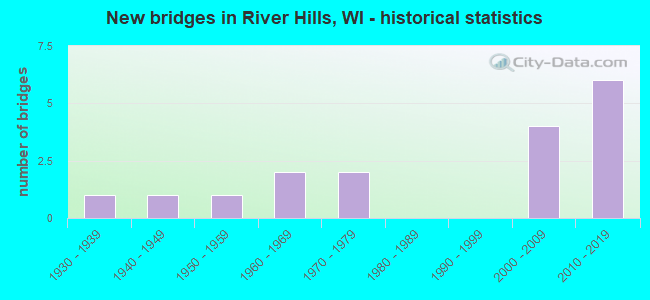
- New bridges - historical statistics
- 11930-1939
- 11940-1949
- 11950-1959
- 21960-1969
- 21970-1979
- 42000-2009
- 62010-2019

- Reconstructed bridges - Historical Statistics
- 21950-1959
- 01960-1969
- 01970-1979
- 01980-1989
- 21990-1999


- Bridge Condition - Deck
- 8.3%Very good
- 41.7%Good
- 25.0%Satisfactory
- 25.0%Fair

- Bridge Condition - Superstructure
- 8.3%Excellent
- 8.3%Very good
- 41.7%Good
- 33.3%Satisfactory
- 8.3%Fair

- Bridge Condition - Substructure
- 8.3%Excellent
- 25.0%Very good
- 33.3%Good
- 25.0%Satisfactory
- 8.3%Poor

- Bridge Condition - Channel
- 30.0%Very good
- 10.0%Good
- 60.0%Satisfactory

- Bridge Condition - Culverts
- 50.0%Satisfactory
- 50.0%Fair
Find on map >> Show street view
Structure Number: B400023, Location: 0.7 MI. SOUTH JCT STH 10 (Lat: 43.167153, Lng: -87.915711), Route carried "on" structure: Interstate 43, Year Built: 1956, Year Reconstructed: 1964, Status: Open, Structure Length: 0.99m (3.25ft), Average Daily Traffic: 85,900 (year 2019), Truck Traffic: 1%, Average Future Daily Traffic: 105,310 (year 2040), Design Load: HS 20, Features Intersected: INDIAN CREEK
Minimum Vertical Clearance: 30+ m (98+ ft), Kilometerpoint: 0.000, Lanes on structure: 6, Base Highway Network: Yes, Owner: State Highway Agency, Approaching Roadway Width: 25.0m (82.0ft), Skew: 31 degrees, Material/Design: Concrete continuous, Design/Construction: Culvert, Number Of Spans In Main Unit: 2, Length of Maximum Span: 4.6m (15.1ft)
Condition: Channel: Satisfactory, Culverts: Satisfactory, Operating Rating: 53.9 metric tons, Method Used To Determine Operating Rating: Field evaluation and documented engineering judgment, Inventory Rating: 32.4 metric tons, Method Used To Determine Inventory Rating: Field evaluation and documented engineering judgment, Structural Evaluation: Equal to present minimum criteria, Waterway Adequacy: Better than present minimum criteria, Approach Roadway Alignment: Equal to present desirable criteria, Designated Inspection Frequency: Every 24 months, Inspection Date: March 2021, Deck Structure Type: Concrete Cast-file-Place, Wearing Surface/Protective System: Wearing Surface: Monolithic Concrete
Find on map >> Show street view
Structure Number: B400374, Location: 0.6M E JCT STH 57 (Lat: 43.147739, Lng: -87.929047), Route carried "on" structure: County highway , Year Built: 1967, Year Reconstructed: 2001, Status: Open, Structure Length: 9.47m (31.07ft), Average Daily Traffic: 15,150 (year 2019), Truck Traffic: 7%, Average Future Daily Traffic: 32,884 (year 2039), Design Load: HS 20, Features Intersected: MILWAUKEE RIVER, Facility Carried by Structure: CTH PP W GOOD HOP
Minimum Vertical Clearance: 30+ m (98+ ft), Kilometerpoint: 0.000, Lanes on structure: 3, Base Highway Network: Yes, Owner: County Highway Agency, Approaching Roadway Width: 12.5m (41.0ft), Material/Design: Steel continuous, Design/Construction: Stringer/Multi-beam, Number Of Spans In Main Unit: 4, Length of Maximum Span: 25.9m (85.0ft), Curb or Sidewalk Widths: Left: 0.0m, Right: 2.0m (6.6ft), Curb-To-Curb Width: 12.5m (41.0ft), Out-to-Out Width: 15.1m (49.5ft)
Condition: Deck: Good, Superstructure: Good, Substructure: Satisfactory, Channel: Very good, Operating Rating: 37.6 metric tons, Method Used To Determine Operating Rating: Load Factor (LF), Inventory Rating: 22.7 metric tons, Method Used To Determine Inventory Rating: Load Factor (LF), Structural Evaluation: Somewhat better than minimum adequacy, Deck Geometry: Meets minimum limits, Waterway Adequacy: Equal to present desirable criteria, Approach Roadway Alignment: Equal to present desirable criteria, Designated Inspection Frequency: Every 24 months, Inspection Date: June 2020, Deck Structure Type: Concrete Cast-file-Place, Wearing Surface/Protective System: Wearing Surface: Monolithic Concrete, Deck Protection: Epoxy Coated Reinforcing
Find on map >> Show street view
Structure Number: B400375, Location: 0.6M W JCT IH 43 (Lat: 43.148083, Lng: -87.927878), Route carried "on" structure: County highway , Year Built: 1967, Year Reconstructed: 2001, Status: Open, Structure Length: 9.46m (31.04ft), Average Daily Traffic: 15,150 (year 2019), Truck Traffic: 7%, Average Future Daily Traffic: 32,884 (year 2039), Design Load: HS 20, Features Intersected: MILWAUKEE RIVER, Facility Carried by Structure: CTH PP W GOOD HOP
Minimum Vertical Clearance: 30+ m (98+ ft), Kilometerpoint: 0.000, Lanes on structure: 3, Base Highway Network: Yes, Owner: County Highway Agency, Approaching Roadway Width: 12.5m (41.0ft), Material/Design: Steel continuous, Design/Construction: Stringer/Multi-beam, Number Of Spans In Main Unit: 4, Length of Maximum Span: 25.9m (85.0ft), Curb or Sidewalk Widths: Left: 2.0m (6.6ft), Right: 0.0m, Curb-To-Curb Width: 12.5m (41.0ft), Out-to-Out Width: 15.1m (49.5ft)
Condition: Deck: Good, Superstructure: Good, Substructure: Satisfactory, Channel: Very good, Operating Rating: 37.6 metric tons, Method Used To Determine Operating Rating: Load Factor (LF), Inventory Rating: 22.7 metric tons, Method Used To Determine Inventory Rating: Load Factor (LF), Structural Evaluation: Somewhat better than minimum adequacy, Deck Geometry: Meets minimum limits, Waterway Adequacy: Equal to present desirable criteria, Approach Roadway Alignment: Equal to present desirable criteria, Designated Inspection Frequency: Every 24 months, Inspection Date: June 2020, Deck Structure Type: Concrete Cast-file-Place, Wearing Surface/Protective System: Wearing Surface: Monolithic Concrete, Deck Protection: Epoxy Coated Reinforcing
Find on map >> Show street view
Structure Number: B400436, Location: 0.3M S JCT CTH PP (Lat: 43.143083, Lng: -87.926047), Route carried "on" structure: City street , Year Built: 2002, Status: Open, Structure Length: 7.40m (24.28ft), Average Daily Traffic: 2,500 (year 2019), Truck Traffic: 6%, Average Future Daily Traffic: 4,059 (year 2039), Design Load: HS 20, Features Intersected: MILWAUKEE RIVER, Facility Carried by Structure: LRD GREEN TREE RD
Minimum Vertical Clearance: 30+ m (98+ ft), Kilometerpoint: 0.000, Lanes on structure: 2, Owner: City or Municipal Highway Agency, Approaching Roadway Width: 8.8m (28.9ft), Material/Design: Prestressed concrete continuous, Design/Construction: Stringer/Multi-beam, Number Of Spans In Main Unit: 3, Length of Maximum Span: 30.5m (100.1ft), Curb or Sidewalk Widths: Left: 2.0m (6.6ft), Right: 0.0m, Curb-To-Curb Width: 10.3m (33.8ft), Out-to-Out Width: 12.6m (41.3ft)
Condition: Deck: Good, Superstructure: Very good, Substructure: Good, Channel: Satisfactory, Operating Rating: 62.1 metric tons, Method Used To Determine Operating Rating: Load Factor (LF), Inventory Rating: 35.6 metric tons, Method Used To Determine Inventory Rating: Load Factor (LF), Structural Evaluation: Better than present minimum criteria, Deck Geometry: Meets minimum limits, Waterway Adequacy: Superior to present desirable criteria, Approach Roadway Alignment: Equal to present desirable criteria, Designated Inspection Frequency: Every 24 months, Inspection Date: September 2020, Deck Structure Type: Concrete Cast-file-Place, Wearing Surface/Protective System: Wearing Surface: Monolithic Concrete, Deck Protection: Epoxy Coated Reinforcing
Find on map >> Show street view
Structure Number: B400504, Location: 0.2M E JCT STH 57 (Lat: 43.178100, Lng: -87.956014), Route carried "on" structure: State highway 100, Year Built: 1979, Status: Open, Structure Length: 7.80m (25.59ft), Average Daily Traffic: 13,400 (year 2019), Truck Traffic: 3%, Average Future Daily Traffic: 31,810 (year 2039), Design Load: HS 20, Features Intersected: MILWAUKEE RIVER
Minimum Vertical Clearance: 30+ m (98+ ft), Kilometerpoint: 0.000, Lanes on structure: 4, Base Highway Network: Yes, Owner: State Highway Agency, Approaching Roadway Width: 12.2m (40.0ft), Skew: 30 degrees, Material/Design: Prestressed concrete continuous, Design/Construction: Stringer/Multi-beam, Number Of Spans In Main Unit: 3, Length of Maximum Span: 25.9m (85.0ft), Curb or Sidewalk Widths: Left: 4.3m (14.1ft), Right: 2.0m (6.6ft), Curb-To-Curb Width: 12.2m (40.0ft), Out-to-Out Width: 19.5m (64.0ft)
Condition: Deck: Fair, Superstructure: Satisfactory, Substructure: Good, Channel: Satisfactory, Operating Rating: 47.4 metric tons, Method Used To Determine Operating Rating: Load Factor (LF), Inventory Rating: 29.2 metric tons, Method Used To Determine Inventory Rating: Load Factor (LF), Structural Evaluation: Equal to present minimum criteria, Deck Geometry: High priority of replacement, Waterway Adequacy: Equal to present desirable criteria, Approach Roadway Alignment: Equal to present desirable criteria, Length Of Structure Improvement: 8.23m (27.00ft), Designated Inspection Frequency: Every 24 months, Inspection Date: April 2020, Bridge Improvement Cost: $1,316,000, Roadway Improvement Cost: $131,000, Total Project Cost: $1,974,000 ( Estimate for 2021), Deck Structure Type: Concrete Cast-file-Place, Wearing Surface/Protective System: Wearing Surface: Low Slump Concrete
Find on map >> Show street view
Structure Number: B400505, Location: 2.1M S JCT IH 43 (Lat: 43.178289, Lng: -87.954944), Route carried "on" structure: State highway 100, Year Built: 1979, Status: Open, Structure Length: 7.80m (25.59ft), Average Daily Traffic: 13,150 (year 2019), Truck Traffic: 3%, Average Future Daily Traffic: 16,469 (year 2039), Design Load: HS 20, Features Intersected: MILWAUKEE RIVER
Minimum Vertical Clearance: 30+ m (98+ ft), Kilometerpoint: 0.000, Lanes on structure: 3, Base Highway Network: Yes, Owner: State Highway Agency, Approaching Roadway Width: 12.2m (40.0ft), Skew: 30 degrees, Material/Design: Prestressed concrete continuous, Design/Construction: Stringer/Multi-beam, Number Of Spans In Main Unit: 3, Length of Maximum Span: 25.9m (85.0ft), Curb or Sidewalk Widths: Left: 4.3m (14.1ft), Right: 2.0m (6.6ft), Curb-To-Curb Width: 12.2m (40.0ft), Out-to-Out Width: 19.5m (64.0ft)
Condition: Deck: Fair, Superstructure: Satisfactory, Substructure: Good, Channel: Satisfactory, Operating Rating: 45.7 metric tons, Method Used To Determine Operating Rating: Load Factor (LF), Inventory Rating: 22.7 metric tons, Method Used To Determine Inventory Rating: Load Factor (LF), Structural Evaluation: Somewhat better than minimum adequacy, Deck Geometry: Meets minimum limits, Waterway Adequacy: Equal to present desirable criteria, Approach Roadway Alignment: Equal to present desirable criteria, Designated Inspection Frequency: Every 24 months, Inspection Date: April 2020, Deck Structure Type: Concrete Cast-file-Place, Wearing Surface/Protective System: Wearing Surface: Low Slump Concrete
Find on map >> Show street view
Structure Number: B400673, Location: 0.3M W.RIVER RD (Lat: 43.162511, Lng: -87.931386), Route carried "on" structure: City street , Year Built: 2002, Status: Open, Structure Length: 0.67m (2.20ft), Average Daily Traffic: 428 (year 2019), Average Future Daily Traffic: 470 (year 2039), Features Intersected: INDIAN CREEK, Facility Carried by Structure: LRD W BRADLEY RD
Minimum Vertical Clearance: 30+ m (98+ ft), Kilometerpoint: 0.000, Lanes on structure: 2, Owner: City or Municipal Highway Agency, Approaching Roadway Width: 4.3m (14.1ft), Skew: 3 degrees, Material/Design: Steel, Design/Construction: Culvert, Number Of Spans In Main Unit: 1, Length of Maximum Span: 6.6m (21.7ft)
Condition: Channel: Good, Culverts: Fair, Operating Rating: 53.9 metric tons, Method Used To Determine Operating Rating: Field evaluation and documented engineering judgment, Inventory Rating: 24.3 metric tons, Method Used To Determine Inventory Rating: Field evaluation and documented engineering judgment, Structural Evaluation: Somewhat better than minimum adequacy, Waterway Adequacy: Better than present minimum criteria, Approach Roadway Alignment: Equal to present desirable criteria, Designated Inspection Frequency: Every 24 months, Inspection Date: September 2020, Wearing Surface/Protective System: Wearing Surface: Bituminous
Find on map >> Show street view
Structure Number: B400731, Location: AT OAK LEAF TRAIL (Lat: 43.067389, Lng: -87.891306), Route carried "on" structure: City street , Year Built: 2009, Status: Open, Structure Length: 2.45m (8.04ft), Average Daily Traffic: 1,200 (year 2018), Average Future Daily Traffic: 226 (year 2039), Design Load: HS 20, Features Intersected: OAK LEAF TRAIL, Facility Carried by Structure: LRD EAST PARK PLAC
Minimum Vertical Clearance: 30+ m (98+ ft), Kilometerpoint: 0.000, Lanes on structure: 2, Owner: County Highway Agency, Approaching Roadway Width: 7.3m (24.0ft), Material/Design: Concrete continuous, Design/Construction: Slab, Number Of Spans In Main Unit: 2, Length of Maximum Span: 18.1m (59.4ft), Curb or Sidewalk Widths: Left: 3.0m (9.8ft), Right: 2.0m (6.6ft), Curb-To-Curb Width: 7.3m (24.0ft), Out-to-Out Width: 12.5m (41.0ft)
Condition: Deck: Satisfactory, Superstructure: Satisfactory, Substructure: Satisfactory, Operating Rating: 67.0 metric tons, Method Used To Determine Operating Rating: Load Factor (LF), Inventory Rating: 40.5 metric tons, Method Used To Determine Inventory Rating: Load Factor (LF), Structural Evaluation: Equal to present minimum criteria, Deck Geometry: Meets minimum limits, Approach Roadway Alignment: Equal to present desirable criteria, Designated Inspection Frequency: Every 24 months, Inspection Date: May 2020, Deck Structure Type: Concrete Cast-file-Place, Wearing Surface/Protective System: Wearing Surface: Monolithic Concrete, Deck Protection: Epoxy Coated Reinforcing
Find on map >> Show street view
Structure Number: B400734, Location: 1.1 MI E JCT STH 57 (Lat: 43.147644, Lng: -87.916253), Route carried "on" structure: County highway , Year Built: 2010, Status: Open, Structure Length: 4.39m (14.40ft), Average Daily Traffic: 15,050 (year 2019), Truck Traffic: 3%, Average Future Daily Traffic: 32,500 (year 2039), Design Load: HL 93, Features Intersected: IH 43, Facility Carried by Structure: CTH PP EB/GOOD HOP
Minimum Vertical Clearance: 30+ m (98+ ft), Kilometerpoint: 0.000, Lanes on structure: 3, Lanes under structure: 4, Base Highway Network: Yes, Owner: State Highway Agency, Approaching Roadway Width: 14.0m (45.9ft), Skew: 20 degrees, Material/Design: Steel continuous, Design/Construction: Stringer/Multi-beam, Number Of Spans In Main Unit: 2, Length of Maximum Span: 21.3m (69.9ft), Curb or Sidewalk Widths: Left: 1.0m (3.3ft), Right: 2.0m (6.6ft), Curb-To-Curb Width: 14.0m (45.9ft), Out-to-Out Width: 16.8m (55.1ft)
Condition: Deck: Satisfactory, Superstructure: Good, Substructure: Very good, Operating Rating: 52.2 metric tons, Method Used To Determine Operating Rating: Load and Resistance Factor Rating (LRFR) rating reported by rating factor(RF) method using HL-93 loadings, Inventory Rating: 40.2 metric tons, Method Used To Determine Inventory Rating: Load and Resistance Factor Rating (LRFR) rating reported by rating factor(RF) method using HL-93 loadings, Structural Evaluation: Better than present minimum criteria, Deck Geometry: Somewhat better than minimum adequacy, Underclear: Meets minimum limits, Approach Roadway Alignment: Equal to present desirable criteria, Designated Inspection Frequency: Every 24 months, Inspection Date: April 2020, Deck Structure Type: Concrete Cast-file-Place, Wearing Surface/Protective System: Wearing Surface: Monolithic Concrete, Deck Protection: Epoxy Coated Reinforcing
Find on map >> Show street view
Structure Number: B400735, Location: 0.1 MI W JCT CTH W (Lat: 43.147958, Lng: -87.915772), Route carried "on" structure: County highway , Year Built: 2010, Status: Open, Structure Length: 4.39m (14.40ft), Average Daily Traffic: 15,050 (year 2019), Truck Traffic: 3%, Average Future Daily Traffic: 32,500 (year 2039), Design Load: HL 93, Features Intersected: IH 43, Facility Carried by Structure: CTH PP WB - GOOD H
Minimum Vertical Clearance: 30+ m (98+ ft), Kilometerpoint: 0.000, Lanes on structure: 3, Lanes under structure: 4, Base Highway Network: Yes, Owner: State Highway Agency, Approaching Roadway Width: 14.0m (45.9ft), Skew: 20 degrees, Material/Design: Steel continuous, Design/Construction: Stringer/Multi-beam, Number Of Spans In Main Unit: 2, Length of Maximum Span: 21.3m (69.9ft), Curb or Sidewalk Widths: Left: 0.0m, Right: 2.0m (6.6ft), Curb-To-Curb Width: 14.0m (45.9ft), Out-to-Out Width: 16.8m (55.1ft)
Condition: Deck: Satisfactory, Superstructure: Satisfactory, Substructure: Very good, Operating Rating: 52.2 metric tons, Method Used To Determine Operating Rating: Load and Resistance Factor Rating (LRFR) rating reported by rating factor(RF) method using HL-93 loadings, Inventory Rating: 40.2 metric tons, Method Used To Determine Inventory Rating: Load and Resistance Factor Rating (LRFR) rating reported by rating factor(RF) method using HL-93 loadings, Structural Evaluation: Equal to present minimum criteria, Deck Geometry: Somewhat better than minimum adequacy, Underclear: Meets minimum limits, Approach Roadway Alignment: Equal to present desirable criteria, Designated Inspection Frequency: Every 24 months, Inspection Date: April 2020, Deck Structure Type: Concrete Cast-file-Place, Wearing Surface/Protective System: Wearing Surface: Monolithic Concrete, Deck Protection: Epoxy Coated Reinforcing
Find on map >> Show street view
Structure Number: B400911, Location: 3.6M E JCT IH 894 TO E (Lat: 42.993928, Lng: -87.959825), Route carried "on" structure: State highway 24, Year Built: 2009, Status: Open, Structure Length: 1.15m (3.77ft), Average Daily Traffic: 12,800 (year 2019), Truck Traffic: 4%, Average Future Daily Traffic: 26,114 (year 2039), Design Load: HL 93, Features Intersected: KINNICKINNIC RIVER
Minimum Vertical Clearance: 30+ m (98+ ft), Kilometerpoint: 0.000, Lanes on structure: 4, Owner: City or Municipal Highway Agency, Approaching Roadway Width: 21.9m (71.9ft), Skew: 32 degrees, Material/Design: Concrete, Design/Construction: Frame, Number Of Spans In Main Unit: 1, Length of Maximum Span: 11.3m (37.1ft), Curb or Sidewalk Widths: Left: 2.0m (6.6ft), Right: 2.0m (6.6ft), Curb-To-Curb Width: 21.9m (71.9ft), Out-to-Out Width: 30.2m (99.1ft)
Condition: Deck: Good, Superstructure: Good, Substructure: Good, Channel: Very good, Operating Rating: 42.8 metric tons, Method Used To Determine Operating Rating: Load and Resistance Factor Rating (LRFR) rating reported by rating factor(RF) method using HL-93 loadings, Inventory Rating: 33.0 metric tons, Method Used To Determine Inventory Rating: Load and Resistance Factor Rating (LRFR) rating reported by rating factor(RF) method using HL-93 loadings, Structural Evaluation: Better than present minimum criteria, Deck Geometry: Superior to present desirable criteria, Waterway Adequacy: Superior to present desirable criteria, Approach Roadway Alignment: Equal to present desirable criteria, Designated Inspection Frequency: Every 48 months, Inspection Date: June 2020, Wearing Surface/Protective System: Wearing Surface: Bituminous
Find on map >> Show street view
Structure Number: B400917, Location: 0.1 MI W JCT CTH W (Lat: 43.144061, Lng: -87.915372), Route carried "on" structure: City street , Year Built: 2018, Status: Open, Structure Length: 6.64m (21.78ft), Average Daily Traffic: 4,800 (year 2019), Average Future Daily Traffic: 9,400 (year 2040), Design Load: HL 93, Features Intersected: IH 43 N-S FREEWAY, Facility Carried by Structure: LRD GREEN TREE RD
Minimum Vertical Clearance: 30+ m (98+ ft), Kilometerpoint: 0.000, Lanes on structure: 2, Lanes under structure: 5, Owner: State Highway Agency, Approaching Roadway Width: 13.4m (44.0ft), Skew: 1 degrees, Material/Design: Prestressed concrete, Design/Construction: Stringer/Multi-beam, Number Of Spans In Main Unit: 2, Length of Maximum Span: 33.2m (108.9ft), Curb or Sidewalk Widths: Left: 2.0m (6.6ft), Right: 4.3m (14.1ft), Curb-To-Curb Width: 13.4m (44.0ft), Out-to-Out Width: 20.4m (66.9ft)
Condition: Deck: Very good, Superstructure: Excellent, Substructure: Excellent, Operating Rating: 53.1 metric tons, Method Used To Determine Operating Rating: Load and Resistance Factor Rating (LRFR) rating reported by rating factor(RF) method using HL-93 loadings, Inventory Rating: 34.7 metric tons, Method Used To Determine Inventory Rating: Load and Resistance Factor Rating (LRFR) rating reported by rating factor(RF) method using HL-93 loadings, Structural Evaluation: Superior to present desirable criteria, Deck Geometry: Better than present minimum criteria, Underclear: High priority of replacement, Approach Roadway Alignment: Equal to present desirable criteria, Length Of Structure Improvement: 7.07m (23.20ft), Designated Inspection Frequency: Every 48 months, Inspection Date: September 2020, Bridge Improvement Cost: $1,131,000, Roadway Improvement Cost: $113,000, Total Project Cost: $1,697,000 ( Estimate for 2021), Deck Structure Type: Concrete Cast-file-Place, Wearing Surface/Protective System: Wearing Surface: Monolithic Concrete, Deck Protection: Epoxy Coated Reinforcing
Find on map >> Show street view
Structure Number: P400538, Location: 1.2M N JCT CTH PP (Lat: 43.164964, Lng: -87.926772), Route carried "on" structure: City street , Year Built: 1942, Year Reconstructed: 1962, Status: Open, Structure Length: 0.61m (2.00ft), Average Daily Traffic: 861 (year 2019), Average Future Daily Traffic: 947 (year 2039), Design Load: HL 93, Features Intersected: INDIAN CREEK, Facility Carried by Structure: LRD N RIVER RD
Minimum Vertical Clearance: 30+ m (98+ ft), Kilometerpoint: 0.000, Lanes on structure: 2, Owner: City or Municipal Highway Agency, Approaching Roadway Width: 9.1m (29.9ft), Skew: 1 degrees, Material/Design: Concrete, Design/Construction: Arch - Deck, Number Of Spans In Main Unit: 1, Length of Maximum Span: 6.1m (20.0ft), Curb-To-Curb Width: 8.8m (28.9ft), Out-to-Out Width: 10.2m (33.5ft)
Condition: Deck: Good, Superstructure: Good, Substructure: Very good, Channel: Satisfactory, Operating Rating: 61.6 metric tons, Method Used To Determine Operating Rating: Load and Resistance Factor Rating (LRFR) rating reported by rating factor(RF) method using HL-93 loadings, Inventory Rating: 47.6 metric tons, Method Used To Determine Inventory Rating: Load and Resistance Factor Rating (LRFR) rating reported by rating factor(RF) method using HL-93 loadings, Structural Evaluation: Better than present minimum criteria, Deck Geometry: Somewhat better than minimum adequacy, Waterway Adequacy: Equal to present desirable criteria, Approach Roadway Alignment: Equal to present desirable criteria, Designated Inspection Frequency: Every 24 months, Inspection Date: September 2020, Deck Structure Type: Corrugated Steel, Wearing Surface/Protective System: Wearing Surface: Bituminous
Find on map >> Show street view
Structure Number: P4007, Location: 0.8M N JCT STH 57 (Lat: 43.170250, Lng: -87.944750), Route carried "on" structure: City street , Year Built: 1935, Status: Open, Structure Length: 9.24m (30.31ft), Average Daily Traffic: 1,400 (year 2019), Average Future Daily Traffic: 1,690 (year 2040), Design Load: H 15, Features Intersected: MILWAUKEE RIVER, Facility Carried by Structure: LRD RANGE LINE RD
Minimum Vertical Clearance: 30+ m (98+ ft), Kilometerpoint: 0.000, Lanes on structure: 2, Owner: City or Municipal Highway Agency, Approaching Roadway Width: 7.9m (25.9ft), Material/Design: Concrete continuous, Design/Construction: Arch - Deck, Number Of Spans In Main Unit: 5, Length of Maximum Span: 15.5m (50.9ft), Curb-To-Curb Width: 12.2m (40.0ft), Out-to-Out Width: 13.3m (43.6ft)
Condition: Deck: Fair, Superstructure: Fair, Substructure: Poor, Channel: Satisfactory, Operating Rating: 53.9 metric tons, Method Used To Determine Operating Rating: Load Factor (LF), Inventory Rating: 32.4 metric tons, Method Used To Determine Inventory Rating: Load Factor (LF), Structural Evaluation: Meets minimum limits, Deck Geometry: Better than present minimum criteria, Waterway Adequacy: Equal to present desirable criteria, Approach Roadway Alignment: Equal to present desirable criteria, Length Of Structure Improvement: 9.69m (31.79ft), Designated Inspection Frequency: Every 12 months, Inspection Date: September 2021, Bridge Improvement Cost: $1,545,000, Roadway Improvement Cost: $154,000, Total Project Cost: $2,318,000 ( Estimate for 2021), Deck Structure Type: Concrete Cast-file-Place, Wearing Surface/Protective System: Wearing Surface: Bituminous
Find on map >> Show street view
Structure Number: B400734, Location: MILWAUKEE COUNTY (Lat: 43.147644, Lng: -87.916253), Route carried "under" structure: Interstate 43, Year Built: 2010, Structure Length: 0. m, Average Daily Traffic: 96,700 (year 2019), Truck Traffic: 8%, Features Intersected: IH 43, Facility Carried by Structure: CTH PP EB/GOOD HOP
Minimum Vertical Clearance: 5.11m (16.77ft), Kilometerpoint: 0.000, Lanes on structure: 3, Lanes under structure: 4, Material/Design: Steel continuous, Design/Construction: Stringer/Multi-beam, Length of Maximum Span: 21.3m (69.9ft)
Find on map >> Show street view
Structure Number: B400735, Location: MILWAUKEE COUNTY (Lat: 43.147958, Lng: -87.915772), Route carried "under" structure: Interstate 43, Year Built: 2010, Structure Length: 0. m, Average Daily Traffic: 96,700 (year 2019), Truck Traffic: 8%, Features Intersected: IH 43, Facility Carried by Structure: CTH PP WB - GOOD H
Minimum Vertical Clearance: 5.11m (16.77ft), Kilometerpoint: 0.000, Lanes on structure: 3, Lanes under structure: 4, Material/Design: Steel continuous, Design/Construction: Stringer/Multi-beam, Length of Maximum Span: 21.3m (69.9ft)
Find on map >> Show street view
Structure Number: B400917, Location: X 4.0M N JCT STH 190 TO E (Lat: 43.144061, Lng: -87.915372), Route carried "under" structure: Interstate 43, Year Built: 2018, Structure Length: 0. m, Average Daily Traffic: 96,700 (year 2019), Features Intersected: IH 43 N-S FREEWAY, Facility Carried by Structure: LRD GREEN TREE RD
Minimum Vertical Clearance: 4.62m (15.16ft), Kilometerpoint: 0.000, Lanes on structure: 2, Lanes under structure: 5, Material/Design: Prestressed concrete, Design/Construction: Stringer/Multi-beam, Length of Maximum Span: 33.2m (108.9ft)