Bridge Statistics for Ripley, West Virginia (WV)
Condition, Traffic, Stress, Structural Evaluation, Project Costs
- National Bridge Inventory (NBI) Statistics
- 39Number of bridges
- 394ft / 120mTotal length
- $42,756,000Total costs
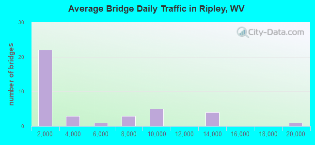
- 161,229Total average daily traffic
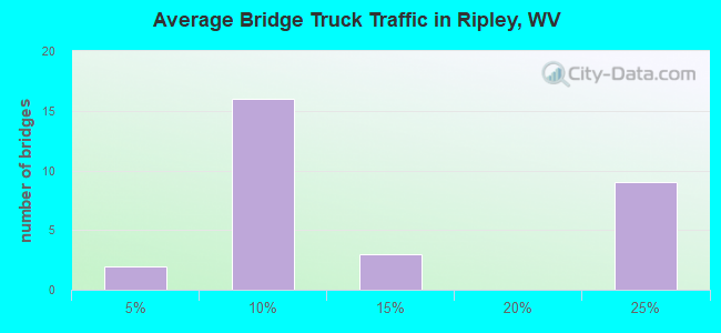
- 27,312Total average daily truck traffic
- National Bridge Inventory (NBI) Registered Bridges for Ripley
- No street view available for this location
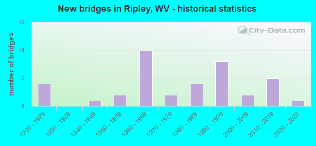
- New bridges - historical statistics
- 41920-1929
- 11940-1949
- 21950-1959
- 101960-1969
- 21970-1979
- 41980-1989
- 81990-1999
- 22000-2009
- 52010-2019
- 12020-2022
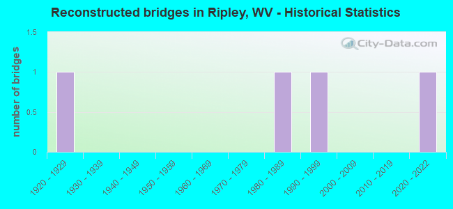
- Reconstructed bridges - Historical Statistics
- 11920-1929
- 01930-1939
- 01940-1949
- 01950-1959
- 01960-1969
- 01970-1979
- 11980-1989
- 11990-1999
- 02000-2009
- 02010-2019
- 12020-2022
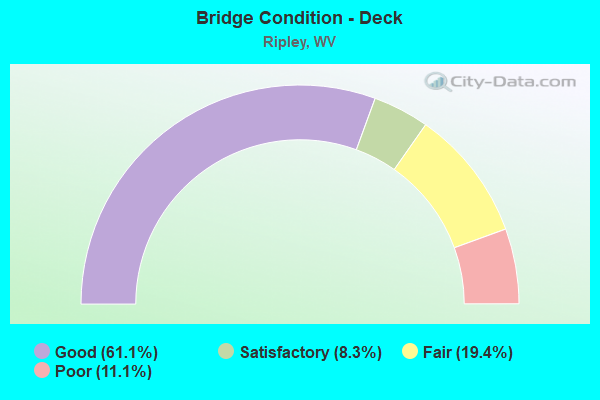
- Bridge Condition - Deck
- 61.1%Good
- 8.3%Satisfactory
- 19.4%Fair
- 11.1%Poor
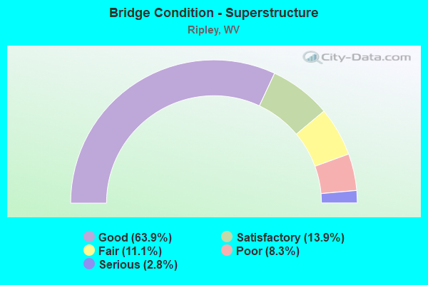
- Bridge Condition - Superstructure
- 63.9%Good
- 13.9%Satisfactory
- 11.1%Fair
- 8.3%Poor
- 2.8%Serious
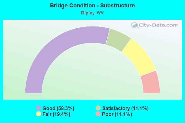
- Bridge Condition - Substructure
- 58.3%Good
- 11.1%Satisfactory
- 19.4%Fair
- 11.1%Poor
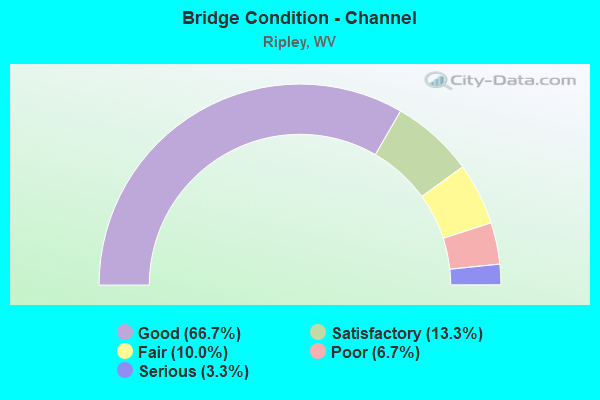
- Bridge Condition - Channel
- 66.7%Good
- 13.3%Satisfactory
- 10.0%Fair
- 6.7%Poor
- 3.3%Serious
Find on map >> Show street view
Structure Number: 18A016, Location: 0.34 MI. S. OF CR 5/7 (Lat: 38.826861, Lng: -81.728511), Route carried "on" structure: County highway 510, Year Built: 1988, Status: Open, Structure Length: 1.33m (4.36ft), Average Daily Traffic: 211 (year 2017), Truck Traffic: 12%, Average Future Daily Traffic: 287 (year 2037), Design Load: HS 20, Features Intersected: CLAYLICK RUN, Facility Carried by Structure: COUNTY ROUTE 5/10
Minimum Vertical Clearance: 30+ m (98+ ft), Kilometerpoint: 0.740, Lanes on structure: 2, Owner: State Highway Agency, Approaching Roadway Width: 7.0m (23.0ft), Material/Design: Prestressed concrete, Design/Construction: Box Beam or Girders - Multiple, Number Of Spans In Main Unit: 1, Length of Maximum Span: 13.0m (42.7ft), Curb-To-Curb Width: 7.1m (23.3ft), Out-to-Out Width: 7.4m (24.3ft)
Condition: Deck: Good, Superstructure: Good, Substructure: Good, Channel: Good, Operating Rating: 88.9 metric tons, Method Used To Determine Operating Rating: Load Factor (LF), Inventory Rating: 55.3 metric tons, Method Used To Determine Inventory Rating: Load Factor (LF), Structural Evaluation: Better than present minimum criteria, Deck Geometry: Meets minimum limits, Waterway Adequacy: Better than present minimum criteria, Approach Roadway Alignment: Equal to present minimum criteria, Length Of Structure Improvement: 1.34m (4.40ft), Designated Inspection Frequency: Every 48 months, Inspection Date: January 2019, Bridge Improvement Cost: $650,000, Roadway Improvement Cost: $50,000, Total Project Cost: $700,000 ( Estimate for 2015), Deck Structure Type: Other, Wearing Surface/Protective System: Wearing Surface: Monolithic Concrete, Deck Protection: Epoxy Coated Reinforcing
Find on map >> Show street view
Structure Number: 18A053, Location: 0.09 M SOUTH OF CR 21/26 (Lat: 38.775881, Lng: -81.724131), Route carried "on" structure: County highway 15, Year Built: 1963, Status: Posted for load, Structure Length: 7.98m (26.18ft), Average Daily Traffic: 350 (year 2018), Truck Traffic: 7%, Average Future Daily Traffic: 417 (year 2038), Design Load: HS 15, Features Intersected: Branch of Cox Fk & I-77
Minimum Vertical Clearance: 30+ m (98+ ft), Kilometerpoint: 15.289, Lanes on structure: 2, Lanes under structure: 4, Owner: State Highway Agency, Approaching Roadway Width: 7.9m (25.9ft), Material/Design: Steel continuous, Design/Construction: Stringer/Multi-beam, Number Of Spans In Main Unit: 1, Number Of Approach Spans: 4, Length of Maximum Span: 18.1m (59.4ft), Curb or Sidewalk Widths: Left: 0.5m (1.6ft), Right: 0.5m (1.6ft), Curb-To-Curb Width: 6.7m (22.0ft), Out-to-Out Width: 8.2m (26.9ft)
Condition: Deck: Good, Superstructure: Good, Substructure: Good, Channel: Good, Operating Rating: 49.9 metric tons, Method Used To Determine Operating Rating: Load Factor (LF), Inventory Rating: 29.9 metric tons, Method Used To Determine Inventory Rating: Load Factor (LF), Structural Evaluation: Better than present minimum criteria, Deck Geometry: Meets minimum limits, Underclear: Somewhat better than minimum adequacy, Waterway Adequacy: Superior to present desirable criteria, Approach Roadway Alignment: Somewhat better than minimum adequacy, Bridge Posting: Required (Relationship of Operating Rating to Maximum Legal Load: 0.1 - 9.9% below), Length Of Structure Improvement: 7.92m (25.98ft), Designated Inspection Frequency: Every 24 months, Inspection Date: July 2020, Bridge Improvement Cost: $750,000, Total Project Cost: $750,000, Deck Structure Type: Concrete Cast-file-Place, Wearing Surface/Protective System: Wearing Surface: Monolithic Concrete
Find on map >> Show street view
Structure Number: 18A073, Location: 0.02 MI. N. CR. 21/22 (Lat: 38.824319, Lng: -81.707161), Route carried "on" structure: County highway 21, Year Built: 1925, Status: Posted for load, Structure Length: 3.26m (10.70ft), Average Daily Traffic: 6,400 (year 2018), Truck Traffic: 7%, Average Future Daily Traffic: 8,000 (year 2038), Design Load: HS 15, Features Intersected: SYCAMORE CREEK
Minimum Vertical Clearance: 30+ m (98+ ft), Kilometerpoint: 34.617, Lanes on structure: 2, Owner: State Highway Agency, Approaching Roadway Width: 10.4m (34.1ft), Skew: 3 degrees, Material/Design: Concrete, Design/Construction: Tee Beam, Number Of Spans In Main Unit: 2, Length of Maximum Span: 15.8m (51.8ft), Curb or Sidewalk Widths: Left: 1.2m (3.9ft), Right: 1.2m (3.9ft), Curb-To-Curb Width: 12.2m (40.0ft), Out-to-Out Width: 15.2m (49.9ft)
Condition: Deck: Poor, Superstructure: Serious, Substructure: Poor, Channel: Poor, Operating Rating: 36.3 metric tons, Method Used To Determine Operating Rating: Load Factor (LF), Inventory Rating: 21.8 metric tons, Method Used To Determine Inventory Rating: Load Factor (LF), Structural Evaluation: High priority of corrective action, Deck Geometry: Somewhat better than minimum adequacy, Waterway Adequacy: Equal to present minimum criteria, Approach Roadway Alignment: Better than present minimum criteria, Bridge Posting: Required (Relationship of Operating Rating to Maximum Legal Load: 0.1 - 9.9% below), Length Of Structure Improvement: 6.40m (21.00ft), Designated Inspection Frequency: Every 24 months, Inspection Date: March 2021, Bridge Improvement Cost: $1,000,000, Roadway Improvement Cost: $500,000, Total Project Cost: $1,500,000 ( Estimate for 2014), Deck Structure Type: Concrete Cast-file-Place, Wearing Surface/Protective System: Wearing Surface: Bituminous
Find on map >> Show street view
Structure Number: 18A074, Location: 0.06 MI SOUTH OF CR 21/20 (Lat: 38.844600, Lng: -81.699631), Route carried "on" structure: County highway 21, Year Built: 1925, Year Reconstructed: 1932, Status: Open, Structure Length: 1.73m (5.68ft), Average Daily Traffic: 3,800 (year 2019), Truck Traffic: 6%, Average Future Daily Traffic: 5,510 (year 2039), Features Intersected: LEFT FORK SYCAMORE CK
Minimum Vertical Clearance: 30+ m (98+ ft), Kilometerpoint: 37.015, Lanes on structure: 2, Owner: State Highway Agency, Approaching Roadway Width: 10.7m (35.1ft), Skew: 3 degrees, Material/Design: Concrete, Design/Construction: Slab, Number Of Spans In Main Unit: 2, Length of Maximum Span: 8.0m (26.2ft), Curb or Sidewalk Widths: Left: 0.1m (0.3ft), Right: 0.1m (0.3ft), Curb-To-Curb Width: 9.7m (31.8ft), Out-to-Out Width: 10.1m (33.1ft)
Condition: Deck: Good, Superstructure: Good, Substructure: Fair, Channel: Fair, Operating Rating: 63.5 metric tons, Method Used To Determine Operating Rating: Field evaluation and documented engineering judgment, Inventory Rating: 29.0 metric tons, Method Used To Determine Inventory Rating: Field evaluation and documented engineering judgment, Structural Evaluation: Somewhat better than minimum adequacy, Deck Geometry: Meets minimum limits, Waterway Adequacy: Equal to present minimum criteria, Approach Roadway Alignment: Better than present minimum criteria, Length Of Structure Improvement: 1.74m (5.71ft), Designated Inspection Frequency: Every 24 months, Underwater Inspection Frequency: Every 60 months, Inspection Date: July 2021, Underwater Inspection Date: June 2020, Bridge Improvement Cost: $350,000, Roadway Improvement Cost: $50,000, Total Project Cost: $400,000, Deck Structure Type: Concrete Cast-file-Place, Wearing Surface/Protective System: Wearing Surface: Bituminous
Find on map >> Show street view
Structure Number: 18A075, Location: 0.64 MI. S. CR.12 (Lat: 38.878939, Lng: -81.689239), Route carried "on" structure: County highway 21, Year Built: 1925, Status: Open, Structure Length: 1.03m (3.38ft), Average Daily Traffic: 3,900 (year 2018), Truck Traffic: 7%, Average Future Daily Traffic: 4,875 (year 2038), Features Intersected: MUD RUN
Minimum Vertical Clearance: 30+ m (98+ ft), Kilometerpoint: 41.618, Lanes on structure: 2, Owner: State Highway Agency, Approaching Roadway Width: 9.8m (32.2ft), Skew: 4 degrees, Material/Design: Concrete, Design/Construction: Slab, Number Of Spans In Main Unit: 1, Length of Maximum Span: 9.7m (31.8ft), Curb or Sidewalk Widths: Left: 0.1m (0.3ft), Right: 0.1m (0.3ft), Curb-To-Curb Width: 9.3m (30.5ft), Out-to-Out Width: 10.1m (33.1ft)
Condition: Deck: Fair, Superstructure: Fair, Substructure: Fair, Channel: Satisfactory, Operating Rating: 63.5 metric tons, Method Used To Determine Operating Rating: Field evaluation and documented engineering judgment, Inventory Rating: 29.0 metric tons, Method Used To Determine Inventory Rating: Field evaluation and documented engineering judgment, Structural Evaluation: Somewhat better than minimum adequacy, Deck Geometry: Meets minimum limits, Waterway Adequacy: Equal to present minimum criteria, Approach Roadway Alignment: Equal to present desirable criteria, Length Of Structure Improvement: 1.04m (3.41ft), Designated Inspection Frequency: Every 24 months, Inspection Date: October 2020, Bridge Improvement Cost: $1,000,000, Roadway Improvement Cost: $2,000,000, Total Project Cost: $3,000,000, Deck Structure Type: Concrete Cast-file-Place, Wearing Surface/Protective System: Wearing Surface: Bituminous
Find on map >> Show street view
Structure Number: 18A088, Location: 0.01 M SOUTH OF C.R. 5/13 (Lat: 38.831681, Lng: -81.672900), Route carried "on" structure: County highway 2122, Year Built: 1996, Status: Open, Structure Length: 1.51m (4.95ft), Average Daily Traffic: 650 (year 2018), Truck Traffic: 6%, Average Future Daily Traffic: 774 (year 2038), Design Load: HS 25 or greater, Features Intersected: SYCAMORE CREEK, Facility Carried by Structure: COUNTY ROUTE 21/22
Minimum Vertical Clearance: 30+ m (98+ ft), Kilometerpoint: 3.573, Lanes on structure: 2, Owner: State Highway Agency, Approaching Roadway Width: 7.0m (23.0ft), Material/Design: Prestressed concrete, Design/Construction: Box Beam or Girders - Multiple, Number Of Spans In Main Unit: 1, Length of Maximum Span: 14.1m (46.3ft), Curb-To-Curb Width: 7.2m (23.6ft), Out-to-Out Width: 7.5m (24.6ft)
Condition: Deck: Good, Superstructure: Good, Substructure: Good, Channel: Good, Operating Rating: 61.7 metric tons, Method Used To Determine Operating Rating: Load Factor (LF), Inventory Rating: 37.2 metric tons, Method Used To Determine Inventory Rating: Load Factor (LF), Structural Evaluation: Better than present minimum criteria, Deck Geometry: Meets minimum limits, Waterway Adequacy: Better than present minimum criteria, Approach Roadway Alignment: Somewhat better than minimum adequacy, Designated Inspection Frequency: Every 48 months, Inspection Date: Febuary 2021, Deck Structure Type: Other, Wearing Surface/Protective System: Wearing Surface: Bituminous, Deck Protection: Epoxy Coated Reinforcing
Find on map >> Show street view
Structure Number: 18A089, Location: 0.09 MI. S. OF CR. 21/39 (Lat: 38.836061, Lng: -81.672731), Route carried "on" structure: County highway 2122, Year Built: 1977, Status: Open, Structure Length: 1.32m (4.33ft), Average Daily Traffic: 650 (year 2018), Truck Traffic: 6%, Average Future Daily Traffic: 774 (year 2038), Design Load: HS 20+Mod, Features Intersected: SYCAMORE CREEK, Facility Carried by Structure: COUNTY ROAD 21/22
Minimum Vertical Clearance: 30+ m (98+ ft), Kilometerpoint: 5.246, Lanes on structure: 2, Owner: State Highway Agency, Approaching Roadway Width: 4.3m (14.1ft), Skew: 2 degrees, Material/Design: Steel, Design/Construction: Stringer/Multi-beam, Number Of Spans In Main Unit: 1, Length of Maximum Span: 11.8m (38.7ft), Curb-To-Curb Width: 6.0m (19.7ft), Out-to-Out Width: 6.1m (20.0ft)
Condition: Deck: Good, Superstructure: Good, Substructure: Good, Channel: Good, Operating Rating: 82.5 metric tons, Method Used To Determine Operating Rating: Load Factor (LF), Inventory Rating: 49.0 metric tons, Method Used To Determine Inventory Rating: Load Factor (LF), Structural Evaluation: Better than present minimum criteria, Deck Geometry: High priority of replacement, Waterway Adequacy: Equal to present minimum criteria, Approach Roadway Alignment: Meets minimum limits, Length Of Structure Improvement: 2.44m (8.01ft), Designated Inspection Frequency: Every 24 months, Inspection Date: October 2020, Bridge Improvement Cost: $350,000, Roadway Improvement Cost: $150,000, Total Project Cost: $500,000, Deck Structure Type: Wood or Timber
Find on map >> Show street view
Structure Number: 18A091, Location: 0.04 MILE SOUTH OF CR 21 (Lat: 38.753081, Lng: -81.689089), Route carried "on" structure: County highway 2127, Year Built: 1994, Status: Open, Structure Length: 1.45m (4.76ft), Average Daily Traffic: 81 (year 2017), Average Future Daily Traffic: 110 (year 2037), Design Load: HS 25 or greater, Features Intersected: GRASSLICK RUN, Facility Carried by Structure: COUNTY ROUTE 21/27
Minimum Vertical Clearance: 30+ m (98+ ft), Kilometerpoint: 7.773, Lanes on structure: 2, Owner: State Highway Agency, Approaching Roadway Width: 4.9m (16.1ft), Material/Design: Prestressed concrete, Design/Construction: Box Beam or Girders - Multiple, Number Of Spans In Main Unit: 1, Length of Maximum Span: 14.0m (45.9ft), Curb-To-Curb Width: 6.4m (21.0ft), Out-to-Out Width: 6.5m (21.3ft)
Condition: Deck: Good, Superstructure: Good, Substructure: Good, Channel: Good, Operating Rating: 88.9 metric tons, Method Used To Determine Operating Rating: Load Factor (LF), Inventory Rating: 60.8 metric tons, Method Used To Determine Inventory Rating: Load Factor (LF), Structural Evaluation: Better than present minimum criteria, Deck Geometry: Somewhat better than minimum adequacy, Waterway Adequacy: Equal to present minimum criteria, Approach Roadway Alignment: Equal to present desirable criteria, Length Of Structure Improvement: 1.46m (4.79ft), Designated Inspection Frequency: Every 48 months, Inspection Date: January 2019, Bridge Improvement Cost: $500,000, Roadway Improvement Cost: $50,000, Total Project Cost: $550,000 ( Estimate for 2015), Deck Structure Type: Other, Wearing Surface/Protective System: Wearing Surface: Monolithic Concrete, Deck Protection: Epoxy Coated Reinforcing
Find on map >> Show street view
Structure Number: 18A108, Location: 1.03 MILE SOUTH OF CR 21 (Lat: 38.799719, Lng: -81.692019), Route carried "on" structure: County highway 25, Year Built: 1922, Year Reconstructed: 1987, Status: Posted for load, Structure Length: 3.14m (10.30ft), Average Daily Traffic: 2,400 (year 2019), Truck Traffic: 7%, Average Future Daily Traffic: 3,480 (year 2039), Design Load: HS 20, Features Intersected: MILL CREEK
Minimum Vertical Clearance: 4.42m (14.50ft), Kilometerpoint: 1.658, Lanes on structure: 2, Owner: State Highway Agency, Approaching Roadway Width: 6.1m (20.0ft), Material/Design: Steel, Design/Construction: Truss - Thru, Number Of Spans In Main Unit: 1, Length of Maximum Span: 29.9m (98.1ft), Curb-To-Curb Width: 5.6m (18.4ft), Out-to-Out Width: 5.9m (19.4ft)
Condition: Deck: Poor, Superstructure: Poor, Substructure: Fair, Channel: Good, Operating Rating: 46.3 metric tons, Method Used To Determine Operating Rating: Load Factor (LF), Inventory Rating: 29.0 metric tons, Method Used To Determine Inventory Rating: Load Factor (LF), Structural Evaluation: Meets minimum limits, Deck Geometry: High priority of replacement, Waterway Adequacy: Equal to present minimum criteria, Approach Roadway Alignment: Somewhat better than minimum adequacy, Bridge Posting: Required (Relationship of Operating Rating to Maximum Legal Load: 0.1 - 9.9% below), Length Of Structure Improvement: 5.64m (18.50ft), Designated Inspection Frequency: Every 24 months, Critical Feature Inspection Frequency: Every 24 months, Inspection Date: August 2021, Critical Feature Inspection Date: August 2021, Bridge Improvement Cost: $671,000, Roadway Improvement Cost: $649,000, Total Project Cost: $1,320,000, Deck Structure Type: Closed Grating, Wearing Surface/Protective System: Wearing Surface: Other
Find on map >> Show street view
Structure Number: 18A113, Location: 1.05 MILE EAST OF US 33 (Lat: 38.806450, Lng: -81.636139), Route carried "on" structure: County highway 26, Year Built: 1994, Status: Open, Structure Length: 2.91m (9.55ft), Average Daily Traffic: 1,000 (year 2018), Truck Traffic: 7%, Average Future Daily Traffic: 1,260 (year 2038), Design Load: HS 25 or greater, Features Intersected: LITTLE MILL CREEK
Minimum Vertical Clearance: 30+ m (98+ ft), Kilometerpoint: 1.690, Lanes on structure: 2, Owner: State Highway Agency, Approaching Roadway Width: 8.2m (26.9ft), Material/Design: Prestressed concrete, Design/Construction: Box Beam or Girders - Multiple, Number Of Spans In Main Unit: 1, Length of Maximum Span: 28.7m (94.2ft), Curb-To-Curb Width: 8.1m (26.6ft), Out-to-Out Width: 8.5m (27.9ft)
Condition: Deck: Good, Superstructure: Good, Substructure: Good, Channel: Good, Operating Rating: 88.9 metric tons, Method Used To Determine Operating Rating: Load Factor (LF), Inventory Rating: 69.8 metric tons, Method Used To Determine Inventory Rating: Load Factor (LF), Structural Evaluation: Better than present minimum criteria, Deck Geometry: Somewhat better than minimum adequacy, Waterway Adequacy: Better than present minimum criteria, Approach Roadway Alignment: Equal to present desirable criteria, Length Of Structure Improvement: 2.93m (9.61ft), Designated Inspection Frequency: Every 48 months, Inspection Date: May 2020, Bridge Improvement Cost: $700,000, Roadway Improvement Cost: $150,000, Total Project Cost: $850,000 ( Estimate for 2016), Deck Structure Type: Other, Wearing Surface/Protective System: Wearing Surface: Bituminous, Deck Protection: Epoxy Coated Reinforcing
Find on map >> Show street view
Structure Number: 18A117, Location: 0.03 MI WEST OF CR 30/5 (Lat: 38.793950, Lng: -81.770911), Route carried "on" structure: County highway 30, Year Built: 1971, Status: Posted for load, Structure Length: 1.98m (6.50ft), Average Daily Traffic: 750 (year 2018), Truck Traffic: 7%, Average Future Daily Traffic: 945 (year 2038), Features Intersected: PARCHMENT CREEK
Minimum Vertical Clearance: 30+ m (98+ ft), Kilometerpoint: 3.154, Lanes on structure: 1, Owner: State Highway Agency, Approaching Roadway Width: 4.6m (15.1ft), Material/Design: Steel, Design/Construction: Stringer/Multi-beam, Number Of Spans In Main Unit: 1, Length of Maximum Span: 19.2m (63.0ft), Curb-To-Curb Width: 3.8m (12.5ft), Out-to-Out Width: 4.3m (14.1ft)
Condition: Deck: Poor, Superstructure: Poor, Substructure: Poor, Channel: Serious, Operating Rating: 25.4 metric tons, Method Used To Determine Operating Rating: Load Factor (LF), Inventory Rating: 14.5 metric tons, Method Used To Determine Inventory Rating: Load Factor (LF), Structural Evaluation: Meets minimum limits, Deck Geometry: High priority of replacement, Waterway Adequacy: Better than present minimum criteria, Approach Roadway Alignment: Somewhat better than minimum adequacy, Bridge Posting: Required (Relationship of Operating Rating to Maximum Legal Load: > 39.9% below), Length Of Structure Improvement: 2.29m (7.51ft), Designated Inspection Frequency: Every 24 months, Underwater Inspection Frequency: Every 60 months, Inspection Date: March 2020, Underwater Inspection Date: September 2018, Bridge Improvement Cost: $1,000,000, Roadway Improvement Cost: $500,000, Total Project Cost: $1,500,000 ( Estimate for 2016), Deck Structure Type: Wood or Timber
Find on map >> Show street view
Structure Number: 18A118, Location: 0.01 MILE WEST CR 5/25 (Lat: 38.782681, Lng: -81.748119), Route carried "on" structure: County highway 30, Year Built: 1950, Status: Open, Structure Length: 0.81m (2.66ft), Average Daily Traffic: 200 (year 2019), Truck Traffic: 6%, Average Future Daily Traffic: 290 (year 2039), Design Load: HS 20, Features Intersected: GRASS RUN
Minimum Vertical Clearance: 30+ m (98+ ft), Kilometerpoint: 6.196, Lanes on structure: 2, Owner: State Highway Agency, Approaching Roadway Width: 7.3m (24.0ft), Material/Design: Prestressed concrete, Design/Construction: Channel Beam, Number Of Spans In Main Unit: 1, Length of Maximum Span: 6.9m (22.6ft), Curb-To-Curb Width: 6.8m (22.3ft), Out-to-Out Width: 7.3m (24.0ft)
Condition: Deck: Fair, Superstructure: Fair, Substructure: Fair, Channel: Fair, Operating Rating: 71.7 metric tons, Method Used To Determine Operating Rating: Field evaluation and documented engineering judgment, Inventory Rating: 32.7 metric tons, Method Used To Determine Inventory Rating: Field evaluation and documented engineering judgment, Structural Evaluation: Somewhat better than minimum adequacy, Deck Geometry: Meets minimum limits, Waterway Adequacy: Better than present minimum criteria, Approach Roadway Alignment: Better than present minimum criteria, Length Of Structure Improvement: 0.79m (2.59ft), Designated Inspection Frequency: Every 24 months, Inspection Date: November 2021, Bridge Improvement Cost: $450,000, Roadway Improvement Cost: $150,000, Total Project Cost: $600,000, Deck Structure Type: Other, Wearing Surface/Protective System: Wearing Surface: Bituminous
Find on map >> Show street view
Structure Number: 18A124, Location: 0.30 M SOUTH OF CR 32 (Lat: 38.784081, Lng: -81.773650), Route carried "on" structure: County highway 321, Year Built: 1980, Status: Posted for load, Structure Length: 1.02m (3.35ft), Average Daily Traffic: 10 (year 2018), Average Future Daily Traffic: 12 (year 2038), Design Load: H 20, Features Intersected: ROUNDKNOB RUN, Facility Carried by Structure: COUNTY ROUTE 32/1
Minimum Vertical Clearance: 30+ m (98+ ft), Kilometerpoint: 4.168, Lanes on structure: 2, Owner: State Highway Agency, Approaching Roadway Width: 3.4m (11.2ft), Material/Design: Steel, Design/Construction: Stringer/Multi-beam, Number Of Spans In Main Unit: 1, Length of Maximum Span: 9.8m (32.2ft), Curb-To-Curb Width: 5.3m (17.4ft), Out-to-Out Width: 5.5m (18.0ft)
Condition: Deck: Fair, Superstructure: Poor, Substructure: Satisfactory, Channel: Fair, Operating Rating: 27.2 metric tons, Method Used To Determine Operating Rating: Load Factor (LF), Inventory Rating: 16.3 metric tons, Method Used To Determine Inventory Rating: Load Factor (LF), Structural Evaluation: Meets minimum limits, Deck Geometry: High priority of corrective action, Waterway Adequacy: Somewhat better than minimum adequacy, Approach Roadway Alignment: Equal to present minimum criteria, Bridge Posting: Required (Relationship of Operating Rating to Maximum Legal Load: > 39.9% below), Length Of Structure Improvement: 1.01m (3.31ft), Designated Inspection Frequency: Every 24 months, Inspection Date: January 2020, Bridge Improvement Cost: $20,000, Roadway Improvement Cost: $1,000, Total Project Cost: $21,000, Deck Structure Type: Wood or Timber, Wearing Surface/Protective System: Wearing Surface: Wood or Timber
Find on map >> Show street view
Structure Number: 18A127, Location: 0.13 MI. W. OF CR. 5/9 (Lat: 38.820611, Lng: -81.726189), Route carried "on" structure: US 33, Year Built: 1967, Status: Open, Structure Length: 4.95m (16.24ft), Average Daily Traffic: 6,200 (year 2019), Truck Traffic: 11%, Average Future Daily Traffic: 7,936 (year 2039), Design Load: HS 20, Features Intersected: MILL CREEK
Minimum Vertical Clearance: 30+ m (98+ ft), Kilometerpoint: 18.475, Lanes on structure: 2, Base Highway Network: Yes, Owner: State Highway Agency, Approaching Roadway Width: 10.4m (34.1ft), Material/Design: Steel continuous, Design/Construction: Stringer/Multi-beam, Number Of Spans In Main Unit: 1, Number Of Approach Spans: 2, Length of Maximum Span: 20.1m (65.9ft), Curb or Sidewalk Widths: Left: 0.9m (3.0ft), Right: 0.9m (3.0ft), Curb-To-Curb Width: 8.5m (27.9ft), Out-to-Out Width: 11.0m (36.1ft)
Condition: Deck: Fair, Superstructure: Fair, Substructure: Fair, Channel: Good, Operating Rating: 65.3 metric tons, Method Used To Determine Operating Rating: Load Factor (LF), Inventory Rating: 39.0 metric tons, Method Used To Determine Inventory Rating: Load Factor (LF), Structural Evaluation: Somewhat better than minimum adequacy, Deck Geometry: High priority of replacement, Waterway Adequacy: Equal to present desirable criteria, Approach Roadway Alignment: Equal to present desirable criteria, Length Of Structure Improvement: 4.97m (16.31ft), Designated Inspection Frequency: Every 24 months, Inspection Date: June 2021, Bridge Improvement Cost: $1,200,000, Roadway Improvement Cost: $200,000, Total Project Cost: $1,400,000, Deck Structure Type: Concrete Cast-file-Place, Wearing Surface/Protective System: Wearing Surface: Latex Concrete
Find on map >> Show street view
Structure Number: 18A162, Location: 5.45 MI N OF CR 21 (Lat: 38.820081, Lng: -81.727700), Route carried "on" structure: Interstate 77, Year Built: 1964, Status: Open, Structure Length: 4.01m (13.16ft), Average Daily Traffic: 9,550 (year 2019), Truck Traffic: 23%, Average Future Daily Traffic: 13,657 (year 2039), Design Load: HS 20+Mod, Features Intersected: US Route 33
Minimum Vertical Clearance: 30+ m (98+ ft), Kilometerpoint: 221.912, Lanes on structure: 2, Lanes under structure: 3, Base Highway Network: Yes, Owner: State Highway Agency, Approaching Roadway Width: 11.3m (37.1ft), Skew: 2 degrees, Material/Design: Steel continuous, Design/Construction: Stringer/Multi-beam, Number Of Spans In Main Unit: 1, Number Of Approach Spans: 2, Length of Maximum Span: 19.7m (64.6ft), Curb-To-Curb Width: 11.3m (37.1ft), Out-to-Out Width: 12.8m (42.0ft)
Condition: Deck: Fair, Superstructure: Satisfactory, Substructure: Fair, Operating Rating: 68.9 metric tons, Method Used To Determine Operating Rating: Load Factor (LF), Inventory Rating: 41.7 metric tons, Method Used To Determine Inventory Rating: Load Factor (LF), Structural Evaluation: Somewhat better than minimum adequacy, Deck Geometry: Somewhat better than minimum adequacy, Underclear: Meets minimum limits, Approach Roadway Alignment: Better than present minimum criteria, Length Of Structure Improvement: 3.99m (13.09ft), Designated Inspection Frequency: Every 24 months, Other Special Inspection Frequency: Every 12 months, Inspection Date: October 2020, Other Special Inspection Date: October 2021, Bridge Improvement Cost: $2,000,000, Roadway Improvement Cost: $500,000, Total Project Cost: $2,500,000 ( Estimate for 2015), Deck Structure Type: Concrete Cast-file-Place, Wearing Surface/Protective System: Wearing Surface: Latex Concrete
Find on map >> Show street view
Structure Number: 18A163, Location: 5.49 MI N OF CR 21 (Lat: 38.819989, Lng: -81.727961), Route carried "on" structure: Interstate 77, Year Built: 1964, Status: Open, Structure Length: 4.01m (13.16ft), Average Daily Traffic: 12,850 (year 2018), Truck Traffic: 23%, Average Future Daily Traffic: 17,605 (year 2038), Design Load: HS 20+Mod, Features Intersected: US Route 33
Minimum Vertical Clearance: 30+ m (98+ ft), Kilometerpoint: 221.912, Lanes on structure: 2, Lanes under structure: 3, Base Highway Network: Yes, Owner: State Highway Agency, Approaching Roadway Width: 11.0m (36.1ft), Skew: 2 degrees, Material/Design: Steel continuous, Design/Construction: Stringer/Multi-beam, Number Of Spans In Main Unit: 1, Number Of Approach Spans: 2, Length of Maximum Span: 19.6m (64.3ft), Curb-To-Curb Width: 11.3m (37.1ft), Out-to-Out Width: 12.8m (42.0ft)
Condition: Deck: Fair, Superstructure: Satisfactory, Substructure: Fair, Operating Rating: 68.9 metric tons, Method Used To Determine Operating Rating: Load Factor (LF), Inventory Rating: 41.7 metric tons, Method Used To Determine Inventory Rating: Load Factor (LF), Structural Evaluation: Somewhat better than minimum adequacy, Deck Geometry: Somewhat better than minimum adequacy, Underclear: Meets minimum limits, Approach Roadway Alignment: Equal to present desirable criteria, Length Of Structure Improvement: 3.99m (13.09ft), Designated Inspection Frequency: Every 24 months, Other Special Inspection Frequency: Every 24 months, Inspection Date: October 2020, Other Special Inspection Date: October 2020, Bridge Improvement Cost: $2,000,000, Roadway Improvement Cost: $500,000, Total Project Cost: $2,500,000 ( Estimate for 2015), Deck Structure Type: Concrete Cast-file-Place, Wearing Surface/Protective System: Wearing Surface: Latex Concrete
Find on map >> Show street view
Structure Number: 18A164, Location: 3.04 MILE NORTH OF US 33 (Lat: 38.859481, Lng: -81.735169), Route carried "on" structure: Interstate 77, Year Built: 1965, Status: Open, Structure Length: 3.40m (11.15ft), Average Daily Traffic: 9,700 (year 2018), Truck Traffic: 23%, Average Future Daily Traffic: 13,289 (year 2038), Design Load: HS 20+Mod, Features Intersected: 12/5
Minimum Vertical Clearance: 30+ m (98+ ft), Kilometerpoint: 226.789, Lanes on structure: 2, Lanes under structure: 2, Base Highway Network: Yes, Owner: State Highway Agency, Approaching Roadway Width: 11.3m (37.1ft), Material/Design: Steel continuous, Design/Construction: Stringer/Multi-beam, Number Of Spans In Main Unit: 1, Number Of Approach Spans: 2, Length of Maximum Span: 14.6m (47.9ft), Curb-To-Curb Width: 11.3m (37.1ft), Out-to-Out Width: 12.4m (40.7ft)
Condition: Deck: Satisfactory, Superstructure: Satisfactory, Substructure: Satisfactory, Operating Rating: 73.5 metric tons, Method Used To Determine Operating Rating: Load Factor (LF), Inventory Rating: 44.4 metric tons, Method Used To Determine Inventory Rating: Load Factor (LF), Structural Evaluation: Equal to present minimum criteria, Deck Geometry: Somewhat better than minimum adequacy, Underclear: Meets minimum limits, Approach Roadway Alignment: Equal to present desirable criteria, Length Of Structure Improvement: 3.41m (11.19ft), Designated Inspection Frequency: Every 24 months, Inspection Date: October 2020, Bridge Improvement Cost: $2,000,000, Roadway Improvement Cost: $200,000, Total Project Cost: $2,200,000 ( Estimate for 2015), Deck Structure Type: Concrete Cast-file-Place, Wearing Surface/Protective System: Wearing Surface: Latex Concrete
Find on map >> Show street view
Structure Number: 18A165, Location: 3.04 MILE NORTH OF US 33 (Lat: 38.859439, Lng: -81.735411), Route carried "on" structure: Interstate 77, Year Built: 1965, Status: Open, Structure Length: 3.40m (11.15ft), Average Daily Traffic: 9,700 (year 2018), Truck Traffic: 23%, Average Future Daily Traffic: 13,289 (year 2038), Design Load: HS 20+Mod, Features Intersected: 12/5
Minimum Vertical Clearance: 30+ m (98+ ft), Kilometerpoint: 226.789, Lanes on structure: 2, Lanes under structure: 2, Base Highway Network: Yes, Owner: State Highway Agency, Approaching Roadway Width: 11.3m (37.1ft), Material/Design: Steel continuous, Design/Construction: Stringer/Multi-beam, Number Of Spans In Main Unit: 1, Number Of Approach Spans: 2, Length of Maximum Span: 14.6m (47.9ft), Curb-To-Curb Width: 11.3m (37.1ft), Out-to-Out Width: 12.4m (40.7ft)
Condition: Deck: Satisfactory, Superstructure: Satisfactory, Substructure: Satisfactory, Operating Rating: 73.5 metric tons, Method Used To Determine Operating Rating: Load Factor (LF), Inventory Rating: 44.4 metric tons, Method Used To Determine Inventory Rating: Load Factor (LF), Structural Evaluation: Equal to present minimum criteria, Deck Geometry: Somewhat better than minimum adequacy, Underclear: Meets minimum limits, Approach Roadway Alignment: Equal to present desirable criteria, Length Of Structure Improvement: 3.41m (11.19ft), Designated Inspection Frequency: Every 24 months, Inspection Date: October 2020, Bridge Improvement Cost: $2,000,000, Roadway Improvement Cost: $200,000, Total Project Cost: $2,200,000 ( Estimate for 2015), Deck Structure Type: Concrete Cast-file-Place, Wearing Surface/Protective System: Wearing Surface: Latex Concrete
Find on map >> Show street view
Structure Number: 18A193, Location: 0.08 M WEST OF CR 21 (Lat: 38.809469, Lng: -81.705039), Route carried "on" structure: County highway 151, Year Built: 1980, Status: Open, Structure Length: 6.13m (20.11ft), Average Daily Traffic: 100 (year 2018), Average Future Daily Traffic: 100 (year 2038), Design Load: HS 20+Mod, Features Intersected: MILL CREEK, Facility Carried by Structure: COUNTY ROUTE 15/1
Minimum Vertical Clearance: 30+ m (98+ ft), Kilometerpoint: 0.467, Lanes on structure: 2, Owner: State Highway Agency, Approaching Roadway Width: 9.1m (29.9ft), Skew: 4 degrees, Material/Design: Steel continuous, Design/Construction: Stringer/Multi-beam, Number Of Spans In Main Unit: 1, Number Of Approach Spans: 2, Length of Maximum Span: 24.1m (79.1ft), Curb or Sidewalk Widths: Left: 1.5m (4.9ft), Right: 0.0m, Curb-To-Curb Width: 7.4m (24.3ft), Out-to-Out Width: 9.8m (32.2ft)
Condition: Deck: Good, Superstructure: Good, Substructure: Good, Channel: Good, Operating Rating: 65.3 metric tons, Method Used To Determine Operating Rating: Load Factor (LF), Inventory Rating: 39.0 metric tons, Method Used To Determine Inventory Rating: Load Factor (LF), Structural Evaluation: Better than present minimum criteria, Deck Geometry: Equal to present minimum criteria, Waterway Adequacy: Equal to present desirable criteria, Approach Roadway Alignment: Better than present minimum criteria, Length Of Structure Improvement: 6.13m (20.11ft), Designated Inspection Frequency: Every 48 months, Inspection Date: April 2020, Bridge Improvement Cost: $900,000, Roadway Improvement Cost: $100,000, Total Project Cost: $1,000,000, Deck Structure Type: Concrete Cast-file-Place, Wearing Surface/Protective System: Wearing Surface: Monolithic Concrete, Deck Protection: Epoxy Coated Reinforcing
Find on map >> Show street view
Structure Number: 18A194, Location: 0.06 MI EAST OF CR 21 (Lat: 38.837181, Lng: -81.700031), Route carried "on" structure: County highway 2121, Year Built: 1981, Status: Open, Structure Length: 1.22m (4.00ft), Average Daily Traffic: 40 (year 2019), Average Future Daily Traffic: 58 (year 2039), Design Load: H 20, Features Intersected: LT FK SYCAMORE CREEK, Facility Carried by Structure: CR 21/21
Minimum Vertical Clearance: 30+ m (98+ ft), Kilometerpoint: 0.097, Lanes on structure: 2, Owner: State Highway Agency, Approaching Roadway Width: 4.3m (14.1ft), Skew: 3 degrees, Material/Design: Steel, Design/Construction: Stringer/Multi-beam, Number Of Spans In Main Unit: 1, Length of Maximum Span: 11.8m (38.7ft), Curb-To-Curb Width: 5.0m (16.4ft), Out-to-Out Width: 5.5m (18.0ft)
Condition: Deck: Poor, Superstructure: Good, Substructure: Good, Channel: Satisfactory, Operating Rating: 53.5 metric tons, Method Used To Determine Operating Rating: Load Factor (LF), Inventory Rating: 31.7 metric tons, Method Used To Determine Inventory Rating: Load Factor (LF), Structural Evaluation: Better than present minimum criteria, Deck Geometry: High priority of corrective action, Waterway Adequacy: Better than present minimum criteria, Approach Roadway Alignment: Better than present minimum criteria, Length Of Structure Improvement: 1.22m (4.00ft), Designated Inspection Frequency: Every 24 months, Inspection Date: September 2021, Bridge Improvement Cost: $15,000, Total Project Cost: $15,000 ( Estimate for 2014), Deck Structure Type: Wood or Timber, Wearing Surface/Protective System: Wearing Surface: Wood or Timber
Find on map >> Show street view
Structure Number: 18A217, Location: 0.22 MILE EAST OF WV 87 (Lat: 38.812689, Lng: -81.788089), Route carried "on" structure: County highway 30, Year Built: 1997, Status: Open, Structure Length: 1.21m (3.97ft), Average Daily Traffic: 750 (year 2018), Truck Traffic: 6%, Average Future Daily Traffic: 945 (year 2038), Design Load: HS 25 or greater, Features Intersected: ISAACS RUN
Minimum Vertical Clearance: 30+ m (98+ ft), Kilometerpoint: 0.354, Lanes on structure: 2, Owner: State Highway Agency, Approaching Roadway Width: 5.5m (18.0ft), Skew: 4 degrees, Material/Design: Prestressed concrete, Design/Construction: Box Beam or Girders - Multiple, Number Of Spans In Main Unit: 1, Length of Maximum Span: 10.4m (34.1ft), Curb-To-Curb Width: 7.2m (23.6ft), Out-to-Out Width: 7.5m (24.6ft)
Condition: Deck: Good, Superstructure: Good, Substructure: Good, Channel: Satisfactory, Operating Rating: 50.8 metric tons, Method Used To Determine Operating Rating: Load Factor (LF), Inventory Rating: 29.9 metric tons, Method Used To Determine Inventory Rating: Load Factor (LF), Structural Evaluation: Better than present minimum criteria, Deck Geometry: Meets minimum limits, Waterway Adequacy: Better than present minimum criteria, Approach Roadway Alignment: Better than present minimum criteria, Designated Inspection Frequency: Every 48 months, Inspection Date: Febuary 2021, Deck Structure Type: Other, Wearing Surface/Protective System: Wearing Surface: Monolithic Concrete, Deck Protection: Epoxy Coated Reinforcing
Find on map >> Show street view
Structure Number: 18A22, Location: 0.24 MILE N OF CR 15/6 (Lat: 38.757661, Lng: -81.737450), Route carried "on" structure: County highway 15, Year Built: 1998, Status: Open, Structure Length: 2.26m (7.41ft), Average Daily Traffic: 450 (year 2018), Truck Traffic: 7%, Average Future Daily Traffic: 567 (year 2038), Design Load: HS 25 or greater, Features Intersected: PARCHMENT CREEK
Minimum Vertical Clearance: 30+ m (98+ ft), Kilometerpoint: 12.344, Lanes on structure: 2, Owner: State Highway Agency, Approaching Roadway Width: 4.6m (15.1ft), Material/Design: Prestressed concrete, Design/Construction: Box Beam or Girders - Multiple, Number Of Spans In Main Unit: 1, Length of Maximum Span: 21.5m (70.5ft), Curb-To-Curb Width: 7.3m (24.0ft), Out-to-Out Width: 7.5m (24.6ft)
Condition: Deck: Good, Superstructure: Good, Substructure: Good, Channel: Good, Operating Rating: 78.9 metric tons, Method Used To Determine Operating Rating: Load Factor (LF), Inventory Rating: 47.2 metric tons, Method Used To Determine Inventory Rating: Load Factor (LF), Structural Evaluation: Better than present minimum criteria, Deck Geometry: Meets minimum limits, Waterway Adequacy: Equal to present minimum criteria, Approach Roadway Alignment: Equal to present desirable criteria, Length Of Structure Improvement: 2.29m (7.51ft), Designated Inspection Frequency: Every 48 months, Inspection Date: December 2020, Bridge Improvement Cost: $1,000,000, Roadway Improvement Cost: $100,000, Total Project Cost: $1,100,000, Deck Structure Type: Other, Wearing Surface/Protective System: Wearing Surface: Monolithic Concrete, Deck Protection: Epoxy Coated Reinforcing
Find on map >> Show street view
Structure Number: 18A221, Location: 0.17 MILE SOUTH OF CR 30 (Lat: 38.771061, Lng: -81.737081), Route carried "on" structure: County highway 15, Year Built: 1998, Status: Open, Structure Length: 1.66m (5.45ft), Average Daily Traffic: 422 (year 2017), Truck Traffic: 7%, Average Future Daily Traffic: 550 (year 2037), Design Load: HS 25 or greater, Features Intersected: COX FORK OF PARCHMENT CK
Minimum Vertical Clearance: 30+ m (98+ ft), Kilometerpoint: 13.905, Lanes on structure: 2, Owner: State Highway Agency, Approaching Roadway Width: 5.8m (19.0ft), Material/Design: Prestressed concrete, Design/Construction: Box Beam or Girders - Multiple, Number Of Spans In Main Unit: 1, Length of Maximum Span: 15.5m (50.9ft), Curb-To-Curb Width: 7.3m (24.0ft), Out-to-Out Width: 7.5m (24.6ft)
Condition: Deck: Good, Superstructure: Good, Substructure: Good, Channel: Good, Operating Rating: 80.7 metric tons, Method Used To Determine Operating Rating: Load Factor (LF), Inventory Rating: 49.0 metric tons, Method Used To Determine Inventory Rating: Load Factor (LF), Structural Evaluation: Better than present minimum criteria, Deck Geometry: Meets minimum limits, Waterway Adequacy: Equal to present desirable criteria, Approach Roadway Alignment: Equal to present desirable criteria, Length Of Structure Improvement: 1.68m (5.51ft), Designated Inspection Frequency: Every 48 months, Inspection Date: November 2018, Bridge Improvement Cost: $1,000,000, Roadway Improvement Cost: $300,000, Total Project Cost: $1,300,000 ( Estimate for 2014), Deck Structure Type: Other, Wearing Surface/Protective System: Wearing Surface: Monolithic Concrete, Deck Protection: Epoxy Coated Reinforcing
Find on map >> Show street view
Structure Number: 18A224, Location: 0.01 MILE EAST OF WV 87 (Lat: 38.813711, Lng: -81.790150), Route carried "on" structure: County highway 8719, Year Built: 1999, Status: Open, Structure Length: 1.51m (4.95ft), Average Daily Traffic: 20 (year 2017), Average Future Daily Traffic: 28 (year 2037), Design Load: HS 25 or greater, Features Intersected: ISAACS RUN, Facility Carried by Structure: COUNTY ROUTE 87/19
Minimum Vertical Clearance: 30+ m (98+ ft), Kilometerpoint: 0.016, Lanes on structure: 2, Owner: State Highway Agency, Approaching Roadway Width: 7.3m (24.0ft), Material/Design: Prestressed concrete, Design/Construction: Box Beam or Girders - Multiple, Number Of Spans In Main Unit: 1, Length of Maximum Span: 14.0m (45.9ft), Curb-To-Curb Width: 9.0m (29.5ft), Out-to-Out Width: 9.3m (30.5ft)
Condition: Deck: Good, Superstructure: Good, Substructure: Good, Channel: Good, Operating Rating: 78.0 metric tons, Method Used To Determine Operating Rating: Load Factor (LF), Inventory Rating: 47.2 metric tons, Method Used To Determine Inventory Rating: Load Factor (LF), Structural Evaluation: Better than present minimum criteria, Deck Geometry: Better than present minimum criteria, Waterway Adequacy: Better than present minimum criteria, Approach Roadway Alignment: Equal to present desirable criteria, Length Of Structure Improvement: 1.40m (4.59ft), Designated Inspection Frequency: Every 48 months, Inspection Date: January 2019, Bridge Improvement Cost: $600,000, Roadway Improvement Cost: $50,000, Total Project Cost: $650,000 ( Estimate for 2015), Deck Structure Type: Other, Wearing Surface/Protective System: Wearing Surface: Monolithic Concrete, Deck Protection: Epoxy Coated Reinforcing
Find on map >> Show street view
Structure Number: 18A226, Location: 0.01 MILE WEST OF CR 87/9 (Lat: 38.863331, Lng: -81.779350), Route carried "on" structure: County highway 877, Year Built: 1999, Status: Posted for load, Structure Length: 0.91m (2.99ft), Average Daily Traffic: 100 (year 2018), Average Future Daily Traffic: 119 (year 2038), Design Load: H 20, Features Intersected: LOGLICK RUN, Facility Carried by Structure: COUNTY ROUTE 87/7
Minimum Vertical Clearance: 30+ m (98+ ft), Kilometerpoint: 2.253, Lanes on structure: 2, Owner: State Highway Agency, Approaching Roadway Width: 3.4m (11.2ft), Skew: 5 degrees, Material/Design: Steel, Design/Construction: Stringer/Multi-beam, Number Of Spans In Main Unit: 1, Length of Maximum Span: 8.6m (28.2ft), Curb-To-Curb Width: 5.8m (19.0ft), Out-to-Out Width: 6.1m (20.0ft)
Condition: Deck: Good, Superstructure: Good, Substructure: Good, Channel: Poor, Operating Rating: 37.2 metric tons, Method Used To Determine Operating Rating: Load Factor (LF), Inventory Rating: 22.7 metric tons, Method Used To Determine Inventory Rating: Load Factor (LF), Structural Evaluation: Equal to present minimum criteria, Deck Geometry: Meets minimum limits, Waterway Adequacy: Equal to present minimum criteria, Approach Roadway Alignment: Equal to present desirable criteria, Bridge Posting: Required (Relationship of Operating Rating to Maximum Legal Load: 20.0 - 29.9% below), Length Of Structure Improvement: 0.91m (2.99ft), Designated Inspection Frequency: Every 24 months, Inspection Date: January 2021, Bridge Improvement Cost: $300,000, Roadway Improvement Cost: $50,000, Total Project Cost: $350,000 ( Estimate for 2017), Deck Structure Type: Corrugated Steel, Wearing Surface/Protective System: Wearing Surface: Bituminous
Find on map >> Show street view
Structure Number: 18A233, Location: 0.05 MILE EAST OF CR 15 (Lat: 38.818939, Lng: -81.715419), Route carried "on" structure: US 33, Year Built: 2003, Status: Open, Structure Length: 7.53m (24.70ft), Average Daily Traffic: 19,800 (year 2018), Truck Traffic: 11%, Average Future Daily Traffic: 26,136 (year 2038), Design Load: HS 25 or greater, Features Intersected: MILL CREEK
Minimum Vertical Clearance: 30+ m (98+ ft), Kilometerpoint: 19.489, Lanes on structure: 3, Base Highway Network: Yes, Owner: State Highway Agency, Approaching Roadway Width: 11.0m (36.1ft), Material/Design: Prestressed concrete, Design/Construction: Stringer/Multi-beam, Number Of Spans In Main Unit: 1, Number Of Approach Spans: 2, Length of Maximum Span: 33.5m (109.9ft), Curb or Sidewalk Widths: Left: 1.5m (4.9ft), Right: 1.5m (4.9ft), Curb-To-Curb Width: 11.0m (36.1ft), Out-to-Out Width: 14.6m (47.9ft)
Condition: Deck: Good, Superstructure: Good, Substructure: Good, Channel: Good, Operating Rating: 77.1 metric tons, Method Used To Determine Operating Rating: Load Factor (LF), Inventory Rating: 46.3 metric tons, Method Used To Determine Inventory Rating: Load Factor (LF), Structural Evaluation: Better than present minimum criteria, Deck Geometry: High priority of replacement, Waterway Adequacy: Equal to present minimum criteria, Approach Roadway Alignment: Equal to present desirable criteria, Length Of Structure Improvement: 7.53m (24.70ft), Designated Inspection Frequency: Every 24 months, Inspection Date: April 2020, Bridge Improvement Cost: $450,000, Roadway Improvement Cost: $50,000, Total Project Cost: $500,000 ( Estimate for 2014), Deck Structure Type: Concrete Cast-file-Place, Wearing Surface/Protective System: Wearing Surface: Monolithic Concrete, Deck Protection: Epoxy Coated Reinforcing
Find on map >> Show street view
Structure Number: 18A234, Location: 0.62 MILE SOUTH OF CR 25 (Lat: 38.801231, Lng: -81.699289), Route carried "on" structure: County highway 21, Year Built: 1949, Year Reconstructed: 2001, Status: Open, Structure Length: 5.17m (16.96ft), Average Daily Traffic: 7,600 (year 2018), Truck Traffic: 7%, Average Future Daily Traffic: 9,500 (year 2038), Design Load: HS 25 or greater, Features Intersected: MILL CREEK
Minimum Vertical Clearance: 30+ m (98+ ft), Kilometerpoint: 31.559, Lanes on structure: 2, Owner: State Highway Agency, Approaching Roadway Width: 7.3m (24.0ft), Skew: 3 degrees, Material/Design: Steel continuous, Design/Construction: Stringer/Multi-beam, Number Of Spans In Main Unit: 1, Number Of Approach Spans: 2, Length of Maximum Span: 19.8m (65.0ft), Curb-To-Curb Width: 9.8m (32.2ft), Out-to-Out Width: 10.0m (32.8ft)
Condition: Deck: Good, Superstructure: Good, Substructure: Poor, Channel: Good, Operating Rating: 53.5 metric tons, Method Used To Determine Operating Rating: Load Factor (LF), Inventory Rating: 31.7 metric tons, Method Used To Determine Inventory Rating: Load Factor (LF), Structural Evaluation: Meets minimum limits, Deck Geometry: Meets minimum limits, Waterway Adequacy: Equal to present desirable criteria, Approach Roadway Alignment: Equal to present desirable criteria, Length Of Structure Improvement: 5.18m (16.99ft), Designated Inspection Frequency: Every 24 months, Inspection Date: April 2020, Bridge Improvement Cost: $350,000, Total Project Cost: $350,000 ( Estimate for 2016), Deck Structure Type: Closed Grating, Wearing Surface/Protective System: Wearing Surface: Epoxy Overlay, Membrane: Epoxy, Deck Protection: Galvanized Reinforcing
Find on map >> Show street view
Structure Number: 18A245, Location: 0.49 MILE NORTH OF CR 21 (Lat: 38.825561, Lng: -81.698969), Route carried "on" structure: County highway 2122, Year Built: 2006, Status: Open, Structure Length: 2.25m (7.38ft), Average Daily Traffic: 650 (year 2018), Truck Traffic: 6%, Average Future Daily Traffic: 774 (year 2038), Design Load: HS 25 or greater, Features Intersected: SYCAMORE CREEK, Facility Carried by Structure: COUNTY ROUTE 21/22
Minimum Vertical Clearance: 30+ m (98+ ft), Kilometerpoint: 0.789, Lanes on structure: 2, Owner: State Highway Agency, Approaching Roadway Width: 6.1m (20.0ft), Skew: 1 degrees, Material/Design: Concrete, Design/Construction: Box Beam or Girders - Multiple, Number Of Spans In Main Unit: 1, Length of Maximum Span: 21.3m (69.9ft), Curb-To-Curb Width: 7.1m (23.3ft), Out-to-Out Width: 7.4m (24.3ft)
Condition: Deck: Satisfactory, Superstructure: Satisfactory, Substructure: Satisfactory, Channel: Satisfactory, Operating Rating: 78.0 metric tons, Method Used To Determine Operating Rating: Load Factor (LF), Inventory Rating: 47.2 metric tons, Method Used To Determine Inventory Rating: Load Factor (LF), Structural Evaluation: Equal to present minimum criteria, Deck Geometry: Meets minimum limits, Waterway Adequacy: Better than present minimum criteria, Approach Roadway Alignment: Equal to present desirable criteria, Designated Inspection Frequency: Every 48 months, Inspection Date: March 2021, Deck Structure Type: Other, Wearing Surface/Protective System: Deck Protection: Epoxy Coated Reinforcing
Find on map >> Show street view
Structure Number: 18A253, Location: 0.14 Mile West of WV 62 (Lat: 38.827939, Lng: -81.765061), Route carried "on" structure: State highway 87, Year Built: 2011, Status: Open, Structure Length: 4.86m (15.94ft), Average Daily Traffic: 4,100 (year 2019), Truck Traffic: 8%, Average Future Daily Traffic: 4,428 (year 2039), Design Load: HS 25 or greater, Features Intersected: Mill Creek
Minimum Vertical Clearance: 30+ m (98+ ft), Kilometerpoint: 8.690, Lanes on structure: 2, Owner: State Highway Agency, Approaching Roadway Width: 12.2m (40.0ft), Material/Design: Steel continuous, Design/Construction: Stringer/Multi-beam, Number Of Spans In Main Unit: 1, Length of Maximum Span: 47.2m (154.9ft), Curb-To-Curb Width: 12.3m (40.4ft), Out-to-Out Width: 13.0m (42.7ft)
Condition: Deck: Good, Superstructure: Good, Substructure: Good, Channel: Good, Operating Rating: 49.9 metric tons, Method Used To Determine Operating Rating: Load Factor (LF), Inventory Rating: 38.1 metric tons, Method Used To Determine Inventory Rating: Load Factor (LF), Structural Evaluation: Better than present minimum criteria, Deck Geometry: Equal to present minimum criteria, Waterway Adequacy: Superior to present desirable criteria, Approach Roadway Alignment: Equal to present minimum criteria, Length Of Structure Improvement: 4.88m (16.01ft), Designated Inspection Frequency: Every 24 months, Inspection Date: September 2021, Bridge Improvement Cost: $7,000,000, Roadway Improvement Cost: $3,000,000, Total Project Cost: $10,000,000 ( Estimate for 2015), Deck Structure Type: Concrete Cast-file-Place, Wearing Surface/Protective System: Wearing Surface: Integral Concrete, Deck Protection: Epoxy Coated Reinforcing
Find on map >> Show street view
Structure Number: 18A255, Location: 0.05 Miles West of CR 21 (Lat: 38.880431, Lng: -81.689861), Route carried "on" structure: Other road 948, Year Built: 2015, Status: Open, Structure Length: 1.46m (4.79ft), Average Daily Traffic: 90 (year 2018), Truck Traffic: 2%, Average Future Daily Traffic: 107 (year 2038), Design Load: H 10, Features Intersected: Mud Run
Minimum Vertical Clearance: 30+ m (98+ ft), Kilometerpoint: 0.080, Lanes on structure: 1, Owner: State Highway Agency, Approaching Roadway Width: 4.3m (14.1ft), Skew: 2 degrees, Material/Design: Prestressed concrete, Design/Construction: Box Beam or Girders - Multiple, Number Of Spans In Main Unit: 1, Length of Maximum Span: 13.4m (44.0ft), Curb-To-Curb Width: 4.6m (15.1ft), Out-to-Out Width: 4.6m (15.1ft)
Condition: Deck: Good, Superstructure: Good, Substructure: Good, Channel: Good, Operating Rating: 55.3 metric tons, Method Used To Determine Operating Rating: Load and Resistance Factor (LRFR), Inventory Rating: 42.6 metric tons, Method Used To Determine Inventory Rating: Load and Resistance Factor (LRFR), Structural Evaluation: Better than present minimum criteria, Deck Geometry: Better than present minimum criteria, Waterway Adequacy: Equal to present minimum criteria, Approach Roadway Alignment: Equal to present desirable criteria, Length Of Structure Improvement: 1.34m (4.40ft), Designated Inspection Frequency: Every 48 months, Inspection Date: October 2019, Bridge Improvement Cost: $1,500,000, Roadway Improvement Cost: $500,000, Total Project Cost: $2,000,000 ( Estimate for 2015), Deck Structure Type: Other, Wearing Surface/Protective System: Wearing Surface: Monolithic Concrete, Deck Protection: Epoxy Coated Reinforcing
Find on map >> Show street view
Structure Number: 18A256, Location: 8.48 MILES NORTH OF WV 34 (Lat: 38.759569, Lng: -81.692381), Route carried "on" structure: Interstate 77, Year Built: 2011, Status: Open, Structure Length: 5.50m (18.04ft), Average Daily Traffic: 9,600 (year 2019), Truck Traffic: 22%, Average Future Daily Traffic: 13,728 (year 2039), Design Load: HS 25 or greater, Features Intersected: CR 21
Minimum Vertical Clearance: 30+ m (98+ ft), Kilometerpoint: 213.093, Lanes on structure: 2, Lanes under structure: 2, Base Highway Network: Yes, Owner: State Highway Agency, Approaching Roadway Width: 13.4m (44.0ft), Skew: 4 degrees, Material/Design: Steel continuous, Design/Construction: Stringer/Multi-beam, Number Of Spans In Main Unit: 1, Number Of Approach Spans: 2, Length of Maximum Span: 23.8m (78.1ft), Curb-To-Curb Width: 12.8m (42.0ft), Out-to-Out Width: 13.6m (44.6ft)
Condition: Deck: Good, Superstructure: Good, Substructure: Good, Operating Rating: 41.7 metric tons, Method Used To Determine Operating Rating: Load and Resistance Factor (LRFR), Inventory Rating: 32.7 metric tons, Method Used To Determine Inventory Rating: Load and Resistance Factor (LRFR), Structural Evaluation: Better than present minimum criteria, Deck Geometry: Equal to present desirable criteria, Underclear: High priority of corrective action, Approach Roadway Alignment: Equal to present desirable criteria, Length Of Structure Improvement: 5.49m (18.01ft), Designated Inspection Frequency: Every 24 months, Inspection Date: August 2021, Bridge Improvement Cost: $1,000,000, Total Project Cost: $1,000,000, Deck Structure Type: Concrete Cast-file-Place, Wearing Surface/Protective System: Wearing Surface: Monolithic Concrete, Deck Protection: Epoxy Coated Reinforcing
Find on map >> Show street view
Structure Number: 18A257, Location: 8.48 MILES NORTH OF WV 34 (Lat: 38.759231, Lng: -81.692161), Route carried "on" structure: Interstate 77, Year Built: 2010, Status: Open, Structure Length: 5.50m (18.04ft), Average Daily Traffic: 9,600 (year 2019), Truck Traffic: 22%, Average Future Daily Traffic: 13,728 (year 2039), Design Load: HS 25 or greater, Features Intersected: CR 21
Minimum Vertical Clearance: 30+ m (98+ ft), Kilometerpoint: 213.093, Lanes on structure: 2, Lanes under structure: 2, Base Highway Network: Yes, Owner: State Highway Agency, Approaching Roadway Width: 11.9m (39.0ft), Skew: 4 degrees, Material/Design: Steel continuous, Design/Construction: Stringer/Multi-beam, Number Of Spans In Main Unit: 1, Number Of Approach Spans: 2, Length of Maximum Span: 23.8m (78.1ft), Curb-To-Curb Width: 12.8m (42.0ft), Out-to-Out Width: 13.6m (44.6ft)
Condition: Deck: Good, Superstructure: Good, Substructure: Good, Operating Rating: 41.7 metric tons, Method Used To Determine Operating Rating: Load and Resistance Factor (LRFR), Inventory Rating: 32.7 metric tons, Method Used To Determine Inventory Rating: Load and Resistance Factor (LRFR), Structural Evaluation: Better than present minimum criteria, Deck Geometry: Equal to present desirable criteria, Underclear: High priority of corrective action, Approach Roadway Alignment: Equal to present desirable criteria, Length Of Structure Improvement: 5.49m (18.01ft), Designated Inspection Frequency: Every 24 months, Inspection Date: August 2021, Bridge Improvement Cost: $1,000,000, Total Project Cost: $1,000,000, Deck Structure Type: Concrete Cast-file-Place, Wearing Surface/Protective System: Wearing Surface: Monolithic Concrete, Deck Protection: Epoxy Coated Reinforcing
Find on map >> Show street view
Structure Number: 18A261, Location: 1.34 M South of CR 34/1 (Lat: 38.771681, Lng: -81.669031), Route carried "on" structure: County highway 251, Year Built: 2018, Status: Open, Structure Length: 3.14m (10.30ft), Average Daily Traffic: 90 (year 2019), Truck Traffic: 2%, Average Future Daily Traffic: 108 (year 2039), Design Load: HL 93, Features Intersected: TUG FORK OF MILL CREEK, Facility Carried by Structure: County Route 25/1
Minimum Vertical Clearance: 30+ m (98+ ft), Kilometerpoint: 2.414, Lanes on structure: 2, Owner: State Highway Agency, Approaching Roadway Width: 5.8m (19.0ft), Material/Design: Prestressed concrete, Design/Construction: Box Beam or Girders - Multiple, Number Of Spans In Main Unit: 1, Number Of Approach Spans: 1, Length of Maximum Span: 29.3m (96.1ft), Curb-To-Curb Width: 6.5m (21.3ft), Out-to-Out Width: 6.5m (21.3ft)
Condition: Deck: Good, Superstructure: Good, Substructure: Good, Channel: Good, Operating Rating: 63.5 metric tons, Method Used To Determine Operating Rating: Load and Resistance Factor (LRFR), Inventory Rating: 51.7 metric tons, Method Used To Determine Inventory Rating: Load and Resistance Factor (LRFR), Structural Evaluation: Better than present minimum criteria, Deck Geometry: Somewhat better than minimum adequacy, Waterway Adequacy: Equal to present desirable criteria, Approach Roadway Alignment: Somewhat better than minimum adequacy, Length Of Structure Improvement: 3.14m (10.30ft), Designated Inspection Frequency: Every 24 months, Inspection Date: March 2021, Deck Structure Type: Concrete Precast Panels, Wearing Surface/Protective System: Wearing Surface: Bituminous, Membrane: Preformed Fabric
Find on map >> Show street view
Structure Number: 18A262, Location: 0.15 MI S OF US 33 (Lat: 38.818039, Lng: -81.727711), Route carried "on" structure: Interstate 77, Year Built: 1964, Year Reconstructed: 2020, Status: Open, Structure Length: 7.95m (26.08ft), Average Daily Traffic: 12,850 (year 2018), Truck Traffic: 20%, Average Future Daily Traffic: 17,605 (year 2038), Design Load: HL 93, Features Intersected: C.R. 5/9, Mill Creek
Minimum Vertical Clearance: 30+ m (98+ ft), Kilometerpoint: 221.671, Lanes on structure: 3, Lanes under structure: 2, Base Highway Network: Yes, Owner: State Highway Agency, Approaching Roadway Width: 12.5m (41.0ft), Material/Design: Steel continuous, Design/Construction: Stringer/Multi-beam, Number Of Spans In Main Unit: 1, Number Of Approach Spans: 3, Length of Maximum Span: 25.1m (82.3ft), Curb-To-Curb Width: 13.4m (44.0ft), Out-to-Out Width: 14.2m (46.6ft)
Condition: Deck: Good, Superstructure: Good, Substructure: Good, Channel: Good, Operating Rating: 45.4 metric tons, Method Used To Determine Operating Rating: Load and Resistance Factor (LRFR), Inventory Rating: 40.8 metric tons, Method Used To Determine Inventory Rating: Load and Resistance Factor (LRFR), Structural Evaluation: Better than present minimum criteria, Deck Geometry: Meets minimum limits, Underclear: High priority of corrective action, Waterway Adequacy: Equal to present desirable criteria, Approach Roadway Alignment: Equal to present desirable criteria, Length Of Structure Improvement: 7.96m (26.12ft), Designated Inspection Frequency: Every 24 months, Inspection Date: September 2020, Deck Structure Type: Concrete Cast-file-Place, Wearing Surface/Protective System: Wearing Surface: Monolithic Concrete
Find on map >> Show street view
Structure Number: 18A263, Location: 0.15 MI S OF US 33 (Lat: 38.818039, Lng: -81.727950), Route carried "on" structure: Interstate 77, Year Built: 2020, Status: Open, Structure Length: 7.96m (26.12ft), Average Daily Traffic: 12,850 (year 2018), Truck Traffic: 20%, Average Future Daily Traffic: 17,605 (year 2038), Design Load: HL 93, Features Intersected: C.R. 5/9, Mill Creek
Minimum Vertical Clearance: 30+ m (98+ ft), Kilometerpoint: 221.671, Lanes on structure: 3, Base Highway Network: Yes, Owner: State Highway Agency, Approaching Roadway Width: 12.5m (41.0ft), Material/Design: Steel continuous, Design/Construction: Stringer/Multi-beam, Number Of Spans In Main Unit: 1, Number Of Approach Spans: 3, Length of Maximum Span: 25.1m (82.3ft), Curb-To-Curb Width: 13.4m (44.0ft), Out-to-Out Width: 14.2m (46.6ft)
Condition: Deck: Good, Superstructure: Good, Substructure: Good, Channel: Good, Operating Rating: 45.4 metric tons, Method Used To Determine Operating Rating: Load and Resistance Factor (LRFR), Inventory Rating: 40.8 metric tons, Method Used To Determine Inventory Rating: Load and Resistance Factor (LRFR), Structural Evaluation: Better than present minimum criteria, Deck Geometry: Meets minimum limits, Underclear: High priority of corrective action, Waterway Adequacy: Equal to present desirable criteria, Approach Roadway Alignment: Equal to present desirable criteria, Length Of Structure Improvement: 7.96m (26.12ft), Designated Inspection Frequency: Every 24 months, Inspection Date: September 2020, Deck Structure Type: Concrete Cast-file-Place
Find on map >> Show street view
Structure Number: 18A901, Location: 0.01 MILE EAST OF CR 25 (Lat: 38.793211, Lng: -81.688531), Route carried "on" structure: State lands road N0099, Year Built: 1955, Status: Open, Structure Length: 4.16m (13.65ft), Average Daily Traffic: 75 (year 2019), Average Future Daily Traffic: 90 (year 2039), Features Intersected: MILL CREEK, Facility Carried by Structure: CEDAR LAKES ROAD
Minimum Vertical Clearance: 30+ m (98+ ft), Kilometerpoint: 0.016, Lanes on structure: 2, Owner: State Agenciy, Approaching Roadway Width: 6.1m (20.0ft), Material/Design: Concrete, Design/Construction: Channel Beam, Number Of Spans In Main Unit: 2, Length of Maximum Span: 19.8m (65.0ft), Curb or Sidewalk Widths: Left: 0.2m (0.7ft), Right: 1.1m (3.6ft), Curb-To-Curb Width: 6.9m (22.6ft), Out-to-Out Width: 7.4m (24.3ft)
Condition: Deck: Fair, Superstructure: Fair, Substructure: Poor, Channel: Good, Operating Rating: 41.7 metric tons, Method Used To Determine Operating Rating: Field evaluation and documented engineering judgment, Inventory Rating: 16.3 metric tons, Method Used To Determine Inventory Rating: Field evaluation and documented engineering judgment, Structural Evaluation: Meets minimum limits, Deck Geometry: Somewhat better than minimum adequacy, Waterway Adequacy: Equal to present desirable criteria, Approach Roadway Alignment: Equal to present desirable criteria, Length Of Structure Improvement: 4.08m (13.39ft), Designated Inspection Frequency: Every 24 months, Other Special Inspection Frequency: Every 12 months, Inspection Date: July 2020, Other Special Inspection Date: July 2021, Bridge Improvement Cost: $700,000, Roadway Improvement Cost: $300,000, Total Project Cost: $1,000,000 ( Estimate for 2016), Deck Structure Type: Other, Wearing Surface/Protective System: Wearing Surface: Bituminous
Find on map >> Show street view
Structure Number: 18A053, Location: 0.09 M SOUTH OF CR 21/26 (Lat: 38.775881, Lng: -81.724139), Route carried "under" structure: Interstate 7700, Year Built: 1963, Structure Length: 0. m, Average Daily Traffic: 13,440 (year 0013), Truck Traffic: 23%, Features Intersected: Branch of Cox Fk & I-77, Facility Carried by Structure: COUNTY ROUTE 15
Minimum Vertical Clearance: 5.03m (16.50ft), Kilometerpoint: 216.666, Lanes on structure: 2, Lanes under structure: 4, Length of Maximum Span: 18.1m (59.4ft)
Find on map >> Show street view
Structure Number: 18A164, Location: 3.04 MILE NORTH OF US 33 (Lat: 38.859481, Lng: -81.735169), Route carried "under" structure: County highway 1205, Year Built: 1965, Structure Length: 0. m, Average Daily Traffic: 100 (year 0013), Features Intersected: 12/5, Facility Carried by Structure: I-77 NBL
Minimum Vertical Clearance: 4.55m (14.93ft), Kilometerpoint: 0.322, Lanes on structure: 2, Lanes under structure: 2, Length of Maximum Span: 14.6m (47.9ft)
Find on map >> Show street view
Structure Number: 18A165, Location: 3.04 MILE NORTH OF US 33 (Lat: 38.859439, Lng: -81.735419), Route carried "under" structure: County highway 1205, Year Built: 1965, Structure Length: 0. m, Average Daily Traffic: 100 (year 0013), Features Intersected: 12/5, Facility Carried by Structure: I-77 SBL
Minimum Vertical Clearance: 4.37m (14.34ft), Kilometerpoint: 0.322, Lanes on structure: 2, Lanes under structure: 2, Length of Maximum Span: 14.6m (47.9ft)