Bridge Statistics for Rio Pinar, Florida (FL)
Condition, Traffic, Stress, Structural Evaluation, Project Costs
- National Bridge Inventory (NBI) Statistics
- 30Number of bridges
- 719ft / 219mTotal length
- 1,156,400Total average daily traffic
- 62,103Total average daily truck traffic
- National Bridge Inventory (NBI) Registered Bridges for Rio Pinar
- No street view available for this location
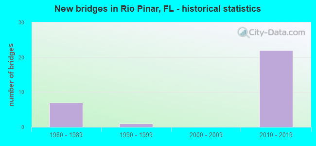
- New bridges - historical statistics
- 71980-1989
- 11990-1999
- 222010-2019

- Reconstructed bridges - Historical Statistics
- 22000-2009
- 22010-2019


- Bridge Condition - Deck
- 33.3%Very good
- 50.0%Good
- 16.7%Satisfactory

- Bridge Condition - Superstructure
- 16.7%Very good
- 83.3%Good

- Bridge Condition - Substructure
- 25.0%Excellent
- 33.3%Very good
- 41.7%Good

- Bridge Condition - Channel
- 33.3%Good
- 66.7%Satisfactory
Find on map >> Show street view
Structure Number: 750337, Location: Chickasaw Trail - SR-408 (Lat: 28.544678, Lng: -81.277483), Route carried "on" structure: County highway , Year Built: 1988, Year Reconstructed: 2011, Status: Open, Structure Length: 7.83m (25.69ft), Average Daily Traffic: 10,400 (year 2020), Truck Traffic: 6%, Average Future Daily Traffic: 18,044 (year 2042), Design Load: HL 93, Features Intersected: SR-408, Facility Carried by Structure: Chickasaw Trail
Minimum Vertical Clearance: 30+ m (98+ ft), Kilometerpoint: 9.650, Lanes on structure: 6, Lanes under structure: 10, Owner: State Toll Authority, Approaching Roadway Width: 14.6m (47.9ft), Skew: 23 degrees, Material/Design: Steel continuous, Design/Construction: Stringer/Multi-beam, Number Of Spans In Main Unit: 2, Length of Maximum Span: 44.8m (147.0ft), Curb or Sidewalk Widths: Left: 2.0m (6.6ft), Right: 2.0m (6.6ft), Curb-To-Curb Width: 25.5m (83.7ft), Out-to-Out Width: 32.5m (106.6ft)
Condition: Deck: Good, Superstructure: Good, Substructure: Very good, Operating Rating: 57.5 metric tons, Method Used To Determine Operating Rating: Load and Resistance Factor (LRFR), Inventory Rating: 44.4 metric tons, Method Used To Determine Inventory Rating: Load and Resistance Factor (LRFR), Structural Evaluation: Better than present minimum criteria, Deck Geometry: Somewhat better than minimum adequacy, Underclear: Meets minimum limits, Approach Roadway Alignment: Equal to present desirable criteria, Designated Inspection Frequency: Every 24 months, Inspection Date: June 2021, Deck Structure Type: Concrete Cast-file-Place
Find on map >> Show street view
Structure Number: 750382, Location: SR-417- Lake Underhill Rd (Lat: 28.539253, Lng: -81.251514), Route carried "on" structure: State highway 417, Year Built: 1989, Year Reconstructed: 2017, Status: Open, Structure Length: 3.60m (11.81ft), Average Daily Traffic: 53,750 (year 2020), Truck Traffic: 7%, Average Future Daily Traffic: 93,256 (year 2042), Design Load: HL 93, Features Intersected: Lake Underhill Rd
Minimum Vertical Clearance: 30+ m (98+ ft), Kilometerpoint: 9.186, Lanes on structure: 4, Lanes under structure: 3, Base Highway Network: Yes, Toll: On toll road, Owner: State Toll Authority, Approaching Roadway Width: 19.8m (65.0ft), Skew: 1 degrees, Material/Design: Prestressed concrete, Design/Construction: Stringer/Multi-beam, Number Of Spans In Main Unit: 1, Length of Maximum Span: 35.4m (116.1ft), Curb-To-Curb Width: 21.3m (69.9ft), Out-to-Out Width: 22.3m (73.2ft)
Condition: Deck: Good, Superstructure: Good, Substructure: Good, Operating Rating: 45.1 metric tons, Method Used To Determine Operating Rating: Load and Resistance Factor (LRFR), Inventory Rating: 33.0 metric tons, Method Used To Determine Inventory Rating: Load and Resistance Factor (LRFR), Structural Evaluation: Better than present minimum criteria, Deck Geometry: Better than present minimum criteria, Underclear: Meets minimum limits, Approach Roadway Alignment: Equal to present desirable criteria, Designated Inspection Frequency: Every 24 months, Inspection Date: September 2021, Deck Structure Type: Concrete Cast-file-Place
Find on map >> Show street view
Structure Number: 750383, Location: SR-417-Lake Underhill Rd (Lat: 28.539281, Lng: -81.251231), Route carried "on" structure: State highway 417, Year Built: 1989, Year Reconstructed: 2017, Status: Open, Structure Length: 3.60m (11.81ft), Average Daily Traffic: 53,750 (year 2020), Truck Traffic: 7%, Average Future Daily Traffic: 93,256 (year 2042), Design Load: HL 93, Features Intersected: Lake Underhill Rd
Minimum Vertical Clearance: 30+ m (98+ ft), Kilometerpoint: 9.186, Lanes on structure: 4, Lanes under structure: 3, Base Highway Network: Yes, Toll: On toll road, Owner: State Toll Authority, Approaching Roadway Width: 19.8m (65.0ft), Skew: 1 degrees, Material/Design: Prestressed concrete, Design/Construction: Stringer/Multi-beam, Number Of Spans In Main Unit: 1, Length of Maximum Span: 35.4m (116.1ft), Curb-To-Curb Width: 21.3m (69.9ft), Out-to-Out Width: 22.3m (73.2ft)
Condition: Deck: Satisfactory, Superstructure: Good, Substructure: Very good, Operating Rating: 45.7 metric tons, Method Used To Determine Operating Rating: Load and Resistance Factor (LRFR), Inventory Rating: 33.7 metric tons, Method Used To Determine Inventory Rating: Load and Resistance Factor (LRFR), Structural Evaluation: Better than present minimum criteria, Deck Geometry: Better than present minimum criteria, Underclear: Meets minimum limits, Approach Roadway Alignment: Equal to present desirable criteria, Designated Inspection Frequency: Every 24 months, Inspection Date: September 2021, Deck Structure Type: Concrete Cast-file-Place
Find on map >> Show street view
Structure Number: 750823, Location: SR-417 SB to SR-408 WB (Lat: 28.549067, Lng: -81.261517), Route carried "on" structure: Ramp State highway 417, Year Built: 2012, Status: Open, Structure Length: 26.33m (86.38ft), Average Daily Traffic: 28,000 (year 2020), Truck Traffic: 6%, Average Future Daily Traffic: 48,580 (year 2042), Design Load: HL 93, Features Intersected: Drainage Pond 8, Facility Carried by Structure: Ramp G
Minimum Vertical Clearance: 30+ m (98+ ft), Kilometerpoint: 0.172, Lanes on structure: 2, Toll: On toll road, Owner: State Toll Authority, Approaching Roadway Width: 13.3m (43.6ft), Material/Design: Prestressed concrete, Design/Construction: Stringer/Multi-beam, Number Of Spans In Main Unit: 9, Length of Maximum Span: 29.3m (96.1ft), Curb-To-Curb Width: 13.3m (43.6ft), Out-to-Out Width: 14.1m (46.3ft)
Condition: Deck: Very good, Superstructure: Very good, Substructure: Good, Channel: Good, Operating Rating: 41.2 metric tons, Method Used To Determine Operating Rating: Load and Resistance Factor (LRFR), Inventory Rating: 37.6 metric tons, Method Used To Determine Inventory Rating: Load and Resistance Factor (LRFR), Structural Evaluation: Better than present minimum criteria, Deck Geometry: Superior to present desirable criteria, Waterway Adequacy: Better than present minimum criteria, Approach Roadway Alignment: Equal to present desirable criteria, Designated Inspection Frequency: Every 24 months, Underwater Inspection Frequency: Every 24 months, Inspection Date: January 2022, Underwater Inspection Date: January 2022, Deck Structure Type: Concrete Cast-file-Place
Find on map >> Show street view
Structure Number: 750824, Location: Ramp G over Val Col Ln (Lat: 28.553750, Lng: -81.265256), Route carried "on" structure: Ramp State highway 417, Year Built: 2012, Status: Open, Structure Length: 5.27m (17.29ft), Average Daily Traffic: 28,000 (year 2020), Truck Traffic: 6%, Average Future Daily Traffic: 48,580 (year 2042), Design Load: HL 93, Features Intersected: Valancia College Lane
Minimum Vertical Clearance: 30+ m (98+ ft), Kilometerpoint: 0.460, Lanes on structure: 2, Lanes under structure: 4, Toll: On toll road, Owner: State Toll Authority, Approaching Roadway Width: 12.2m (40.0ft), Skew: 4 degrees, Material/Design: Prestressed concrete, Design/Construction: Stringer/Multi-beam, Number Of Spans In Main Unit: 1, Length of Maximum Span: 52.1m (170.9ft), Curb-To-Curb Width: 12.2m (40.0ft), Out-to-Out Width: 13.1m (43.0ft)
Condition: Deck: Very good, Superstructure: Good, Substructure: Very good, Operating Rating: 44.7 metric tons, Method Used To Determine Operating Rating: Load and Resistance Factor (LRFR), Inventory Rating: 40.8 metric tons, Method Used To Determine Inventory Rating: Load and Resistance Factor (LRFR), Structural Evaluation: Better than present minimum criteria, Deck Geometry: Superior to present desirable criteria, Underclear: Superior to present desirable criteria, Approach Roadway Alignment: Equal to present desirable criteria, Designated Inspection Frequency: Every 24 months, Inspection Date: May 2020, Deck Structure Type: Concrete Cast-file-Place
Find on map >> Show street view
Structure Number: 750825, Location: SR-408 and SR-417 (Lat: 28.548744, Lng: -81.260592), Route carried "on" structure: Ramp State highway 408, Year Built: 2012, Status: Open, Structure Length: 47.67m (156.40ft), Average Daily Traffic: 25,000 (year 2020), Truck Traffic: 6%, Average Future Daily Traffic: 43,375 (year 2042), Design Load: HL 93, Features Intersected: SR-408 and SR-417, Facility Carried by Structure: Ramp D Flyover
Minimum Vertical Clearance: 30.45m (99.90ft), Kilometerpoint: 0.579, Lanes on structure: 2, Lanes under structure: 16, Toll: On toll road, Owner: State Toll Authority, Approaching Roadway Width: 13.1m (43.0ft), Skew: 9 degrees, Material/Design: Steel continuous, Design/Construction: Box Beam or Girders - Single/Spread, Number Of Spans In Main Unit: 7, Length of Maximum Span: 85.6m (280.8ft), Curb-To-Curb Width: 13.1m (43.0ft), Out-to-Out Width: 14.2m (46.6ft)
Condition: Deck: Good, Superstructure: Good, Substructure: Good, Operating Rating: 46.4 metric tons, Method Used To Determine Operating Rating: Load and Resistance Factor (LRFR), Inventory Rating: 35.9 metric tons, Method Used To Determine Inventory Rating: Load and Resistance Factor (LRFR), Structural Evaluation: Better than present minimum criteria, Deck Geometry: Superior to present desirable criteria, Underclear: High priority of corrective action, Approach Roadway Alignment: Better than present minimum criteria, Designated Inspection Frequency: Every 24 months, Critical Feature Inspection Frequency: Every 24 months, Inspection Date: January 2022, Critical Feature Inspection Date: January 2022, Deck Structure Type: Concrete Cast-file-Place
Find on map >> Show street view
Structure Number: 750834, Location: SR-417 Ramp E over SR-408 (Lat: 28.547306, Lng: -81.258194), Route carried "on" structure: Ramp State highway 417, Year Built: 2017, Status: Open, Structure Length: 8.55m (28.05ft), Average Daily Traffic: 4,500 (year 2017), Average Future Daily Traffic: 7,808 (year 2039), Design Load: HL 93, Features Intersected: SR-408
Minimum Vertical Clearance: 30+ m (98+ ft), Kilometerpoint: 0.000, Lanes on structure: 1, Lanes under structure: 7, Base Highway Network: Yes, Toll: On toll road, Owner: State Toll Authority, Approaching Roadway Width: 8.3m (27.2ft), Skew: 4 degrees, Material/Design: Prestressed concrete, Design/Construction: Stringer/Multi-beam, Number Of Spans In Main Unit: 2, Length of Maximum Span: 42.9m (140.7ft), Curb-To-Curb Width: 8.3m (27.2ft), Out-to-Out Width: 9.2m (30.2ft)
Condition: Deck: Very good, Superstructure: Very good, Substructure: Very good, Operating Rating: 46.7 metric tons, Method Used To Determine Operating Rating: Load and Resistance Factor (LRFR), Inventory Rating: 33.3 metric tons, Method Used To Determine Inventory Rating: Load and Resistance Factor (LRFR), Structural Evaluation: Equal to present desirable criteria, Deck Geometry: Superior to present desirable criteria, Underclear: Better than present minimum criteria, Approach Roadway Alignment: Equal to present desirable criteria, Designated Inspection Frequency: Every 24 months, Inspection Date: March 2020, Deck Structure Type: Concrete Cast-file-Place
Find on map >> Show street view
Structure Number: 750836, Location: SR-417 and SR-408 (Lat: 28.546714, Lng: -81.256678), Route carried "on" structure: Ramp State highway 417, Year Built: 2019, Status: Open, Structure Length: 35.22m (115.55ft), Average Daily Traffic: 11,500 (year 2020), Truck Traffic: 6%, Average Future Daily Traffic: 19,953 (year 2042), Design Load: HL 93, Features Intersected: SR-417, SR-408
Minimum Vertical Clearance: 30+ m (98+ ft), Kilometerpoint: 9.926, Lanes on structure: 2, Lanes under structure: 11, Toll: On toll road, Owner: State Toll Authority, Approaching Roadway Width: 12.9m (42.3ft), Skew: 9 degrees, Material/Design: Prestressed concrete continuous, Design/Construction: Box Beam or Girders - Single/Spread, Number Of Spans In Main Unit: 7, Length of Maximum Span: 58.9m (193.2ft), Curb-To-Curb Width: 12.9m (42.3ft), Out-to-Out Width: 13.9m (45.6ft)
Condition: Deck: Good, Superstructure: Good, Substructure: Excellent, Operating Rating: 34.7 metric tons, Method Used To Determine Operating Rating: Load and Resistance Factor (LRFR), Inventory Rating: 32.7 metric tons, Method Used To Determine Inventory Rating: Load and Resistance Factor (LRFR), Structural Evaluation: Better than present minimum criteria, Deck Geometry: Superior to present desirable criteria, Underclear: Meets minimum limits, Approach Roadway Alignment: Better than present minimum criteria, Designated Inspection Frequency: Every 24 months, Inspection Date: January 2022, Deck Structure Type: Concrete Cast-file-Place, Wearing Surface/Protective System: Wearing Surface: Monolithic Concrete
Find on map >> Show street view
Structure Number: 750837, Location: SR-408 WB to SR-417 SB (Lat: 28.549500, Lng: -81.259736), Route carried "on" structure: Ramp State highway 408, Year Built: 2019, Status: Open, Structure Length: 41.01m (134.55ft), Average Daily Traffic: 13,500 (year 2020), Truck Traffic: 5%, Average Future Daily Traffic: 23,423 (year 2042), Design Load: HL 93, Features Intersected: SR-417 SR-408 & Rmps C&E
Minimum Vertical Clearance: 30+ m (98+ ft), Kilometerpoint: 1.841, Lanes on structure: 2, Lanes under structure: 14, Toll: On toll road, Owner: State Toll Authority, Approaching Roadway Width: 10.1m (33.1ft), Skew: 9 degrees, Material/Design: Prestressed concrete continuous, Design/Construction: Box Beam or Girders - Single/Spread, Number Of Spans In Main Unit: 9, Length of Maximum Span: 48.4m (158.8ft), Curb-To-Curb Width: 10.1m (33.1ft), Out-to-Out Width: 11.1m (36.4ft)
Condition: Deck: Very good, Superstructure: Good, Substructure: Excellent, Operating Rating: 49.4 metric tons, Method Used To Determine Operating Rating: Load and Resistance Factor (LRFR), Inventory Rating: 33.9 metric tons, Method Used To Determine Inventory Rating: Load and Resistance Factor (LRFR), Structural Evaluation: Better than present minimum criteria, Deck Geometry: Equal to present minimum criteria, Underclear: Equal to present minimum criteria, Approach Roadway Alignment: Better than present minimum criteria, Designated Inspection Frequency: Every 24 months, Inspection Date: January 2022, Deck Structure Type: Concrete Cast-file-Place, Wearing Surface/Protective System: Wearing Surface: Monolithic Concrete
Find on map >> Show street view
Structure Number: 750838, Location: SR-408 EB to SR-417 SB (Lat: 28.546667, Lng: -81.260961), Route carried "on" structure: Ramp State highway 408, Year Built: 2019, Status: Open, Structure Length: 32.24m (105.77ft), Average Daily Traffic: 5,300 (year 2020), Truck Traffic: 6%, Average Future Daily Traffic: 9,196 (year 2042), Design Load: HL 93, Features Intersected: Ramp E, Facility Carried by Structure: Ramp D1
Minimum Vertical Clearance: 30+ m (98+ ft), Kilometerpoint: 1.516, Lanes on structure: 2, Lanes under structure: 2, Toll: On toll road, Owner: State Toll Authority, Approaching Roadway Width: 12.2m (40.0ft), Skew: 39 degrees, Material/Design: Prestressed concrete continuous, Design/Construction: Box Beam or Girders - Single/Spread, Number Of Spans In Main Unit: 8, Length of Maximum Span: 54.6m (179.1ft), Curb-To-Curb Width: 12.2m (40.0ft), Out-to-Out Width: 13.3m (43.6ft)
Condition: Deck: Good, Superstructure: Good, Substructure: Excellent, Operating Rating: 34.9 metric tons, Method Used To Determine Operating Rating: Load and Resistance Factor (LRFR), Inventory Rating: 34.3 metric tons, Method Used To Determine Inventory Rating: Load and Resistance Factor (LRFR), Structural Evaluation: Better than present minimum criteria, Deck Geometry: Superior to present desirable criteria, Underclear: Superior to present desirable criteria, Approach Roadway Alignment: Better than present minimum criteria, Designated Inspection Frequency: Every 24 months, Inspection Date: January 2022, Deck Structure Type: Concrete Cast-file-Place, Wearing Surface/Protective System: Wearing Surface: Monolithic Concrete
Find on map >> Show street view
Structure Number: 754066, Location: 1.2 Miles East Of SR-551 (Lat: 28.509994, Lng: -81.271381), Route carried "on" structure: County highway 552, Year Built: 1980, Year Reconstructed: 2006, Status: Open, Structure Length: 4.89m (16.04ft), Average Daily Traffic: 31,000 (year 2021), Truck Traffic: 4%, Average Future Daily Traffic: 53,785 (year 2042), Design Load: HS 20, Features Intersected: Azalea Pk Outfall Canal, Facility Carried by Structure: Curry Ford Road
Minimum Vertical Clearance: 30+ m (98+ ft), Kilometerpoint: 6.212, Lanes on structure: 4, Owner: County Highway Agency, Approaching Roadway Width: 28.6m (93.8ft), Skew: 20 degrees, Material/Design: Prestressed concrete, Design/Construction: Stringer/Multi-beam, Number Of Spans In Main Unit: 3, Length of Maximum Span: 16.3m (53.5ft), Curb or Sidewalk Widths: Left: 2.1m (6.9ft), Right: 2.1m (6.9ft), Curb-To-Curb Width: 28.6m (93.8ft), Out-to-Out Width: 34.1m (111.9ft)
Condition: Deck: Good, Superstructure: Good, Substructure: Good, Channel: Satisfactory, Operating Rating: 30.7 metric tons, Method Used To Determine Operating Rating: Load Factor (LF), Inventory Rating: 26.1 metric tons, Method Used To Determine Inventory Rating: Load Factor (LF), Structural Evaluation: Equal to present minimum criteria, Deck Geometry: Superior to present desirable criteria, Waterway Adequacy: Somewhat better than minimum adequacy, Approach Roadway Alignment: Equal to present desirable criteria, Designated Inspection Frequency: Every 24 months, Inspection Date: October 2021, Deck Structure Type: Concrete Cast-file-Place
Find on map >> Show street view
Structure Number: 754108, Location: 0.3 Miles S of Curry Ford (Lat: 28.505067, Lng: -81.269056), Route carried "on" structure: City street , Year Built: 1997, Status: Open, Structure Length: 3.05m (10.01ft), Average Daily Traffic: 12,200 (year 2021), Truck Traffic: 6%, Average Future Daily Traffic: 21,167 (year 2042), Design Load: HS 20, Features Intersected: Azalea Park Canal, Facility Carried by Structure: Chickasaw Trail
Minimum Vertical Clearance: 30+ m (98+ ft), Kilometerpoint: 4.598, Lanes on structure: 2, Owner: County Highway Agency, Approaching Roadway Width: 12.3m (40.4ft), Skew: 4 degrees, Material/Design: Prestressed concrete, Design/Construction: Stringer/Multi-beam, Number Of Spans In Main Unit: 1, Length of Maximum Span: 30.5m (100.1ft), Curb or Sidewalk Widths: Left: 0.0m, Right: 1.6m (5.2ft), Curb-To-Curb Width: 12.3m (40.4ft), Out-to-Out Width: 15.0m (49.2ft)
Condition: Deck: Satisfactory, Superstructure: Good, Substructure: Good, Channel: Satisfactory, Operating Rating: 80.7 metric tons, Method Used To Determine Operating Rating: Load Factor (LF), Inventory Rating: 49.9 metric tons, Method Used To Determine Inventory Rating: Load Factor (LF), Structural Evaluation: Better than present minimum criteria, Deck Geometry: Somewhat better than minimum adequacy, Waterway Adequacy: Superior to present desirable criteria, Approach Roadway Alignment: Equal to present desirable criteria, Designated Inspection Frequency: Every 24 months, Inspection Date: October 2021, Deck Structure Type: Concrete Cast-file-Place
Find on map >> Show street view
Structure Number: 750337, Location: Chickasaw Trail - SR-408 (Lat: 28.544678, Lng: -81.277483), Route carried "under" structure: State highway 408, Year Built: 1988, Structure Length: 0. m, Average Daily Traffic: 139,500 (year 2020), Truck Traffic: 4%, Features Intersected: SR-408, Facility Carried by Structure: Chickasaw Trail
Minimum Vertical Clearance: 5.03m (16.50ft), Kilometerpoint: 18.955, Lanes on structure: 6, Lanes under structure: 10, Toll: On toll road, Material/Design: Steel continuous, Design/Construction: Stringer/Multi-beam, Length of Maximum Span: 44.8m (147.0ft)
Find on map >> Show street view
Structure Number: 750382, Location: SR-417- Lake Underhill Rd (Lat: 28.539253, Lng: -81.251514), Route carried "under" structure: Alternate County highway , Year Built: 1989, Structure Length: 0. m, Average Daily Traffic: 24,500 (year 2020), Truck Traffic: 7%, Features Intersected: Lake Underhill Rd, Facility Carried by Structure: SR-417 SB
Minimum Vertical Clearance: 4.79m (15.72ft), Kilometerpoint: 3.346, Lanes on structure: 4, Lanes under structure: 3, Material/Design: Prestressed concrete, Design/Construction: Stringer/Multi-beam, Length of Maximum Span: 35.4m (116.1ft)
Find on map >> Show street view
Structure Number: 750383, Location: SR-417-Lake Underhill Rd (Lat: 28.539281, Lng: -81.251231), Route carried "under" structure: Alternate County highway , Year Built: 1989, Structure Length: 0. m, Average Daily Traffic: 24,500 (year 2020), Truck Traffic: 7%, Features Intersected: Lake Underhill Rd, Facility Carried by Structure: SR-417 NB
Minimum Vertical Clearance: 4.97m (16.31ft), Kilometerpoint: 3.373, Lanes on structure: 4, Lanes under structure: 3, Material/Design: Prestressed concrete, Design/Construction: Stringer/Multi-beam, Length of Maximum Span: 35.4m (116.1ft)
Find on map >> Show street view
Structure Number: 750824, Location: Ramp G over Val Col Ln (Lat: 28.553750, Lng: -81.265256), Route carried "under" structure: City street , Year Built: 2012, Structure Length: 0. m, Average Daily Traffic: 8,000 (year 2020), Truck Traffic: 7%, Features Intersected: Valancia College Lane, Facility Carried by Structure: SR-417 Ramp G
Minimum Vertical Clearance: 5.33m (17.49ft), Kilometerpoint: 1.225, Lanes on structure: 2, Lanes under structure: 4, Material/Design: Prestressed concrete, Design/Construction: Stringer/Multi-beam, Length of Maximum Span: 52.1m (170.9ft)
Find on map >> Show street view
Structure Number: 750825, Location: SR-408 and SR-417 (Lat: 28.548744, Lng: -81.260592), Route carried "under" structure: Ramp State highway 417, Year Built: 2012, Structure Length: 0. m, Average Daily Traffic: 13,000 (year 2020), Truck Traffic: 6%, Features Intersected: SR-408 and SR-417, Facility Carried by Structure: Ramp D Flyover
Minimum Vertical Clearance: 5.27m (17.29ft), Kilometerpoint: 0.000, Lanes on structure: 2, Lanes under structure: 2, Toll: On toll road, Material/Design: Steel continuous, Design/Construction: Box Beam or Girders - Single/Spread, Length of Maximum Span: 85.6m (280.8ft)
Find on map >> Show street view
Structure Number: 750825, Location: SR-408 and SR-417 (Lat: 28.548744, Lng: -81.260592), Route carried "under" structure: State highway 408, Year Built: 2012, Structure Length: 0. m, Average Daily Traffic: 72,000 (year 2020), Truck Traffic: 3%, Features Intersected: SR-408 and SR-417, Facility Carried by Structure: Ramp D Flyover
Minimum Vertical Clearance: 10.39m (34.09ft), Kilometerpoint: 1.376, Lanes on structure: 2, Lanes under structure: 6, Toll: On toll road, Material/Design: Steel continuous, Design/Construction: Box Beam or Girders - Single/Spread, Length of Maximum Span: 85.6m (280.8ft)
Find on map >> Show street view
Structure Number: 750825, Location: SR-408 and SR-417 (Lat: 28.548744, Lng: -81.260592), Route carried "under" structure: Ramp State highway 417, Year Built: 2012, Structure Length: 0. m, Average Daily Traffic: 14,000 (year 2020), Truck Traffic: 6%, Features Intersected: SR-408 and SR-417, Facility Carried by Structure: Ramp D Flyover
Minimum Vertical Clearance: 5.85m (19.19ft), Kilometerpoint: 0.000, Lanes on structure: 2, Lanes under structure: 1, Toll: On toll road, Material/Design: Steel continuous, Design/Construction: Box Beam or Girders - Single/Spread, Length of Maximum Span: 85.6m (280.8ft)
Find on map >> Show street view
Structure Number: 750825, Location: SR-408 and SR-417 (Lat: 28.548744, Lng: -81.260592), Route carried "under" structure: State highway 417, Year Built: 2012, Structure Length: 0. m, Average Daily Traffic: 84,500 (year 2020), Truck Traffic: 7%, Features Intersected: SR-408 and SR-417, Facility Carried by Structure: Ramp D Flyover
Minimum Vertical Clearance: 6.49m (21.29ft), Kilometerpoint: 10.686, Lanes on structure: 2, Lanes under structure: 6, Toll: On toll road, Material/Design: Steel continuous, Design/Construction: Box Beam or Girders - Single/Spread, Length of Maximum Span: 85.6m (280.8ft)
Find on map >> Show street view
Structure Number: 750825, Location: SR-408 and SR-417 (Lat: 28.548744, Lng: -81.260592), Route carried "under" structure: Ramp State highway 408, Year Built: 2012, Structure Length: 0. m, Average Daily Traffic: 15,000 (year 2020), Truck Traffic: 6%, Features Intersected: SR-408 and SR-417, Facility Carried by Structure: Ramp D Flyover
Minimum Vertical Clearance: 5.79m (19.00ft), Kilometerpoint: 0.156, Lanes on structure: 2, Lanes under structure: 1, Toll: On toll road, Material/Design: Steel continuous, Design/Construction: Box Beam or Girders - Single/Spread, Length of Maximum Span: 85.6m (280.8ft)
Find on map >> Show street view
Structure Number: 750834, Location: SR-417 Ramp E over SR-408 (Lat: 28.547306, Lng: -81.258194), Route carried "under" structure: Alternate State highway , Year Built: 2017, Structure Length: 0. m, Average Daily Traffic: 116,500 (year 2019), Truck Traffic: 5%, Features Intersected: SR-408, Facility Carried by Structure: SR-417 SB Ramp E
Minimum Vertical Clearance: 5.36m (17.59ft), Kilometerpoint: 1.772, Lanes on structure: 1, Lanes under structure: 7, Toll: On toll road, Material/Design: Prestressed concrete, Design/Construction: Stringer/Multi-beam, Length of Maximum Span: 42.9m (140.7ft)
Find on map >> Show street view
Structure Number: 750836, Location: SR-417 and SR-408 (Lat: 28.546714, Lng: -81.256678), Route carried "under" structure: State highway 408, Year Built: 2019, Structure Length: 0. m, Average Daily Traffic: 72,000 (year 2020), Truck Traffic: 3%, Features Intersected: SR-417, SR-408, Facility Carried by Structure: SR-417 NB Ramp C
Minimum Vertical Clearance: 11.84m (38.85ft), Kilometerpoint: 1.873, Lanes on structure: 2, Lanes under structure: 4, Toll: On toll road, Material/Design: Prestressed concrete continuous, Design/Construction: Box Beam or Girders - Single/Spread, Length of Maximum Span: 58.9m (193.2ft)
Find on map >> Show street view
Structure Number: 750836, Location: SR-417 and SR-408 (Lat: 28.546714, Lng: -81.256678), Route carried "under" structure: State highway 417, Year Built: 2019, Structure Length: 0. m, Average Daily Traffic: 84,500 (year 2020), Truck Traffic: 7%, Features Intersected: SR-417, SR-408
Minimum Vertical Clearance: 5.91m (19.39ft), Kilometerpoint: 10.429, Lanes on structure: 2, Lanes under structure: 7, Toll: On toll road, Material/Design: Prestressed concrete continuous, Design/Construction: Box Beam or Girders - Single/Spread, Length of Maximum Span: 58.9m (193.2ft)
Find on map >> Show street view
Structure Number: 750837, Location: SR-408 WB to SR-417 SB (Lat: 28.549500, Lng: -81.259736), Route carried "under" structure: Ramp State highway 41, Year Built: 2019, Structure Length: 0. m, Average Daily Traffic: 14,000 (year 2020), Truck Traffic: 6%, Features Intersected: SR-417 SR-408 & Rmps C&E, Facility Carried by Structure: SR-408 WB Ramp A
Minimum Vertical Clearance: 13.05m (42.81ft), Kilometerpoint: 0.274, Lanes on structure: 2, Lanes under structure: 1, Toll: On toll road, Material/Design: Prestressed concrete continuous, Design/Construction: Box Beam or Girders - Single/Spread, Length of Maximum Span: 48.4m (158.8ft)
Find on map >> Show street view
Structure Number: 750837, Location: SR-408 WB to SR-417 SB (Lat: 28.549500, Lng: -81.259736), Route carried "under" structure: State highway 408, Year Built: 2019, Structure Length: 0. m, Average Daily Traffic: 72,000 (year 2020), Truck Traffic: 3%, Features Intersected: SR-417 SR-408 & Rmps C&E
Minimum Vertical Clearance: 14.97m (49.11ft), Kilometerpoint: 1.606, Lanes on structure: 2, Lanes under structure: 4, Toll: On toll road, Material/Design: Prestressed concrete continuous, Design/Construction: Box Beam or Girders - Single/Spread, Length of Maximum Span: 48.4m (158.8ft)
Find on map >> Show street view
Structure Number: 750837, Location: SR-408 WB to SR-417 SB (Lat: 28.549500, Lng: -81.259736), Route carried "under" structure: State highway 408, Year Built: 2019, Structure Length: 0. m, Average Daily Traffic: 84,500 (year 2020), Truck Traffic: 7%, Features Intersected: SR-417 SR-408 & Rmps C&E
Minimum Vertical Clearance: 8.23m (27.00ft), Kilometerpoint: 10.607, Lanes on structure: 2, Lanes under structure: 7, Toll: On toll road, Material/Design: Prestressed concrete continuous, Design/Construction: Box Beam or Girders - Single/Spread, Length of Maximum Span: 48.4m (158.8ft)
Find on map >> Show street view
Structure Number: 750837, Location: SR-408 WB to SR-417 SB (Lat: 28.549500, Lng: -81.259736), Route carried "under" structure: Ramp State highway 417, Year Built: 2019, Structure Length: 0. m, Average Daily Traffic: 13,000 (year 2020), Truck Traffic: 6%, Features Intersected: SR-417 SR-408 & Rmps C&E, Facility Carried by Structure: SR-408 WB Ramp A
Minimum Vertical Clearance: 5.46m (17.91ft), Kilometerpoint: 0.431, Lanes on structure: 2, Lanes under structure: 2, Toll: On toll road, Material/Design: Prestressed concrete continuous, Design/Construction: Box Beam or Girders - Single/Spread, Length of Maximum Span: 48.4m (158.8ft)
Find on map >> Show street view
Structure Number: 750838, Location: SR-408 EB to SR-417 SB (Lat: 28.546667, Lng: -81.260961), Route carried "under" structure: Ramp State highway 417, Year Built: 2019, Structure Length: 0. m, Average Daily Traffic: 14,000 (year 2020), Truck Traffic: 6%, Features Intersected: Ramp E, Facility Carried by Structure: Ramp D1
Minimum Vertical Clearance: 5.46m (17.91ft), Kilometerpoint: 0.097, Lanes on structure: 2, Lanes under structure: 1, Toll: On toll road, Material/Design: Prestressed concrete continuous, Design/Construction: Box Beam or Girders - Single/Spread, Length of Maximum Span: 54.6m (179.1ft)
Find on map >> Show street view
Structure Number: 750838, Location: SR-408 EB to SR-417 SB (Lat: 28.546667, Lng: -81.260961), Route carried "under" structure: Ramp State highway 417, Year Built: 2019, Structure Length: 0. m, Average Daily Traffic: 14,000 (year 2020), Truck Traffic: 6%, Features Intersected: Ramp E, Facility Carried by Structure: Ramp D1
Minimum Vertical Clearance: 11.31m (37.11ft), Kilometerpoint: 0.241, Lanes on structure: 2, Lanes under structure: 1, Toll: On toll road, Material/Design: Prestressed concrete continuous, Design/Construction: Box Beam or Girders - Single/Spread, Length of Maximum Span: 54.6m (179.1ft)