Bridge Statistics for Ringgold, Georgia (GA)
Condition, Traffic, Stress, Structural Evaluation, Project Costs
- National Bridge Inventory (NBI) Statistics
- 36Number of bridges
- 541ft / 165mTotal length
- $154,782,000Total costs
- 708,870Total average daily traffic
- 22,190Total average daily truck traffic
- National Bridge Inventory (NBI) Registered Bridges for Ringgold
- No street view available for this location
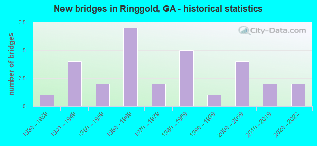
- New bridges - historical statistics
- 11930-1939
- 41940-1949
- 21950-1959
- 71960-1969
- 21970-1979
- 51980-1989
- 11990-1999
- 42000-2009
- 22010-2019
- 22020-2022

- Reconstructed bridges - Historical Statistics
- 41980-1989
- 21990-1999


- Bridge Condition - Deck
- 91.3%Good
- 4.3%Satisfactory
- 4.3%Poor

- Bridge Condition - Superstructure
- 26.1%Very good
- 56.5%Good
- 17.4%Satisfactory

- Bridge Condition - Substructure
- 4.3%Very good
- 65.2%Good
- 26.1%Satisfactory
- 4.3%Fair

- Bridge Condition - Channel
- 64.0%Very good
- 20.0%Good
- 12.0%Satisfactory
- 4.0%Fair

- Bridge Condition - Culverts
- 71.4%Good
- 28.6%Satisfactory
Find on map >> Show street view
Structure Number: 470007, Location: 4.5 MI SE FORT OGLETHORPE (Lat: 34.930950, Lng: -85.179069), Route carried "on" structure: State highway 2, Year Built: 1969, Status: Open, Structure Length: 4.57m (14.99ft), Average Daily Traffic: 17,470 (year 2012), Truck Traffic: 7%, Average Future Daily Traffic: 26,205 (year 2032), Design Load: HS 20+Mod, Features Intersected: PEAVINE CREEK
Minimum Vertical Clearance: 30+ m (98+ ft), Kilometerpoint: 8.047, Lanes on structure: 2, Base Highway Network: Yes, Owner: State Highway Agency, Approaching Roadway Width: 11.3m (37.1ft), Skew: 10 degrees, Material/Design: Steel, Design/Construction: Stringer/Multi-beam, Number Of Spans In Main Unit: 3, Length of Maximum Span: 15.2m (49.9ft), Curb-To-Curb Width: 12.2m (40.0ft), Out-to-Out Width: 12.9m (42.3ft)
Condition: Deck: Good, Superstructure: Good, Substructure: Good, Channel: Very good, Operating Rating: 40.8 metric tons, Method Used To Determine Operating Rating: Load Factor (LF), Inventory Rating: 24.4 metric tons, Method Used To Determine Inventory Rating: Load Factor (LF), Structural Evaluation: Equal to present minimum criteria, Deck Geometry: Better than present minimum criteria, Waterway Adequacy: Superior to present desirable criteria, Approach Roadway Alignment: Equal to present desirable criteria, Designated Inspection Frequency: Every 24 months, Other Special Inspection Frequency: Every 24 months, Inspection Date: November 2021, Other Special Inspection Date: November 2020, Bridge Improvement Cost: $586,000, Roadway Improvement Cost: $59,000, Total Project Cost: $879,000, Deck Structure Type: Concrete Cast-file-Place
Find on map >> Show street view
Structure Number: 470008, Location: 4.5 MI SE FORT OGLETHORPE (Lat: 34.931128, Lng: -85.178978), Route carried "on" structure: State highway 2, Year Built: 1969, Status: Open, Structure Length: 4.57m (14.99ft), Average Daily Traffic: 17,470 (year 2012), Truck Traffic: 7%, Average Future Daily Traffic: 26,205 (year 2032), Design Load: HS 20+Mod, Features Intersected: PEAVINE CREEK
Minimum Vertical Clearance: 30+ m (98+ ft), Kilometerpoint: 8.047, Lanes on structure: 2, Base Highway Network: Yes, Owner: State Highway Agency, Approaching Roadway Width: 11.3m (37.1ft), Skew: 10 degrees, Material/Design: Steel, Design/Construction: Stringer/Multi-beam, Number Of Spans In Main Unit: 3, Length of Maximum Span: 15.2m (49.9ft), Curb-To-Curb Width: 12.2m (40.0ft), Out-to-Out Width: 12.9m (42.3ft)
Condition: Deck: Satisfactory, Superstructure: Good, Substructure: Good, Channel: Very good, Operating Rating: 40.8 metric tons, Method Used To Determine Operating Rating: Load Factor (LF), Inventory Rating: 24.4 metric tons, Method Used To Determine Inventory Rating: Load Factor (LF), Structural Evaluation: Equal to present minimum criteria, Deck Geometry: Better than present minimum criteria, Waterway Adequacy: Superior to present desirable criteria, Approach Roadway Alignment: Equal to present desirable criteria, Designated Inspection Frequency: Every 24 months, Other Special Inspection Frequency: Every 24 months, Inspection Date: November 2021, Other Special Inspection Date: November 2020, Bridge Improvement Cost: $586,000, Roadway Improvement Cost: $59,000, Total Project Cost: $879,000, Deck Structure Type: Concrete Cast-file-Place
Find on map >> Show street view
Structure Number: 470009, Location: IN WEST RINGGOLD (Lat: 34.919089, Lng: -85.126242), Route carried "on" structure: US 41, Year Built: 1955, Year Reconstructed: 2003, Status: Open, Structure Length: 10.67m (35.01ft), Average Daily Traffic: 13,350 (year 2011), Truck Traffic: 1%, Average Future Daily Traffic: 20,025 (year 2031), Design Load: HS 20, Features Intersected: SOUTH CHICKAMAUGA CREEK
Minimum Vertical Clearance: 30+ m (98+ ft), Kilometerpoint: 12.875, Lanes on structure: 2, Owner: State Highway Agency, Approaching Roadway Width: 8.5m (27.9ft), Skew: 3 degrees, Material/Design: Steel, Design/Construction: Stringer/Multi-beam, Number Of Spans In Main Unit: 8, Length of Maximum Span: 16.8m (55.1ft), Curb-To-Curb Width: 9.8m (32.2ft), Out-to-Out Width: 10.7m (35.1ft)
Condition: Deck: Good, Superstructure: Good, Substructure: Fair, Channel: Good, Operating Rating: 39.9 metric tons, Method Used To Determine Operating Rating: Load Factor (LF), Inventory Rating: 23.5 metric tons, Method Used To Determine Inventory Rating: Load Factor (LF), Structural Evaluation: Somewhat better than minimum adequacy, Deck Geometry: Meets minimum limits, Waterway Adequacy: Equal to present desirable criteria, Approach Roadway Alignment: Equal to present desirable criteria, Length Of Structure Improvement: 17.10m (56.10ft), Designated Inspection Frequency: Every 24 months, Inspection Date: January 2022, Bridge Improvement Cost: $1,368,000, Roadway Improvement Cost: $137,000, Total Project Cost: $2,051,000, Deck Structure Type: Concrete Cast-file-Place
Find on map >> Show street view
Structure Number: 47001, Location: 1.8 MI E OF RINGGOLD (Lat: 34.908069, Lng: -85.080508), Route carried "on" structure: US 41, Year Built: 1942, Status: Open, Structure Length: 1.16m (3.81ft), Average Daily Traffic: 7,350 (year 2011), Truck Traffic: 1%, Average Future Daily Traffic: 11,025 (year 2031), Design Load: H 15, Features Intersected: CHEROKEE BRANCH
Minimum Vertical Clearance: 30+ m (98+ ft), Kilometerpoint: 19.312, Lanes on structure: 2, Base Highway Network: Yes, Owner: State Highway Agency, Approaching Roadway Width: 7.9m (25.9ft), Skew: 4 degrees, Material/Design: Concrete, Design/Construction: Culvert, Number Of Spans In Main Unit: 3, Length of Maximum Span: 3.7m (12.1ft)
Condition: Channel: Very good, Culverts: Satisfactory, Operating Rating: 41.7 metric tons, Method Used To Determine Operating Rating: Field evaluation and documented engineering judgment, Inventory Rating: 24.4 metric tons, Method Used To Determine Inventory Rating: Field evaluation and documented engineering judgment, Structural Evaluation: Equal to present minimum criteria, Waterway Adequacy: Superior to present desirable criteria, Approach Roadway Alignment: Equal to present desirable criteria, Designated Inspection Frequency: Every 24 months, Inspection Date: January 2022, Bridge Improvement Cost: $148,000, Roadway Improvement Cost: $15,000, Total Project Cost: $223,000
Find on map >> Show street view
Structure Number: 470017, Location: 5.5 MI S OF RINGGOLD (Lat: 34.843614, Lng: -85.141011), Route carried "on" structure: State highway 151, Year Built: 1986, Status: Open, Structure Length: 7.32m (24.02ft), Average Daily Traffic: 6,000 (year 2011), Truck Traffic: 1%, Average Future Daily Traffic: 9,000 (year 2031), Design Load: HS 20+Mod, Features Intersected: LITTLE CHICKAMAUGA CREEK
Minimum Vertical Clearance: 30+ m (98+ ft), Kilometerpoint: 8.047, Lanes on structure: 2, Base Highway Network: Yes, Owner: State Highway Agency, Approaching Roadway Width: 7.3m (24.0ft), Material/Design: Concrete, Design/Construction: Tee Beam, Number Of Spans In Main Unit: 6, Length of Maximum Span: 12.2m (40.0ft), Curb-To-Curb Width: 13.4m (44.0ft), Out-to-Out Width: 14.4m (47.2ft)
Condition: Deck: Good, Superstructure: Good, Substructure: Good, Channel: Very good, Operating Rating: 58.9 metric tons, Method Used To Determine Operating Rating: Load Factor (LF), Inventory Rating: 35.3 metric tons, Method Used To Determine Inventory Rating: Load Factor (LF), Structural Evaluation: Better than present minimum criteria, Deck Geometry: Equal to present minimum criteria, Waterway Adequacy: Superior to present desirable criteria, Approach Roadway Alignment: Equal to present desirable criteria, Designated Inspection Frequency: Every 24 months, Inspection Date: January 2022, Bridge Improvement Cost: $938,000, Roadway Improvement Cost: $94,000, Total Project Cost: $1,407,000, Deck Structure Type: Concrete Cast-file-Place
Find on map >> Show street view
Structure Number: 470018, Location: 4.2 MI S OF RINGGOLD (Lat: 34.859628, Lng: -85.144189), Route carried "on" structure: State highway 151, Year Built: 1948, Status: Open, Structure Length: 0.98m (3.22ft), Average Daily Traffic: 6,000 (year 2011), Truck Traffic: 1%, Average Future Daily Traffic: 9,000 (year 2031), Design Load: H 15, Features Intersected: LITTLE CHICKAMAUGA CR TR
Minimum Vertical Clearance: 30+ m (98+ ft), Kilometerpoint: 11.265, Lanes on structure: 2, Base Highway Network: Yes, Owner: State Highway Agency, Approaching Roadway Width: 7.3m (24.0ft), Material/Design: Concrete, Design/Construction: Culvert, Number Of Spans In Main Unit: 3, Length of Maximum Span: 3.0m (9.8ft)
Condition: Channel: Very good, Culverts: Good, Operating Rating: 50.8 metric tons, Method Used To Determine Operating Rating: Load Factor (LF), Inventory Rating: 29.9 metric tons, Method Used To Determine Inventory Rating: Load Factor (LF), Structural Evaluation: Better than present minimum criteria, Waterway Adequacy: Superior to present desirable criteria, Approach Roadway Alignment: Equal to present desirable criteria, Designated Inspection Frequency: Every 24 months, Inspection Date: January 2022, Bridge Improvement Cost: $125,000, Roadway Improvement Cost: $13,000, Total Project Cost: $188,000
Find on map >> Show street view
Structure Number: 470019, Location: 3 MI SW OF RINGGOLD (Lat: 34.881886, Lng: -85.138278), Route carried "on" structure: State highway 151, Year Built: 1948, Status: Open, Structure Length: 0.64m (2.10ft), Average Daily Traffic: 10,850 (year 2011), Truck Traffic: 1%, Average Future Daily Traffic: 16,275 (year 2031), Design Load: H 15, Features Intersected: LITTLE CHICKAMAUGA CR TR
Minimum Vertical Clearance: 30+ m (98+ ft), Kilometerpoint: 12.875, Lanes on structure: 2, Owner: State Highway Agency, Approaching Roadway Width: 7.3m (24.0ft), Material/Design: Concrete, Design/Construction: Culvert, Number Of Spans In Main Unit: 2, Length of Maximum Span: 3.0m (9.8ft), Curb-To-Curb Width: 7.3m (24.0ft), Out-to-Out Width: 8.8m (28.9ft)
Condition: Channel: Very good, Culverts: Good, Operating Rating: 63.5 metric tons, Method Used To Determine Operating Rating: Load Factor (LF), Inventory Rating: 38.1 metric tons, Method Used To Determine Inventory Rating: Load Factor (LF), Structural Evaluation: Better than present minimum criteria, Deck Geometry: High priority of replacement, Waterway Adequacy: Superior to present desirable criteria, Approach Roadway Alignment: Equal to present desirable criteria, Length Of Structure Improvement: 7.16m (23.49ft), Designated Inspection Frequency: Every 24 months, Inspection Date: January 2022, Bridge Improvement Cost: $82,000, Roadway Improvement Cost: $8,000, Total Project Cost: $123,000
Find on map >> Show street view
Structure Number: 47002, Location: 2.5 MI SW OF RINGGOLD (Lat: 34.886353, Lng: -85.135819), Route carried "on" structure: State highway 151, Year Built: 1948, Status: Open, Structure Length: 1.22m (4.00ft), Average Daily Traffic: 10,850 (year 2011), Truck Traffic: 1%, Average Future Daily Traffic: 16,275 (year 2031), Design Load: H 15, Features Intersected: LITTLE CHICKAMAUGA CR TR
Minimum Vertical Clearance: 30+ m (98+ ft), Kilometerpoint: 14.484, Lanes on structure: 2, Owner: State Highway Agency, Approaching Roadway Width: 7.3m (24.0ft), Skew: 4 degrees, Material/Design: Concrete, Design/Construction: Culvert, Number Of Spans In Main Unit: 3, Length of Maximum Span: 4.0m (13.1ft)
Condition: Channel: Satisfactory, Culverts: Good, Operating Rating: 49.8 metric tons, Method Used To Determine Operating Rating: Load Factor (LF), Inventory Rating: 29.9 metric tons, Method Used To Determine Inventory Rating: Load Factor (LF), Structural Evaluation: Better than present minimum criteria, Waterway Adequacy: Superior to present desirable criteria, Approach Roadway Alignment: Equal to present desirable criteria, Designated Inspection Frequency: Every 24 months, Inspection Date: January 2022, Bridge Improvement Cost: $156,000, Roadway Improvement Cost: $16,000, Total Project Cost: $234,000
Find on map >> Show street view
Structure Number: 470027, Location: 2 MI SE OF RINGGOLD (Lat: 34.895714, Lng: -85.080742), Route carried "on" structure: Interstate 75, Year Built: 1964, Year Reconstructed: 1988, Status: Open, Structure Length: 4.97m (16.31ft), Average Daily Traffic: 80,370 (year 2011), Truck Traffic: 1%, Average Future Daily Traffic: 120,555 (year 2031), Design Load: HS 20+Mod, Features Intersected: CSX RAILROAD (340572N)
Minimum Vertical Clearance: 30+ m (98+ ft), Kilometerpoint: 555.224, Lanes on structure: 7, Base Highway Network: Yes, Owner: State Highway Agency, Approaching Roadway Width: 38.4m (126.0ft), Skew: 32 degrees, Material/Design: Steel, Design/Construction: Stringer/Multi-beam, Number Of Spans In Main Unit: 3, Length of Maximum Span: 17.1m (56.1ft), Curb-To-Curb Width: 44.3m (145.3ft), Out-to-Out Width: 46.1m (151.2ft)
Condition: Deck: Good, Superstructure: Good, Substructure: Satisfactory, Operating Rating: 59.8 metric tons, Method Used To Determine Operating Rating: Load Factor (LF), Inventory Rating: 36.2 metric tons, Method Used To Determine Inventory Rating: Load Factor (LF), Structural Evaluation: Equal to present minimum criteria, Deck Geometry: Superior to present desirable criteria, Underclear: Somewhat better than minimum adequacy, Approach Roadway Alignment: Equal to present desirable criteria, Designated Inspection Frequency: Every 24 months, Inspection Date: December 2021, Bridge Improvement Cost: $1,505,000, Roadway Improvement Cost: $151,000, Total Project Cost: $2,258,000, Deck Structure Type: Concrete Cast-file-Place, Wearing Surface/Protective System: Wearing Surface: Epoxy Overlay
Find on map >> Show street view
Structure Number: 470029, Location: 1.9 MI SW OF RINGGOLD (Lat: 34.896997, Lng: -85.082406), Route carried "on" structure: Interstate 75, Year Built: 1960, Year Reconstructed: 1988, Status: Open, Structure Length: 9.14m (29.99ft), Average Daily Traffic: 80,370 (year 2011), Truck Traffic: 1%, Average Future Daily Traffic: 120,555 (year 2031), Design Load: HS 20+Mod, Features Intersected: SOUTH CHICKAMAUGA CREEK
Minimum Vertical Clearance: 30+ m (98+ ft), Kilometerpoint: 555.224, Lanes on structure: 6, Base Highway Network: Yes, Owner: State Highway Agency, Approaching Roadway Width: 35.7m (117.1ft), Skew: 33 degrees, Material/Design: Steel, Design/Construction: Stringer/Multi-beam, Number Of Spans In Main Unit: 5, Length of Maximum Span: 18.3m (60.0ft), Curb-To-Curb Width: 40.6m (133.2ft), Out-to-Out Width: 42.4m (139.1ft)
Condition: Deck: Good, Superstructure: Good, Substructure: Satisfactory, Channel: Fair, Operating Rating: 34.4 metric tons, Method Used To Determine Operating Rating: Load Factor (LF), Inventory Rating: 20.8 metric tons, Method Used To Determine Inventory Rating: Load Factor (LF), Structural Evaluation: Somewhat better than minimum adequacy, Deck Geometry: Superior to present desirable criteria, Waterway Adequacy: Equal to present desirable criteria, Approach Roadway Alignment: Equal to present desirable criteria, Designated Inspection Frequency: Every 24 months, Inspection Date: December 2021, Bridge Improvement Cost: $2,451,000, Roadway Improvement Cost: $245,000, Total Project Cost: $3,676,000, Deck Structure Type: Concrete Cast-file-Place, Wearing Surface/Protective System: Wearing Surface: Epoxy Overlay
Find on map >> Show street view
Structure Number: 470031, Location: 0.5 MI S OF RINGGOLD (Lat: 34.908972, Lng: -85.114806), Route carried "on" structure: Interstate 75, Year Built: 1960, Year Reconstructed: 1988, Status: Open, Structure Length: 5.30m (17.39ft), Average Daily Traffic: 80,370 (year 2011), Truck Traffic: 1%, Average Future Daily Traffic: 120,555 (year 2031), Design Load: HS 20+Mod, Features Intersected: LITTLE CHICKAMAUGA CREEK
Minimum Vertical Clearance: 30+ m (98+ ft), Kilometerpoint: 558.443, Lanes on structure: 6, Base Highway Network: Yes, Owner: State Highway Agency, Approaching Roadway Width: 34.1m (111.9ft), Skew: 33 degrees, Material/Design: Steel, Design/Construction: Stringer/Multi-beam, Number Of Spans In Main Unit: 3, Length of Maximum Span: 17.7m (58.1ft), Curb-To-Curb Width: 40.6m (133.2ft), Out-to-Out Width: 42.4m (139.1ft)
Condition: Deck: Good, Superstructure: Good, Substructure: Good, Channel: Good, Operating Rating: 31.7 metric tons, Method Used To Determine Operating Rating: Load Factor (LF), Inventory Rating: 19.0 metric tons, Method Used To Determine Inventory Rating: Load Factor (LF), Structural Evaluation: Meets minimum limits, Deck Geometry: Superior to present desirable criteria, Waterway Adequacy: Superior to present desirable criteria, Approach Roadway Alignment: Equal to present desirable criteria, Designated Inspection Frequency: Every 24 months, Inspection Date: December 2021, Bridge Improvement Cost: $1,422,000, Roadway Improvement Cost: $142,000, Total Project Cost: $2,132,000, Deck Structure Type: Concrete Cast-file-Place, Wearing Surface/Protective System: Wearing Surface: Epoxy Overlay
Find on map >> Show street view
Structure Number: 470033, Location: 2.7 MI W OF RINGGOLD (Lat: 34.928231, Lng: -85.152419), Route carried "on" structure: Interstate 75, Year Built: 1961, Year Reconstructed: 1988, Status: Open, Structure Length: 7.80m (25.59ft), Average Daily Traffic: 87,100 (year 2011), Truck Traffic: 1%, Average Future Daily Traffic: 130,650 (year 2031), Design Load: HS 20+Mod, Features Intersected: SR 2
Minimum Vertical Clearance: 30+ m (98+ ft), Kilometerpoint: 563.271, Lanes on structure: 6, Lanes under structure: 7, Base Highway Network: Yes, Owner: State Highway Agency, Approaching Roadway Width: 32.9m (107.9ft), Skew: 33 degrees, Material/Design: Steel continuous, Design/Construction: Stringer/Multi-beam, Number Of Spans In Main Unit: 4, Length of Maximum Span: 21.9m (71.9ft), Curb-To-Curb Width: 40.6m (133.2ft), Out-to-Out Width: 42.6m (139.8ft)
Condition: Deck: Good, Superstructure: Good, Substructure: Satisfactory, Operating Rating: 29.9 metric tons, Method Used To Determine Operating Rating: Load Factor (LF), Inventory Rating: 18.1 metric tons, Method Used To Determine Inventory Rating: Load Factor (LF), Structural Evaluation: Meets minimum limits, Deck Geometry: Superior to present desirable criteria, Underclear: High priority of corrective action, Approach Roadway Alignment: Equal to present desirable criteria, Designated Inspection Frequency: Every 24 months, Inspection Date: December 2021, Bridge Improvement Cost: $2,091,000, Roadway Improvement Cost: $209,000, Total Project Cost: $3,137,000, Deck Structure Type: Concrete Cast-file-Place, Wearing Surface/Protective System: Wearing Surface: Epoxy Overlay
Find on map >> Show street view
Structure Number: 470047, Location: 2 MI WEST OF RINGGOLD (Lat: 34.918989, Lng: -85.147308), Route carried "on" structure: City street 1110, Year Built: 1961, Status: Open, Structure Length: 7.83m (25.69ft), Average Daily Traffic: 4,950 (year 2011), Truck Traffic: 1%, Average Future Daily Traffic: 7,425 (year 2031), Design Load: H 15, Features Intersected: I-75
Minimum Vertical Clearance: 30+ m (98+ ft), Kilometerpoint: 11.265, Lanes on structure: 2, Lanes under structure: 6, Base Highway Network: Yes, Owner: State Highway Agency, Approaching Roadway Width: 6.4m (21.0ft), Skew: 3 degrees, Material/Design: Steel, Design/Construction: Stringer/Multi-beam, Number Of Spans In Main Unit: 4, Length of Maximum Span: 27.1m (88.9ft), Curb or Sidewalk Widths: Left: 0.7m (2.3ft), Right: 0.7m (2.3ft), Curb-To-Curb Width: 7.9m (25.9ft), Out-to-Out Width: 9.8m (32.2ft)
Condition: Deck: Poor, Superstructure: Satisfactory, Substructure: Satisfactory, Operating Rating: 32.6 metric tons, Method Used To Determine Operating Rating: Allowable Stress (AS), Inventory Rating: 20.8 metric tons, Method Used To Determine Inventory Rating: Allowable Stress (AS), Structural Evaluation: Somewhat better than minimum adequacy, Deck Geometry: High priority of corrective action, Underclear: Meets minimum limits, Approach Roadway Alignment: Equal to present desirable criteria, Length Of Structure Improvement: 14.26m (46.78ft), Designated Inspection Frequency: Every 24 months, Inspection Date: December 2021, Bridge Improvement Cost: $1,004,000, Roadway Improvement Cost: $100,000, Total Project Cost: $1,506,000, Deck Structure Type: Concrete Cast-file-Place
Find on map >> Show street view
Structure Number: 470048, Location: IN SOUTH RINGGOLD (Lat: 34.912981, Lng: -85.118400), Route carried "on" structure: County highway 820, Year Built: 1951, Year Reconstructed: 1997, Status: Open, Structure Length: 4.18m (13.71ft), Average Daily Traffic: 5,980 (year 2011), Truck Traffic: 1%, Average Future Daily Traffic: 8,970 (year 2031), Design Load: H 15, Features Intersected: SOUTH CHICKAMAUGA CREEK, Facility Carried by Structure: LAFAYETTE STREET
Minimum Vertical Clearance: 30+ m (98+ ft), Kilometerpoint: 3.219, Lanes on structure: 2, Owner: City or Municipal Highway Agency, Approaching Roadway Width: 6.4m (21.0ft), Material/Design: Steel, Design/Construction: Stringer/Multi-beam, Number Of Spans In Main Unit: 2, Length of Maximum Span: 21.0m (68.9ft), Curb or Sidewalk Widths: Left: 0.0m, Right: 1.8m (5.9ft), Curb-To-Curb Width: 10.2m (33.5ft), Out-to-Out Width: 13.2m (43.3ft)
Condition: Deck: Good, Superstructure: Good, Substructure: Good, Channel: Good, Operating Rating: 32.6 metric tons, Method Used To Determine Operating Rating: Load Factor (LF), Inventory Rating: 17.2 metric tons, Method Used To Determine Inventory Rating: Load Factor (LF), Structural Evaluation: Meets minimum limits, Deck Geometry: Meets minimum limits, Waterway Adequacy: Superior to present desirable criteria, Approach Roadway Alignment: Equal to present desirable criteria, Designated Inspection Frequency: Every 24 months, Inspection Date: January 2022, Bridge Improvement Cost: $535,000, Roadway Improvement Cost: $54,000, Total Project Cost: $803,000, Deck Structure Type: Concrete Cast-file-Place, Wearing Surface/Protective System: Wearing Surface: Monolithic Concrete
Find on map >> Show street view
Structure Number: 470055, Location: 4 MI SOUTH OF RINGGOLD (Lat: 34.861350, Lng: -85.085569), Route carried "on" structure: County highway 2210, Year Built: 1976, Status: Open, Structure Length: 4.39m (14.40ft), Average Daily Traffic: 1,030 (year 2011), Truck Traffic: 1%, Average Future Daily Traffic: 1,545 (year 2031), Design Load: HS 20+Mod, Features Intersected: EAST CHICKAMAUGA CREEK, Facility Carried by Structure: BANDY ROAD
Minimum Vertical Clearance: 30+ m (98+ ft), Kilometerpoint: 4.828, Lanes on structure: 2, Owner: County Highway Agency, Approaching Roadway Width: 6.1m (20.0ft), Skew: 3 degrees, Material/Design: Concrete, Design/Construction: Tee Beam, Number Of Spans In Main Unit: 4, Length of Maximum Span: 11.0m (36.1ft), Curb-To-Curb Width: 8.7m (28.5ft), Out-to-Out Width: 9.7m (31.8ft)
Condition: Deck: Good, Superstructure: Good, Substructure: Good, Channel: Good, Operating Rating: 32.6 metric tons, Method Used To Determine Operating Rating: Load Factor (LF), Inventory Rating: 19.9 metric tons, Method Used To Determine Inventory Rating: Load Factor (LF), Structural Evaluation: Somewhat better than minimum adequacy, Deck Geometry: Somewhat better than minimum adequacy, Waterway Adequacy: Superior to present desirable criteria, Approach Roadway Alignment: Equal to present desirable criteria, Designated Inspection Frequency: Every 24 months, Inspection Date: January 2022, Bridge Improvement Cost: $563,000, Roadway Improvement Cost: $56,000, Total Project Cost: $844,000, Deck Structure Type: Concrete Cast-file-Place
Find on map >> Show street view
Structure Number: 470058, Location: 2 MI S OF RINGGOLD (Lat: 34.896931, Lng: -85.130894), Route carried "on" structure: State highway 151, Year Built: 1938, Status: Open, Structure Length: 0.70m (2.30ft), Average Daily Traffic: 10,850 (year 2011), Truck Traffic: 1%, Average Future Daily Traffic: 16,275 (year 2031), Design Load: H 15, Features Intersected: CHICKAMAUGA CREEK TRIB
Minimum Vertical Clearance: 30+ m (98+ ft), Kilometerpoint: 14.484, Lanes on structure: 2, Owner: State Highway Agency, Approaching Roadway Width: 7.3m (24.0ft), Skew: 2 degrees, Material/Design: Concrete, Design/Construction: Culvert, Number Of Spans In Main Unit: 3, Length of Maximum Span: 2.1m (6.9ft)
Condition: Channel: Satisfactory, Culverts: Good, Operating Rating: 41.7 metric tons, Method Used To Determine Operating Rating: Field evaluation and documented engineering judgment, Inventory Rating: 24.4 metric tons, Method Used To Determine Inventory Rating: Field evaluation and documented engineering judgment, Structural Evaluation: Equal to present minimum criteria, Waterway Adequacy: Superior to present desirable criteria, Approach Roadway Alignment: Equal to present desirable criteria, Designated Inspection Frequency: Every 24 months, Inspection Date: January 2022, Bridge Improvement Cost: $90,000, Roadway Improvement Cost: $9,000, Total Project Cost: $135,000
Find on map >> Show street view
Structure Number: 475001, Location: 4 MI WEST OF RINGGOLD (Lat: 34.929628, Lng: -85.178239), Route carried "on" structure: County highway 2, Year Built: 1982, Status: Open, Structure Length: 1.52m (4.99ft), Average Daily Traffic: 1,480 (year 2011), Truck Traffic: 1%, Average Future Daily Traffic: 2,220 (year 2031), Features Intersected: PEAVINE CREEK, Facility Carried by Structure: OLD MILL ROAD
Minimum Vertical Clearance: 30+ m (98+ ft), Kilometerpoint: 3.219, Lanes on structure: 2, Owner: County Highway Agency, Approaching Roadway Width: 6.7m (22.0ft), Skew: 2 degrees, Material/Design: Steel, Design/Construction: Stringer/Multi-beam, Number Of Spans In Main Unit: 2, Length of Maximum Span: 7.6m (24.9ft), Curb-To-Curb Width: 8.7m (28.5ft), Out-to-Out Width: 9.8m (32.2ft)
Condition: Deck: Good, Superstructure: Satisfactory, Substructure: Satisfactory, Channel: Satisfactory, Operating Rating: 66.2 metric tons, Method Used To Determine Operating Rating: Load Factor (LF), Inventory Rating: 39.9 metric tons, Method Used To Determine Inventory Rating: Load Factor (LF), Structural Evaluation: Equal to present minimum criteria, Deck Geometry: Somewhat better than minimum adequacy, Waterway Adequacy: Equal to present desirable criteria, Approach Roadway Alignment: Equal to present desirable criteria, Designated Inspection Frequency: Every 24 months, Inspection Date: December 2021, Bridge Improvement Cost: $195,000, Roadway Improvement Cost: $20,000, Total Project Cost: $293,000, Deck Structure Type: Concrete Cast-file-Place, Wearing Surface/Protective System: Wearing Surface: Bituminous
Find on map >> Show street view
Structure Number: 475011, Location: 1.8 MI SW OF RINGGOLD (Lat: 34.894197, Lng: -85.125128), Route carried "on" structure: County highway 666, Year Built: 1991, Status: Open, Structure Length: 8.53m (27.99ft), Average Daily Traffic: 1,190 (year 2011), Truck Traffic: 1%, Average Future Daily Traffic: 1,785 (year 2031), Design Load: HS 20+Mod, Features Intersected: LITTLE CHICKAMAUGA CREEK, Facility Carried by Structure: ROLLINS IND. BLVD.
Minimum Vertical Clearance: 30+ m (98+ ft), Kilometerpoint: 0.000, Lanes on structure: 2, Owner: County Highway Agency, Approaching Roadway Width: 7.3m (24.0ft), Material/Design: Prestressed concrete, Design/Construction: Stringer/Multi-beam, Number Of Spans In Main Unit: 7, Length of Maximum Span: 12.2m (40.0ft), Curb-To-Curb Width: 9.1m (29.9ft), Out-to-Out Width: 10.1m (33.1ft)
Condition: Deck: Good, Superstructure: Very good, Substructure: Good, Channel: Very good, Operating Rating: 58.9 metric tons, Method Used To Determine Operating Rating: Load Factor (LF), Inventory Rating: 35.3 metric tons, Method Used To Determine Inventory Rating: Load Factor (LF), Structural Evaluation: Better than present minimum criteria, Deck Geometry: Somewhat better than minimum adequacy, Waterway Adequacy: Superior to present desirable criteria, Approach Roadway Alignment: Equal to present desirable criteria, Designated Inspection Frequency: Every 24 months, Inspection Date: January 2022, Bridge Improvement Cost: $1,094,000, Roadway Improvement Cost: $109,000, Total Project Cost: $1,641,000, Deck Structure Type: Concrete Cast-file-Place
Find on map >> Show street view
Structure Number: 475013, Location: 2.3 MI SE OF RINGGOLD (Lat: 34.888689, Lng: -85.083403), Route carried "on" structure: County highway 193, Year Built: 1984, Status: Open, Structure Length: 7.32m (24.02ft), Average Daily Traffic: 140 (year 2011), Truck Traffic: 1%, Average Future Daily Traffic: 210 (year 2031), Design Load: HS 15, Features Intersected: SOUTH CHICKAMAUGA CREEK, Facility Carried by Structure: GREENWOOD ROAD
Minimum Vertical Clearance: 30+ m (98+ ft), Kilometerpoint: 1.609, Lanes on structure: 2, Owner: County Highway Agency, Approaching Roadway Width: 7.3m (24.0ft), Skew: 3 degrees, Material/Design: Concrete, Design/Construction: Tee Beam, Number Of Spans In Main Unit: 6, Length of Maximum Span: 12.2m (40.0ft), Curb-To-Curb Width: 7.3m (24.0ft), Out-to-Out Width: 8.3m (27.2ft)
Condition: Deck: Good, Superstructure: Good, Substructure: Satisfactory, Channel: Very good, Operating Rating: 43.5 metric tons, Method Used To Determine Operating Rating: Load Factor (LF), Inventory Rating: 26.3 metric tons, Method Used To Determine Inventory Rating: Load Factor (LF), Structural Evaluation: Equal to present minimum criteria, Deck Geometry: Somewhat better than minimum adequacy, Waterway Adequacy: Equal to present desirable criteria, Approach Roadway Alignment: Equal to present desirable criteria, Designated Inspection Frequency: Every 24 months, Inspection Date: January 2022, Bridge Improvement Cost: $938,000, Roadway Improvement Cost: $94,000, Total Project Cost: $1,407,000, Deck Structure Type: Concrete Cast-file-Place
Find on map >> Show street view
Structure Number: 475024, Location: 5 MI S OF RINGGOLD (Lat: 34.844039, Lng: -85.110069), Route carried "on" structure: County highway 257, Year Built: 1978, Status: Posted for load, Structure Length: 0.76m (2.49ft), Average Daily Traffic: 460 (year 2011), Truck Traffic: 1%, Average Future Daily Traffic: 690 (year 2031), Features Intersected: DRY CREEK TRIB, Facility Carried by Structure: HOUSTON VALLEY RD
Minimum Vertical Clearance: 30+ m (98+ ft), Kilometerpoint: 4.828, Lanes on structure: 2, Owner: County Highway Agency, Approaching Roadway Width: 6.1m (20.0ft), Skew: 1 degrees, Material/Design: Steel, Design/Construction: Stringer/Multi-beam, Number Of Spans In Main Unit: 1, Length of Maximum Span: 7.6m (24.9ft), Curb-To-Curb Width: 7.3m (24.0ft), Out-to-Out Width: 8.5m (27.9ft)
Condition: Deck: Good, Superstructure: Satisfactory, Substructure: Good, Channel: Very good, Operating Rating: 38.1 metric tons, Method Used To Determine Operating Rating: Load Factor (LF), Inventory Rating: 22.6 metric tons, Method Used To Determine Inventory Rating: Load Factor (LF), Structural Evaluation: Equal to present minimum criteria, Deck Geometry: Meets minimum limits, Waterway Adequacy: Superior to present desirable criteria, Approach Roadway Alignment: Equal to present desirable criteria, Bridge Posting: Required (Relationship of Operating Rating to Maximum Legal Load: 0.1 - 9.9% below), Length Of Structure Improvement: 7.19m (23.59ft), Designated Inspection Frequency: Every 24 months, Inspection Date: January 2022, Bridge Improvement Cost: $98,000, Roadway Improvement Cost: $10,000, Total Project Cost: $147,000, Deck Structure Type: Concrete Cast-file-Place, Wearing Surface/Protective System: Wearing Surface: Bituminous
Find on map >> Show street view
Structure Number: 475029, Location: 4.2 MI W OF RINGGOLD (Lat: 34.922158, Lng: -85.181639), Route carried "on" structure: City street 1110, Year Built: 1980, Status: Open, Structure Length: 5.79m (19.00ft), Average Daily Traffic: 4,450 (year 2011), Truck Traffic: 1%, Average Future Daily Traffic: 6,675 (year 2031), Design Load: HS 20+Mod, Features Intersected: PEAVINE CREEK, Facility Carried by Structure: BOYNTON DRIVE
Minimum Vertical Clearance: 30+ m (98+ ft), Kilometerpoint: 8.047, Lanes on structure: 2, Owner: County Highway Agency, Approaching Roadway Width: 7.3m (24.0ft), Skew: 3 degrees, Material/Design: Concrete, Design/Construction: Tee Beam, Number Of Spans In Main Unit: 5, Length of Maximum Span: 11.6m (38.1ft), Curb-To-Curb Width: 11.0m (36.1ft), Out-to-Out Width: 12.0m (39.4ft)
Condition: Deck: Good, Superstructure: Good, Substructure: Good, Channel: Very good, Operating Rating: 39.0 metric tons, Method Used To Determine Operating Rating: Load Factor (LF), Inventory Rating: 23.5 metric tons, Method Used To Determine Inventory Rating: Load Factor (LF), Structural Evaluation: Equal to present minimum criteria, Deck Geometry: Somewhat better than minimum adequacy, Waterway Adequacy: Superior to present desirable criteria, Approach Roadway Alignment: Equal to present desirable criteria, Designated Inspection Frequency: Every 24 months, Inspection Date: January 2022, Bridge Improvement Cost: $742,000, Roadway Improvement Cost: $74,000, Total Project Cost: $1,114,000, Deck Structure Type: Concrete Cast-file-Place
Find on map >> Show street view
Structure Number: 475031, Location: 2.3 MI SE OF RINGGOLD (Lat: 34.888008, Lng: -85.082619), Route carried "on" structure: County highway 193, Year Built: 1984, Status: Open, Structure Length: 1.65m (5.41ft), Average Daily Traffic: 140 (year 2011), Truck Traffic: 1%, Average Future Daily Traffic: 210 (year 2031), Design Load: HS 20+Mod, Features Intersected: S. CHICKAMAUGA CREEK O/F, Facility Carried by Structure: GREENWOOD ROAD
Minimum Vertical Clearance: 30+ m (98+ ft), Kilometerpoint: 0.000, Lanes on structure: 2, Owner: County Highway Agency, Approaching Roadway Width: 7.3m (24.0ft), Material/Design: Concrete, Design/Construction: Culvert, Number Of Spans In Main Unit: 5, Length of Maximum Span: 3.0m (9.8ft)
Condition: Channel: Very good, Culverts: Satisfactory, Operating Rating: 55.3 metric tons, Method Used To Determine Operating Rating: Field evaluation and documented engineering judgment, Inventory Rating: 32.6 metric tons, Method Used To Determine Inventory Rating: Field evaluation and documented engineering judgment, Structural Evaluation: Equal to present minimum criteria, Waterway Adequacy: Superior to present desirable criteria, Approach Roadway Alignment: Equal to present desirable criteria, Designated Inspection Frequency: Every 24 months, Inspection Date: January 2022, Bridge Improvement Cost: $211,000, Roadway Improvement Cost: $21,000, Total Project Cost: $316,000
Find on map >> Show street view
Structure Number: 475041, Location: 2.4 MI E OF RINGGOLD (Lat: 34.906008, Lng: -85.068439), Route carried "on" structure: State highway 2, Year Built: 2001, Status: Open, Structure Length: 9.05m (29.69ft), Average Daily Traffic: 5,050 (year 2011), Truck Traffic: 1%, Average Future Daily Traffic: 7,575 (year 2031), Design Load: HS 20+Mod, Features Intersected: TIGER CREEK
Minimum Vertical Clearance: 30+ m (98+ ft), Kilometerpoint: 19.312, Lanes on structure: 2, Base Highway Network: Yes, Owner: State Highway Agency, Approaching Roadway Width: 8.2m (26.9ft), Skew: 5 degrees, Material/Design: Prestressed concrete, Design/Construction: Stringer/Multi-beam, Number Of Spans In Main Unit: 3, Length of Maximum Span: 30.2m (99.1ft), Curb-To-Curb Width: 13.2m (43.3ft), Out-to-Out Width: 14.1m (46.3ft)
Condition: Deck: Good, Superstructure: Satisfactory, Substructure: Good, Channel: Good, Operating Rating: 79.8 metric tons, Method Used To Determine Operating Rating: Load Factor (LF), Inventory Rating: 29.0 metric tons, Method Used To Determine Inventory Rating: Load Factor (LF), Structural Evaluation: Equal to present minimum criteria, Deck Geometry: Somewhat better than minimum adequacy, Waterway Adequacy: Equal to present desirable criteria, Approach Roadway Alignment: Equal to present desirable criteria, Designated Inspection Frequency: Every 24 months, Inspection Date: January 2022, Bridge Improvement Cost: $1,160,000, Roadway Improvement Cost: $116,000, Total Project Cost: $1,741,000, Deck Structure Type: Concrete Cast-file-Place
Find on map >> Show street view
Structure Number: 475042, Location: 2.5 MI SE OF RINGGOLD (Lat: 34.892431, Lng: -85.074483), Route carried "on" structure: US 41, Year Built: 2002, Status: Open, Structure Length: 15.00m (49.21ft), Average Daily Traffic: 10,650 (year 2011), Truck Traffic: 1%, Average Future Daily Traffic: 15,975 (year 2031), Design Load: HS 20+Mod, Features Intersected: I-75
Minimum Vertical Clearance: 30+ m (98+ ft), Kilometerpoint: 3.219, Lanes on structure: 5, Lanes under structure: 6, Base Highway Network: Yes, Owner: State Highway Agency, Approaching Roadway Width: 18.6m (61.0ft), Skew: 23 degrees, Material/Design: Steel continuous, Design/Construction: Stringer/Multi-beam, Number Of Spans In Main Unit: 4, Length of Maximum Span: 53.9m (176.8ft), Curb-To-Curb Width: 26.4m (86.6ft), Out-to-Out Width: 27.4m (89.9ft)
Condition: Deck: Good, Superstructure: Good, Substructure: Good, Operating Rating: 39.9 metric tons, Method Used To Determine Operating Rating: Load Factor (LF), Inventory Rating: 23.5 metric tons, Method Used To Determine Inventory Rating: Load Factor (LF), Structural Evaluation: Somewhat better than minimum adequacy, Deck Geometry: Superior to present desirable criteria, Underclear: High priority of corrective action, Approach Roadway Alignment: Equal to present desirable criteria, Designated Inspection Frequency: Every 24 months, Inspection Date: December 2021, Bridge Improvement Cost: $3,495,000, Roadway Improvement Cost: $350,000, Total Project Cost: $5,243,000, Deck Structure Type: Concrete Cast-file-Place
Find on map >> Show street view
Structure Number: 475044, Location: 1 MI S OF RINGOLD (Lat: 34.906219, Lng: -85.121789), Route carried "on" structure: County highway 259, Year Built: 2004, Status: Open, Structure Length: 1.31m (4.30ft), Average Daily Traffic: 2,020 (year 2011), Truck Traffic: 1%, Average Future Daily Traffic: 3,030 (year 2031), Design Load: HS 20+Mod, Features Intersected: LITTLE CHICKAMAUGA CR OF, Facility Carried by Structure: INDUSTRIAL BLVD
Minimum Vertical Clearance: 30+ m (98+ ft), Kilometerpoint: 0.000, Lanes on structure: 2, Owner: County Highway Agency, Approaching Roadway Width: 7.0m (23.0ft), Material/Design: Concrete, Design/Construction: Culvert, Number Of Spans In Main Unit: 4, Length of Maximum Span: 3.0m (9.8ft)
Condition: Channel: Very good, Culverts: Good, Operating Rating: 55.3 metric tons, Method Used To Determine Operating Rating: Field evaluation and documented engineering judgment, Inventory Rating: 32.6 metric tons, Method Used To Determine Inventory Rating: Field evaluation and documented engineering judgment, Structural Evaluation: Better than present minimum criteria, Waterway Adequacy: Superior to present desirable criteria, Approach Roadway Alignment: Equal to present desirable criteria, Designated Inspection Frequency: Every 24 months, Inspection Date: January 2022, Bridge Improvement Cost: $168,000, Roadway Improvement Cost: $17,000, Total Project Cost: $252,000
Find on map >> Show street view
Structure Number: 475045, Location: 1 MI S OF RINGGOLD (Lat: 34.906208, Lng: -85.123028), Route carried "on" structure: County highway 259, Year Built: 2004, Status: Open, Structure Length: 10.67m (35.01ft), Average Daily Traffic: 2,020 (year 2011), Truck Traffic: 1%, Average Future Daily Traffic: 3,030 (year 2031), Design Load: HS 20+Mod, Features Intersected: LITTLE CHICKAMAUGA CREEK, Facility Carried by Structure: INDUSTRIAL BLVD.
Minimum Vertical Clearance: 30+ m (98+ ft), Kilometerpoint: 0.000, Lanes on structure: 2, Owner: County Highway Agency, Approaching Roadway Width: 7.0m (23.0ft), Skew: 4 degrees, Material/Design: Prestressed concrete, Design/Construction: Stringer/Multi-beam, Number Of Spans In Main Unit: 5, Length of Maximum Span: 22.9m (75.1ft), Curb-To-Curb Width: 12.2m (40.0ft), Out-to-Out Width: 13.1m (43.0ft)
Condition: Deck: Good, Superstructure: Very good, Substructure: Good, Channel: Very good, Operating Rating: 71.6 metric tons, Method Used To Determine Operating Rating: Load Factor (LF), Inventory Rating: 34.4 metric tons, Method Used To Determine Inventory Rating: Load Factor (LF), Structural Evaluation: Better than present minimum criteria, Deck Geometry: Equal to present minimum criteria, Waterway Adequacy: Equal to present desirable criteria, Approach Roadway Alignment: Equal to present desirable criteria, Designated Inspection Frequency: Every 24 months, Inspection Date: January 2022, Bridge Improvement Cost: $1,368,000, Roadway Improvement Cost: $137,000, Total Project Cost: $2,051,000, Deck Structure Type: Concrete Cast-file-Place
Find on map >> Show street view
Structure Number: 475055, Location: 1.9 MI EAST OF RINGGOLD (Lat: 34.905311, Lng: -85.077083), Route carried "on" structure: US 41, Year Built: 2016, Status: Open, Structure Length: 6.10m (20.01ft), Average Daily Traffic: 7,400 (year 2011), Truck Traffic: 1%, Average Future Daily Traffic: 11,100 (year 2031), Design Load: HS 20+Mod, Features Intersected: TIGER CREEK, Facility Carried by Structure: STATE ROUTE 3 (US
Minimum Vertical Clearance: 30+ m (98+ ft), Kilometerpoint: 4.828, Lanes on structure: 2, Base Highway Network: Yes, Owner: State Highway Agency, Approaching Roadway Width: 12.2m (40.0ft), Material/Design: Prestressed concrete, Design/Construction: Stringer/Multi-beam, Number Of Spans In Main Unit: 2, Length of Maximum Span: 36.6m (120.1ft), Curb-To-Curb Width: 12.2m (40.0ft), Out-to-Out Width: 13.2m (43.3ft)
Condition: Deck: Good, Superstructure: Very good, Substructure: Good, Channel: Very good, Operating Rating: 83.4 metric tons, Method Used To Determine Operating Rating: Load Factor (LF), Inventory Rating: 40.8 metric tons, Method Used To Determine Inventory Rating: Load Factor (LF), Structural Evaluation: Better than present minimum criteria, Deck Geometry: Somewhat better than minimum adequacy, Waterway Adequacy: Equal to present desirable criteria, Approach Roadway Alignment: Equal to present desirable criteria, Length Of Structure Improvement: 7.32m (24.02ft), Designated Inspection Frequency: Every 24 months, Inspection Date: January 2022, Bridge Improvement Cost: $17,760,000, Roadway Improvement Cost: $1,776,000, Total Project Cost: $26,640,000 ( Estimate for 2017), Deck Structure Type: Concrete Cast-file-Place
Find on map >> Show street view
Structure Number: 475058, Location: 1 MI W OF RINGGOLD (Lat: 34.910217, Lng: -85.126881), Route carried "on" structure: State highway 151, Year Built: 2019, Status: Open, Structure Length: 9.97m (32.71ft), Average Daily Traffic: 25,600 (year 2015), Truck Traffic: 5%, Average Future Daily Traffic: 38,600 (year 2035), Design Load: HS 20+Mod, Features Intersected: I-75
Minimum Vertical Clearance: 30+ m (98+ ft), Kilometerpoint: 16.093, Lanes on structure: 4, Lanes under structure: 6, Base Highway Network: Yes, Owner: State Highway Agency, Approaching Roadway Width: 7.3m (24.0ft), Skew: 22 degrees, Material/Design: Prestressed concrete, Design/Construction: Stringer/Multi-beam, Number Of Spans In Main Unit: 4, Length of Maximum Span: 32.9m (107.9ft), Curb or Sidewalk Widths: Left: 1.8m (5.9ft), Right: 1.8m (5.9ft), Curb-To-Curb Width: 29.3m (96.1ft), Out-to-Out Width: 33.7m (110.6ft)
Condition: Deck: Good, Superstructure: Very good, Substructure: Good, Operating Rating: 60.7 metric tons, Method Used To Determine Operating Rating: Load Factor (LF), Inventory Rating: 36.2 metric tons, Method Used To Determine Inventory Rating: Load Factor (LF), Structural Evaluation: Better than present minimum criteria, Deck Geometry: Superior to present desirable criteria, Underclear: Superior to present desirable criteria, Approach Roadway Alignment: Equal to present desirable criteria, Length Of Structure Improvement: 11.98m (39.30ft), Designated Inspection Frequency: Every 24 months, Inspection Date: December 2021, Bridge Improvement Cost: $29,082,000, Roadway Improvement Cost: $2,908,000, Total Project Cost: $43,623,000 ( Estimate for 2019), Deck Structure Type: Concrete Cast-file-Place
Find on map >> Show street view
Structure Number: 475059, Location: IN WEST RINGGOLD (Lat: 34.915294, Lng: -85.123917), Route carried "on" structure: State highway 151, Year Built: 2020, Status: Open, Structure Length: 6.83m (22.41ft), Average Daily Traffic: 25,650 (year 2015), Truck Traffic: 6%, Average Future Daily Traffic: 38,600 (year 2035), Design Load: HS 20+Mod, Features Intersected: SOUTH CHICKAMAUGA CREEK
Minimum Vertical Clearance: 30+ m (98+ ft), Kilometerpoint: 17.703, Lanes on structure: 4, Owner: State Highway Agency, Approaching Roadway Width: 15.8m (51.8ft), Skew: 2 degrees, Material/Design: Prestressed concrete, Design/Construction: Stringer/Multi-beam, Number Of Spans In Main Unit: 3, Length of Maximum Span: 34.7m (113.8ft), Curb or Sidewalk Widths: Left: 3.0m (9.8ft), Right: 1.8m (5.9ft), Curb-To-Curb Width: 25.6m (84.0ft), Out-to-Out Width: 31.4m (103.0ft)
Condition: Deck: Good, Superstructure: Very good, Substructure: Good, Channel: Very good, Operating Rating: 61.6 metric tons, Method Used To Determine Operating Rating: Load Factor (LF), Inventory Rating: 37.1 metric tons, Method Used To Determine Inventory Rating: Load Factor (LF), Structural Evaluation: Better than present minimum criteria, Deck Geometry: Superior to present desirable criteria, Waterway Adequacy: Superior to present desirable criteria, Approach Roadway Alignment: Equal to present desirable criteria, Length Of Structure Improvement: 8.20m (26.90ft), Designated Inspection Frequency: Every 24 months, Inspection Date: January 2022, Bridge Improvement Cost: $19,906,000, Roadway Improvement Cost: $1,991,000, Total Project Cost: $29,859,000 ( Estimate for 2020), Deck Structure Type: Concrete Cast-file-Place, Wearing Surface/Protective System: Deck Protection: Epoxy Coated Reinforcing
Find on map >> Show street view
Structure Number: 47506, Location: 5.3 MI SE OF RINGGOLD (Lat: 34.858658, Lng: -85.088439), Route carried "on" structure: County highway 257, Year Built: 2020, Status: Open, Structure Length: 4.57m (14.99ft), Average Daily Traffic: 460 (year 2011), Truck Traffic: 1%, Average Future Daily Traffic: 690 (year 2031), Design Load: HS 20, Features Intersected: DRY CREEK, Facility Carried by Structure: HOUSTON VALLEY RD
Minimum Vertical Clearance: 30+ m (98+ ft), Kilometerpoint: 0.161, Lanes on structure: 2, Owner: County Highway Agency, Approaching Roadway Width: 6.4m (21.0ft), Skew: 2 degrees, Material/Design: Prestressed concrete, Design/Construction: Stringer/Multi-beam, Number Of Spans In Main Unit: 3, Length of Maximum Span: 16.8m (55.1ft), Curb-To-Curb Width: 8.5m (27.9ft), Out-to-Out Width: 9.4m (30.8ft)
Condition: Deck: Good, Superstructure: Very good, Substructure: Very good, Channel: Very good, Operating Rating: 52.6 metric tons, Method Used To Determine Operating Rating: Load Factor (LF), Inventory Rating: 31.7 metric tons, Method Used To Determine Inventory Rating: Load Factor (LF), Structural Evaluation: Better than present minimum criteria, Deck Geometry: Somewhat better than minimum adequacy, Waterway Adequacy: Equal to present desirable criteria, Approach Roadway Alignment: Equal to present minimum criteria, Length Of Structure Improvement: 5.49m (18.01ft), Designated Inspection Frequency: Every 24 months, Inspection Date: January 2022, Bridge Improvement Cost: $13,320,000, Roadway Improvement Cost: $1,332,000, Total Project Cost: $19,980,000 ( Estimate for 2021), Deck Structure Type: Concrete Cast-file-Place, Wearing Surface/Protective System: Deck Protection: Epoxy Coated Reinforcing
Find on map >> Show street view
Structure Number: 470033, Location: 2.7 MI W OF RINGGOLD (Lat: 34.928231, Lng: -85.152419), Route carried "under" structure: State highway 2, Structure Length: 0. m, Average Daily Traffic: 13,100 (year 1999), Truck Traffic: 1%, Features Intersected: I-75, Facility Carried by Structure: I-75
Minimum Vertical Clearance: 5.28m (17.32ft), Kilometerpoint: 11.265, Lanes on structure: 6, Length of Maximum Span: 0.0m
Find on map >> Show street view
Structure Number: 470047, Location: 2 MI WEST OF RINGGOLD (Lat: 34.918989, Lng: -85.147308), Route carried "under" structure: Interstate 75, Structure Length: 0. m, Average Daily Traffic: 66,400 (year 1999), Truck Traffic: 1%, Features Intersected: M-1110 POST ROAD, Facility Carried by Structure: POST ROAD (M-1110)
Minimum Vertical Clearance: 5.43m (17.81ft), Kilometerpoint: 561.661, Lanes on structure: 2, Length of Maximum Span: 0.0m
Find on map >> Show street view
Structure Number: 470057, Location: IN RINGGOLD (DOWNTOWN) (Lat: 34.914900, Lng: -85.107408), Route carried "under" structure: US 41, Structure Length: 0. m, Average Daily Traffic: 7,500 (year 2011), Truck Traffic: 1%, Features Intersected: SR 2 (US 41), Facility Carried by Structure: CSX RR (340575J)
Minimum Vertical Clearance: 3.60m (11.81ft), Kilometerpoint: 16.093, Length of Maximum Span: 0.0m
Find on map >> Show street view
Structure Number: 475042, Location: 2.5 MI SE OF RINGGOLD (Lat: 34.892431, Lng: -85.074483), Route carried "under" structure: Interstate 75, Structure Length: 0. m, Average Daily Traffic: 69,200 (year 1999), Truck Traffic: 15%, Features Intersected: SR 3 ( US 41 ), Facility Carried by Structure: US 41, SR 3
Minimum Vertical Clearance: 6.55m (21.49ft), Kilometerpoint: 555.224, Lanes on structure: 5, Length of Maximum Span: 0.0m
Find on map >> Show street view
Structure Number: 475057, Location: IN CITY OF RINGGOLD (Lat: 34.914967, Lng: -85.107517), Route carried "under" structure: US 41, Structure Length: 0. m, Truck Traffic: 2%, Features Intersected: SR 3(US 41)
Minimum Vertical Clearance: 4.82m (15.81ft), Kilometerpoint: 16.093, Length of Maximum Span: 0.0m
Find on map >> Show street view
Structure Number: 475058, Location: 1 MI W OF RINGGOLD (Lat: 34.910217, Lng: -85.126881), Route carried "under" structure: Interstate 75, Structure Length: 0. m, Average Daily Traffic: 25,600 (year 2015), Truck Traffic: 5%, Features Intersected: SR 151, Facility Carried by Structure: SR 151
Minimum Vertical Clearance: 5.38m (17.65ft), Kilometerpoint: 560.052, Lanes on structure: 4, Length of Maximum Span: 0.0m